AGENDA #2a
to: Roger L. Stancil, Town Manager
from: J.B. Culpepper, Planning Director
David Bonk, Long Range Planning and Transportation Coordinator
subject: Public Forum: Draft Chapel Hill 2035 Long Range Transportation Plan Socio-Economic Projections
date: November 20, 2006
The purpose of this memorandum is to summarize the draft Chapel Hill 2035 Long Range Transportation Plan Socio-Economic projections. Tonight’s public forum is intended to receive public input on the draft 2035 Long Range Transportation Plan housing and employment projections (Attachment 1).
The Durham-Chapel-Hill-Carrboro Metropolitan Planning Organization has begun the process to revise the adopted 2030 Long Range Transportation Plan. The 2030 Plan was endorsed by the Council on January 26, 2004 and adopted by the Transportation Advisory Committee on April 13, 2005. Federal regulations require that regional transportation plans be updated every four years. Regional transportation plans include socio-economic growth projections, including housing and employment projections, for a minimum 20-year timeframe. All jurisdictions within the Durham-Chapel Hill-Carrboro Urban Area are required to prepare 2035 projections. The Capital Area Metropolitan Planning Organization is also preparing 2035 projections in conjunction with the Durham-Chapel Hill-Carrboro Metropolitan Planning Organization. The Triangle J Council of Government is coordinating the preparation of the projections for both Urban Areas.
The draft 2035 housing and employment projections also include estimates for the 2005 base year. The 2005 base year housing projections were prepared using the 2000 census housing data and the 2002 base year estimates from the 2030 Plan. This data was expanded to 2005 by adding certificates of occupancy issued between July 2002 and July 2005 and adding them to the housing estimates from 2002.
Employment estimates for 2005 were provided by InfoUSA, a commercial data service purchased by the Durham-Chapel Hill-Carrboro Metropolitan Planning Organization (MPO). The InfoUSA information was reviewed and edited by Chapel Hill staff. Staff edits included: removing erroneous data, relocating businesses onto the correct land parcels, removing double-counting, and ensuring that the appropriate employment was listed within the Chapel Hill jurisdiction.
Staff used the adopted 2000 Chapel Hill Comprehensive Plan as a guide to prepare the draft 2035 projections. The adopted Comprehensive Plan includes the following major themes that guide Town policies for future growth and development:
The adopted strategies were supplemented by recent efforts to accommodate redevelopment within the downtown area and to implement transit oriented development along specific corridors to support expanded use of alternative modes of transportation. Staff also considered ongoing development proposals and assessments of potential development and redevelopment areas.
The table below includes a summary of the draft housing and employment projections for 2035. The table also includes the adopted 2002 and 2030 projections. It should be noted that the estimates shown here vary slightly from those provided to the Council on November 6, 2006. The slightly lower values are not attributed to any change in methodology, but rather a correction of some previous double counting.
| Adopted 2030 Plan | Draft 2035 Plan | |||||
|---|---|---|---|---|---|---|
|
2002 Base Year |
2030 Projections |
% change 2002-2030 |
2005 Base Year |
2035 Projections |
% change 2005-2035 |
|
| Dwelling Units | 21,192 | 29,678 | 40% | 23,836 | 32,838 | 38% |
| Employment | 25,796 | 56,179 | 118% | 36,439 | 88,919 | 144% |
| Population | 55,038 | 77,858 | 41% | 52,397 | 79,890 | 52% |
The 2005 base year data differs from the 2002 base year data for several reasons. We believe that we have more accurate data now than was available in 2002. The lower population in 2005 can be attributed to a correction issued by the U.S. Census in 2003 that lowered previous Chapel Hill population estimates. The 2002 population was a projection based on the original 2000 Census data. The 2005 population estimate is provided by the N.C. State Demographics agency, for the population of the Town of Chapel Hill as of July 1, 2005.
The employment numbers for 2005 are considerably higher than the estimates for 2002, which we attribute to more precise data provided by InfoUSA. While all employment data sources are less accurate than housing data sources, we are more confident in these estimates than we have been with previous employment estimates.
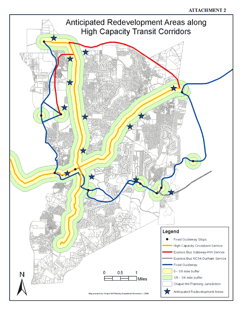
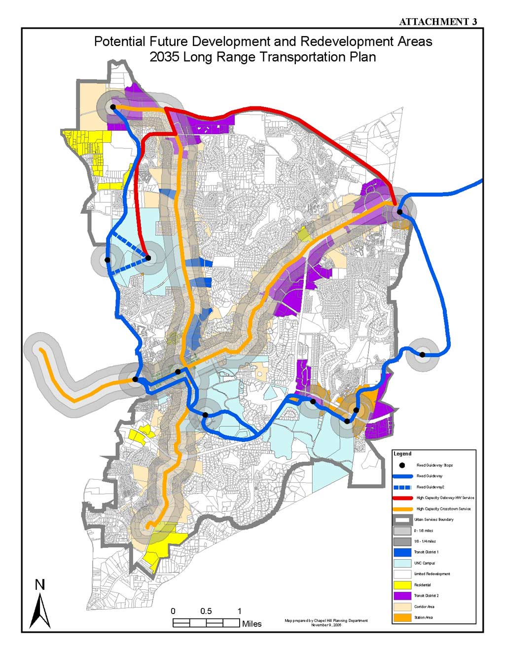
The draft 2035 projections include the designation of transit corridors along US 15-501 and Franklin Street. A second corridor is assumed along NC86/Martin Luther King Blvd, Columbia Street and US 15-501 South. The corridors are shown on the attached maps. The draft projections are also based on the identification of primary redevelopment districts, stations areas along the future fixed guideway transit corridor, redevelopment within downtown, additional development on UNC main campus, and development on the UNC Carolina North campus. The projections include the same estimates for the UNC Carolina North campus as were used in the 2030 Long Range Transportation Plan. The process for creating the projections is described in greater detail in Attachment 1.
Map 1 (Attachment 2) shows the primary redevelopment districts denoted with stars. Map 2 (Attachment 3) is more detailed, showing the land included in the primary redevelopment district areas. We do not anticipate that every parcel identified on this map would be redeveloped by 2035 but these general areas are good candidates for higher intensity redevelopment, due to their proximity to transit or other conditions and trends.
Town Staff will review citizen comments from the November 20th forum as well as comments from Town advisory committees, and will prepare final projections for the Council’s consideration and approval on December 4, 2006. At this time, neither the Planning Board nor the Transportation Board has met to review the projections, but both are scheduled to meet before the December 4, 2006 Council meeting. We will include their comments at that time.
The Transportation Advisory Committee is expected to receive the final draft regional projections on December 13, 2006 and release the projections for public comment. The Committee is scheduled to hold a public hearing on January 10, 2007, and approve the final projections on February 14, 2007.
As part of the process for preparing the regional socio-economic projections, it is possible that estimates approved by the Council may need to be revised to conform to regional control totals before final TAC approval. The control totals, based on statewide and regional growth projections, provide projections for housing, population, and employment, at the County level. Because each planning jurisdiction in Orange County prepares its own projections independently, once all estimates are combined and compared to the control totals, there may be a need for some revisions in order to maintain consistency with the control totals.
It is also possible that after the TAC releases the projections for public comment, additional revisions may be made. In the event of revisions made at the regional level either due to control totals or public comment, we will provide the Council with additional information.
The socio-economic projections will be used with the regional transportation model to assess transportation impacts. The 2035 Long Range Transportation Plan is scheduled for final approval in early 2008.