AGENDA #1b
|
TO: |
Roger L. Stancil, Town Manager |
|
|
|
|
FROM: |
J. B. Culpepper, Planning Director |
|
|
Gene Poveromo, Development Coordinator |
|
|
|
|
SUBJECT: |
Public Hearing: Greenbridge Development – Application for a Zoning Atlas Amendment (PIN #s 9788-06-5324, 9788-06-6235, 9788-06-6277, 9788-06-6325, 9788-06-6297, 9788-06-7213, and 9788-06-7383) |
|
|
|
|
DATE: |
January 17, 2007 |
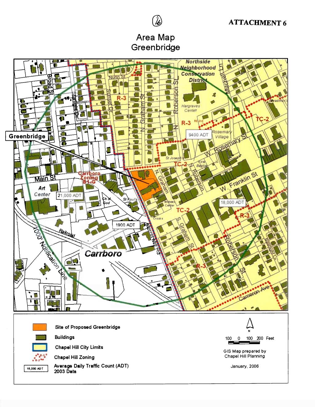
Tonight, the Council is considering a request for a Zoning Atlas Amendment to rezone a 1.32-acre site from Town Center-2 (TC-2) to the proposed Town Center-3-Conditional (TC-3-C) zoning district. The seven lot assemblage is located on the south side of West Rosemary Street between Merritt Mill Road and North Graham Street and is identified as Orange County Property Identifier Numbers 9788-06-5324, 9788-06-6235, 9788-06-6277, 9788-06-6325, 9788-06-6297, 9788-06-7213, and 9788-06-7383.
The applicant has submitted two accompanying applications for: 1) a Land Use Management Ordinance Text Amendment; and 2) a Special Use Permit. The Special Use Permit application proposes to construct a mixed-use building with 90 residential dwelling units and 216 parking spaces. The Land Use Management Ordinance Text Amendment proposes to create a new zoning district, Town Center-3 (TC-3). Please see the accompanying memorandums for additional information.
This package of material has been prepared for the Town Council’s consideration, and is organized as follows:
Zoning determines the type and intensity of uses and development that are allowed on a piece of land. A Zoning Atlas Amendment involves a change to the current zoning, and thus the permitted types and intensity of land uses. In Chapel Hill, a rezoning may be requested in two ways: general use and conditional use rezoning requests. A general use rezoning request is to change the zoning to a different zoning district in which any of several kinds of developments and uses are permissible. A conditional use rezoning request is to allow development and uses only with approval of a Special Use Permit. This rezoning application is a conditional use rezoning request and is therefore accompanied by a Special Use Permit application.
The zoning designation of a property determines the range of land uses and development intensities permitted on the property. Article 4.4 of the Land Use Management Ordinance establishes the intent of Zoning Atlas Amendments by stating that, “In order to establish and maintain sound, stable, and desirable development within the planning jurisdiction of the Town it is intended that this chapter shall not be amended except:
Article 4.4 further indicates:
It is further intended that, if amended, this chapter be amended only as reasonably necessary to the promotion of the public health, safety, or general welfare, and in conformance with the Comprehensive Plan.
The Council has discretionary authority to approve or deny a rezoning request. With a conditional use rezoning request, the specific proposal in the accompanying Special Use Permit application is related to the rezoning request. We believe it is appropriate for the Council to consider a specific Special Use Permit proposal on that application, in tandem with a rezoning hearing. If the Council does not find the Special Use Permit proposal to be an acceptable use of the property, we recommend that the Council not approve the rezoning request.
Opportunity for a protest petition to a proposed amendment to the Zoning Atlas is provided for under North Carolina Statutes. If a protest petition is filed with the Town Clerk, the proposed rezoning shall not become effective except by favorable vote of not less than seven (7) members of the Town Council. Copies of protest petition forms and additional information are available from the Planning Department.
Analysis of this application is organized around the requirement of the Land Use Management Ordinance that Article 4.4 of the Land Use Management Ordinance shall not be amended except: a) to correct a manifest error in the chapter; or b) because of changed or changing conditions in a particular area or in the jurisdiction generally; or c) to achieve the purposes of the Comprehensive Plan.
A) A rezoning is necessary to correct a manifest error.
Staff Comment: We believe the information in the record to date can be summarized as follows:
Arguments in Support: We were unable to identify any arguments in support of a manifest error.
B) A rezoning is necessary because of changed or changing conditions in a particular area or in the jurisdiction generally.
Staff Comment: We believe the information in the record thus far can be summarized as follows:
Arguments in Support: No arguments have been made to date in support of changed or changing conditions in this particular area.
C) A rezoning is necessary to achieve the purposes of the Comprehensive Plan.
Staff Comment: We believe the information in the record thus far can be summarized as follows:
Arguments in Support: Arguments in support of this finding are offered in the applicant’s Statement of Justification (Attachment 4), which provides several references to the Comprehensive Plan. Portions of the applicant’s Statement of Justification are copied below:
Section 2: Goals and Objectives
Economic Vitality: Objectives for economic vitality include: 1) Provide a diversity of densities, scales, land uses and sizes; 2) Utilize available land in an economically optimal fashion; 3) Provide a safe and secure environment for citizens in the downtown area (page 9 Town of Chapel Hill Comprehensive Plan).
Greenbridge accomplishes all of these objectives. It provides a diversity of scale and use within the matrix of town center buildings and uses. It is also an economically optimal use of this particular site for many reasons; among them the availability of existing infrastructure, net tax gain to the town and county, provision of new retail and commercial opportunity and provision for residential use in the town center district. [Applicant Statement]
Section 2: Town Character and Land Use
Objectives for Character and Land Use include: 1) Maintain existing, and encourage new, magnets to attract people to downtown; and 2) Promote compatible residential uses in the commercial zones of downtown (page 10 Town of Chapel Hill Comprehensive Plan).
Greenbridge will be a magnet for people to come downtown because of the unique mix of commercial and public uses anticipated on this site. It also represents compatible residential use in a commercial zone. [Applicant Statement]
Additional Information: We note that the Comprehensive Plan, adopted on May 8, 2000, identifies this area as town/village center, in the adopted Land Use Plan, a component of the Comprehensive Plan.
Recommendations are summarized below. Please see the attached summary of recommendations from the Planning Board.
Planning Board Recommendation: On December 19, 2006, the Planning Board voted 6-1 to recommend approval of the Zoning Atlas Amendment application. Please see the attached Summary of Planning Board Action.
Preliminary Recommendation: We believe that the rezoning could be justified based on finding C, as described above, as enhancing the downtown’s role as the center of the community. Our preliminary recommendation is that the Council enacts the attached ordinance, rezoning the property from Town Center-2 (TC-2) to Town Center-3-Conditional (TC-3-C).
The attached Resolution would deny the rezoning request.