ATTACHMENT 1
STAFF REPORT
|
SUBJECT: |
Public Hearing: Greenbridge Development –Special Use Permit |
|
|
(File No.9788-06-5324) |
|
|
|
|
DATE: |
January 17, 2006 |
INTRODUCTION
Attached for your consideration is an application for a Special Use Permit to allow the construction of a 10-story mixed-use development with residential, convenience/general-type business, and office-type business uses. The application proposes up to 106 residential dwelling units with two levels of structured parking and 216 parking spaces. The 1.32-acre, seven lot assemblage, is located on the south side of West Rosemary Street between Merritt Mill Road and North Graham Street. The proposed development has a total of 216,540 square feet of floor area, with a vertical mix of uses, comprised of approximately 176,919 square feet of residential floor area and 39,621 square feet of convenience/general-type business and office-type business floor area. The site is located in Town Center-2 (TC-2) and the Downtown Service District. The site is identified as Orange County Property Identifier Numbers 9788-06-5324, 9788-06-6325, 9788-06-6235, 9788-06-6277, 9788-06-6297, 9788-06-7213, and 9788-06-7383.
Accompanying this application, the applicant has submitted applications for a Land Use Management Ordinance Text Amendment proposing to create a new zoning district, Town Center-3 (TC-3); and a Zoning Atlas Amendment application, which proposes to rezone the site from the current Town Center-2 (TC-2) to the proposed Town Center-3-Conditional (TC-3-C) zoning district. Please see the accompanying memoranda for these applications.
Please note that the Special Use Permit will be discussed with the assumption that two accompanying applications will be enacted because the Special Use Permit proposal is only possible with these actions preceding it.
The Community Design Commission reviewed a Concept Plan for this proposal on January 24, 2006. The Town Council reviewed a Concept Plan for this proposal on February 20, 2006. Copies of the respective summary and minutes are in Attachments 9 and 10.
BACKGROUND
|
January 24, 2006 |
The Community Design Commission reviewed a Concept Plan for the Greenbridge Development. The proposal for mixed-use development included 184,000 square feet of floor area and 195 parking spaces (Attachment 9). |
|
|
|
|
February 20, 2006 |
The Town Council reviewed a Concept Plan for the Greenbridge Development. The proposal for mixed-use development included 184,000 |
square feet of floor area and 195 parking spaces (Attachment 10).
EVALUATION
Town staff has reviewed this application for comparison with the standards of the Land Use Management Ordinance and the Design Manual and offers the following evaluation. Please note that the Special Use Permit will be discussed with the assumption that two accompanying applications will be enacted because the current Special Use Permit proposal is only possible with these actions preceding it.
Existing Conditions
Location: The 1.32-acre, seven lot assemblage, is located on the south side of West Rosemary Street between the east side of Merritt Mill Road and the west side of North Graham Street. The west side of Merritt Mill Road is located in the Carrboro Town Limits.
Developments adjacent to the site include a three story residential development to the west, across Merritt Mill Road; to the north, across Rosemary Street, is the Northside Neighborhood with single-family residences and a Town parking lot; to the east, across North Graham Street, is the Oriental Garden Restaurant, a single family home, and Tar Heel Taxi; and to the south is Knotts Funeral Home and Empowerment, Inc.
Existing Structures: Existing structures on the site include a long term residential facility with 12 lodging units, the Abundant Life Church, the Queen of Sheba Restaurant, and a single-family residence. All of the existing structures are proposed for demolition to make room for the proposed development.
Access: There are currently five points of vehicular access from North Graham Street and Merritt Mill Road. A public sidewalk is located on the Merritt Mill Road frontage of the site.
Topography, Drainage, Vegetative Cover: The site is essentially flat, with a minor downward grade toward the northeast, at the intersection of West Rosemary Street and North Graham Street. The site generally drains from the southwest to the northeast.
The site contains little vegetation and is largely covered with buildings. Existing vegetation includes two specimen trees; a 20-inch oak and an 18-inch cedar; a 30-inch oak is located off-site at the southwest corner. The root zone of this 30-inch oak tree extends onto the site. Additionally, there are 10 smaller hardwoods scattered about the center and northeast corner of the site.
Development Description
The applicant proposes to construct one four story building, with two accompanying high rise elevations of seven and ten stories each. The proposal includes 216,540 square feet of floor area, including retail, office and up to 106 residential dwelling units. The applicant is proposing 7.5% affordable dwelling units on-site and a payment in lieu of 7.5% affordable units. A total of 216 parking spaces are proposed. Vehicular access to a below grade parking facility is proposed from North Graham Street and from Merritt Mill Road.
The applicant is proposing to install streetscape improvements along West Rosemary Street, North Graham Street, and Merritt Mill Road. Bicycle parking facilities are also proposed on site. The applicant is proposing to manage stormwater impacts by installing a stormceptor and four underground stormwater storage tanks. Private refuse collection service is proposed. The applicant has proposed to locate all utilities, including three-phase electric lines, underground.
Concept Plan Proposal / Special Use Permit Application Comparison
The Concept Plan Proposal was reviewed by the Town Council on February 20, 2006 and by the Community Design Commission on January 24, 2006. Copies of the Community Design Commission and Town Council Concept Plan comments, including the applicant’s response to these comments are attached to this memorandum (Attachments 9, 10 and 11). Please also refer to Attachment 12, which compares the Council Concept proposal with the current Special Use Permit proposal.
Ordinance Requirements
The staff evaluation of the Special Use Permit application will be discussed in this memorandum based on the supposition that:
1) The accompanying application for the Text Amendment creating a Town Center-3 zoning district will be enacted, with the standards and amended regulations as recommended by staff; and
2) That the Zoning Atlas Amendment application, to rezone the site from Town Center-2 to Town Center-3-Conditional, will be enacted by the Council.
Zoning: The proposed dwelling unit density and floor area comply with the proposed Town Center-3 (TC-3) district land use intensity standards. The proposed standards are the standards recommended by staff in the accompanying memorandum on the proposed text amendment creating a Town Center-3 zoning district.
Modifications to the Regulations: As proposed, the Special Use Permit application does not comply with two land use intensity standards in the staff recommended Town Center-3 zoning district. Specifically the application does not comply with the following regulations: 1) setbacks and height standards in Section 3.8.4 - Transitional Control Intensity Modifications, and 2) the definition of Building Envelope as defined in Appendix A of the Land Use Management Ordinance.
We recommend that the applicant either comply with the requirements and standards of the recommended Town Center-3 zoning district or ask the Council to modify the requirements of the Land Use Management Ordinance for each of the noted items.
Intensity Standards (floor area): The applicant is proposing 216,540 square feet of floor area; including 176,919 square feet of residential floor area (up to 106 residential units) and 39,621 square feet of convenience/general-type business and office-type business floor area. The proposed floor area is within the maximum permitted floor area of the proposed TC-3 zoning district.
The applicant originally proposed approximately 81.7% of the floor area (176,919 sq. ft) for residential use and approximately 18.3% of the floor area (39,621 sq. ft.) for convenience/general-type business and office-type business use. The applicant has revised the request to allow for flexibility to adjust the percentage of floor area square footage devoted to residential and non-residential use. We recommend that the applicant be given flexibility in regard to the mix of residential and non-residential (office/retail) uses. As proposed by the applicant, we recommend that that the residential floor area be permitted to be no less than 151,578 square feet (70%) and nor more than 194,866 square feet (90%). We recommend that the retail/office floor area be permitted to be no less than 21,654 square feet (10%) and no more than 64,962 square feet (30%). We have included a stipulation to this effect in Resolution A.
Dimensional Standards (setbacks): In the proposed Town Center-3 zoning district, zero-setback standards generally apply for the street, interior and solar setbacks. The applicant is proposing zero setbacks on all property lines except the southern property line, adjacent to Knott’s Funeral Home. A 15-foot setback is proposed along this southern property line.
Dimensional Standards (height): As recommended by staff in the accompanying text amendment memorandum, the maximum height limits for primary and secondary height limits in the Town Center-3 zoning district are 44 (at the setback line) and 120 feet respectively. The applicant is proposing maximum primary and secondary heights 44 and 117 feet.
Dimensional Standards (building envelope): The applicant is proposing to expand the building envelope beyond what is permitted in the proposed Town Center-3 zoning district, as recommended by staff in the accompanying text amendment memorandum. We recommend that the applicant either comply with the requirements and standards of the recommended Town Center-3 zoning district or ask the Council to modify the requirements of the Land Use Management Ordinance, in this particular situation.
Special Dimensional Standards (Transitional Control Intensity Modifications): Because the proposed development site is adjacent to a residential zoning district (Residential-3 on the north side of West Rosemary Street, the portion of the proposed development located on West Rosemary Street is subject to the Transitional Control Intensity Modifications (Section 3.8.4) in the Land Use Management Ordinance. That section of the ordinance is copied below:
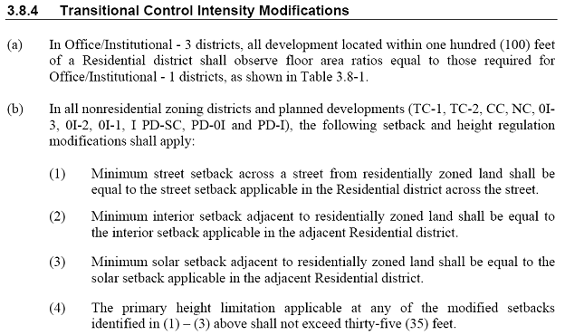
Section 3.8.4 of the Land Use Management Ordinance includes provisions intended to lessen the impact of non-residential development on adjacent residential zoning districts. The provisions of this section propose to minimize the impacts of non-residential structures by reducing building heights and building envelope areas and increasing building setbacks between the proposed development and the adjacent residential neighborhood.
The northern property line of the site, along West Rosemary Street, is adjacent to the Residential-3 (R-3) zoning district in the Northside neighborhood. Therefore the Transitional Control Intensity Modification standards specify a street setback of 24 feet and a maximum primary height of 35 feet at the 24 foot setback line. The applicant will hand out a detailed request for modifications to regulations, including the specific location, quantity, and accompanying graphics of such modifications at tonight’s Public Hearing.
Recreation Space: The proposed Town Center-3 zoning district requires that the applicant provide 7,224 square feet of recreation space. The applicant is proposing to provide 7,224 square feet of on-site recreation space. We recommend that the applicant provide 7,224 square feet of on-site recreation space. We have included a stipulation to this effect in Resolution A.
Affordable Housing Proposal: The applicant is proposing 1) 7.5% affordable dwelling units on-site and 2) a payment in lieu of 7.5% affordable units. In accordance with objectives in the Town Comprehensive Plan, we recommend that the applicant provide no less than 15% of the total proposed dwelling units as on-site affordable units.
We recommend that the applicant provide an Affordable Housing Plan that addresses: 1) the provision of 15% affordable units; 2) the eligibility of owners; 3) the marketing the units; 4) setting rates; 5) the assurance of the time period that units will be affordable; and 6) the assurance that units will remain affordable. We believe that the review and approval of an Affordable Housing Plan, by the Town Manager, prior to issuance of a Zoning Compliance Permit, will accomplish the affordable housing goals of the Town Council and those specified in the Town’s Comprehensive Plan. We have included a stipulation to this effect in Resolution A.
Schools Adequate Public Facilities Ordinance: The proposed development is subject to the provisions of the Schools Adequate Public Facilities Ordinance. We have included a stipulation to this effect in Resolution A.
Transportation
Traffic Impact: A Traffic Impact Analysis (TIA) was prepared by the Town Consultant in accordance with the Town’s TIA guidelines. The purpose of this study is to determine the impact to the surrounding transportation system caused by the additional traffic generated by the proposed Greenbridge Development, which is anticipated to be fully built out by the year 2010. Traffic volumes from several recent and proposed developments projects (Rosemary Village, The Franklin Hotel, Chipotle Restaurant, Shortbread Lofts, and Parking Lot #5/Wallace Parking Deck) were included in the analysis of future conditions. Future traffic conditions were also considered by applying an annual growth rate of 3%.
To determine the traffic impacts of the proposed site development, traffic conditions were analyzed at three arterial segments and five intersections for the 2006 Existing conditions, 2010 No build Conditions, and 2010 Build Conditions. Please see Attachment 8 for the Executive Summary of the TIA.
In general, the TIA report does not indicate significant traffic impact by the proposed development. However, the peak hour intersection capacity analysis for 2006 Existing Conditions, 2010 No Build Conditions, and 2010 Build Conditions at the intersection of Franklin Street/Main Street with Merritt Mill Road/Brewer Lane either approaches or exceeds the intersection capacity limits under all the three conditions analyzed.
Two alternative mitigation measures were analyzed at the intersection of Franklin Street/Main Street and Merritt Mill Road/Brewer Lane to improve the operation as provided below:
- Convert Merritt Mill Road to one-way between Franklin Street and Rosemary Street
- Restrict ingress/egress between Brewer Lane and Franklin Street/Main Street to right-in/right-out only
The above alternative mitigation measures were discussed with North Carolina Department of Transportation (NCDOT) and the Town of Carrboro. It was determined that the alternative mitigation measures were not feasible because of right-of-way constraints, and that Carrboro and Chapel Hill are not recommending changes to circulation patterns at this time. Instead, we recommend revising the signal timing/phasing at the intersection to improve the traffic flow conditions, including pedestrians. We recommend that the applicant provide a $6,000 payment-in-lieu for revising the traffic signal timing/phasing plans on the Franklin St/Rosemary St/Main St Corridor. We have included a stipulation to this effect in Resolution A.
In addition, we make the following recommendations related to pedestrian and vehicular safety.
We recommend that the applicant upgrade the existing traffic signals at the Graham Street / West Franklin Street and West Franklin Street / Merritt Mill Road intersections to provide for pedestrian improvements at the intersections prior to the issuance of a Certificate of Occupancy. We recommend that the improvements include pedestrian signal heads, audible pedestrian signals and a revised phasing plan to provide for pedestrians. We have included a stipulation to this effect in Resolution A.
We recommend that traffic channelization measures be incorporated into the loading/refuse collection area. For pedestrian safety purposes, we recommend that the applicant provide details of proposed refuse/loading vehicle circulation patterns, subject to Town Manager approval, prior to issuance of a Zoning Compliance Permit. We have included a stipulation to this effect in Resolution A.
We recommend that stops signs and audible warnings be provided at parking lot ramp exits to enhance pedestrian safety, with design subject to Town Manager approval prior to issuance of a Zoning Compliance Permit. We have included a stipulation to this effect in Resolution A.
Vehicular Access and Circulation: The applicant is proposing two points of vehicular ingress and egress; one on North Graham Street and one on Merritt Mill Road. Each point of access connects to two separate below-grade parking areas.
We recommend that the applicant provide two points of vehicular access to the site, one on North Graham Street and one on Merritt Mill Road, accessing two levels of below-grade parking, with the design subject to Town Manager approval, prior to issuance of a Zoning Compliance Permit. We have included a stipulation to this effect in Resolution A.
The applicant is also proposing to dedicate additional right-of-way on the three street frontages ranging from 4 to 17 feet and to construct wider sidewalks. Resolution A includes a stipulation requiring the dedication of the right-of-way.
Vehicular Parking: The Land Use Management Ordinance requires a minimum of 199 vehicular parking spaces for the proposed development; 109 spaces for the proposed convenience/general-type business and office-type business floor area and 90 spaces for the proposed residential dwelling units. The applicant is proposing to satisfy the minimum parking requirement with 216 vehicular parking spaces, including 7 handicapped spaces, in a below-grade garage. One level of parking is proposed to be dedicated to residential parking and the other level is to be for convenience/general-type business and office-type business parking as well as residential spill-over.
The proposed number of vehicular parking spaces falls within the Council parking policy to allow a maximum number of parking spaces equivalent to 110% of the minimum required. The parking spaces are proposed to be shared between residential and office uses. We recommend that the applicant provide 216 vehicular parking spaces. We recommend that the design of the parking deck be reviewed and approved by the Town Manager, prior to issuance of a Zoning Compliance Permit. We have included a stipulation to this effect in Resolution A.
We recommend that the parking lot be designed and constructed to Town standards, subject to Town Manager approval, prior to issuance of a Zoning Compliance Permit. We have included a stipulation in Resolution A to this effect.
Pedestrian Access: This proposed development includes frontage on three public streets: West Rosemary Street, North Graham Street and Merritt Mill Road. The applicant is proposing an open pedestrian plaza with entrances from Merritt Mill Road and West Rosemary Street. In additional to streetscape improvements, the applicant is also proposing benches and bicycle racks near the entrance to the plaza.
Streetscape: Existing public sidewalks are on the Merritt Mill Road and North Graham Street frontages of the site. The applicant is proposing to dedicate right-of-way to the face of the building on the Merritt Mill Road, West Rosemary Street, and North Graham Street frontages and provide 30-inch curb and gutter, 10 to 12 foot-wide sidewalks, with streetscape improvements, including amenity strips, trees and tree grates and decorative lighting. The applicant is also proposing public streetscape improvements including a brick amenity strip at the back of curb with trees, tree grates, and decorative lighting. Five-foot sidewalks are proposed to wrap around the back of the building.
We recommend that the applicant provide 30-inch curb and gutter, 10 to 12 foot-wide sidewalks, including amenity strips, trees and tree grates and decorative lighting on Merritt Mill Road, West Rosemary Street, and North Graham Street frontages of the site. Plans are subject to Town Manager approval, prior to issuance of a Zoning Compliance Permit. We have included a stipulation to this effect is included in Resolution A.
We recommend that the sidewalk paving design be modified near the northwest corner of the site where the concrete portion of the sidewalk is currently shown as less than five feet wide. Where the setback of the building from the curb is less than 10 feet, we recommend that the applicant provide a sidewalk whose concrete portion is a minimum of 6 feet wide, design subject to Town Manager approval, prior to issuance of a Zoning Compliance Permit. We have included a stipulation to this effect is included in Resolution A.
We recommend that the applicant provide structural soil to create tree planting pits in the streetscape, a minimum of 10 feet long, 5 feet wide, and two feet deep, design subject to Town Manager approval, prior to issuance of a Zoning Compliance Permit. A stipulation to this effect is included in Resolution A.
We recommend that the applicant position the trees proposed at grade, behind the curb on Graham Street, in a way that does not conflict with pedestrian access to on-street parking (car doors opening), design subject to Town Manager approval, prior to issuance of a Zoning Compliance Permit. A stipulation to this effect is included in Resolution A.
Bicycle Parking: The Land Use Management Ordinance requires a minimum of 10 bicycle parking spaces for the office/retail portion of the development and 102 for the proposed residential units, for a total of 112 parking spaces. The applicant is proposing to provide secure bicycle parking facilities for 15% of the building’s occupants.
The applicant is not specific about how many bicycle parking spaces or where the parking facilities will be located. We recommend that this development provide a minimum of 112 bicycle parking spaces that comply with the Class I and Class II Design Manual standards for location and design of bicycle parking facilities. We have included a stipulation to this effect in Resolution A.
We recommend that the applicant either comply with the requirements and standards of the recommended Town Center-3 zoning district or ask the Council to modify the requirements of the Land Use Management Ordinance.
Bus Stops: There are a number of existing bus-stops located on West Rosemary Street, West Franklin Street and Merritt Mill Road. Several of the stops are within walking distance from the proposed development. We believe that the proposed development would benefit from a mid-block bus stop on the West Rosemary Street frontage. We recommend that the applicant provide a mid-block bus pull-off (with approximately 5 by 80 foot dimensions), a bus stop shelter, with a solar generated passenger information system and lighting, a bench, and trash receptacle. We also recommend that the applicant provide a signed pedestrian crosswalk on West Rosemary Street, to the west of Graham Street. We have included a stipulation to this effect in Resolution A.
Transportation Management Plan: We recommend that a Transportation Management Plan be approved by the Town Manager prior to issuance of a Zoning Compliance Permit for the convenience/general-type business and office-type business portion of the development. This plan shall be updated and approved annually by the Town Manager. The required components of the Transportation Management Plan shall include:
a) Provision for designation of a Transportation Coordinator;
b) Provisions for an annual Transportation Survey and Annual Report to the Town Manager;
c) Quantifiable traffic reduction goals and objectives;
d) Ridesharing incentives;
e) Public transit incentives; and
f) Other measures subject to approval by the Town Manager.
We have included a stipulation to this effect in Resolution A.
Landscaping and Architectural
Buffers and Landscaping: The Land Use Management Ordinance does not require landscape buffers between this proposal and adjacent land uses. The applicant is proposing to include green roofs, vegetated roof-tops that are irrigated partly by captured rain water.
Landscape Protection, Planting and Maintenance Plan: The site contains little vegetation and is largely covered with buildings. Existing vegetation includes two specimen trees; a 20-inch oak and an 18-inch cedar; a 30-inch oak is located off-site at the southwest corner, its root zone extending onto the site. The site is proposed to be cleared for development.
We recommend that the Landscape Protection Plan identify the specimen trees proposed for removal. We recommend that the applicant take extra care to protect the 30-inch Oak located off-site at the southwest corner, whose root zone extends onto the site. We recommend that the applicant provide a chain-link fence around the southwest corner of the site for this purpose. We recommend that a Landscape Protection, Planting and Maintenance Plan, including a plan for the proposed green roofs, and similar green areas, be approved by the Town Manager prior to issuance of a Zoning Compliance Permit. We have included stipulations to this effect in Resolution A.
Building Elevations and Lighting: We recommend that detailed building elevations and lighting plans be approved by the Community Design Commission prior to the issuance of a Zoning Compliance permit. We recommend that the Community Design Commission approve a lighting plan for this site and take additional care during review to ensure that the proposed lighting plan will minimize 1) upward light pollution and 2) offsite spillage of light, prior to issuance of a Zoning Compliance Permit. We have included stipulations to this effect in Resolution A.
Environmental
Leadership in Energy and Environmental Design Certification: The applicant is proposing to construct the Greenbridge Development to the Leadership in Energy and Environmental Design (LEED) certification standard. The intent of LEED standards is to assist in the creation of high performance, healthful, and environmentally sound buildings awarded points in six categories, including Sustainable Sites, Water Efficiency, Energy and Atmosphere, Materials and Resources, Indoor Environmental Quality, and Innovation and Design Process. The LEED point system has three levels of increasing performance requirements, including silver, gold, and platinum. The Greenbridge Development is proposing to obtain gold LEED certification, with 43 performance credits. Please see Attachment 19 for additional information.
Watershed Protection and Resource Conservation Districts: This site is not located within the Watershed Protection District or the Resource Conservation District.
Impervious Surface: The Town Center zoning districts are not subject to impervious surface limits. Approximately 47% of the existing gross land area of the site (28,292 square feet) is covered by impervious surface. The applicant is proposing to add 29,496 square feet of new impervious surface area to the site; approximately 96% of the site, at ground level, will be covered by impervious surface area.
Stormwater Management: The applicant is proposing to manage post-development stormwater impacts associated for stormwater quality by installing a stormceptor TSS removal device. The applicant is also proposing to manage stormwater rate and volume by installing four underground stormwater storage tanks. The applicant is proposing to use a portion of the water from the underground storage tanks for irrigating proposed vegetated green roofs. We recommend that the developer submit a Stormwater Management Plan for the site prior to issuance of a Zoning Compliance Permit. We have included this as a stipulation in Resolution A.
Erosion Control: We recommend that an Erosion Control Plan be submitted and approved by the Orange County Erosion Control Officer prior to issuance of a Zoning Compliance Permit. We have included a stipulation to this effect in Resolution A.
Refuse and Recycling
Refuse Management: The applicant is proposing to use private refuse service for the collection of refuse and recycling materials. The applicant’s proposal includes a trash compactor, cardboard compactor, and recycling carts in the southeastern part of the site, off Merritt Mill Road. We recommend that the final plans include dimensioned details as well as appropriate signage and lighting for the refuse area. We recommend that prior to the issuance of a Zoning Compliance Permit, the applicant provide a certified statement confirming private refuse collection for the proposed development or that the Town Manager review and approve refuse facility design for compliance with Town of Chapel Hill and Orange County Solid Waste standards. We have included a stipulation to this effect in Resolution A.
We recommend that prior to the issuance of a Zoning Compliance Permit, that the Town Manager review and approve a Solid Waste Management Plan, including provisions for private waste and recycling collection, management and minimizing of construction debris, and demolition waste.
Utilities and Service Issues
Utilities: The Ordinance requires that detailed utility plans be reviewed and approved by OWASA, Duke Energy Company, Public Service Company, BellSouth, Time Warner Cable and the Town Manager prior to issuance of a Zoning Compliance Permit. We have included a stipulation to this effect in Resolution A.
The applicant has proposed to that all utility service to the site to be placed underground, including three-phase electric lines. We recommend that all utility service to the site to be placed underground, including three-phase electric lines, with design subject to Town Manager approval prior to issuance of a Zoning Compliance Permit. We have included a stipulation to this effect in Resolution A.
Fire: We recommend that a fire flow report, sealed by an engineer registered in the State of North Carolina, be provided for review and approval by the Town Manager prior to issuance of a Zoning Compliance Permit. We have included a stipulation to this effect in Resolution A.
We recommend that occupied floor heights be limited to 90 feet above finished grade unless 1) alternate, protected, egress paths are provided and 2) the building is protected by an automatic sprinkler system, the design subject to approval by the Town Manager prior to issuance of a Zoning Compliance Permit. We have included a stipulation to this effect in Resolution A.
Construction Management Plan: We recommend that a Construction Management Plan be approved by the Town Manager prior to issuance of a Zoning Compliance Permit. We recommend that the construction management plan: 1) indicating how construction vehicle traffic will be managed, 2) identify parking areas for on-site construction workers including plans to prohibit parking in residential neighborhoods, 3) indicate construction staging and material storage areas, and 4) identify construction trailers and other associated temporary construction management structures. We have included a stipulation to this effect in Resolution A.
Traffic and Pedestrian Control Plan: We recommend that the applicant provide a Work Zone Traffic Control Plan for movement of motorized and non-motorized vehicles on any public street that will be disrupted during construction. The plan must include a pedestrian management plan indicating how pedestrian movements will be safely maintained. The plan must be reviewed and approved by the Town Manager prior to the issuance of a Zoning Compliance Permit. At least 5 working days prior to any proposed lane or street closure the applicant must apply to the Town Manager for a lane or street closure permit. We have included a stipulation to this effect in Resolution A.
Comprehensive Plan: The Comprehensive Plan was adopted by the Council on May 8, 2000, which has two components pertinent to this development proposal, the Land Use Plan and the Downtown Small Area Plan.
Land Use Plan: The Land Use Plan, a component of the Comprehensive Plan, adopted by the Council on May 8, 2000, identifies this property as Town/Village Center Emphasis.
Downtown Small Area Plan: The Downtown Small Area Plan, a component of the Comprehensive Plan, adopted March 27, 2000, identifies the area of the proposed development as the Midway Area and contains the following goals for the downtown:
- Economic Vitality: To ensure Downtown Chapel Hill remains the center of the community’s government, commercial, spiritual, and cultural activities with appropriate public, office, commercial, and residential development, thereby continuing its economic vitality.
- Town Character/Land Use: Maintain and enhance the existing downtown as the social, cultural and spiritual center of Chapel Hill.
- Infrastructure / Public Services: Downtown facilities and services shall meet the physical, social, and cultural needs of the community.
- Transportation: Maintain and further develop multiple Downtown transportation systems and facilities to conveniently serve residents, businesses and their employees, customers, and visitors to Chapel Hill.
We believe that this proposal achieves these objectives. The Downtown Small Area Plan also includes Downtown Design Guidelines. These guidelines articulate design objectives that will guide the Community Design Commission as it reviews and approves the building elevations and lighting plans for this proposal. The key design objectives are:
- Buildings should be designed to be compatible, in form and proportion, with neighboring buildings.
- Buildings or groups of buildings should include a variety of forms, materials and colors, yet these elements should be composed to maintain a unified appearance.
- Buildings must include a richness of architectural detail to help define their scale.
- Buildings should extend to the back of the sidewalk.
SPECIAL USE PERMIT FINDINGS
Special Use Permit Findings
For approval of a Special Use Permit, the Council must make the following findings, as set forth in Article 4.5.2 of the Land Use Management Ordinance:
(a) That the use or development is located, designed, and proposed to be operated so as to maintain or promote the public health, safety, and general welfare;
(b) That the use or development complies with all required regulations and standards of this Chapter, including all applicable provisions of the Land Use Management Ordinance;
(c) That the use or development is located, designed, and proposed to be operated so as to maintain or enhance the value of contiguous property, or that the use or development is a public necessity; and
(d) That the use or development conforms with the general plans for the physical development of the Town as embodied in the Land Use Management Ordinance and in the Comprehensive Plan.
Upon review of the application and information that has been submitted to date, our preliminary recommendation is that these findings can be made, with the modification of regulations noted previously.
CONCLUSION
Based on information available at this stage of the application review process, we believe that with:
1) The enactment of the accompanying Land Use Management Ordinance Text Amendment, as recommended by staff, to a create a Town Center-3 (TC-3) zoning district; and
2) The approval of the Zoning Atlas Amendment application to rezone the site from the current Town Center-2 (TC-2) to the staff recommended Town Center-3-Conditional (TC-3-C) zoning district; and
3) The necessary modification to the regulations as described in the staff report; and
4) The conditions in Resolution A
The proposed Special Use Permit with conditions in Resolution A and proposed Modifications to Regulations complies with the requirements of the Land Use Management Ordinance, the Design Manual, and that the proposal conforms with the Comprehensive Plan.
Resolution A would approve the application with conditions. Resolution B would deny the application.