AGENDA #1b
MEMORANDUM
TO: Mayor and Town Council
FROM: W. Calvin Horton, Town Manager
SUBJECT: Public Hearing: Rusch Hollow- Application for Special Use Permit
DATE: September 15, 2003
INTRODUCTION
We have received a request for a Special Use Permit which proposes a multi-family development containing 12 single family dwelling units, a two unit structure and a three unit structure. The 3.2 acre site is located on the east side of Rogers Road, between Purefoy Road and Rusch Road. Proposed access to the site is from Rogers Road and from the east end of Rusch Road. The tract is located in Orange County, outside the Town Limits of Chapel Hill, and is identified as Chapel Hill Township Tax Map 23, Block D, Lots 14, 15, and 20 (PIN’s 9870424466, 9870539615, 9870536626).
Accompanying this request is an application to rezone the site from Residential-1 (R-1) to Residential-Special Standards-Conditional (R-SS-C).
On April 8, 2002, the Town Council approved a request from Habitat for Humanity for expedited processing of the proposed Rusch Hollow development.
Tonight’s Public Hearing has been scheduled to receive evidence in support of and in opposition to approval of the application.
This package of materials has been prepared for the Town Council’s consideration, and is organized as follows:
· Cover Memorandum: Introduces application, describes process for review, summarizes staff and advisory board comments, and offers recommendations for Council action.
· Staff Report: Offers detailed description of site and proposed development.
· Attachments: Includes a checklist of requirements for this development, resolutions of approval and denial, advisory board comments, and applicant’s materials.
PROCESS
The Land Use Management Ordinance requires the Town Manager to conduct an evaluation of this Special Use Permit, to present a report to the Planning Board, and to present a report and recommendation to the Town Council. We have reviewed the application and evaluated it against Town standards; we have presented a report to the Planning Board; and tonight we submit our report and preliminary recommendation to the Council.
The standard for review and approval of a Special Use Permit application involves consideration of four findings (description of the findings follows below). Evidence will be presented tonight. If, after consideration of the evidence, the Council decides that it can make each of the four findings, the Land Use Management Ordinance directs that the Special Use Permit shall then be approved. If the Council decides that the evidence does not support making one or more of the findings, then the application cannot be approved and, accordingly, should be denied by the Council.
DESCRIPTION OF THE APPLICATION
The applicant is proposing to construct a multi-family residential development containing 17 dwelling units. Twelve single family dwelling units are proposed. Five multi-family units are also planned (one duplex and one triplex). The applicant is also proposing to create lots and common area as a townhouse development minor subdivision. A recreation area is also proposed.
Primary vehicular access to the site is proposed from a new street connection to Rogers Road including secondary access at the east end of Rusch Road.
Stormwater control for this development site, is proposed to be managed and address by a single stormwater pond/bio-retention facility.
In order to provide sewer service to this site, the applicant is proposing to install a new sewer main. Installation of this sewer line will require off-site construction of approximately 550 feet of public sewer line. Clearing limits associated with this proposed improvement are noted on the off-site sewer plan sheet.
BACKGROUND
A Concept Plan Review of this application was conducted by the Community Design Commission on March 25, 2002. The submission of the Special Use Permit application for this proposed development preceded the requirement for Concept Plan Review by the Council and also does not meet the threshold for Council review of a Concept Plan. On April 8, 2002, the Council granted expedited process to Habitat for Humanity for this project.
We have evaluated the application regarding its compliance with the standards and regulations of the Town’s Land Use Management Ordinance. We have prepared a Staff Report that discusses affordable housing, access and circulation, building elevations, buffers and landscaping, impervious surface limits, wetlands, steep slopes, stormwater management, refuse service, utilities, and fire safety (and is included as an attachment to this memorandum). A checklist describing compliance with regulations is also provided as an attachment to this memorandum.
Based on our evaluation, our preliminary recommendation is that the application as submitted, complies with the regulations and standards of the Land Use Management Ordinance and Design Manual with the conditions in Resolution A. We believe the proposal conforms with the Comprehensive Plan.
Tonight the Council receives our attached evaluation, and also receives information submitted by the applicant and other citizens. The applicant’s materials are included as attachments to this memorandum. All information that is submitted at the hearing will be placed into the record.
Based on the evidence that is submitted, the Council will consider whether or not it can make each of four required findings for the approval of a Special Use Permit. The four findings are:
|
Special Use Permit – Required Findings of Fact
Finding #1: That the use or development is located, designed, and proposed to be operated so as to maintain or promote the public health, safety, and general welfare.
Finding #2: That the use or development complies with all required regulations and standards of this Chapter, including all applicable provisions of Articles 3, and 5, the applicable specific standards contained in Supplemental Use Regulations (Article 6), and with all other applicable regulations;
Finding #3: That the use or development is located, designed, and proposed to be operated so as to maintain or enhance the value of contiguous property; and
Finding #4: That the use or development conforms with the general plans for the physical development of the Town as embodied in this Chapter and in the Comprehensive Plan.
|
Following the Public Hearing, we will prepare an evaluation of the evidence submitted in support of and in opposition to this application. If, after consideration of the evidence, the Council decides that it can make each of the four findings, the Land Use Management Ordinance directs that the Special Use Permit shall then be approved. If the Council decides that the evidence does not support making one or more of the findings, then the application cannot be approved, and accordingly, should be denied by the Council.
KEY ISSUES
Our full evaluation, with discussion of each of the required four findings, is included in the attached Staff Report. Based on the review of this development application by Town advisory boards and the Town staff, we believe that three key issues have been identified: 1) Preservation of the wetlands area; 2) Width of bicycle lane on Rogers Road; and 3) Process required for creation of lots. These issues are discussed below:
1) Preservation of the Wetlands Area: During a Resource Conservation District determination inspection by the Town’s Engineering Department, a portion of this site was identified as containing a wetland area that is regulated by the North Carolina Division of Water Quality and possibly the US Army Corps of Engineers. This wetland area is located in the northeast corner of the site and identified on the applicant’s site analysis sheet.
The applicant is proposing to construct a stormwater infiltration basin and a segment of the internal street on portions of this wetland area. The applicant is proposing to replace some of the wetland area with an infiltration basin intended to manage stormwater rate, quality and volume for the entire development, including individual residential lots. Although retention of this wetland area may help to satisfy the Town’s water quality standard, the applicant notes that the proposed stormwater infiltration basin will provide the added benefit of controlling stormwater rate and volume.
During the review of this proposal by the Planning Board, the Community Design Commission and the Parks and Recreation Commission concerns were raised about the impact of the proposed development on the wetlands areas. The Planning Board and the Community Design Commission recommended that construction of public or private improvements be prohibited on the portions of the wetlands within the proposed right-of-way in front of lots 10 and 11. The Planning Board and Community Design Commission recommendations further stated that future construction of public or private improvements within this area is to be prohibited unless authorized by Council action. These advisory boards also recommended that vehicular access to lot 10 be through a private access easement across lot 11, unless the Town Council authorizes construction across the wetland area in front of lots 10 and 11.
The Parks and Recreation Commission recommended that the preservation of the wetlands should supercede the creation of a recreation area. The Parks and Recreation Commission recommended that the 7,500 square foot recreation area may be decreased in size or eliminated, to minimize the impact of the development on the wetlands area. In-lieu of this recreation space, the portion of the proposed development identified as a 7,500 square foot recreation lot, may be use for stormwater management, as a portion of a residential lot, or for any other design element deemed appropriate by the Town Manager as a means to preserve the wetlands.
Comment: We understand that the applicant has agreed to remove the public street and utility improvements in the wetlands in front of lots 10 and 11. We also understand that the applicant can further minimize the impact on the wetlands by relocating the stormwater facility away from the wetlands and into the area currently proposed as recreation area. We anticipate that the applicant will present additional information on this item at tonight’s Public Hearing.
Resolutions A and B incorporate the recommendations of the Planning Board and the Community Design Commission prohibiting construction on portions of the wetlands within the right-of-way. Resolutions A and D incorporate the recommendation of the Parks and Recreation Commission authorizing elimination of the 7,500 square foot recreation area in order to relocate the stormwater management pond and preserve the wetlands area.
2) Width of Bicycle Lane on Rogers Road: The Transportation Board believes that a 16 foot wide lane is an appropriate width for a roadway designed to accommodate both vehicles and bicycles. The Board recommends that roadway improvements along the site’s Rogers Road frontage shall include a 16 foot widening of the roadway in order to accommodate a bicycle lane.
Comment: The Council’s current policy concerning the width of a roadway, designed to accommodate a single travel lane and bicycle lane, is 14 feet. Resolution A, the Manager’s Preliminary Recommendation, does not include the recommendation of the Transportation Board.
3) Process Required for Creation of Lots: Prior to selling any of the dwellings, lots will need to be created. The process to create the individual lots will require the Planning Board to review and approved a minor subdivision application. An application for a minor subdivision may be submitted after a Zoning Compliance Permit for final plan approval has been issued.
Comment: The recently adopted Land Use Management Ordinance requires that the Planning Board review and approve minor subdivision applications.
SUMMARY
We have attached a resolution that includes standard conditions of approval as well as special conditions that we recommend for this application. The special conditions that we recommend are described in detail in the accompanying staff report. With these conditions, we believe that the Council could make the findings regarding health, safety and general welfare, property values, and consistency with the Comprehensive Plan. The Manager’s recommendation incorporates input from all Town departments involved in review of the application.
Following is a brief outline describing the next steps in the development review process, should the Council approve the Special Use Permit application for this site:
1. Applicant accepts and records a Special Use Permit, which incorporates the terms of the Council-adopted resolution.
2. Applicant submits detailed Final Plans and documentation, complying with Council stipulations. Information is reviewed by Town departments and the following agencies:
3. Community Design Commission reviews and approves building elevations and site lighting.
4. Upon demonstration of compliance with remaining Council stipulations, Town staff issues a Zoning Compliance Permit authorizing site work. Permit includes conditions specific to the development and requires pre-construction conferences with Town staff.
5. Engineering Department issues an Engineering Construction Permit, authorizing work within the public right-of-way; and
6. Inspections Department issues Building Permits and Certificates of Occupancy.
RECOMMENDATIONS
Recommendations are summarized below. Please see summaries of board actions and recommendations in the attachments.
Planning Board Recommendation: On August 5, 2003, the Planning Board voted 8-0 to recommend that the Council approved this application, including three new stipulations and the modification of a fourth stipulation, with the adoption of Resolution B. Please see the attached Summary of Planning Board Action.
Resolution A, the Town Manager’s Preliminary Recommendation, and Resolution B, include all four recommendations of the Planning Board:
1. Construction in Wetlands: Construction of public or private improvements shall be prohibited on the portions of the wetlands within the proposed right-of-way in front of lots 10 and 11. Future construction of public or private improvements within this area shall be prohibited unless authorized by Council action.
2. Access to Lot 10 and 11: Access to lot 10 shall be through a private access easement across lot 11, unless the Town Council authorizes construction across the wetland area in front of lots 10 and 11.
3. Resource Conservation District Landscape Bufferyard: A minimum 6-foot wide landscape bufferyard, with trees, shall be provided on this proposed development site, between the Resource Conservation District area on the adjoining property to the east and the proposed stormwater management feature and recreation area. Existing vegetation may be used to satisfy the buffer requirement.
4. Recreation Area Improvements: Delete the requirement for a 6 foot high wooden privacy fence between the recreation area and the adjoining residential lot.
Transportation Board Recommendation: On August 19, 2003, the Transportation Board voted 5-0 to recommend that the Council approved this application, including one modified stipulation, with the adoption of Resolution C. Please see the attached Summary of Transportation Board Action.
Resolution C includes the recommended condition of the Transportation Board:
1. Rogers Road Improvements: That improvement along the site’s Rogers Road frontage shall include a 16 foot widening of the roadway in order to accommodate a bicycle lane.
Comment: Resolution A, the Manager’s Preliminary Recommendation recommends a 14 foot widening of the roadway in order to accommodate a bicycle lane, in accordance with Council policy. For additional information, please refer to the discussion on bicycle lanes in the section above under Key Issues.
Community Design Commission Recommendation: On August 20, 2003, the Community Design Commission voted 8-2 to recommend that the Council approved this application, including three new stipulations, and modification of another stipulation, with the adoption of Resolution B. Please see the attached Summary of Community Design Commission Action.
Resolution A, the Town Manager’s Preliminary Recommendation, and Resolution B, include all four recommendations of the Community Design Commission:
1. Construction in Wetlands: Construction of public or private improvements shall be prohibited on the portions of the wetlands within the proposed right-of-way in front of lots 10 and 11. Future construction of public or private improvements within this area shall be prohibited unless authorized by Council action.
2. Access to Lot 10 and 11: Access to lot 10 shall be through a private access easement across lot 11, unless the Town Council authorizes construction across the wetland area in front of lots 10 and 11.
3. Resource Conservation District Landscape Bufferyard: A minimum 6-foot wide landscape bufferyard, with trees, shall be provided on this proposed development site, between the Resource Conservation District area on the adjoining property to the east and the proposed stormwater management feature and recreation area. Existing vegetation may be used to satisfy the buffer requirement.
4. Recreation Area Improvements: Delete the requirement for a 6 foot high wooden privacy fence between the recreation area and the adjoining residential lot.
Parks and Recreation Commission Recommendation: On August 21, 2003, the Parks and Recreation Commission voted 9-0 to recommend that the Council approved this application, including one modified stipulation, with the adoption of Resolution D. Please see the attached Summary of Parks and Recreation Commission Action.
Resolutions A and D include the two following recommendations of the Parks and Recreation Commission:
1. Recreation Area Improvements: That the recreation area shall include recreational amenities deemed adequate by the Town Manager.
2. Wetlands Preservation: To minimize the impact of the development on the wetlands area, the 7,500 square foot recreation area may be decreased in size or eliminated. In-lieu of this recreation space, the portion of the proposed development identified as a 7,500 square foot recreation lot, may be use for stormwater management, as a portion of a residential lot, or for any other design element deemed appropriate by the Town Manager as, a means to preserve the wetlands.
Bicycle and Pedestrian Advisory Board Recommendation: On August 26, 2003, the Bicycle and Pedestrian Advisory Board voted 7-0 to recommend that the Council approved this application, including one modified stipulation, with the adoption of Resolution E. Please see the attached Summary of Bicycle and Pedestrian Advisory Board Action
Resolutions A and E include the recommended condition of the Bicycle and Pedestrian Advisory Board
1. Rogers Road Improvements: That the proposed sidewalk improvement along the site’s Rogers Road frontage shall be located within the right-of-way.
Manager’s Preliminary Recommendation: Based on our evaluation of the application, our preliminary conclusion is that, with the stipulations in Resolution A, the application complies with the standards and regulations of the Land Use Management Ordinance.
Following tonight’s Public Hearing, we will prepare an evaluation of the evidence submitted in support of and in opposition to this application. If the Council makes the required findings for approval of a Special Use Permit, we recommend that the application be approved with the adoption of Resolution A.
Resolution B would approve the application as recommended by the Planning Board and the Community Design Commission.
Resolution C would approve the application as recommended by the Transportation Board.
Resolution D would approve the application as recommended by the Parks and Recreation Commission.
Resolution E would approve the application as recommended by the Bicycle and Pedestrian Advisory Board.
Resolution F would deny the application.
Rusch Hollow - Special Use Permit
Differences Between Resolutions
|
ISSUES |
Resolution A (Approval)
Town Manager’s Preliminary Rec. |
Resolution B (Approval)
Planning Board, Community Design Comm. Rec. |
Resolution C (Approval)
Transportation Board Rec. |
Resolution D (Approval)
Parks & Rec. Commission Rec. |
Resolution E (Approval)
Bicycle & Ped. Advisory Brd Rec. |
|
Prohibit construction in portion of wetland area located in right-of-way |
Yes (Construction in wetlands prohibited unless approved by Council)
|
Yes (Construction in wetlands prohibited unless approved by Council)
|
* |
Yes |
* |
|
Access to lot 10 through lot 11 |
Yes |
Yes |
* |
* |
* |
|
Buffer along east property line near RCD |
Yes |
Yes |
* |
*
|
* |
|
Remove fence from recreation lot |
Yes |
Yes |
* |
* |
* |
|
Sixteen foot lane to accommodate wider bicycle lane |
No (Recommend Council policy of 14 foot lane) |
No (Recommend Council policy of 14 foot lane) |
Yes |
No (Recommend Council policy of 14 foot lane) |
No (Recommend Council policy of 14 foot lane) |
|
Recreational amenities approved by Town Manager |
Yes |
* |
*
|
Yes |
* |
|
Decrease or eliminate recreation area |
Yes (In order to preserve wetlands) |
* |
* |
Yes (In order to preserve wetlands) |
* |
|
Construct Roger Road sidewalk in right-of-way |
Yes |
* |
* |
* |
Yes |
* - Issues
not raised at advisory board meeting.
ATTACHMENTS
1. Planning Staff Report (p. 12).
2. Project Fact Sheet Requirements (p. 23).
3. Resolution A (Approving the application) (p. 24).
4. Resolution B (Approving the application) (p. 32).
5. Resolution C (Approving the application) (p. 34).
6. Resolution D (Approving the application) (p. 36).
7. Resolution E (Approving the application) (p. 38).
8. Resolution F (Denying the application) (p. 40).
9. Summary of Action- Planning Board (p. 41).
10. Summary of Action- Community Design Commission (p. 42).
11. Summary of Action- Transportation Board (p. 43).
12. Summary of Action- Parks and Recreation Commission (p. 44).
13. Summary of Action – Bicycle and Pedestrian Advisory Board (p. 45).
14. Correspondence from Friends of Bolin Creek (p. 46).
15. Statement of Justification (p. 47).
16. Project Fact Sheet (p. 53).
17. Area Map (p. 55).
18. Reduced Plan (p. 56).
STAFF REPORT
Subject: Public Hearing: Rusch Hollow - Application for Special Use Permit
Date: September 15, 2003
INTRODUCTION
We have received a request for a Special Use Permit for the development of 14 residential lots. The 3.2 acre site is located on the east side of Rogers Road, between Purefoy Road and Rusch Road. Proposed access to the site is from Rogers Road and from a new public street connection at the east end of Rusch Road. The tract is located in the northern Joint Planning Transition Area (JPA), outside the Town Limits of Chapel Hill, and is identified as Chapel Hill Township Tax Map 23, Block D, Lots 14, 15, and 20.
EVALUATION
The Town staff has reviewed this application for compliance with the standards of the Land Use Management Ordinance and the Design Manual and offer the following evaluation. This evaluation is based on the rezoning of the site to Residential-Special Standards-Conditional.
Existing Conditions
Location: The 3.2 acre “L” shaped site is located on the east side of Rogers Road, between Tallyho Trail and Purefoy Road, approximately 525 feet south of Purefoy Road. The southern stem of this “L” shaped parcel is adjacent to the dead end portion of Rusch Road, a public street.
The site is located in a residential neighborhood consisting of a mix of mobile homes, recently constructed Habitat for Humanity Homes, a number of modest older single family-homes and a range of more expensive single-family homes. Most lots in the immediate area are ½ acre or larger in size.
Existing Structures: Currently, the site does not contain any significant structures; however there is evidence of previous buildings and home sites. The portion of the site fronting Rogers Road includes the remains of a residential structure recently demolished by local fire fighters as part of a training exercise. Although not readily visible from recent site inspections, an aerial photograph submitted with the application, suggests that a second residential site once existed at the end of Rusch Road. In addition to several small dilapidated storage sheds, the site also contains some scattered piles of residential debris.
Access: The proposed development site has direct access to two streets maintained by the North Carolina Department of Transportation: Rogers Road and Rusch Road. Approximately 125 feet of the site fronts Rogers Road. One hundred fifty feet of the site is adjacent to Rusch Road. Rogers Road is 22 feet in width. Rusch Road is 18 feet wide. Neither road has curb, gutter or sidewalks.
Topography, Drainage, Vegetative Cover: Except for some steep slopes (15% to 20%) located along the east property line near the southeast corner of the site, most of site is level with slopes between 5% and 10%.
The property generally drains from west to east. The highest elevation of the site, 546 feet, is found along Rogers Road. The lowest points on the site, 516 feet, are along the east property line, associated with a small pond and surface drainage to an ephemeral stream on the adjoining property to the east. The project also has an area of wetlands in the northeast portion of the site.
Vegetative cover consists of pockets of abandoned overgrown residential yards and mixed stands of hardwoods and pines. Several stands of significant trees are present near the center of the site and along the east property line.
Development Description
Development: The applicant is proposing to construct a residential development consisting of fourteen lots containing 17 dwelling units. Single family dwelling units are proposed for twelve of the lots. The two remaining lots are proposed to contain rental units. Proposed rental units are planned for lot 1 (duplex) and lot 9 (triplex). A 7,500 square foot recreation area is also proposed.
Access: Primary vehicular access to the site is proposed from a new street connection to Rogers Road. A secondary street access is planned at the east end of Rusch Road. The applicant also intends to construct a sidewalk along one side of the proposed internal streets and along the property’s frontage on Rogers Road.
Stormwater: Stormwater control for this development site, including controls for rate, quality and volume for each individual residential lot, is proposed to be managed and address by a single stormwater pond/bio-retention facility.
Clearing: Except for preservation of existing vegetation in selected areas as shown on the Landscape Protection Plan, most of the site, including most of a 30-foot wide off-site sewer easement, is proposed to be cleared.
Off-Site Utilities: In order to provide sewer service to this site, the applicant is proposing to install a new sewer main. Installation of this sewer line will require off-site construction of approximately 550 feet of public sewer line. Clearing limits associated with this proposed improvement are noted on the off-site sewer plan sheet.
Ordinance Requirements
Zoning: This property and all surrounding properties on the east side of Rogers Road are located within the Town’s Joint Planning Transition Area and currently zoned Residential-1 (R-1). Properties on the west side of Rogers Road are located within Carrboro’s Joint Planning Transition Area and subject to Carrboro’s zoning regulations. Accompanying this Special Use Permit application is a request to rezone the proposed development site to the Residential-Special Standards-Conditional (R-SS-C) zoning district.
Residential-Special Standards-Conditional Zoning District: In 1999, the Town Council adopted an ordinance creating the Residential-Special Standards-Conditional (R-SS-C) zoning district. The intent of the Council’s action was to design a residential zoning district that, with flexible design standards for lot size, density and other land intensity specifications, would encourage development of affordable housing. Although R-SS-C zoning designation does not ensure or mandate an affordable housing component, it is the expressed expectation of the Council that the Special Use Permit application that accompanies an R-SS-C rezoning application would include a voluntary offer of affordability by the applicant.
Affordable Housing: This Special Use Permit application includes a voluntary offer by the applicant to provide, for sale and private ownership, 12 affordable single-family dwelling units. The applicant is also voluntarily offering five affordable rental units.
This offer of affordability is included in the applicant’s Statement of Justification and is described as follows:
“In its request for approval of a Special Use Permit, Habitat for Humanity of Orange County voluntarily agrees to include 100% of the housing units in Rusch Hollow as long-term affordable housing. Twelve of the units will be sold to households earning at or below 50% of the area median income. These homes will remain affordable for at least ninety-nine years, through the use of deed restrictions in accordance with the provisions of Orange County’s Affordable Housing Bond Program. These deed restrictions require that the homes be sold over a 99 year period only to households that earn 80% or less than the area median income. The five rental units will also be affordable for households at or below 50% of area median income, and will have similar deed restrictions that will ensure that they remain affordable over a 99 year period, also in accordance with the provisions of Orange County’s Affordable Housing Bond Program.” [Applicant’s Statement]
Resolution A includes a stipulation requiring that the applicant submit, for Town Manager review and approval, copies of the deed restrictions addressing the affordability component of this propose development. The documents must be approved by the Town Manager prior to the recordation of a final plat.
A homeowners association is proposed for this development. The homeowners association is proposed to own and be responsible for the maintenance and upkeep of three common areas; a 20-foot landscape bufferyard along Rogers Road, a 7,500 square foot recreation area, and a stormwater management facility. We recommend that prior to the recordation of the final plat, the applicant submit, for Town Manager review and approval, a copy of the homeowners association documents. We also recommend that concurrent with recordation of the subdivision plat, the applicant deed the three common areas to the homeowners association. These recommendations are stipulated in Resolution A.
Dimensional Standards: The proposed project meets the dimensional standards outlined in the Dimensional Matrix (Table 3.8-1) of the Land Use Management Ordinance’s for the Residential-Special Standards-Conditional zoning district. Table A compares the dimensional standards in the R-SS-C zoning district with standard proposed by the applicant.
|
TABLE A Comparison of R-SS-C Dimensional Standards and Rusch Hollow
|
||
|
Dimensional Standards |
Residential-Special Standards-Conditional |
Rusch Hollow (proposed intensity) |
|
|
||
|
Min Lot Size |
NA |
Between 4,700 and 7,500 square feet |
|
Max Density per Acre |
NA |
5.3 units/acre |
|
Min Street Frontage |
NA |
65 feet |
|
Minimum Lot Width |
NA |
65 feet |
|
Min Street Setback |
10 |
20 |
|
Min Interior Setback |
0 |
8 |
|
Min Solar Setback |
NA |
8 |
|
Max Impervious Surface |
24 % (low density option)
25%-50% (high density option with water quality feature) |
44% (high density option including on-site water quality feature) |
|
Maximum Floor Area |
56,136 sq ft |
20,000 sq ft |
NA – minimum/maximum standard not specified by the Land Use Management Ordinance. Standards proposed in these categories require Council approval.
Resolution A includes a stipulation authorizing the dimensional standards as proposed by the applicant in Table A.
Schools Adequate Public Facilities Ordinance: The recently adopted Schools Adequate Public Facilities Ordinance applies to development proposals accepted after July 14, 2003. Therefore, the new regulations do not apply to this proposal as the application was submitted prior to this date.
Land Use Plan: We note that the Comprehensive Plan adopted by the Council on May 8, 2000 identifies this area as low density residential (1-4 units per acre).
Recreation Issues
Recreation Area and Improvements: Unlike a major subdivision or typical multi-family development, recreation area, recreation space with amenities or recreational payment-in-lieu is not required for development in the Residential-Special Standards-Conditions zoning district. However, the applicant is proposing to dedicate approximately 7,500 square feet of land to the homeowners association for recreational use.
Proposed to be located along the east property line, the square footage for this recreational area is larger that any of the proposed residential lots. The applicant is also considering providing a picnic table, and shelter. Since the proposed recreation area is adjacent to a one of the single-family lots, the applicant is proposing to construct a fence between this dwelling and the recreation area.
We recommend that the applicant provide 7,500 square feet of recreational area with this development. We also recommend, in light of the possibility that the proposed stormwater management pond may require additional land area, that this recreational area may be reduced if deemed necessary by the Town Manager. These recommendations have been included in Resolution A.
Transportation Issues
Access and Circulation: Vehicular access to the proposed development is planned from Rogers Road and Rusch Road. Twelve of the proposed lots will have street frontage on the primary internal street that runs west from Rogers Road and stubs out at the site’s east property line. A secondary internal street runs north/south through the development and connects to Rusch Road. Two residential lots, a recreation area and stormwater pond are adjacent to this street.
The applicant is also proposing to extend the end of Rusch Road approximately 35 feet and construct a “T” turn-around at the end of the street. In addition to constructing a sidewalk along the site’s frontage on Rogers Road, the applicant is also proposing to widen a portion of Rogers Road by 14 feet in order to accommodate a bicycle lane.
Traffic Impact: A Traffic Impact Analysis was not required for this development proposal. The requirement to prepare a Traffic Impact Analysis may be waived by the Town Manager if all of the following conditions are met:
· Daily trip generation is less than 500 (or, for a change to an existing property that does not requiring rezoning, difference in daily trip generation is less than 500);
· No more than 250 vehicles per day (or, for a change to an existing property that does not requiring rezoning, no more than 250 vehicles per day) access an existing collector or local road;
· The total traffic, including background traffic and additional traffic from proposed new site or redeveloped property does not exceed an average of 150 vehicles per day on any unpaved road;
· The applicant submits a written request for a Traffic Impact Analysis waiver with appropriate supporting documentation including pedestrian/bicycle analysis, if applicable; and
· The Town Manager concurs with the request.
·
This development proposal generates approximately 108 trips per day and meet the above required criteria for an exemption.
Sidewalks: The proposed development includes a sidewalk on one side of the proposed new streets. A sidewalk is also proposed along the site’s frontage on Rogers Road. Additional right-of-way along Rogers Road is proposed to be dedicated by the applicant in order to accommodate this sidewalk.
Landscaping and Architectural Issues
Buffers and Landscaping: Landscape bufferyards are not required for development located within the Residential-Special Standards-Conditions district. However, the applicant is proposing to provide a minimum 20 foot wide landscape bufferyard along Rogers Road. The bufferyard proposal would retain existing vegetation. The applicant’s bufferyard proposal along Rogers Road does not include new landscape plant materials.
We are concerned that the existing vegetation in this proposed 20 foot wide bufferyard may not provide sufficient landscaping between the proposed development and Rogers Road. We also believe that this proposed bufferyard area will be negatively impacted by the required sight distance triangle at the intersection of Rogers Road and the new access road into the development. In order to provide a landscape area with adequate planting materials, we recommend that the applicant submit a planting plan for this area with the final plan. We recommend that the planting plan includes a 20-foot wide Type “A” bufferyard along Rogers Road. We have stipulated this bufferyard planting plan in Resolution A.
Except for some areas protected by tree protection fencing, as shown on the
proposed tree protection plan, most of this site is proposed to be cleared
during construction. Although bufferyards and landscaping are not required for
development in the Residential-Special Standards-Conditional district, we
recommend that a front yard tree plan be required as part of the final plan
application. It is our understanding that the applicant has agreed to work
with the Town staff and will provide a front yard tree planting plan during
final plan review. Resolution A includes a stipulation requiring that, prior
to the issuance of a Zoning Compliance Permit, the applicant submit a front
yard tree planting plan for review and approval by the Town Manager.
We recommend that the final plans include a tree protection plan for the residential portion of this proposed development, and for the off-site land disturbance associated with the installation of an eight-inch sewer main between the proposed development and the existing New Homestead Place Subdivision. This recommendation is stipulated in Resolution A.
Building Elevations: We recommend that detailed building elevations and a lighting plan be approved by the Community Design Commission prior to the issuance of a Zoning Compliance Permit. This recommendation is included in Resolution A.
ENVIRONMENTAL ISSUES
Impervious Surface Limits: Although this property is located outside of the Watershed Protection District, the site is subject to new impervious surface limits recently adopted under the Land Use Management Ordinance. Non-commercial developments located outside of the Watershed Protection District are subject to impervious surface limits of 24% (low density option) or 50% (high density option). Under the low density option, impervious surface area must not exceed 24 % or dwelling unit density shall not be greater than two units per acre. Under the high density option, impervious surface area must not exceed 50% and the development must control the runoff from the first inch of rainfall.
Forty-four percent (44%) of this proposed development site is covered by impervious surface area and therefore must comply with water quality standards under the high density option. The applicant is proposing to construct a stormwater facility that, in addition to managing runoff rate and volume will also address water quality standards.
Resource Conservation District: The Town’s Engineering Department conducted an inspection of this proposed development site and determined that the stream/water body on this site is not a perennial or intermittent stream, based on the Town’s criteria. Therefore the Resource Conservation District regulations do not apply.
Wetland Area: During a Resource Conservation District determination inspection by the Town’s Engineering Department, a portion of this site was identified as containing a wetland area that is regulated by the North Carolina Division of Water Quality and possibly the US Army Corps of Engineers. This wetland area is located in the northeast corner of the site and identified on the applicant’s site analysis sheet.
The applicant is proposing to construct a stormwater infiltration basin and a segment of the internal street on portions of this wetland area. The applicant is proposing to replace the some of the wetland area with an infiltration basin that will manage stormwater rate, quality and volume for the entire development, including individual residential lots. Although retention of this wetland area may help to satisfy the Town’s water quality standard, the applicant notes that the proposed stormwater infiltration basin will provide the added benefit of controlling stormwater rate and volume.
We recommend that any required State or federal permits or encroachment agreements for development in the wetlands be approved by the appropriate agencies and copies of the approved permits be submitted to the Town Manager prior to the issuance of a Zoning Compliance Permit. This recommendation has been incorporated into Resolution A.
Steep Slopes: Except for some steep slopes (15 to 25%) located along the east property line near the southeast corner of the site, most of site is level with slopes less than 10%. We recommend that the submittal for Final Plan approval indicate how the development and construction will comply with the steep slopes regulations. A stipulation to this effect is included in Resolution A.
Stormwater Management: The applicant indicates that stormwater on the Rusch Hollow neighborhood will be managed with a single infiltration basin that controls and treats the stormwater so that the project complies with the Town’s stormwater ordinance for peak rate, 2-year event volume control, and the water quality component. A single infiltration basin was selected to manage the stormwater from this project because the stormwater from the project drains to one common discharge point. This location along the eastern edge of the parcel is the beginning point or headwaters of a tributary to Bolin Creek.
We recommend that the applicant submit a Stormwater Management Plan for review and approval by the Town Manager prior to the issuance of a Zoning Compliance Permit. The plan shall be based on the 1-year, 2-year, and 25-year frequency, 24-hour duration storms, where the post-development stormwater run-off rate shall not exceed the pre-development rate and the post-development stormwater runoff volume shall not exceed the pre-development volume for the local 2-year frequency, 24-hour duration storm event. We also recommend that the engineered stormwater facilities remove 85% total suspended solids and treat the first inch of precipitation utilizing NC Division of Water Quality design standards.
We also recommend that the applicant provide a Stormwater Operations and Maintenance Plan for all engineered stormwater facilities. We recommend that the plan include the owner's financial responsibility and include the maintenance schedule of the facilities to ensure that it will continue to function as originally intended to be approved by the Town Manager, prior to the issuance of a Zoning Compliance Permit.
Erosion Control: We recommend that a soil erosion and sedimentation control plan (including provisions for maintenance of facilities and modification of the plan if necessary), be approved by the Orange County Erosion Control Officer, and that a copy of the approval be provided to the Town Manager prior to the issuance of a Zoning Compliance Permit. This stipulation is included in Resolution A. We also note that a letter of credit is now required as part of this approval.
Utilities and Service Issues
Refuse Management: The Town, upon annexation, will provide refuse collection service for this proposed development. Prior to annexation, it will be necessary for the applicant to contract with a private refuse collection service.
Resolution A includes a stipulation that a Solid Waste Management Plan, including provisions for recycling, should be submitted for Town review and approval prior to issuance of a Zoning Compliance Permit. We also recommend that the Solid Waste Management Plan address the removal of the existing residential rubbish piles and demolition materials on the property.
Utilities: Public sewer service is not adjacent to this site or within the immediate area. According to the submitted application, the closest sanitary sewer manhole to this site is located more than 500 feet away in the New Homestead Place Subdivision.
The applicant is proposing to install an 8-inch sewer main between the above mentioned manhole and the proposed development. In order to avoid a system that requires a sewage pump-station, the applicant is proposing a gravity design system. The gravity design, which is preferred by OWASA and requires less overall maintenance, will involve off-site installation of approximately 550 feet of 8-inch sewer line on private property. Construction associated with this improvement will require clearing a utility corridor of between 20 to 30 feet in width. It is our understanding that this proposed construction is not associated with Resource Conservation District or wetland areas.
We understand that this proposed gravity design sewer line route matches the proposed route selected by the Greene Tract Committee to provide sewer in the future to a selected portion of the Greene Tract. We also understand that the proposed off-site extension of sanitary sewer to this proposed Rusch Hollow development has been reviewed by OWASA. Once construction is completed, the sewer line will be turned over to OWASA and made part of OWASA’s public sewer system. We also understand that the applicant has obtained or will soon obtain all of the necessary off-site easements necessary for this utility work.
We recommend that Council approval of this Special Use Permit include authorization for the installation of this off-site sewer infrastructure improvement.
Regarding public water, this property is adjacent to an eight-inch water line (located in the Rogers Road right-of-way) and a four-inch water line (Rusch Road right-of-way). The applicant intends to extend the eight-inch water line from Rogers Road through the proposed development site. The end of this eight-inch line is proposed to tie into the four-inch water line at the end of Rusch Road. This connection to the existing four inch line creates a “looped” water line for the proposed development. This “looped” water line will provide improved water service for the Rusch Road neighborhood.
Fire Safety: The closest existing fire hydrant is approximately 250 feet away, on the west side of Rogers Road, across from Rusch Road. The applicant is proposing to install three fire hydrants with the construction of this development. The number and spacing, as proposed with the submitted application, complies with the spacing standards requiring that the maximum spacing between fire hydrants not exceed 500 feet. We recommend, and have stipulated in Resolution A, that the maximum spacing between fire hydrants not exceed 500 feet.
The applicant has stated that a new feature of Habitat for Humanity Orange County homes are overhead sprinkler systems that are installed free of charge by the Chapel Hill Fire Department as a community service project.
Miscellaneous Issues
Construction Management: Several residential dwellings currently exist on Rusch Road and we are concerned with the potential negative impacts associated with construction traffic on this neighborhood. We therefore recommend that a Construction Management Plan, indicating how construction vehicle traffic will be managed, be approved by the Town Manager prior to the issuance of a Zoning Compliance Permit. We have included a stipulation to this effect in Resolution A.
Open Burning: We have included a stipulation in Resolution A requiring that no open burning associated with this development be permitted.
Special Use Permit Findings: For approval of a Special Use Permit, the Council must make the following findings, as set forth in Article 4.5.2 of the Land Use Management Ordinance:
(a) That the use or development is located, designed, and proposed to be operated so as to maintain or promote the public health, safety, and general welfare;
(b) That the use or development complies with all required regulations and standards of this Chapter, including all applicable provisions of Articles 3, and 5, the applicable specific standards contained in Supplemental Use Regulations (Article 6), and with all other applicable regulations;
(c) That the use or development is located, designed, and proposed to be operated so as to maintain or enhance the value of contiguous property, or that the use or development is a public necessity; and
(d) That the use or development conforms with the general plans for the physical development of the Town as embodied in this Chapter and in the Comprehensive Plan.
Upon review of the application and information that has been submitted to date, our preliminary recommendation is that these findings can be made.
CONCLUSION
Based on information available at this stage of the application review process, we believe that the proposal, with approval of the accompanying rezoning and with the conditions in Resolution A, meets the requirements of the applicable sections of the Land Use Management Ordinance and Design Manual, and that the proposal fulfills the purposes of the Comprehensive Plan.
Resolutions A would approve the application, with conditions. We have included the following conditions in Resolution A:
Resolution B would approve the application as recommended by the Planning Board and the Community Design Commission.
Resolution C would approve the application as recommended by the Transportation Board.
Resolution D would approve the application as recommended by the Parks and Recreation Commission.
Resolution E would approve the application as recommended by the Bicycle and Pedestrian Advisory Board.
Resolution F would deny the application.
Project Fact Sheet Requirements
Check List of Regulations and Standards
Rusch Hollow |
Compliance |
Non-Compliance |
|
Use Permitted |
Ö |
|
|
Min. Gross Land Area |
Ö |
|
|
Min. Lot Size |
N/A |
|
|
Min. Lot Width |
N/A |
|
|
Max. Floor Area |
Ö |
|
|
Min. Outdoor Space |
Ö |
|
|
Min. Recreation Space |
N/A |
|
|
Impervious Surface Limits |
Ö |
|
|
Min. # Parking Spaces |
Ö |
|
|
Min. # Loading Spaces |
N/A |
|
|
Min. # Handicap Spaces |
N/A |
|
|
Max. # Dwelling Units |
N/A |
|
|
Min. Street Setback |
Ö |
|
|
Min. Interior Setback |
Ö |
|
|
Min. Solar Setback |
N/A |
|
|
Max. Height Limit |
Ö |
|
|
Min. Landscape Buffers |
N/A |
|
|
Public Water and Sewer |
Ö |
|
N/A = Not Applicable Prepared: September 9, 2003
RESOLUTION A
(Manager’s Preliminary
Recommendation)
A RESOLUTION APPROVING AN APPLICATION FOR A SPECIAL USE PERMIT FOR RUSCH HOLLOW
BE IT RESOLVED by the Council of the Town of Chapel Hill that it finds that the Special Use Permit application proposed by Habitat for Humanity Orange County Inc. on property identified as Chapel Hill Township Tax Map 23, Block D, Lots 14, 15, and 20 (PIN’s 9870424466, 9870539615, 9870536626) if developed according to the site plan dated July 22, 2003 and conditions listed below, would:
1. That the use or development is located, designed, and proposed to be operated so as to maintain or promote the public health, safety, and general welfare;
2. That the use or development complies with all required regulations and standards of this Chapter, including all applicable provisions of Articles 3, and 5, the applicable specific standards contained in Supplemental Use Regulations (Article 6), and with all other applicable regulations;
3. That the use or development is located, designed, and proposed to be operated so as to maintain or enhance the value of contiguous property; and
4. That the use or development conforms with the general plans for the physical development of the Town as embodied in this Chapter and in the Comprehensive Plan.
BE IT FURTHER RESOLVED that the Town Council hereby approves the application for a Special Use Permit for Rusch Hollow in accordance with the plans listed above and with the conditions listed below:
Stipulations Specific to the Development
1. That construction begin (two years from approval date) and be completed (three years from approval date).
2. Land Use Intensity: This Special Use Permit authorizes the creation of 14 residential lots, and land use intensity requirements and dimensional standards as specified below:
|
Land Use Intensity / Dimensional Standards |
|
|
|
|
|
No. of Residential Structures |
14 |
|
Type/Number of Dwelling Units |
Single Family Use - 12 Dwelling Units Duplex Building- 2 Dwelling Units Tri-plex Building – 3 Dwelling Units |
|
Min. Lot Size |
4,700 square feet |
|
Min. Street Frontage |
65 feet |
|
Max. Floor Area |
20,000 sq ft |
|
Min. Recreation Area |
*7,500 square feet |
|
Min. Lot Width |
65 feet |
|
Min. Street Setback |
20 |
|
Min. Interior Setback |
8 |
|
Min. Solar Setback |
8 |
|
Max. Impervious Surface |
44% |
|
Max. Floor Area |
20,000 sq ft |
* That if determined necessary by the Town Manager, the Recreation Area may be reduce in square footage in order to accommodate design revisions to the stormwater management facility and/or preserve the wetlands area.
3. Internal Streets/Sidewalks: That all internal streets be built to Town standard, constructed in a 27 foot cross section, including curb and gutter, including a 5-foot wide sidewalk and three foot utility strip on one side of the road, within a 40 foot right-of-way. The sidewalk shall be provided on at least one side of all internal streets.
4. Construction in Wetlands: Construction of public or private improvements shall be prohibited on the portions of the wetlands within the proposed right-of-way in front of lots 10 and 11. Future construction of public or private improvements within this area shall be prohibited unless authorized by Council action.
5. Access to Lot 10 and 11: Access to lot 10 shall be through a private access easement across lot 11, unless the Town Council authorizes construction across the wetland area in front of lots 10 and 11.
6. Rogers Road Improvements: That improvement along the site’s Rogers Road frontage shall include a sidewalk and widening of the north bound roadway pavement width to 14 feet in order to accommodate a bicycle lane. These improvements shall be constructed within the Rogers Road right-of-way.
7. Dedicated Right-of-Way Recordation: That all required dedicated right-of-way, including additional right-of-way necessary for improvements along Rogers Road, shall be shown on a recorded final plat, subject to approval by the Town Manager prior to the issuance of a Zoning Compliance Permit. The dedicated right-of-way shall extend to a point one-foot behind the inside edge of the proposed sidewalk.
8. Direct Access Prohibited: That direct vehicular access be prohibited from Rogers Road and Rusch Road and that the access prohibition be identified on the final plans and plat.
Stipulations Related to Affordable Housing
9. Affordable Housing: That prior to Town approval of a plat for recordation of the new lots, the applicant shall provide, for Town Manager review and approval, deed restrictions guaranteeing the affordability component of the development. The deed restrictions must, at a minimum:
a. Include 100% of the housing units in Rusch Hollow as long-term affordable housing;
b. Offer for sale twelve of the units to households earning at or below 50% of the area median income. These 12 units must remain affordable for at least ninety-nine years.
c. Deed restrictions must require that the 12 units be sold over a 99 year period only to households that earn 80% or less than the area median income;
d. Provide five rental units for households at or below 50% of area median income, ensuring that they remain affordable over a 99 year period; and
e. That these restrictions shall be recorded and cross referenced on the final plat.
10. Homeowners’ Association: That a Homeowners’ Association shall be created that has the capacity to place a lien on the property of a member who does not pay the annual charges for maintenance of common areas or easements, however designated. The Homeowners’ Association documents shall be approved by the Town Manager prior to recordation at the Orange County Register of Deeds Office and shall be cross-referenced on the final plat.
11. Dedication and Maintenance of Common Areas: That the Rogers Road landscape bufferyard area, the recreation area and stormwater facility shall be deeded to the Homeowners’ Association. The deeds shall be reviewed and approved by the Town Manager and cross referenced on the final plan. Maintenance of the common areas shall be the responsibility of the applicant or a property/homeowners association. The Homeowners’ Association documents shall include a language addressing management and continual maintenance for the common areas.
Stipulations Related to Landscaping and Architectural Issues
12. Landscape Protection Plan: That a detailed Landscape Protection Plan, clearly indicating which rare and specimen trees shall be removed and preserved and including Town standard landscaping protection notes, shall be approved by the Town Manager prior to issuance of a Zoning Compliance Permit.
13. Landscaping Plan: Bufferyard and Front Yard Tree Plan: That a detailed landscape plan including a Type “A” 20-foot wide landscape bufferyard along Rusch Road, a front yard tree planting plan, and landscape maintenance plan, be approved by the Town Manager prior to issuance of a Zoning Compliance Permit. The landscape plan shall indicate the size, type, and location of all proposed plantings.
14. Resource Conservation District Landscape Bufferyard: A minimum 6-foot wide landscape bufferyard, with trees, shall be provided on this proposed development site, between the Resource Conservation District area on the adjoining property to the east and the proposed stormwater management feature and recreation area. Existing vegetation may be used to satisfy the buffer requirement.
15. Tree Protection Fencing: That the limits of land disturbance with tree protection fencing, including off-site infrastructure construction associated with the 8-inch sewer main extension, shall be shown on the Landscape Protection Plan, to be approved by the Town Manager prior to issuance of a Zoning Compliance Permit.
Stipulations Related to Environmental Issues
16. Permanent Retention Basin Installation:
a. Compliance with the Town’s Impervious Surface Limits shall be demonstrated with the provision of a permanent stormwater retention facility in accordance with the requirements of the Land Use Management Plan and Design Manual.
b. The property owner shall post a performance bond or other surety instrument satisfactory to the Town, in an amount approved by the Town Manager, to assure maintenance, repair, or reconstruction necessary for adequate performance of the engineered stormwater controls.
c. The Owners’ or Homeowners’ Association shall be responsible for arranging for annual inspections of all facilities by an appropriately certified engineer, to determine whether the facility and associated structures are operating acceptably according to design requirements, and to report findings of said inspections to the Town Manager, with such recommendations for maintenance or repair as may be warranted. Any needed repairs shall be completed within 120 days unless otherwise approved by the Town Manager. Restrictive covenants shall be recorded which identify these responsibilities of the Owners’ or Homeowners’ Association, including maintenance.
d. Maintenance of the facility shall be the responsibility of the applicant or a property/homeowners association. A maintenance plan shall be provided, to be approved by the Town Manager. The plans shall address inspection, maintenance intervals, type of equipment required, access, and related matters.
e. As part of every application for Final Plan Approval, Zoning Compliance Permit, and residential Building Permit, the applicant shall provide an up-to-date cumulative total for impervious surfaces in the particular sub-basin.
f. All sediment deposited in the ponds during construction activity on contributing sites must be removed before “normal” pond operation begins.
17. Steep Slopes: That each submittal for Final Plan approval shall include a plan showing lots and street segments on slopes of 10% or more, and indicating how the development and construction will comply with the steep slopes regulations in the Land Use Management Ordinance:
a. For slopes of 10 - 15%, site preparation techniques shall be used which minimize grading and site disturbance;
b. for slopes of 15 - 25%, demonstrate specialized site design techniques and approaches for building and site preparation; and
c. for slopes of 25% or greater, provide a detailed site analysis of soil conditions, hydrology, bedrock conditions, and other engineering or environmental aspects of the site.
Each Final Plan application shall demonstrate compliance with the steep slopes regulations in the Land Use Management Ordinance. The Town Manager shall decide if the proposed building and site engineering techniques are appropriate. These restrictions shall be referenced in the Homeowners’ Association documents.
18. Stormwater Management Plan: That prior to the issuance of a Zoning Compliance Permit the applicant shall submit a Stormwater Management Plan for review and approval by the Town Manager. The plan shall be based on the 1-year, 2-year, and 25-year frequency, 24-hour duration storms, where the post-development stormwater run-off rate shall not exceed the pre-development rate and the post-development stormwater runoff volume shall not exceed the pre-development volume for the local 2-year frequency, 24-hour duration storm event. Engineered stormwater facilities shall also remove 85% total suspended solids and treat the first inch of precipitation utilizing NC Division of Water Quality design standards.
19. Storm Drainageway Easement: That all stormwater management improvements, outside public right-of-way, shall be located inside reserved storm drainageway easements, per Town guidelines, to be approved by the Town Manager prior to the issuance of a Zoning Compliance Permit.
20. Stormwater Operations and Maintenance Plan: That the applicant shall provide a Stormwater Operations and Maintenance Plan for all engineered stormwater facilities. We recommend that the plan include the owner's financial responsibility and include the maintenance schedule of the facilities to ensure that it continues to function as originally intended and shall be approved by the Town Manager, prior to the issuance of a Zoning Compliance Permit.
21. Wetlands Location: That the applicant submits Final Plans which show the location of State or federally regulated wetlands on the site. That any proposed disturbance of wetlands shall demonstrate compliance with applicable State and federal regulations.
22. State or Federal Approvals: That any required State or federal permits or encroachment agreements for development in the wetlands must be approved by the appropriate agencies and copies of the approved permits be submitted to the Town Manager prior to the issuance of a Zoning Compliance Permit.
23. Erosion Control: That a detailed soil erosion and sedimentation control plan, including provision for maintenance of facilities and modifications of the plan if necessary, be approved by the Orange County Erosion Control Officer and the Town Manager prior to issuance of a Zoning Compliance Permit. That a performance guarantee be provided in accordance with Section 5-97.1 of the Town Code of Ordinances prior to issuance of any permit to begin land-disturbing activity.
24. Silt Control: That the applicant takes appropriate measures to prevent and remove the deposit of wet or dry silt on adjacent paved roadways.
Stipulations Related to Utility and Service Issues
25. Off-Site Sewer Construction: That approval of this Special Use Permit shall authorize the installation of the off-site sewer infrastructure.
26. Off-Site Sewer Easement: That off-site utility easements, authorizing the installation of the 8-inch sewer line shall be provided and approved by the Town Manager and OWASA and recorded at the Orange County Register of Deeds Office prior to the issuance of a Zoning Compliance Permit.
27. Resource Conservation District Boundaries: That the boundaries of any Resource Conservation District, including that associated with the off-site sewer improvements, shall be indicated on the final plans and final plat.
28. OWASA Easements: That easement documents as required by OWASA, and the Town Manager, be recorded concurrently with the final plat. That the final plat shall be approved by OWASA prior to Town Manager approval.
29. Utility/Lighting Plan Approval: That the final Utility/Lighting Plan be approved by Duke Power Company, Orange Water and Sewer Authority, BellSouth, Public Service Company, Time Warner Cable, and the Town Manager prior to issuance of a Zoning Compliance Permit.
30. Utility Line Placement: That all new utility lines shall be placed underground. The applicant shall indicate proposed off-site utility line routing and upgrades required to service the site on Final Plans, to be approved by the Town Manager prior to issuance of a Zoning Compliance Permit.
31. Solid Waste Management Plan: That a Solid Waste Management Plan, including provisions for recycling, and for managing and minimizing construction debris and removal of existing residential debris piles, shall be approved by the Town Manager prior to issuance of a Zoning Compliance Permit.
32. Fire Flow: That a fire flow report, shall be prepared and sealed by a registered professional engineer, and showing that flows meet the minimum requirements of the Town Design Manual, to be approved by the Town Manager prior to issuance of a Zoning Compliance Permit.
33. Fire Hydrant Spacing: That maximum spacing between fire hydrants shall not exceed 500 feet, subject to approval by the Town Manager prior to issuance of a Zoning Compliance Permit.
34. Recreation Area Improvements: That the 7,500 square foot recreation area shall included a picnic table and picnic shelter, or other recreational amenities deemed adequate by the Town Manager.
35. Wetlands Preservation: To minimize the impact of the development on the wetlands area, the 7,500 square foot recreation area may be decreased in size or eliminated. In-lieu of a recreation area, the area may be use for stormwater management, as a portion of a residential lot, or for any other design element deemed appropriate by the Town Manager as a means to preserve the wetlands.
36. Construction Management Plan: That a Construction Management Plan, indicating how construction vehicle traffic will be managed, shall be approved by the Town Manager prior to the issuance of a Zoning Compliance Permit.
37. Open Burning: That the open burning of trees, limbs, stumps and construction debris association with this development is prohibited unless it is demonstrated to the Town Manager or his designee that no reasonable alternative means are available for removal of the materials from the subject property. The Fire Marshall may establish safety standards, which must be met in order to receive a permit.
38. Detailed Plans: That final detailed site plans, grading plans, utility/lighting plans, stormwater management plans (with hydrologic calculations), and landscape plans and landscape maintenance plans be approved by the Town Manager prior to issuance of a Zoning Compliance Permit, and that such plans conform to the plans approved by this application and demonstrate compliance with all applicable conditions and the design standards of the Land Use Management Ordinance and the Design Manual.
39. As-Built Plans: That as-built plans in DXF binary format using State plane coordinates, shall be provided for street improvements and all other existing or proposed impervious surfaces prior to issuance of the first Certificate of Occupancy.
40. Certificates of Occupancy: That no Certificates of Occupancy shall be issued until all required public improvements are completed; and that a note to this effect shall be placed on the final plat.
41. That if the Town Manager approves a phasing plan, no Certificates of Occupancy shall be issued for a phase until all required public improvements for that phase are complete; no Building Permits for any phase shall be issued until all public improvements required in previous phases are completed to a point adjacent to the new phase, and that a note to this effect shall be placed on the final plat.
42. Street Names and Addresses: That the name of the development and its streets and house numbers be approved by the Town Manager prior to the issuance of a Zoning Compliance Permit.
43. Construction Sign: That the applicant shall post a construction sign that lists the property owner’s representative and telephone number, the contractor’s representative and telephone number, and a telephone number for regulatory information at the time of issuance of a Building Permit, prior to the commencement of any land disturbing activities. The construction sign may have a maximum of 16 square feet of display area and may not exceed 6 feet in height. The sign shall be non-illuminated, and shall consist of light letters on a dark background.
44. Continued Validity: That continued validity and effectiveness of this approval is expressly conditioned on the continued compliance with the plans and conditions listed above.
45. Non-severability: That if any of the above conditions is held to be invalid, approval in its entirety shall be void.
NOW, THEREFORE, BE IT RESOLVED by the Council of the Town of Chapel Hill that the Council hereby approves the application for the Special Use Permit application for Rusch Hollow in accordance with the plans and conditions listed above.
This is the day of , 2003.
RESOLUTION B
(Planning Board and
Community Design Commission
Recommendation)
A RESOLUTION APPROVING AN APPLICATION FOR A SPECIAL USE PERMIT FOR RUSCH HOLLOW
BE IT RESOLVED by the Council of the Town of Chapel Hill that it finds that the Special Use Permit application proposed by Habitat for Humanity Orange County Inc. on property identified as Chapel Hill Township Tax Map 23, Block D, Lots 14, 15, and 20 (PIN’s 9870424466, 9870539615, 9870536626) if developed according to the site plan dated July 22, 2003 and conditions listed below, would:
1. That the use or development is located, designed, and proposed to be operated so as to maintain or promote the public health, safety, and general welfare;
2. That the use or development complies with all required regulations and standards of this Chapter, including all applicable provisions of Articles 3, and 5, the applicable specific standards contained in Supplemental Use Regulations (Article 6), and with all other applicable regulations;
3. That the use or development is located, designed, and proposed to be operated so as to maintain or enhance the value of contiguous property; and
4. That the use or development conforms with the general plans for the physical development of the Town as embodied in this Chapter and in the Comprehensive Plan.
BE IT FURTHER RESOLVED that the Town Council hereby approves the application for a Special Use Permit for Rusch Hollow in accordance with the plans listed above and with the conditions listed below:
1. Resolution A: That all of the stipulations in Resolution A shall apply to the proposed development unless modified or superseded by those stipulations below.
2. Revised Stipulations: That the stipulation related to Recreation Area Improvements deletes the reference to Town Manager approval of recreational amenities. That the stipulation related to Rogers Road Improvements delete the reference to constructing the sidewalk in side the right-of-way.
3. Deleted Stipulation: That the Wetlands Preservation stipulation shall be deleted from the resolution.
NOW, THEREFORE, BE IT RESOLVED by the Council of the Town of Chapel Hill that the Council hereby approves the application for the Special Use Permit application for Rusch Hollow in accordance with the plans and conditions listed above.
This is the day of , 2003.
RESOLUTION C
(Transportation Board
Recommendation)
A RESOLUTION APPROVING AN APPLICATION FOR A SPECIAL USE PERMIT FOR RUSCH HOLLOW
BE IT RESOLVED by the Council of the Town of Chapel Hill that it finds that the Special Use Permit application proposed by Habitat for Humanity Orange County Inc. on property identified as Chapel Hill Township Tax Map 23, Block D, Lots 14, 15, and 20 (PIN’s 9870424466, 9870539615, 9870536626) if developed according to the site plan dated July 22, 2003 and conditions listed below, would:
1. That the use or development is located, designed, and proposed to be operated so as to maintain or promote the public health, safety, and general welfare;
2. That the use or development complies with all required regulations and standards of this Chapter, including all applicable provisions of Articles 3, and 5, the applicable specific standards contained in Supplemental Use Regulations (Article 6), and with all other applicable regulations;
3. That the use or development is located, designed, and proposed to be operated so as to maintain or enhance the value of contiguous property; and
4. That the use or development conforms with the general plans for the physical development of the Town as embodied in this Chapter and in the Comprehensive Plan.
BE IT FURTHER RESOLVED that the Town Council hereby approves the application for a Special Use Permit for Rusch Hollow in accordance with the plans listed above and with the conditions listed below:
1. Resolution A: That all of the stipulations in Resolution A shall apply to the proposed development unless modified or superseded by those stipulations below.
2. Revised Stipulations: That the stipulation related to Rogers Road Improvements required a northbound pavement width of 16 feet and deletes the reference to constructing the sidewalk within the right-of-way. That the stipulation related to Recreation Area Improvements shall required a 6 foot high wooden privacy fence between the recreation area and the adjoining residential lot and delete the reference to Town Manager approval of recreational amenities.
3. Deleted Stipulation: That the stipulations related to Construction in the Wetlands, Access to Lots 10 and 11, Resource Conservation District Landscape Bufferyard, and Wetlands Preservation shall be deleted from the resolution.
NOW, THEREFORE, BE IT RESOLVED by the Council of the Town of Chapel Hill that the Council hereby approves the application for the Special Use Permit application for Rusch Hollow in accordance with the plans and conditions listed above.
This is the day of , 2003.
RESOLUTION D
(Park and Recreation Commission
Recommendation)
A RESOLUTION APPROVING AN APPLICATION FOR A SPECIAL USE PERMIT FOR RUSCH HOLLOW
BE IT RESOLVED by the Council of the Town of Chapel Hill that it finds that the Special Use Permit application proposed by Habitat for Humanity Orange County Inc. on property identified as Chapel Hill Township Tax Map 23, Block D, Lots 14, 15, and 20 (PIN’s 9870424466, 9870539615, 9870536626) if developed according to the site plan dated July 22, 2003 and conditions listed below, would:
1. That the use or development is located, designed, and proposed to be operated so as to maintain or promote the public health, safety, and general welfare;
2. That the use or development complies with all required regulations and standards of this Chapter, including all applicable provisions of Articles 3, and 5, the applicable specific standards contained in Supplemental Use Regulations (Article 6), and with all other applicable regulations;
3. That the use or development is located, designed, and proposed to be operated so as to maintain or enhance the value of contiguous property; and
4. That the use or development conforms with the general plans for the physical development of the Town as embodied in this Chapter and in the Comprehensive Plan.
BE IT FURTHER RESOLVED that the Town Council hereby approves the application for a Special Use Permit for Rusch Hollow in accordance with the plans listed above and with the conditions listed below:
1. Resolution A: That all of the stipulations in Resolution A shall apply to the proposed development unless modified or superseded by those stipulations below.
2. Revised Stipulations: That the stipulation related to Rogers Road Improvements deletes the reference to constructing the sidewalk within the right-of-way. That the stipulation related to Recreation Area Improvements shall required a 6 foot high wooden privacy fence between the recreation area and the adjoining residential lot.
3. Deleted Stipulation: That the stipulations related to, Access to Lots 10 and 11, Resource Conservation District Landscape Bufferyard, and Wetlands Preservation shall be deleted from the resolution.
NOW, THEREFORE, BE IT RESOLVED by the Council of the Town of Chapel Hill that the Council hereby approves the application for the Special Use Permit application for Rusch Hollow in accordance with the plans and conditions listed above.
This is the day of , 2003
RESOLUTION E
(Bicycle and Pedestrian Advisory Board
Recommendation)
A RESOLUTION APPROVING AN APPLICATION FOR A SPECIAL USE PERMIT FOR RUSCH HOLLOW
BE IT RESOLVED by the Council of the Town of Chapel Hill that it finds that the Special Use Permit application proposed by Habitat for Humanity Orange County Inc. on property identified as Chapel Hill Township Tax Map 23, Block D, Lots 14, 15, and 20 (PIN’s 9870424466, 9870539615, 9870536626) if developed according to the site plan dated July 22, 2003 and conditions listed below, would:
1. That the use or development is located, designed, and proposed to be operated so as to maintain or promote the public health, safety, and general welfare;
2. That the use or development complies with all required regulations and standards of this Chapter, including all applicable provisions of Articles 3, and 5, the applicable specific standards contained in Supplemental Use Regulations (Article 6), and with all other applicable regulations;
3. That the use or development is located, designed, and proposed to be operated so as to maintain or enhance the value of contiguous property; and
4. That the use or development conforms with the general plans for the physical development of the Town as embodied in this Chapter and in the Comprehensive Plan.
BE IT FURTHER RESOLVED that the Town Council hereby approves the application for a Special Use Permit for Rusch Hollow in accordance with the plans listed above and with the conditions listed below:
1. Resolution A: That all of the stipulations in Resolution A shall apply to the proposed development unless modified or superseded by those stipulations below.
2. Revised Stipulations: That the stipulation related to Recreation Area Improvements shall required a 6 foot high wooden privacy fence between the recreation area and the adjoining residential lot and delete the reference to Town Manager approval of recreational amenities.
3. Deleted Stipulation: That the stipulations related to Construction in the Wetlands, Access to Lots 10 and 11, Resource Conservation District Landscape Bufferyard, and Wetlands Preservation shall be deleted from the resolution.
NOW, THEREFORE, BE IT RESOLVED by the Council of the Town of Chapel Hill that the Council hereby approves the application for the Special Use Permit application for Rusch Hollow in accordance with the plans and conditions listed above.
This is the day of , 2003
RESOLUTION F
(Denying the Special Use Permit Application)
A RESOLUTION DENYING AN APPLICATION FOR A SPECIAL USE PERMIT FOR RUSCH HOLLOW
BE IT RESOLVED by the Council of the Town of Chapel Hill that it finds that the Special Use Permit application proposed by Habitat for Humanity Orange County Inc. on property identified as Chapel Hill Township Tax Map 23, Block D, Lots 14, 15, and 20 (PIN’s 9870424466, 9870539615, 9870536626) if developed according to the site plan dated July 22, 2003 and conditions listed below, would not:
1. That the use or development is located, designed, and proposed to be operated so as to maintain or promote the public health, safety, and general welfare;
2. That the use or development complies with all required regulations and standards of this Chapter, including all applicable provisions of Articles 3, and 5, the applicable specific standards contained in Supplemental Use Regulations (Article 6), and with all other applicable regulations;
3. That the use or development is located, designed, and proposed to be operated so as to maintain or enhance the value of contiguous property; and
4. That the use or development conforms with the general plans for the physical development of the Town as embodied in this Chapter and in the Comprehensive Plan.
BE IT FURTHER RESOLVED that the Town Council hereby denies the application for a Special Use Permit for Rusch Hollow in accordance with the plans listed above and with the conditions listed below:
(INSERT ADDITIONAL REASONS FOR DENIAL)
NOW, THEREFORE, BE IT RESOLVED by the Council of the Town of Chapel Hill that the Council hereby denies the application for Rusch Hollow as proposed by Habitat for Humanity Orange County Inc.
This the _________ day of _______________, 2003
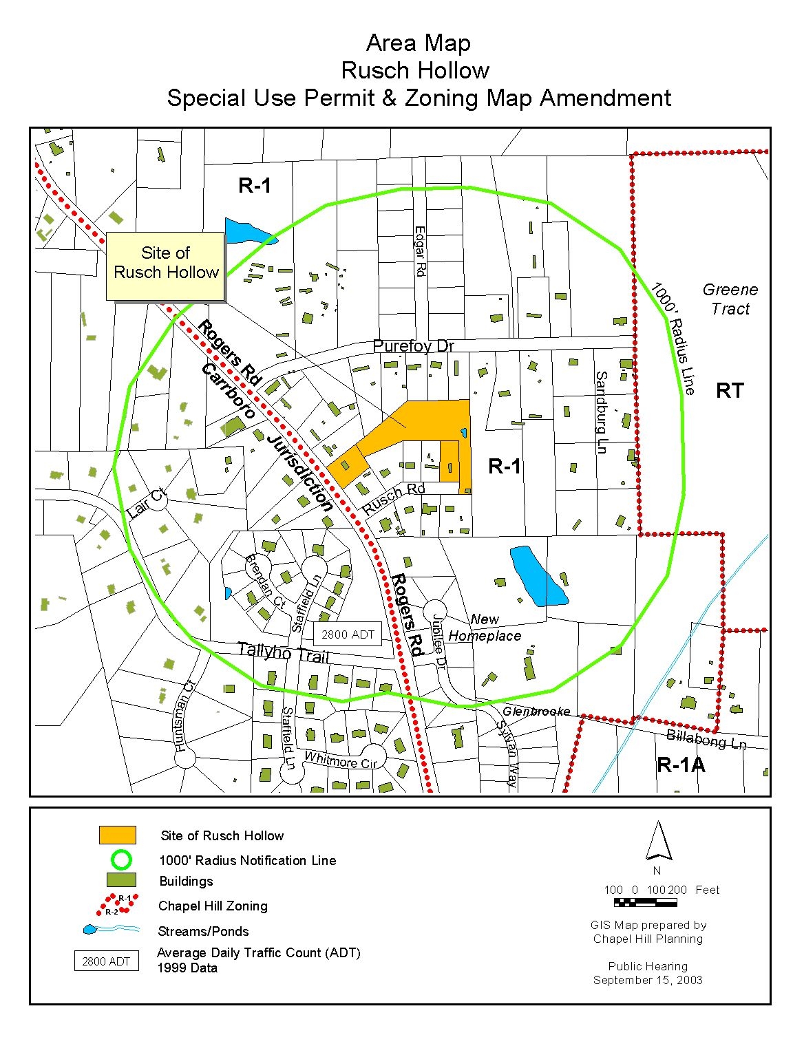