GREENWOOD
NEIGHBORHOOD CONSERVATION DISTRICT
PLAN
CD-2
Adopted by the Chapel Hill Town Council
June 12, 2006
Greenwood Neighborhood Conservation District
June 12, 2006
SUMMARY
This Greenwood Neighborhood Conservation District Plan has been prepared and adopted in accordance with Section 3.6.5 in Chapel Hill’s Land Use Management Ordinance, and has been incorporated into the Land Use Management Ordinance by reference.
The purpose of a Neighborhood Conservation District is to establish special regulations especially designed for and intended to help preserve the character of a particular, older residential neighborhood. This Plan contains special regulations for the Greenwood Neighborhood Conservation District (CD-2) as described below.
BOUNDARIES
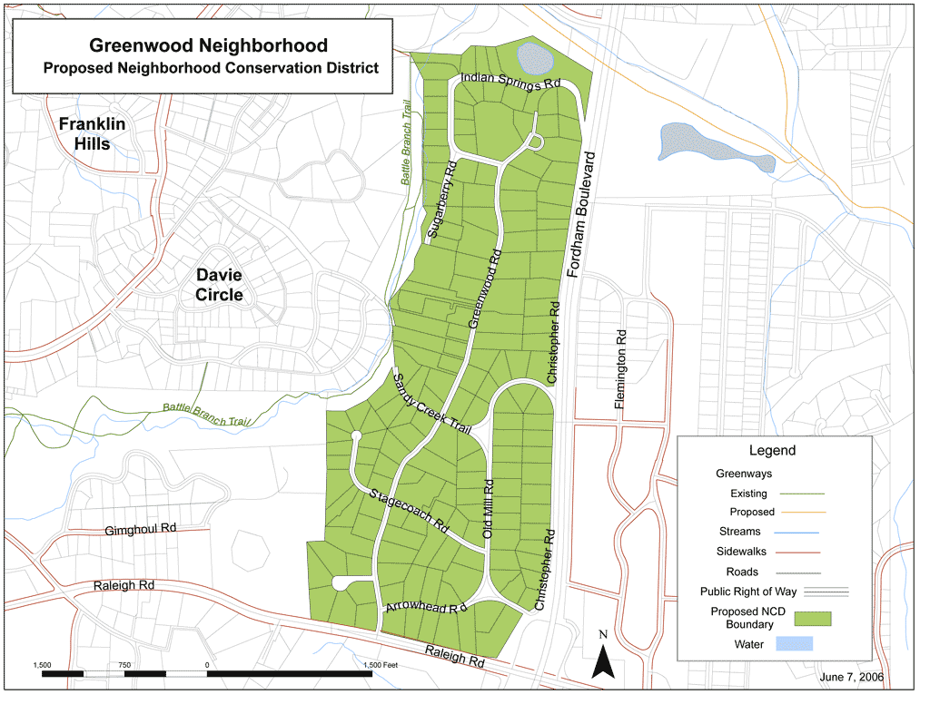
The boundaries of the Greenwood Neighborhood Conservation District generally are the northern boundary of lots fronting on Indian Springs Road to the north, Christopher Road and Fordham Boulevard to the east, Raleigh Road to the south, and a combination of Battle Branch and church properties to the west. Please see the attached map of the District boundaries. The boundaries shall be indicated on the official Zoning Atlas which accompanies the Land Use Management Ordinance.
SPECIAL DESIGN STANDARDS TO APPLY TO DEVELOPMENT
IN THE GREENWOOD CONSERVATION DISTRICT
The following Design Standards shall apply to all development within the Greenwood Conservation District, and are incorporated into Chapel Hill’s Land Use Management Ordinance by reference. No application for development shall be approved that does not comply with these standards. For the Greenwood Neighborhood Conservation District, these standards replace/supersede general provisions in the Land Use Management Ordinance where such standards differ. For standards that are not specifically identified in this Plan, provisions of the underlying zoning district for a particular parcel shall apply.
The standards for the Greenwood Neighborhood Conservation District are as follows:
Greenwood Neighborhood Conservation District Plan
|
Regulation |
Standard for Greenwood *
|
|
Minimum Lot Size
|
1 acre |
|
Minimum Street Setback |
50 feet
|
|
Minimum Interior and Solar Setbacks
|
20 feet |
|
Maximum Floor Area Ratio for Single-Family Dwelling (or Single-Family Dwelling with Accessory Apartment)
|
.15 |
|
Maximum Building Height |
Maximum primary building height of 29 feet, maximum secondary building height of 35 feet. |
|
Maximum Percent of Front Yard Used for Parking |
25% |
|
Accessory Apartments
|
No minimum lot size requirement. An accessory apartment can be permitted as part of any single-family dwelling regardless of lot size. |
|
Fences |
Except for the portion of lots that front on Christopher Road / Fordham Boulevard, the following standards shall apply: Fences located in the front yard ** and taller than 2.5 feet shall have openings of at least 50 percent or more in the construction of the fence. All fences located in the front yard, with street frontage, shall have a maximum fence height of 4 feet except where required by law for facilities such as swimming pools.
|
* For the Greenwood Neighborhood Conservation District, these standards replace/supersede general, otherwise applicable provisions in the Land Use Management Ordinance where such standards applicable to the property differ. For standards that are not specifically identified in this Plan, provisions of the underlying zoning district for a particular parcel shall apply.
** Front yard for this fence standard shall be the street the house faces.
ATTACHMENT
Map of Neighborhood Conservation District Boundaries