AGENDA #1
TO: Mayor and Town Council
FROM: W. Calvin Horton, Town Manager
SUBJECT: Public Hearing: Proposed Neighborhood Conservation District for the Greenwood Neighborhood
DATE: May 15, 2006
PURPOSE
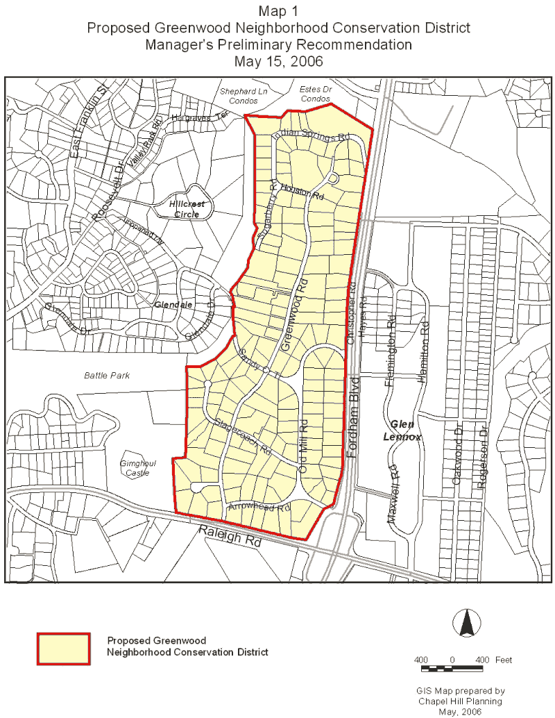
Tonight, the Council considers a proposed rezoning to create a Neighborhood Conservation District for the Greenwood neighborhood. An attached map shows the proposed boundary for the Neighborhood Conservation District (please see Map 1).
This package of material has been prepared for the Town Council’s consideration, and is organized as follows:
The Land Use Management Ordinance includes a provision for creating Neighborhood Conservation Districts. The purpose of creating a Neighborhood Conservation District is to preserve and protect unique and distinctive older in-town residential neighborhoods or commercial districts which contribute significantly to the overall character and identity of the Town.
A Neighborhood Conservation District is created as an overlay zoning district by enactment of an ordinance to designate the district. The rezoning ordinance would identify the designated district boundaries. The Land Use Management Ordinance also states that a conservation plan shall be approved as part of a Zoning Atlas Amendment creating a Neighborhood Conservation District.
On February 14, 2005, the Planning Board petitioned the Council to consider creating a Neighborhood Conservation District for the Greenwood neighborhood. This proposal was in response to the Board’s review of a proposed subdivision in the Greenwood neighborhood (that was subsequently withdrawn). On February 28, 2005, the Council received a report on a potential process for considering rezoning of the neighborhood after an additional subdivision application was submitted. In April 2005, the Council rezoned the Greenwood neighborhood to Residential-Low Density 1 (R-LD1 – 1 acre minimum lot size).
On June 15, 2005, the Council authorized engaging Clarion Associates to prepare and complete Neighborhood Conservation Districts in the Coker Hills, Greenwood, Morgan Creek/Kings Mill Road, and Pine Knolls neighborhoods by April 2006, at a cost not to exceed $50,000. Clarion presented its final recommendations to the Planning Board at its March 7, 2006 meeting. Please see Attachment 2 for the recommendations prepared by Clarion Associates for the Greenwood neighborhood. Please see the summary chart below for a table that summarizes the proposed Neighborhood Conservation District Plan recommendations.
ORDINANCE PROVISIONS
To be designated a Neighborhood Conservation District, the Land Use Management Ordinance states that an area must meet the following criteria:
The area must possess one or more of the following distinctive features that create a cohesive identifiable setting, character or association;
According to the Land Use Management Ordinance, a proposal for designation as a Neighborhood Conservation District may be initiated in one of three ways:
In the case of the Greenwood neighborhood, the Council initiated the process by adopting a resolution on June 15, 2005.
The following provides a summary of the recommendations as proposed by Clarion Associates and preliminary recommendations from the Manager.
Minimum Lot Size: The Greenwood neighborhood is currently zoned Residential-Low Density 1 (R-LD1), which requires a one acre minimum lot size (43,560 square feet). The Clarion Associates recommendation does not include a change to the current regulations.
Preliminary Recommendation: We recommend maintaining the current minimum lot size of one acre. Existing lots below the one acre minimum lot size are currently nonconforming lots. Please refer to Attachment 4 for a discussion of nonconforming status. In most circumstances, the status of a lot as nonconforming poses no negative impacts for a single-family residential property owner. The effect of nonconforming lot status occurs when multiple, adjacent lots are held in common ownership and one or more is nonconforming. Chapel Hill’s Land Use Management Ordinance contains the following language:
“Where a nonconforming lot abuts another lot of record (whether conforming or nonconforming) held in the same ownership at or subsequent to enactment of this Chapter, such lots shall be combined or recombined as necessary to form a conforming lot or lots and shall not thereafter be subdivided except in compliance with all of the requirements of this Chapter.”
The Ordinance provisions allow construction of a new house on a lot smaller than one acre unless a property owner owns the lot next door. The Ordinance provisions would not allow construction of a new house on a lot smaller than one acre if the same owner owns the property next door, unless the two lots can be recombined to create two lots with at least one acre each.
Minimum Street Setback: The current R-LD1 zoning requires a minimum street setback of 30 feet. The Clarion Associates recommendation is to change the minimum street setback to 50 feet.
Preliminary Recommendation: We recommend increasing the minimum street setback to 50 feet. Existing lots that do not meet this regulation would become lots with nonconforming features. Please refer to Attachment 4 for a detailed discussion of nonconforming status. We do not believe that many nonconformities would be created. This determination is difficult to make without a survey of each property. The regulations provide a special status if a home no longer complies with the setback regulations that allow the structure to be rebuilt if damaged or destroyed.
Minimum Interior Setback: R-LD1 zoning requires a minimum interior setback of 16 feet. The Clarion Associates recommendation is to change the interior setback to 20 feet.
Preliminary Recommendation: We recommend increasing the minimum interior setback to 20 feet. The Chapel Hill Land Use Management Ordinance distinguishes between an interior setback and a solar setback, which in R-LD1 zoning is 19 feet. We believe that the Clarion recommendation refers to both setbacks. We support the increase of both to 20 feet. Please refer to Attachment 4 for a detailed discussion of nonconforming status. The regulations provide a special status if a home no longer complies with the setback regulations that allow the structure to be rebuilt if damaged or destroyed.
Maximum Floor Area Ratio: The current R-LD1 zoning does not apply a floor area ratio to single-family homes. We note that this type of regulation was included in the Northside Neighborhood Conservation District. The Clarion Associates recommendation is to impose a floor area ratio of 0.15. The recommendation allows for larger single-family dwellings if they meet the proposed floor area ratio (.15) and if required minimum street and interior setbacks are doubled.
Preliminary Recommendation: We recommend the creation of a floor area ratio of .15 as proposed.
Maximum Building Height: The current R-LD1 zoning permits a maximum primary building height of 29 feet and a maximum secondary building height of 35 feet. The Clarion Associates recommendation is to change the building height to a limit of two (2) stories and an unfinished attic, above the level of the street. The recommendation maintains the secondary building height at 35 feet.
Preliminary Recommendation: We do not recommend the proposal to change the maximum building height language to “stories” instead of a quantifiable measurement of feet. From a regulatory standpoint, we believe that defining the word “stories” and evaluating an application based on stories instead of feet introduces a subjective element to the zoning permit process. We recommend maintaining the current R-LD1 zoning standards for maximum primary and secondary building height.
Maximum Percentage of Front Yard Used for Parking: Section 5.9.9 of the Land Use Management Ordinance states that parking and drive areas shall be limited to 40 percent of the front yard area of any zoning lot. This restriction applies to single-family and two-family residences. The Clarion Associates recommendation is to change the percentage of front yard parking to 25 percent.
Preliminary Recommendation: We recommend the proposal to decrease the percentage of allowable front yard parking area to 25 percent. Given the larger lot sizes in the neighborhood, we believe a provision to allow up to 25 percent of a front-yard to be provided as parking is appropriate.
Accessory Dwelling Units: The recommendation from Clarion Associates includes a provision that no additional minimum lot size would be required to develop an accessory apartment, and that an accessory apartment is permitted with every single-family dwelling.
Preliminary Recommendation: We also recommend the proposal that no additional lot size be required for an accessory dwelling unit.
Fences: The Land Use Management Ordinance does not restrict building fences that are below six feet in height. Fences taller than six feet are not allowed to be built inside the setbacks as defined by the zoning district. The Clarion Associates recommendation would require fences in the front yard that are taller than 2.5 feet to be no more than 50 percent opaque. All fences located in the front yard, with street frontage, would have a maximum fence height of 4 feet.
Preliminary Recommendation: We also recommend the restriction of fences as proposed by Clarion. We believe that this regulation would address concerns raised by residents of the neighborhood.
Single Family Zoning Compliance Permit Notification: The Town currently does not have a notification requirement for a Zoning Compliance Permit. Clarion’s recommendations would require property owners that wish to apply for a Zoning Compliance Permit be notified if an increase in floor area or garages are proposed. A ten-day waiting period would follow notification.
Preliminary Recommendation: We do not recommend the proposal to require notification of a Zoning Compliance Permit. We believe this recommendation places a burden on property owners. To send notification through the Town, a resident would have to purchase the addresses of adjacent property owners from the Orange County Database or present evidence that they have included the addresses of adjacent property. They would also be required to provide stamped, pre-addressed envelopes to the Town so that adjacent property owners could be notified of a proposed Zoning Compliance Permit, and observe a ten-day wait period before taking any action. A ten-day wait period is not required by the Town for any other activity. We are concerned that this recommendation would present administrative challenges for enforcement, also.
Tree Protection: The Land Use Management Ordinance does not currently address the issue of Tree Protection for a single- or two-family dwelling. Clarion Associates’ recommendation requires consultation with Town staff before removing deciduous trees measured at 24” DBH (diameter at breast height) or greater, except as part of construction and/or maintenance of permitted improvements, or to remove dead, diseased or hazardous trees.
Preliminary Recommendation: We are concerned about the recommendation to require consultation with Town staff before clearing trees measured at 24” DBH. We believe the addition of tree protection regulations for single- and two-family dwellings could have significant staffing implications. In addition, the Council is considering a text amendment to the Land Use Management Ordinance to address this issue Town-wide. We recommend that tree removal issues be addressed during the Council’s deliberations on this matter, expected later this year.
Neighborhood District Boundary: The Clarion Associates recommendation states that the boundary of the neighborhood has been an open discussion throughout the process, with specific concerns about the inclusion of the eight UNC-owned properties located on the southern end of Greenwood Road and the large property located at the northern end of Indian Springs Road. Residents who attended the meetings support inclusion of the UNC owned properties even though state-owned property is not subject to overlay district regulations. However, if the property was sold to a non-state owned entity, the properties would be required to comply with new regulations. The property owner at the northern end of Indian Springs Road has requested that this property be excluded from the district boundary. Residents of the neighborhood have requested inclusion of the property.
Preliminary Recommendation: We recommend inclusion of the UNC owned properties and the property at the northern end of Indian Springs Road in the Neighborhood Conservation District boundary. We believe the decision to include these two areas should be based on principles that are fair, objective, and will help guide boundary issues in the development of future Neighborhood Conservation Districts. We believe that a critique of the UNC owned properties and the property at the northern end of Indian Springs Road against the criteria in the Land Use Management Ordinance supports the inclusion of the properties. The properties contains one block face; the area was developed over 25 years ago; at least 75 percent of the land area in the proposed district is presently improved; and the area possesses one or more distinctive features that create a cohesive identifiable setting, character or association.
The Greenwood Neighborhood Conservation District is proposed as a Zoning Atlas Amendment. The Land Use Management Ordinance requires the Town Manager to: 1) conduct an evaluation of the proposed rezoning; 2) present a report to the Planning Board; 3) notify property owners of the proposal; 4) hold a public hearing; and 5) present a report and recommendation to the Town Council.
Public Notice
On April 26, 2006, notice of the public hearing was sent to the property owners and owners of property within 1,000 feet of the properties proposed for rezoning (please see Attachment 3). Notice of the proposed rezoning was also included in the Town Week section of the Chapel Hill News on Sunday, April 30, and Sunday, May 7. Copies of the agenda materials for the proposed rezoning are available in the Town Clerk’s office. Documents are also available on the Town’s website (www.townofchapelhill.org).
Format Tonight
The Council is holding a public hearing to receive citizen comment on a proposed rezoning. Typically, the Council refers comments made at the public hearing to the Manager and Town Attorney for a follow-up report. We anticipate returning to the Council with a follow up report for consideration on June 12, 2006.
Protest Petitions
By law, formal “Protest Petitions” may be filed against this rezoning. A formal Protest Petition that meets legal requirements would increase the number of votes needed to enact this rezoning. The notice mailed on April 26, 2006 included a statement that information on protest petitions was available from the Town Clerk or the Planning Department. If a protest petition is submitted and determined to be valid, a three-fourths vote by the Council would be required to enact the new zoning. The deadline for filing protest petitions with the Town Clerk was Wednesday, May 10, 2006. We will report at tonight’s Public Hearing regarding any valid protest petitions that have been submitted.
Zoning determines the type and intensity of uses and development that are allowed on a piece of land. In Chapel Hill, a rezoning may be requested in two ways: general use and conditional use rezoning requests. A general use rezoning request is to change the zoning to a different zoning district in which any of several kinds of developments and uses are permissible. A conditional use rezoning request is to allow development and uses only with approval of a Special Use Permit. The Greenwood neighborhood rezoning proposal is a general use rezoning. The designation would be as an overlay zone.
The zoning designation of a property determines the range of land uses and development intensities permitted on the property. Article 4.4 of the Land Use Management Ordinance establishes the intent of Zoning Atlas Amendments by stating:
“In order to establish and maintain sound, stable, and desirable development within the planning jurisdiction of the Town it is intended that this Chapter shall not be amended except a) to correct a manifest error in the Chapter; or b) because of changed or changing conditions in a particular area or in the jurisdiction generally; or c) to achieve the purposes of the Comprehensive Plan.
It is further intended that, if amended, this Chapter be amended only as reasonably necessary to the promotion of the public health, safety, or general welfare, and in conformance with the Comprehensive Plan.”
Comprehensive Plan
Land Use Plan
The entire area proposed for rezoning is designated as Low Residential (1-4 units/acre) on the Chapel Hill Land Use Plan, adopted May 8, 2000. Residential-Low Density 1 zoning districts are consistent with this land use designation.
Residential Conservation Areas
The area proposed for rezoning is designated as a “residential conservation area” in Figure 2 of the Town’s Comprehensive Plan. The Comprehensive Plan designates certain areas surrounding the downtown and University of North Carolina campus as “residential conservation areas” because they are considered to be particularly susceptible to change. This designation means, in part, that when policy choices that affect these areas are before the Town Council, the balance should tilt in favor of protection and preservation.
Zoning Justification
As noted in the “Zoning Atlas Amendments” section of this memorandum, there are three justifications for rezonings: a) to correct a manifest error in the chapter; or b) because of changed or changing conditions in a particular area or in the jurisdiction generally; or c) to achieve the purposes of the Comprehensive Plan. Only one justification needs to be met in order for the Council to approve a rezoning.
Following is a response to the three required considerations:
A. A rezoning is necessary to correct a manifest error.
We do not believe that the current Residential-Low Density 1 zoning of this site is a manifest error.
B. A rezoning is necessary because of changed or changing conditions in a particular area or in the jurisdiction generally.
We do not believe that this rezoning is necessary because of changed or changing conditions in the area or in the jurisdiction generally.
C. A rezoning is necessary to achieve the purposes of the Comprehensive Plan.
Argument in Support: As noted above, the Comprehensive Plan identifies the area as a “residential conservation area”. Because of its proximity to the downtown and the main campus of the University, it is reasonable to believe that the Greenwood neighborhood may be affected by growth pressures related to the demand for housing.
We believe creating a Neighborhood Conservation District for the Greenwood neighborhood is consistent with the following Comprehensive Plan policies:
As noted above, the area is one of the “residential conservation areas” identified on Figure 2 of the Comprehensive Plan. The area is characterized by larger lots, and lots are dominated by woodland and tree stands. We believe that these homes and their settings have a cohesive character that is worth preserving. As noted above, the proposed rezoning is also consistent with the proposed area’s designation of Low Residential (1-4 units/acre) on the Town’s Land Use Plan.
Arguments in Opposition: Section 7.2 of the Comprehensive Plan contains an objective to “establish policies, regulations, incentives and programs to promote the availability of a full range of housing types, densities, costs, and tenancy options in Chapel Hill, both within new developments and existing neighborhoods.” It could be argued that creating a Neighborhood Conservation District in Greenwood may limit the potential for a variety of housing types and sizes.
Evaluation of Neighborhood Conservation District Plan
As described above, the proposed changes to the underlying zoning district is intended to meet the goals of the 2000 Comprehensive Plan to protect and preserve neighborhoods affected by their central location near the heart of Town.
In addition, the changes are intended to alter the allowable “building envelope” to result in buildings which fit into the fabric of the neighborhood and be compatible with surrounding development. If the overlay zoning provisions are adopted, the scale and massing of future development would be more in keeping with the existing character of the neighborhood.
When considering rezoning a property or properties in this case, one factor to be considered is the effect the rezoning may have on existing uses in the area, as well as any “nonconformities” that may result from the rezoning. Generally, the term “nonconforming” refers to lots, uses, or features that complied with regulations at the time the use or structure began, but which do not meet current regulations. Nonconforming uses and features are allowed to be reconstructed if damaged or destroyed. Attachment 4 contains an explanation of nonconformities.
Nonconforming Lot: In April 2005, the Council rezoned the Greenwood neighborhood to Residential-Low Density 1 (R-LD1). The minimum lot size for this zoning district is one acre. The proposed recommendations for a Neighborhood Conservation District include continuing a 1 acre minimum lot size. Currently 67 of the 163 lots in the neighborhood are nonconforming lots because they do not meet the minimum lot size.
For almost all circumstances, the status of a lot as a nonconforming lot poses no negative impacts for a single family residential property owner. If a nonconforming lot is vacant, the owner can still build a single family house. If a single family house already exists on a nonconforming lot, the house can be used, expanded, and rebuilt if destroyed. The impact of nonconforming lot status occurs when multiple, adjacent lots are held in common ownership and one or more is nonconforming. In keeping with State Statutes, Chapel Hill’s Land Use Management Ordinance contains the following language: “Where a nonconforming lot abuts another lot of record (whether conforming or nonconforming) held in the same ownership at or subsequent to enactment of this Chapter, such lots shall be combined or recombined as necessary to form a conforming lot or lots and shall not thereafter be subdivided except in compliance with all of the requirements of this Chapter.”
Nonconforming Use: A nonconforming use is a land use that does not conform to the Land Use Management Ordinance regulations. We are not aware of any nonconforming uses that would be created as a result of the Neighborhood Conservation District.
Nonconforming Feature: A nonconforming feature is a physical characteristic that does not conform to today’s setback, height or other intensity or design provisions of the Ordinance. Nonconforming features for existing development may continue to exist and may be reconstructed if the structure was damaged or destroyed. If enacted, the proposed Neighborhood Conservation District could result in the creation of nonconforming features.
RECOMMENDATIONS
Planning Board Recommendation: On March 7, 2006, the Planning Board voted to recommend a Neighborhood Conservation District for the Greenwood neighborhood as described in the attached Summary of Planning Board Action (please see Attachment 5) and outlined in the summary chart below.
Manager’s Preliminary Recommendation: We believe that creating a Neighborhood Conservation District for the Greenwood neighborhood is consistent with the Comprehensive Plan and the Land Use Management Ordinance, and therefore, recommend that the Council enact the attached Ordinance approving the proposed Zoning Atlas Amendment.
Following tonight’s Hearing, we will complete a Neighborhood Conservation District Plan for the Greenwood Neighborhood. The Neighborhood Conservation District Plan would detail the guidelines for the Neighborhood Conservation District and the boundary. The Plan would be incorporated as a part of the Land Use Management Ordinance, and would be subject to modification in the same manner as any other amendment to the Zoning Atlas.
The Plan will be prepared following the opening of the Public Hearing tonight, and will be presented when the Hearing is continued at the time this returns for Council consideration.
Summary of Recommendations
for the Greenwood Neighborhood
Neighborhood Conservation District Plan
|
Current Zoning |
Clarion Associates Recommendation |
Manager’s Preliminary Recommendation |
Planning Board Recommendation |
Summary of Citizen Comments |
|
|
1. Minimum Lot Size |
1 acre |
1 acre |
1 acre |
1 acre |
Some concern was raised about the existing nonconforming lots and some supported a .75 minimum lot size. |
|
2. Minimum Street Setbacks for Single-Family Dwelling (or Single-Family Dwelling with Accessory Apartment) |
30 feet |
50 feet |
50 feet |
50 feet |
Some residents felt the current setback of 30 feet should be maintained and some suggested a 75 foot setback. |
|
3. Minimum Interior Setbacks for Single-Family Dwelling (or Single-Family dwelling with Accessory Apt) |
16 feet, 20 feet northern interior |
20 feet |
20 feet |
20 feet
|
There was some support for maintaining the current setback of 20 feet. |
|
Land Use Regulation |
Current Zoning |
Clarion Associates Recommendation |
Manager’s Preliminary Recommendation |
Planning Board Recommendation |
Summary of Citizen Comments |
||
|
4. Maximum Floor Area Ratio for Single-Family Dwelling (or Single-Family Dwelling with Accessory Apartment) |
N/A |
.15 |
.15 |
.15 |
Some felt that this would allow for development of houses too large for the neighborhood and that .1 might be more reasonable. |
||
|
5. Maximum Building Height |
Maximum primary building height of 29 feet, maximum secondary height of 35 feet |
Limit to 2 stories and an unfinished attic, above the level of the street. Maximum secondary building height as currently defined in Land Use Management Ordinance to be maintained at 35 feet |
Maximum primary building height of 29 feet, maximum secondary height of 35 feet |
Maximum primary building height of 29 feet, maximum secondary height of 35 feet |
Some residents supported a 40 feet maximum height standard and no story limitation. |
||
|
6. Maximum Percent of Front Yard Used for Parking |
40% |
25% |
25% |
25% |
Some felt this was unnecessary because not an issue in the neighborhood. Some felt 10-15% was more reasonable |
||
|
7. Accessory Apartments |
Permitted with a 2 acre minimum lot size |
No additional minimum lot size requirement |
No additional minimum lot size requirement |
No additional minimum lot size requirement |
A resident suggested that accessory dwelling units be allowed on lots more with 1.5 acres. |
||
Land Use Regulation |
Current Zoning |
Clarion Associates Recommendation |
Manager’s Preliminary Recommendation |
Planning Board Recommendation |
Summary of Citizen Comments |
|
|
8. Fences |
No restrictions on fences below six feet in height |
Fences located in the front yard and taller than 2.5 feet shall be no more than 50% opaque. All fences located in the front yard, with street frontage, shall have a maximum fence height of 4 feet. |
Fences located in the front yard and taller than 2.5 feet shall be no more than 50% opaque. All fences located in the front yard, with street frontage, shall have a maximum fence height of 4 feet. |
Fences located in the front yard and taller than 2.5 feet shall be no more than 50% opaque. All fences located in the front yard, with street frontage, shall have a maximum fence height of 4 feet. |
Fences higher than 4 feet may be needed on Christopher Road because of Fordham Blvd. Fences should be permitted on Raleigh Road too.
|
|
|
9. Single-Family Zoning Compliance Permit Notification |
No notification required |
Adjacent property owners must be notified through the Town if an increase in floor area or garages are proposed, with a 10-day waiting period to follow notification |
No change to current regulations |
No change to current regulations |
Some residents felt that this provision was unnecessary and does not provide enforceable protection. |
|
|
Land Use Regulation |
Current Zoning |
Clarion Associates Recommendation |
Manager’s Preliminary Recommendation |
Planning Board Recommendation |
Summary of Citizen Comments |
|
10. Tree Protection |
No current regulations for single or two-family dwelling |
Require consultation with Town before clearing deciduous trees measured at 24” DBY or greater, except as part of construction and/or maintenance of permitted improvements, or to remove dead, diseased, or hazardous trees. |
No change to current regulations |
No change to current regulations |
Some residents stated that trees are a significant part of the neighborhood and that there should be tree protection provisions. A citizen commented that something should be done to restrict tree removal in the setbacks. |
|
11. Boundary |
|
Include property on Indian Springs Road and eight UNC-owned properties on Greenwood Road |
Include property on Indian Springs Road and eight UNC-owned properties on Greenwood Road |
Include property on Indian Springs Road and eight UNC-owned properties on Greenwood Road |
Include property on Indian Springs Road and eight UNC-owned properties on Greenwood Road. A property owner on Indian Springs Rd. requested exclusion from the boundary. |
May 15, 2006
MAP