|
TO: |
Roger L. Stancil, Town Manager |
|
FROM: |
J.B. Culpepper, Planning Director Gene Poveromo, Development Coordinator |
|
SUBJECT: |
Public Hearing: Chapel Watch Village – Application for Special Use Permit (File No. 9870-87-1493) |
|
DATE: |
April 16, 2006 |
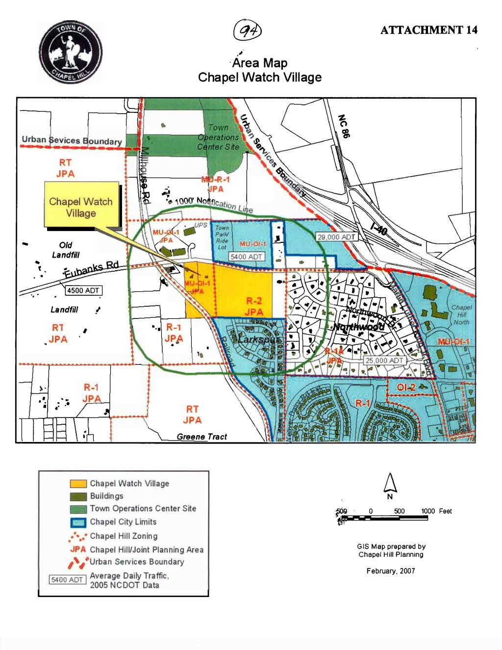
Attached for your consideration is a proposal for a multi-family development with 120 units and 189 parking spaces. The 35-acre site is located on the south side of Eubanks Road, opposite the Eubanks Road Park and Ride Lot and adjacent to the Larkspur neighborhood. The site is located in the Residential-1 (R-1), Residential-2 (R-2), and the Mixed-Use Office/Institutional-1 (MU OI-1) zoning districts and the Joint Planning Area and is identified as Orange County Parcel Identifier Numbers 9870-87-1493, 9870-87-5224, and 9870-97-1299.
|
This package of materials has been prepared for the Town Council’s consideration, and is organized as follows:
|
Tonight’s Public Hearing has been scheduled to receive evidence in support of and in opposition to approval of the application, as the Council determines the appropriate requirements to include as conditions of approval.
On March 17, 2003, the Town Council reviewed a Concept Plan for Chapel Watch Village. On May 5, 2003, the Town received and accepted an application for a Special Use Permit for the Chapel Watch Village project. In 2005, the applicant informed the staff about proposed changes to the plan and a desire to return to the Concept Plan Review process. On May 16, 2005, the Town Council reviewed a revised Concept Plan for the proposed development. Because there was an active Special Use Permit application on file at that time, the May 16, 2005 Concept Plan Review by the Town Council was quasi-judicial. At the conclusion of the meeting, the Council referred the Concept Plan to the Transportation Board for comment on connectivity between the proposed development and the Larkspur Subdivision.
On September 26, 2005, the Council received comments from the Transportation Board. The Council referred questions from the September 26 Concept Plan review to the staff and continued the review to November 21, 2005. At the November 21, 2005 meeting, the Council recommended that the applicant’s Special Use Permit application include plans with and without a connection to the Larkspur neighborhood. The Council voted unanimously to transmit comments on the Concept Plan to the applicant. A copy of the November 21, 2005 Minutes are attached (Attachment 8).
The Special Use Permit application proposal is to construct 21 buildings, including 120 dwelling units. The applicant is proposing to provide a pool, clubhouse, tot lot, a portion of the “Horace Williams Trail” (aka Rail to Trails), and a five-foot-wide sidewalk along Eubanks Road. The applicant is proposing to provide 189 parking spaces, of which 148 would be garage spaces. Five bio-retention basins are proposed. The proposal also includes a central refuse and recycling facility with a compactor and recycling containers.
The applicant is proposing that 18 of the 120 units (15 percent) would be permanently affordable rental units reserved for those making up to 80 percent of the area median income and will be provided in coordination with the Orange Community Housing and Land Trust organization.
The Land Use Management Ordinance requires the Town Manager to conduct an evaluation of this Special Use Permit application, to present a report to the Planning Board, and to present a report and recommendation to the Town Council. We have reviewed the application and evaluated it against Town standards; we have presented a report to the Planning Board; and tonight we submit our report and preliminary recommendation to the Council.
The standard for review and approval of a Special Use Permit application involves consideration of four findings (description of the findings follows below). Evidence will be presented tonight. If, after consideration of the evidence, the Council decides that it can make each of the four findings, the Land Use Management Ordinance directs that the Special Use Permit shall then be approved. If the Council decides that the evidence does not support making one or more of the findings, then the application cannot be approved and, accordingly, should be denied by the Council.
We have evaluated the application regarding its compliance with the standards and regulations of the Town’s Land Use Management Ordinance. Based on our evaluation, our preliminary conclusion is that the application as submitted complies with the regulations and standards of the Land Use Management Ordinance and Design Manual, with the conditions included in Resolution A.
Tonight, the Council receives our attached evaluation and information submitted by the applicant and citizens. The applicant’s materials are included as attachments to this memorandum. All information that is submitted at the hearing will be included in the record of the hearing.
Based on the evidence that is submitted, the Council will consider whether or not it can make each of four required findings for the approval of a Special Use Permit.
The four findings are:
|
Special Use Permit – Required Findings of Fact
Finding #1: That the use or development is located, designed, and proposed to be operated so as to maintain or promote the public health, safety, and general welfare;
Finding #2: That the use or development would comply with all required regulations and standards of the Land Use Management Ordinance;
Finding #3: That the use or development is located, designed, and proposed to be operated so as to maintain or enhance the value of contiguous property, or that the use or development is a public necessity; and
Finding #4: That the use or development conforms to the general plans for the physical development of the Town as embodied in the Land Use Management Ordinance and in the Comprehensive Plan. |
Following the Public Hearing, we will prepare an evaluation of the evidence submitted in support of and in opposition to this application.
We have identified five key issues associated with this development: 1) Connectivity to the Larkspur neighborhood; 2) Maintenance of the Horace Williams Trail (aka Rails to Trails); 3) Recreation space requirements; 4) Landscape buffers adjacent to the east property line; and 5) Energy Efficiency.
1. Connectivity to the Larkspur neighborhood: Vehicular and pedestrian connections between the proposed development and the Larkspur neighborhood have been a central point of discussion throughout the review of this application. The Developer’s Program from the Chapel Watch Village Concept Plan proposal of January 31, 2005 states that “Larkspur was developed on the basis that a public road corridor would proceed northward through this subject property, connecting Larkspur to Eubanks Road.” In 2002, the Council approval of the subdivision plans for the Larkspur neighborhood included a stub-out to the north, to provide a connection to future development at the Chapel Watch Village site.
The applicant’s current proposal includes the dedication of a 45-foot-wide public right-of-way, between the proposed development and the Larkspur neighborhood, with an emergency access only connection to Larkspur.
Staff Comment: Based on the results of the Traffic Impact Analysis and studies of connectivity, we believe that providing a vehicular connection between Chapel Watch Village and Maywood Way in the Larkspur neighborhood would allow for greater access for the two neighborhoods. We believe that the volume of cut-through traffic can be minimized and the speeds can be controlled through traffic calming measures. We recommend that the Council approve the application with the following stipulations:
Public Street Connection to Maywood Way: That the plan include a full-access public street connection between Eubanks Road and the Larkspur neighborhood. This public street shall be constructed to Town standards with a width of 27 feet from back of curb to back of curb, 2.5-foot curb and gutter, including a sidewalk on one side, and with the dedication of a 45-foot public right-of-way for the street.
Traffic Calming: That at such time that a full access public street between Eubanks Road and Maywood Way in the Larkspur neighborhood is constructed and open, the applicant shall construct traffic calming devices (near the southern entrance to the Chapel Watch Village project) and that the applicant shall also construct traffic calming devices within the Larkspur neighborhood. The location, number and type of traffic calming devices installed shall be subject to the approval of the Town Manager prior to the issuance of a Zoning Compliance Permit. That if full access between the Chapel Watch Village and Larkspur neighborhoods is delayed beyond the issuance of the first Certificate of Occupancy, the Town Manager may require that the applicant provide a payment-in-lieu for future traffic calming devices, prior to the issuance of a Zoning Compliance Permit.
Providing street connections between neighborhoods diffuses traffic throughout the Town, reducing congestion, and the demand for the widening of arterials (as well as the desire of drivers to speed on the non-local roads). In addition to supporting the broader Town wide goals for access and mobility, connectivity provides a more efficient means for provision of services such as mail delivery, fire, police, and public works. Also, providing another access point for the Larkspur neighborhood would avoid a situation of “no access” if a potential blockage of the existing access were to occur (such as a traffic accident).
The Planning Board recommendation supported the applicant’s proposal for a public right-of-way with emergency access only connection to Larkspur. For Council consideration, we offer the option recommended by the Planning Board and the applicant:
Emergency Access only (within a dedicated public right-of-way): That the portion of the internal street between Eubanks Road and the Larkspur neighborhood, beyond the southernmost units, be designed as emergency access only with bollards at the Maywood Way stub-out to allow for pedestrian and bicycle connectivity, as proposed by the applicant, and be located within a 45-foot-wide public right-of-way dedicated to the Town of Chapel Hill. That opening the entire roadway as a full access street to the Larkspur neighborhood shall require a public hearing process involving notification of all property owners within the Chapel Watch and Larkspur neighborhood.
2. Maintenance of the Horace Williams Trail (aka Rails to Trails): The staff report to the advisory boards included a recommendation that the applicant construct and maintain the portion of the Horace Williams Trail between Larkspur and Eubanks Road, as shown on the Greenways Master Plan. During the Planning Board’s meeting the applicant expressed opposition to this recommendation. The Planning Board recommendation to the Council included a condition that the Town is responsible for maintaining the trail.
Staff Comment: We believe that Town maintenance of the greenway is reasonable and is a public service that benefits the entire community. We have incorporated the recommendation from the Planning Board for Town maintenance of the greenway into Resolution A.
3. Recreation space requirements: The Land Use Management Ordinance includes a provision that allows a development to satisfy all or a portion of its recreation space requirements, if the proposed development includes the construction of a greenway that is part of the Town’s Greenway Master Plan. Because the greenway construction proposed by the applicant is part of the Town’s “Horace Williams Trail,” the applicant is proposing that 21,600 square feet of land area associated with this greenway be credited towards the required recreation space for this development.
The Planning Board recommended that, because the applicant is not willing to maintain the greenway, the square footage of the greenway that may be credited towards satisfying the applicant’s recreation space requirements should be reduced by 50 percent.
Staff Comment: We concur with the recommendation of the Planning Board and have incorporated their recommendation into Resolution A.
One consequence of reducing the credited recreation space associated with the proposed greenway is that the applicant’s proposal does not meet the minimum recreation space requirement. We recommend that the applicant’s final plan application either provided the minimum recreation space or a payment-in-lieu of providing a minimum recreation space for this development. We have incorporated this recommendation into Resolution A.
4. Landscape buffers adjacent to the east property line: At the Planning Board meeting, citizens from the Northwood neighborhood expressed some concerns about ambient light, the potential visibility of headlights from cars in Chapel Watch Village, and general screening of the Chapel Watch Village buildings. The applicant has provided additional detail to the neighborhood and to staff as to how they will achieve the required Type ‘B’ buffer with screening that specifically addresses the Northwood neighbors’ concerns.
Staff Comment: We recommend that the applicant provide the required Type ‘B’ buffer as proposed, and that specific plantings include those provided in “Planting Detail for Eastern Boundary Buffer” (Attachment 7).
5. Energy Efficiency: The staff’s recommendation to the advisory boards included a stipulation that requires the applicant to submit energy models showing a minimum energy efficiency savings of 20 percent relative to ASHRAE (American Society of Heating, Refrigeration and Air Conditioning Engineers) Standard 90.1-2004. The applicant has stated that this standard is intended to apply to rezoning applications and requested that the stipulation be removed.
Staff Comment: Subsequent to the writing of this memorandum, the Town Council was scheduled to discuss adopting an updated policy, during the April 11, 2007 meeting, specifying the Council’s expectations for energy efficiency and an energy management plan for applicants seeking approval of conditional use rezoning applications. This proposed development does not involve a rezoning application. We have removed the energy efficiency stipulation from Resolution A.
We have attached a resolution that includes standard conditions of approval as well as special conditions that we recommend for this application. With these conditions, our preliminary recommendation is that the Council could make the four findings necessary in order to approve the application. Our recommendation, Resolution A, incorporates input from all Town departments involved in review of the application.
Planning Board: The Planning Board met on April 3, 2007 and voted 5-4 to recommend that the Council approve the Special Use Permit with the following changes to stipulations:
1. Connectivity to the Larkspur neighborhood: That the connection to the Larkspur neighborhood is designed for pedestrian and emergency access only.
Comment: Please refer to the Key Issues section for additional discussion on this item.
2. Maintenance of the Horace Williams Trail: That the Town be responsible for the maintenance of the “Horace Williams” greenway.
Comment: Please refer to the Key Issues section for additional discussion on this item.
3. Recreation space requirements: That the portion of the recreation space associated with the “Horace Williams” greenway shall be reduced by 50 percent.
Comment: Please refer to the Key Issues section for additional discussion on this item.
4. Energy Efficiency: The applicant stated that the ASHRAE (American Society of Heating, Refrigeration, and Air Conditioning Engineers) standard in the staff recommended stipulation only applies to buildings greater than three stories in height.
Comment: Please refer to the Key Issues section for additional discussion on this item.
5. Land Disturbance in the Resource Conservation District: That the resolution is amended to clarify the anticipated amount of land disturbance in the Resource Conservation District
Comment: The applicant indicated that the resolution before the Planning Board states that there will be approximately 37,161 square feet of land disturbance in the RCD. A more accurate figure would be closer to 55,970 square feet. The applicant also requested that the stipulation be revised to note that a portion of the stormwater facilities will encroach into the Resource Conservation District. We have incorporated this change into Resolution A.
Transportation Board: The Transportation Board will meet on April 12, 2007. We will provide the Council with a Summary of the Transportation Board Action when it is available.
Community Design Commission: The Community Design Commission will meet on April 18, 2007. We will provide the Council with a Summary of the Community Design Commission Action when it is available
The Parks and Recreation Commission: The Parks and Recreation Commission will meet on April 18, 2007. We will provide the Council with a Summary of the Parks and Recreation Commission Action when it is available.
Bicycle and Pedestrian Advisory Board: The Bicycle and Pedestrian Advisory Board will meet on April 24, 2007. We will provide the Council with a Summary of the Bicycle and Pedestrian Advisory Board Action when it is available.
Greenways Commission: The Greenways Commission will meet on April 25, 2007. We will provide the Council with a Summary of the Greenways Commission Action when it is available.
Based on our evaluation of the Special Use Permit application, our preliminary conclusion is that, with the stipulations in Resolution A, the application complies with the standards and regulations of the Land Use Management Ordinance.
Following tonight’s Public Hearing, we will prepare an evaluation of the evidence submitted in support of and in opposition to this application. If the Council makes the required findings for approval of the Special Use Permit, we recommend that the application be approved with the adoption of Resolution A.
Resolution B would deny the application.
Differences Between Recommendations
|
ISSUES |
Manager’s Preliminary Recommendation |
Planning Board Recommendation |
|
Connectivity to Larkspur neighborhood
|
Full public street access |
Emergency access only |
|
Energy efficiency 20 percent more efficient or other comparable standard
|
No (because project does not require a rezoning) |
Yes |