|
TO: |
Roger L. Stancil, Town Manager |
|
FROM: |
J. B. Culpepper, Planning Director Gene Poveromo, Development Coordinator |
|
SUBJECT: |
Public Hearing: Orange County Animal Services Facility Application for a Zoning Atlas Amendment (File No. 9870-77-4584) |
|
DATE: |
April 16, 2007 |
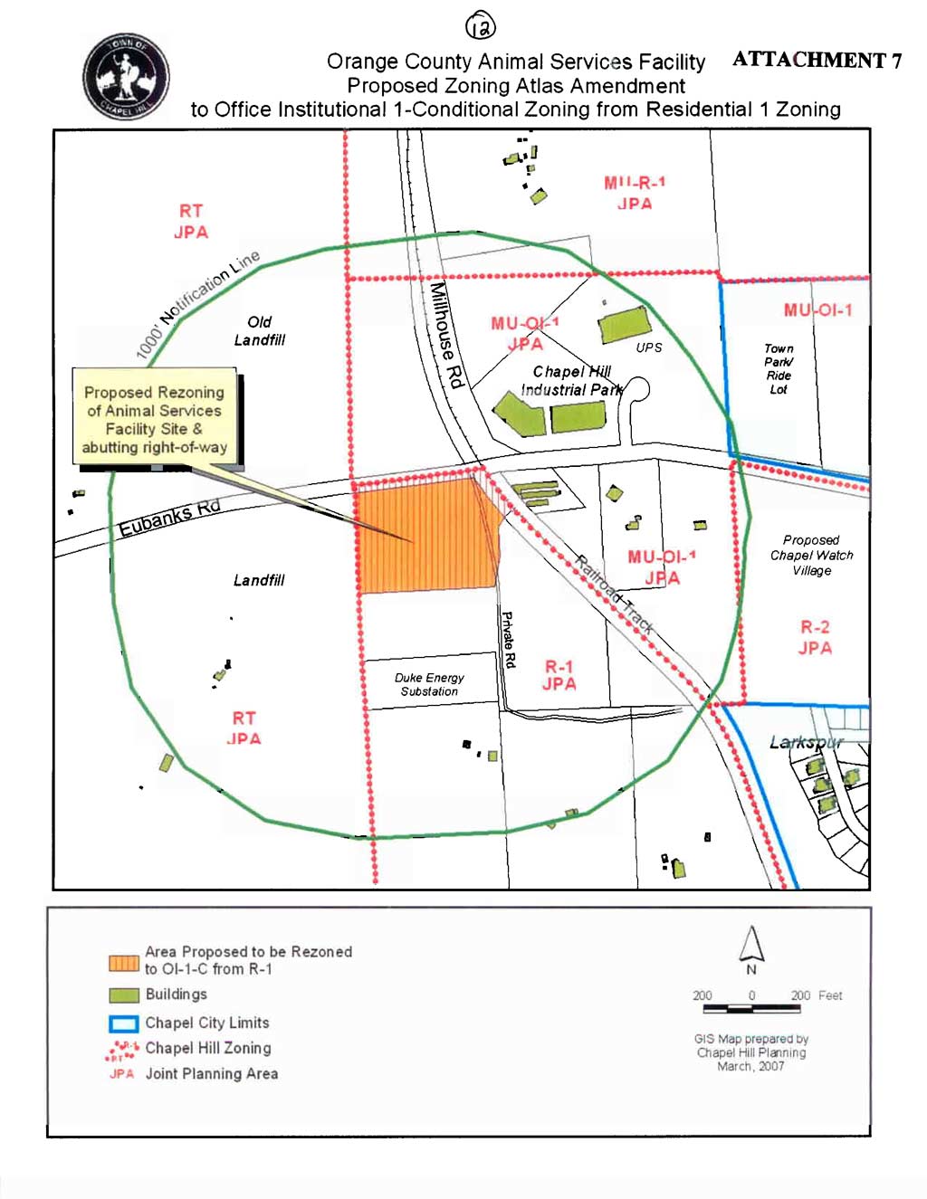
Tonight, the Council is considering a request for a Zoning Atlas Amendment to rezone a 5.96-acre site from Residential-1 (R-1) to the Office/Institutional-1-Conditional (OI-1-C) zoning district. The vacant site is located on the south side of Eubanks Road, between the Orange County Landfill and Millhouse Road. The property is identified as Orange County Property Identifier Number 9870-77-4584.
|
This package of material has been prepared for the Town Council’s consideration, and is organized as follows:
|
On March 21, 2007, the Town of Chapel Hill received an application for a Zoning Atlas Amendment to rezone 5.96 acres of land on the south side of Eubanks Road between the Orange County Landfill and Millhouse Road.
The applicant has requested that the site be rezoned from Residential-1 (R-1) to the Office/Institutional-1-Conditional (OI-1-C) zoning district. The existing Residential-1 zoning district allows a Public Service facility, such as an animal shelter, but has a maximum floor/area ratio of 0.076. The proposed zoning district, Office/Institutional-1-Conditional (OI-1-C), provides a maximum floor/area ratio of 0.264.
The “conditional” designation means that, if the rezoning is approved, no development may occur on the property unless the Town Council approves a Special Use Permit. The application received by the Town for the proposed Special Use Permit has been tentatively scheduled for a Public Hearing before the Town Council on June 18, 2007.
A Joint Planning Area Land Use Plan was initially adopted in 1986. Chapel Hill has since adopted a new Land Use Plan in May 2000, which Orange County adopted as an amendment to the 1986 Joint Planning Area Land Use Plan effective October 1, 2003.
The application site is located at the south side of Eubanks Road between the Orange County Landfill and Millhouse Road. The Joint Planning Area Land Use Plan, as amended, in this location is designated as “Low Residential,” one to four units per acre.
Zoning determines the type and intensity of uses and development that are allowed on a piece of land. A Zoning Atlas Amendment involves a change to the current zoning, and thus the permitted types and intensity of land uses. In Chapel Hill, a rezoning may be requested in two ways: general use and conditional use rezoning requests. A general use rezoning request is to change the zoning to a different zoning district in which any of several kinds of developments and uses are permissible. A conditional use rezoning request is to allow development and uses only with approval of a Special Use Permit. Consequently, if the Orange County Animal Services Facility conditional use rezoning request were to be approved by both the Town Council and the County Commissioners, the applicant would still need to receive approval for a Special Use Permit application prior to development actually occurring on the site.
The zoning designation of a property determines the range of land uses and development intensities permitted on the property. Article 4.4 of the Land Use Management Ordinance establishes the intent of Zoning Atlas Amendments by stating that, “In order to establish and maintain sound, stable, and desirable development within the planning jurisdiction of the Town it is intended that this chapter shall not be amended except:
a. to correct a manifest error in the chapter; or
b. because of changed or changing conditions in a particular area or in the jurisdiction generally; or
c. to achieve the purposes of the Comprehensive Plan.
Article 4.4 further indicates:
It is further intended that, if amended, this chapter be amended only as reasonably necessary to the promotion of the public health, safety, or general welfare, and in conformance with the Comprehensive Plan.
Opportunity for a protest petition to a proposed amendment to the Zoning Atlas is provided for under North Carolina statutes. If a protest petition is filed with the Town Clerk, the proposed rezoning shall not become effective except by favorable vote of not less than seven (7) members of the Town Council. Protest petition forms and additional information are available from the Planning Department. As of the writing of this memorandum, we are not aware of any valid protest petitions.
The site is presently zoned Residential-1 (R-1), which is a low density residential zoning district. The Residential-1 zoning district requires a 17,000 square-foot minimum lot size, establishes a floor/area ratio of 0.076, and establishes a density cap not to exceed three units per acre.
The applicant has submitted a Zoning Atlas Amendment requesting that the site be rezoned from Residential-1 (R-1) to the Office/Institutional-1-Conditional (OI-1-C) zoning district. The Office/Institutional-1-Conditional zoning district requires a 5,500 square-foot minimum lot size, establishes a floor/area ratio of 0.264, and establishes a density cap not to exceed 10 units per acre.
Analysis of this application is organized around the requirement of the Land Use Management Ordinance that Article 4.4 shall not be amended except a) to correct a manifest error in the chapter; or b) because of changed or changing conditions in a particular area or in the jurisdiction generally, or c) to achieve the purposes of the Comprehensive Plan.
A) A rezoning is necessary to correct a manifest error.
Staff Comment: We believe the information in the record to date can be summarized as follows:
Arguments in Support: We were unable to identify any arguments in support of a manifest error.
B) A rezoning is necessary because of changed or changing conditions in a particular area or in the jurisdiction generally.
Staff Comment: We believe the information in the record thus far can be summarized as follows:
Arguments in Support: No arguments have been made to date in support of changed or changing conditions in this particular area.
C) A rezoning is necessary to achieve the purposes of the Comprehensive Plan.
Staff Comment: We believe the information in the record thus far can be summarized as follows:
Arguments in Support: Arguments in support of this finding are offered in the applicant’s Statement of Justification (Attachment 4), which provides several references to the Comprehensive Plan. Portions of the applicant’s Statement of Justification are copied below:
“The proposed land use is consistent with a significant recommendation of the Town’s adopted Comprehensive Plan. The Plan identifies the general area around the subject property as the Northwest Focus Area. One recommendation of the Plan is to “Encourage regional cooperation, particularly with Orange County and Carrboro, to address the provision of services and infrastructure in the Northwest Area.” [Applicant’s Statement]
Recommendations are summarized below. Please see the attached summary of recommendations from the Planning Board.
Planning Board Recommendation: On April 3, 2007, the Planning Board voted 7-0 to recommend approval of the Zoning Atlas Amendment application. Please see the attached Summary of Planning Board Action.
Preliminary Recommendation: We believe that the rezoning could be justified based on finding C, as described above, as addressing the provision of services and infrastructure in the Northwest Area. Our preliminary recommendation is that the Council enact the attached ordinance, rezoning the property from Residential-1 (R-1) to the Office/Institutional-1-Conditional (OI-1-C) zoning district.
The attached Resolution would deny the rezoning request.