Concept Plan
For the
DRY CREEK GREENWAY TRAIL
Town of Chapel Hill, North Carolina
DRAFT
Prepared for:
Chapel Hill Town Council
Presented to the Council on November 19, 2007
Prepared by:
Lappas + Havener, PA
Landscape Architects – Land Planners
Durham, North Carolina
Technical Assistance provided by:
Ramey Kemp and Associates
Raleigh, North Carolina
Baker Engineering
Cary, North Carolina
Table of Contents
I. Project Overview 3
II. Project Goals 4
III. Design Issues 5
IV. Project Inventory and Analysis 7
V. Greenway Alternatives and Recommendations
Phase 1 9
Phase 2 13
VI. Future Connections 19
VII. Next Steps 20
List of Figures:
Figure 2: Dry Creek Trail Map 3
Figure 3: Town of Chapel Hill Greenways Master Plan 4
Figure 4: Entrance and Grass Area at Perry Creek Drive 11
Figure 5: Parking Lot and Erwin Road Entrance 12
Figure 6: Wetland Crossing Plan 16
Figure 7: Boardwalk Examples 18
Figure 8: Helical Piers Image 19
Exhibits: 22
A. Images of Existing Conditions
Appendix A. Technical Brief by Baker Engineering
Appendix B. Technical Brief by Ramey Kemp Associates
Appendix C. Preliminary Cost Projection
This Concept Plan is the first step toward the realization of the extension of the Dry Creek Greenway Trail from Perry Creek Drive to Providence Road. The Concept Plan analyzes issues relating to constructability, cost, environmental impact, land ownership, and experiential value of the trail and presents alternatives for routing the trail. The Concept Plan is intended to be a tool to help public officials make fully informed decisions for establishing project budgets and schedules, acquiring land and/or easements, and coordinating with other planned infrastructure improvements.
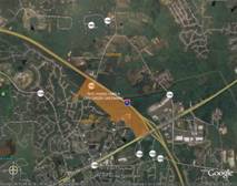
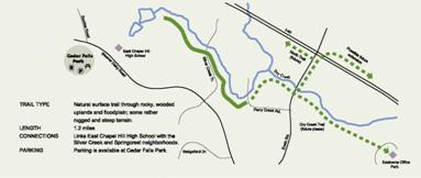
The Dry Creek Greenway is located in northeast Chapel Hill within the Dry Creek watershed. Dry Creek is a major tributary of New Hope Creek (Figure 1). The existing portion of the Dry Creek Trail is a natural surface trail that runs 1.2 miles along the southern branch of Dry Creek and links East Chapel Hill High School to the Silver Creek and Springcrest neighborhoods at Perry Creek Drive (Figure 2). From Perry Creek Drive, the trail continues as a natural surface trail, over an existing bridge and then connects to a series of loop trails within a 34-acre parcel bought by the Town of Chapel Hill in 2000. This portion of the trail is approximately 2,100 feet long.
Phase I of the greenway project would include surfacing a portion of the existing natural surface trail in asphalt and developing a new portion of the trail between the existing bridge and Erwin Road. Phase II would continue the trail from Erwin Road to Providence Road at the Eastowne Office Park. The current length of Dry Creek trail is 1.2 miles. The proposed length of Phase I would be approximately .5 miles and Phase II would be approximately .7 miles. When totally built out the project would extend the trail approximately 1.2 miles (Exhibit D). Though relatively short in length, Phase I of the Dry Creek Greenway would be a major step toward linking the Chapel Hill greenway system with Durham County, as well as connecting the Greenways system to major shopping centers along Highway 15-501. Phase II, from Erwin Road to Providence Road would provide low-impact access to one of Orange County’s most important ecological habitats.
Chapel Hill Greenway Trail Map
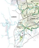
The alternatives discussed in this Concept Plan are consistent with the Chapel Hill Greenways Comprehensive Master Plan, adopted by the Town Council in January 2006 (Figure 3). The Concept Plan also provides specific recommendations for the construction of a pedestrian crossing at Erwin Road, a small, low-impact parking area on the west side of Erwin Road, two minor stream crossings, and a significantly long boardwalk/bridge across the wetlands located between Erwin Road and Providence Road.
Greenways Masterplan
The process used to develop the Dry Creek Greenway concept plan relied on a number of steps. Initially, goals were developed, evaluated and confirmed. The next step involved analysis of the site including the impact the greenway may have on its immediate neighbors; traffic demands and safety concerns for pedestrians, bicyclists, and motorists; location of existing utilities; jurisdictional requirements and environmental impacts relating to sensitive areas such as the floodplain, wetlands, habitat, mature vegetation and slopes; and views and features that would be enjoyable to the user.
After the site analysis was completed, a technical feasibility study determined more precise wetland boundaries in order to determine areas for resource protection and to measure environmental and construction costs.
The concept plan was developed using this data. The final stage in the process would be to seek approval of the Concept Plan by the Town Council. Upon Council approval, the Final Design phase of the Greenway can begin.
In order to best serve the community, the following goals were established to guide the implementation for the Dry Creek Greenway Concept Plan:
- Design a trail that would have as little disturbance to adjacent wetlands as possible.
The Dry Creek wetlands east of Erwin Road have been identified in The Inventory of the Natural Areas and Wildlife Habitats of Orange County, North Carolina as one of Orange County’s most significant natural areas. The trail will remain outside of jurisdictional wetlands except for one perpendicular crossing to access Providence Road.
- Design a trail that would have no rise in regulatory flood flows in Dry Creek. Ideally the design would avoid the necessity of submitting a Letter of Map Revision (LOMR) for any impacts to Dry Creek and its tributaries.
Flood modeling and a further study of stream channelization during the detailed design phase would determine more precisely the location of the boardwalk/bridge crossing.
- Provide a 10 foot wide trail with a maximum 5% slope to the greatest extent possible, between Perry Creek Drive and Providence Road.
This criterion, which is intended to meet the needs of disabled users, would be met throughout the length of the trail wherever possible.
- Utilize existing trails and disturbed areas where feasible to protect existing trees and minimize the impact to the environment.
A significant part of the proposed trail utilizes existing trails, sewer easements, and power easements. In forested areas, routes were located to avoid the majority of existing trees. Access to the wetland edge was determined to be the point where the least amount of grading would be necessary. Trails within the Chapel Hill greenway system are always, to some extent, field-located in order to avoid notable trees.
- Design an attractive, pedestrian-friendly and safe crossing of Erwin Road.
A preliminary study of road crossing options was analyzed with traffic engineers at NCDOT. This plan recommends a trail crossing that includes a pedestrian refuge, traffic control signs, adequate sight distances, and proper speed controls. The plan would be dependent upon final NCDOT approval.
- Minimize the impact of the Greenway to surrounding neighbors.
Fortunately, the majority of the proposed trail corridor has few close neighbors. The trailhead entrance at Perry Creek Drive has the most and closest neighbors. The trailhead at Providence Road would be near an apartment complex and adjacent to offices. In both locations appropriate buffer plantings and sensitive entrance plantings would minimize the impact of the trail.
- Avoid the need to relocate existing utilities.
The trail would avoid existing utilities such as sewer outlets, the OWASA substation, and transmission lines.
- Plan for a future link to the New Hope Creek Corridor and the Durham County Greenway System.
The extension of Dry Creek Trail to Erwin Road would be a major step toward future connections to the New Hope Creek corridor and the Durham County greenway system. A bridge widening at Erwin Road would be necessary for the safest crossing over I-40. In addition, some future bridge crossing of I-40 near Eastowne may be possible.
Trail Alignment
The recommended alignment utilizes existing trails, easements, and older logging roads to avoid impacts to existing trees and sensitive areas where possible. Substantial impact to the creek banks and wetland areas is anticipated. However, the use of helical piers and building a low boardwalk would also minimize the impact in wetland areas.
The recommended trail alignment leaves existing bridges, culverts, and water and sewer lines in place, with the exception of one narrow pedestrian bridge at the OWASA substation, which would be replaced to provide a safe crossing for non-motorized transportation use.
Erwin Road
Widening Erwin Road where the trail would cross is recommended in order to provide a pedestrian refuge island across this busy street. Potential addition of a bike lane along the Erwin Road right of way could be a first step towards connecting the Town of Chapel Hill greenway system to the Durham County Trailway System and the future New Hope Creek Trail.
The recommended realignment of Erwin Road would shift either one or both edges of the roadway five to ten feet within the existing right-of-way. This measure could potentially affect the appearance of the right-of-way in front of one property on Erwin Road. The improvement of drainage features and slope conditions along these frontages would be part of the realignment project and could allow for the addition of a bike lane or wide shoulder along Erwin Road. Early notification of all properties affected by this realignment is recommended.
Neighbor Issues
Aside from the two trailheads on Perry Creek Drive and Providence Road, the trail is sited away from existing residential areas. North of Perry Creek Drive, the alignment runs sixty to eighty feet behind existing houses. In addition to this horizontal separation, the trail would be approximately ten to twenty feet below these houses in elevation. The final design would provide screening of the trail from adjacent properties where necessary.
Natural History of Site
Between June 1987 and October 1988, Orange County contracted with the Triangle Land Conservancy to conduct an inventory of the “principal natural areas and wildlife habitats of Orange County.” The result of which was the document, The Inventory of the Natural Areas and Wildlife Habitats of Orange County, North Carolina. The study identified a total 64 significant natural sites in Orange County. In summary, the paper identified the Dry Creek area as one of only three significant Piedmont Swamp Forest sites in the County. The Piedmont Swamp Forest is unusual in Orange County and can only be found within the Triassic Basin area.
The site contains a relatively large swath of mature bottomland swamp forest. Significant tree species include: red maple (Acer rubrum), white ash (Fraxinus americanus), sweet gum (Liquidambar styraciflua), wouldow oak (Quercus phellos), Shumard’s oak (Quercus shunmardii), overcup oak (Q. lyrata), sycamore (Platanus occidentalis), and tulip poplar (Liriodendron tulipifera), with hop hornbeam (Ostrya virginiana) and ironwood (Carpinus caroliniana) occurring in the subcanopy. Water hemlock, lizard’s tail, false nettle, aneilema, lycopus, and jewelweed are the main herbaceous species.
The site is also host to a number of rare animal species. Marbled salamanders and other amphibians frequent the large pools for breeding. Thorey’s grayback dragonflys (Tachopteryx thoreyi), which is the most significant rare species identified on the site, breed in the shallow seeps located where the crystalline rock of the Piedmont meets the flat sediments of the Triassic Basin. Other common visitors to area include deer, raccoon, red fox, and groundhog.
Environmental Impact
Much of the proposed trail would lie within 100-year flood limits and the Town’s Resource Conservation District (RCD). However, the trail alignment should minimize the impact upon the storage capacity of the floodplain. Preliminary flood modeling confirming the general feasibility of the alternatives outlined in the Concept Plan is presented later in the Concept Plan. However, a more detailed analysis of the final alignments, cross-sections, and bridge structures would be required as part of the eventual design review and permitting process.
Although localized clearing of vegetation, including some larger trees, would be required, impacts to higher quality stands of mature trees can be largely avoided, particularly where existing utility corridors and existing trails can be utilized. The trail would travel through jurisdictional wetlands in at least one location. Any proposed impacts or disturbance to the stream channel of Dry Creek would fall within the review authority of the US Army Corps of Engineers. Construction would be required to utilize Best Management Practices for minimizing erosion and controlling sediment-laden runoff during construction in accordance with North Carolina Department of Environment and Natural Resources regulations.
Final design, including exact route selection, horizontal and vertical alignment, trail cross-sections, pavement markings, signage and signalization should adhere to the most current applicable NCDOT and AASHTO guidelines in place at the time of design. Trail access points and the Erwin Road street crossing should be located and designed to ensure adequate site distances and to minimize conflicts with vehicular traffic.
Connections to existing public sidewalks and rights-of-way should be made at Perry Creek Drive and at Providence Road. The at-grade street crossing occurring at Erwin Road should not have longitudinal slopes in excess of 1:20 (5%) and should in no case exceed the maximum gradient of 8%. Cross-slope or pavement crown should not exceed 1/4” per foot (2%). Bridge footings, abutments and pavement sections should be designed by a North Carolina licensed Geotechnical or Structural Engineer in consideration of localized soil conditions, potential for frequent inundation, and to withstand heavy vehicular traffic in instances where the trail could be used by OWASA or other utility providers.
Phase I: Perry Creek Drive to Erwin Road
Description
Phase I of the Dry Creek Greenway (Exhibit E) would begin on the north side of Perry Creek Drive. It would continue to the north along an existing gravel trail on an OWASA sewer easement. It would then cross a Duke Energy transmission line that runs adjacent to the creek. From there the trail would cross over a tributary of Dry Creek on an existing 5-ton rated corten steel bridge. Poorly drained soils and consistently wet conditions found on either side of the trail may require further grading near the entrance and bridge.
After crossing the bridge, the trail would turn to the northeast of the transmission easement and cross an ephemeral stream. Though dry most of the time, the steep slopes edging this ephemeral stream (see Appendix A) and the occasional rise in water level may require a culvert to maintain the trail. Minimal grading in this area is proposed to ensure a slope of 5% or less.
After crossing the ephemeral stream, the trail would continue to the north of the Dry Creek wetland area, avoiding close proximity to the Duke Energy power easement. This portion of the trail would be tree-covered and gently rolling as it runs along the side-slopes of a ridge. Though loblolly pines dominate this area, a mix of tree species, including red cedar, American beech, red oak, holly, tulip poplar, and sweet gum would provide shade, buffering from the easement, and interest along the trail. The proposed trail is aligned to avoid disturbance of mature trees. Where tree damage may occur, understory and canopy trees would be planted to encourage appropriate forest regeneration.
Phase I of the Dry Creek Greenway Trail would terminate at Erwin Road. A proposed parking lot with space for 8-10 vehicles would be located approximately two hundred feet north of the proposed crossing of Erwin Road. The parking lot is intended to serve visitors to the greenway trail, existing nature trails, and a future 5-acre park. The park is identified in the Town’s 2002 Parks and Recreation Master Plan.
Perry Creek Drive Entrance
The proposed trailhead at Perry Creek Drive would be located in the heart of the Springcrest neighborhood. It would include a crosswalk, which would connect the existing natural-surface Dry Creek Trail to the proposed paved trail. The entry along both sides of Perry Creek Drive would include Town of Chapel Hill greenway trail signage. Low maintenance, attractive, native plantings would line the entrance. Chapel Hill boulders and/or modest stone columns, consistent with those proposed along Erwin Road, would also tastefully demarcate the entrance to both sides of the trial.
The existing culvert under Perry Creek Drive creates a steep enough slope that some grading along the first 500 feet of
the trail would be required to maintain less than a 5% slope as the trail
slopes down to run along Dry Creek. Poorly drained soils and low-lying wet
areas to either side of the trail may require further grading and/or additional
drainage options.
Sewer outlets line the first 800 feet of the trail along Dry Creek. Steep slopes with larger boulder outcroppings are located on the opposite side of Dry Creek from the proposed trail and are of visual interest. Revegetation along portions of this stretch would help detract from the sewer outlets, provide additional drainage benefits, and buffer surrounding residential properties.
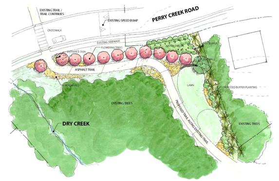
Grass Area at Perry Creek Road Trailhead
Adjacent neighbors have recommended that the existing, small grass area be graded at a 2% slope to provide a small play area for the neighborhood. As much as possible, the trail would hug the steeper slopes along the creek to provide as much open green space as possible. Buffer plantings of evergreens and native shrubs along the edge of the grass area would provide adequate screening along residential property to the north. The exact configuration of the grass area would be determined during the detailed design phase with the help of adjacent neighbors. The goal would be to create an area for neighborhood play while maintaining trail grades suitable for use by all visitors.
An 18”- 24” high stone retaining wall along the Perry Creek Drive side of the grass area would provide a place for visitors to sit and relax. Planting along the steep shoulder of the road which leads down to the grass area would provide seasonal interest, slope stabilization and protection from views of the road.
The following sketch shows one possible solution (Figure 4).
Proposed Route beyond the Perry Creek Road Trailhead
The trail would use the existing bridge over Dry Creek to reach Town property on the north side of the creek. This bridge was designed and located with the intention to continue the trail along the north side of the creek and avoid disturbing several thousand feet of wetlands surrounding Dry Creek. Furthermore, locating the trail on the north side of the creek would allow direct access from the Springcrest neighborhood to a proposed neighborhood park site, the proposed parking lot, and the preferred location of a pedestrian crossing at Erwin Road.
Parking Area and Trailheads at Erwin Road
Because the Erwin Road is an important gateway into Chapel Hill the parking lot, trailheads, phase II pedestrian crossing, and road widening should be designed with a level of detail that enhances ones sense of arrival into Town. The experience should add to the aesthetics of the trail. The design development phase of the project would include exploration of the use of public art, stone, and native plantings typical to Chapel Hill. The project should add to the beauty and aesthetics of the entranceway, while creating a place of interest that motorists would slow down to see as they pass through that location.
Three alternatives for the proposed parking lot were studied during the initial process for the Concept Plan:
- The west side of Erwin Road, 200 feet north of the proposed location of the Erwin Road crossing.
- The east side of Erwin Road near the Duke Energy access drive.
- Along the Duke Energy easement on the west side of Erwin Road
The first of these options is the preferred location for various reasons. This parking area could best serve visitors to the greenway, the existing Eagle Scout trails, and the future proposed 5-acre park.
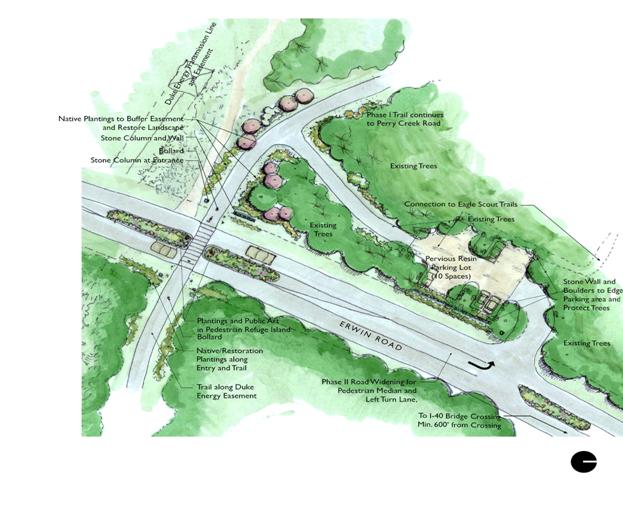
The proposed site for the parking lot is situated in close proximity to the existing trail entrance sign off of Erwin Road and is also within 100 feet from the proposed location of the paved trail. This distance provides adequate buffering from the trail but is close enough to the main trail to minimize the amount of grading and tree damage potentially required.
Phase II of Dry Creek Greenway would include widening a portion of Erwin Road to allow for a pedestrian refuge median and a left turn lane into the parking lot. Considerations of proper sight distances and deceleration requirements from both the bridge over I-40 and the pedestrian crossing determined that the best location for the parking is along the west side of Erwin Road (Appendix B).
The parking lot is set back an additional 10 feet from the 60 foot right-of-way of Erwin Road. This additional ten-foot set back would allow for adequate space for additional buffering from the road. The buffer could include items such as a low stone retaining wall and additional native shrub plantings. Modest stone columns at the parking lot and additional native plantings would
tastefully indicate the entrance to the parking lot. The design of the parking lot should provide pockets for parking spaces among existing trees. Boulders, stones and/or timber edging, plus native shrubs and groundcover planting could help protect existing trees from vehicular use by indicating parking space locations.
Because of the expressed concerns of citizens and the stated project goal of minimizing the trail’s impact to natural areas, various paving options for the parking lot were considered. Aggregate binders‑made of non-toxic, natural plant byproducts including plantago (Indian wheat) ‑ are porous, lighter in color and thus reflect light and reduce heat re-radiation. Aggregate binders act and look like compacted gravel, but allow better percolation. Unlike asphalt, aggregate binders do not contain petrochemicals, making them a preferred substitute around environmentally sensitive riparian corridors like Dry Creek and its surrounding wetlands. Using aggregate binders generally costs less than asphalt paving.
Resin Pavement, at approximately the same cost as asphalt paving, is also a binder emulsion that contains no petroleum ingredients but acts similarly to asphalt. The high stability and flexibility of this product is preferred over other aggregate binders because it offers the same environmentally sensitive ingredients and benefits, but is less likely to require as much maintenance and potential for loose, migrating gravel (Figure 5).
Phase II: Erwin Road to Providence Road
Description
Phase II of Dry Creek Greenway would begin on the east side of Erwin Road at or near the current location of an existing gravel road used by Duke Energy. This road is used to access the Eastgate tap station, which lies 900 feet east of Erwin Road. This Concept Plan proposes that the greenway utilize this existing road for up to 800 feet of its length. This portion of the plan is dependent upon Duke Energy allowing access on the road. A representative of Duke Energy has indicated that approval may be feasible if the Town is willing to make certain improvements to control access.
About 800 feet east of Erwin Road, the trail would leave the Duke Energy access road and pass to the north of the tap station. It would then traverse the Duke Energy utility easement at a 90-degree angle before entering the wooded area between the easement and Dry Creek. Here, the proposed trail would cross a small drainage swale and pass through a mixed hardwood and pine forest before arriving at the edge of the wetland area. From this point, a low boardwalk/bridge would convey the trail across the wetlands and braided channel of Dry Creek to the south edge of the wetlands.
From its landing point on the south side of the Dry Creek wetlands, the trail would run along an existing sanitary sewer easement toward an existing OWASA pump station. This segment could afford the opportunity to connect the trail to a nearby apartment complex.
Fifty feet from the pump station fence, the trail would cross a small tributary on a bridge. It would then continue parallel to the pump station fence and then up the hill toward Providence Road. The final stretch would partially use the existing gravel pump station access drive and an easement on the south side of the drive. The trailhead on Providence Road would mark the end of the Dry Creek Trail, Phase II.
The total length of Dry Creek Greenway Phase II would be about 3,420 lineal feet, not including a possible side trail to the apartment complex. Roughly half the length of the alignment would occur on land that is already cleared for access roads or easements. The remaining length would include 1,100 lineal feet of trail sited in and among upland forest, and a boardwalk/bridge structure of approximately 460 lineal feet. The intensity of construction required for the boardwalk wetland crossing would mean that the construction cost per lineal foot for Phase II would likely exceed that of Phase I by a significant margin (see Appendix C: Cost Estimate).
Erwin Road Crossing
In order to connect the Phase I greenway with Phase II, a crossing of Erwin Road would be necessary. The speed limit on this portion of Erwin Road is 35 MPH, which is reduced from a speed limit of 45 MPH just to the north of the project area. Cars are frequently observed at speeds of 55 mph and higher on this stretch of road, and the route is regularly used by motorists traveling between Chapel Hill and Durham. A safe crossing of this road is essential to the viability of the Greenway as a Town transportation and recreation facility.
The Concept Plan proposes a location for an at-grade crossing of Erwin Road that provides a 400 foot minimum sight distance from the crossing to approaching cars in either direction. It also recommends that the speed limit transition from 45 to 35 MPH be moved northward on Erwin Road to encourage slower speeds at the crossing location. In addition, the plan proposes the construction of a median island in Erwin Road to both alert drivers to the presence of a crosswalk and to serve as a “pedestrian refuge” for trail users (Figure 4). As shown, the pedestrian refuge can be combined with a left-turn lane for vehicles accessing the parking area from the south. The crosswalk location could be supplemented by flashing warning signs to the north and south and high-visibility pavement marking (see Appendix C).
Given an unlimited budget, it is conceivable that the greenway could be conveyed above the road on a bridge or beneath the road in a tunnel. Neither of these options was pursued for the following reasons. A bridge would require significant viaducts east and west of the road to gain the required clearance. The resulting structure would certainly be prohibitively expensive and would likely be an unacceptable intrusion into the very environment that the concept plan seeks to preserve. A tunnel, on the other hand, would require a detour to the north in order to keep the tunnel above the water table elevation, and significant grading and retaining walls on either side of the road to pass the trail beneath the fill slope of Erwin Road. A tunnel would also have a significant financial impact.
Duke Energy Access Road and Easement
The proposed location of the Erwin Road crossing has the added advantage of being in roughly the same location as an existing one-lane gravel road used by Duke Energy for access to and maintenance of their transmission facilities in the area. It lies within an easement for that purpose. This concept plan recommends that the Town of Chapel Hill and Duke Energy negotiate an agreement for the improvement and shared use of this road as a joint access road and greenway trail. At this writing, a Draft of the Concept Plan has been sent to Duke Energy’s Asset Protection Division for their information and feedback. The Plan proposes that the shared road would be a 12 foot wide asphalt road with HS-20 loading capacity and that a removable or collapsible bollard would be used at the Erwin Road entrance to allow only Duke Energy or Town vehicles to use the access road. If Duke Energy does not allow shared use of this road it would be necessary to align the greenway north of, and parallel to, the gravel road. This route would require substantial grading and clearing of existing trees.
The trail would leave the shared segment of road near the Eastgate Tap Station, cross the Duke Energy Easement at a right angle, and enter the wooded area to the south.
Upland Forest Area
This segment of the greenway between the tap station and the Dry Creek floodplain would be a winding trail through a forest of mature pines and large hardwoods. In order to site the trail without unnecessarily removing existing trees, a tree survey encompassing a wide swath of this area would be undertaken as part of the final design phase. Members of the public and the Greenways Commission voiced a strong preference for felling as few trees as possible in this area; therefore, the following measures should be employed in constructing the trail in this area.
- During the design phase the trail should be located, to a great extent, based on the results of the tree survey.
- During the construction phase the trail should be field located to some extent to save trees that do not appear on the tree survey.
- The trail should be installed with minimum excavation in the root zones of existing trees.
- In certain locations a minimum horizontal clearance of 2 feet between the edge of the trail and obstructions should be considered instead of the typical 3 foot clearance.
Wetland Crossing Alternatives
In order for the greenway to connect to Providence Road from the forested area north of Dry Creek, a crossing of Dry Creek and the wetlands around it is necessary. The only alternative to this crossing, and the northerly alignment of the trail in general, would be to align the trail along the OWASA sanitary sewer easement south of Dry Creek. This alternative was not pursued for several reasons:
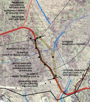
- Sight distance requirements would place the Erwin Road crossing well north of the OWASA easement (see above).
- This alignment would place the trail within 100 feet of five houses and within 150 feet of nine others in the Englewood neighborhood.
- The trail would have to be built in a low-lying, flood-prone area for about 2,400 feet. Most of this area is wetlands.
The concept plan proposes to span the Dry Creek wetlands with a boardwalk/bridge structure of approximately 460 feet in length. It would be located at the narrowest point possible between uplands to the north and the OWASA pump station access road off Providence Road to the south. A narrower crossing of the wetlands further west would be possible. This option, however, is not recommended because it would result in a greater overall impact to wetlands, and because the trail would be within 100 feet of at least two houses in the Englewood neighborhood (Figure 6).
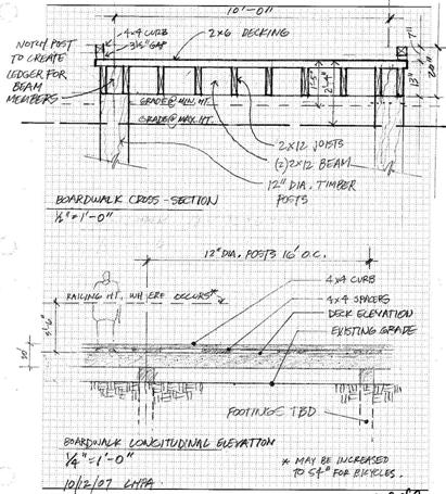
At the recommended crossing location, the concept plan team performed field mapping of the actual extent of wetlands, which shows them to be somewhat narrower than shown in National Wetlands Inventory (NWI) maps (see Appendix A). At this location, an elevated boardwalk is proposed, possibly incorporating a bridge span. Depending on its height, the boardwalk could be designed with or without railings.
According to the North Carolina Building Code (NCBC), a guardrail is required if a walking surface, i.e. the boardwalk deck, is thirty inches or higher above the ground surface below. The North Carolina Bicycle Facilities Planning and Design Guidelines, however, recommend a 54 inch-high safety rail for bicycle paths that are a foot or more higher than an adjacent surface, whether separated vertically or by a steep slope. The NCBC rule is legally binding on all projects in the state, whereas the NC Bicycle Guidelines are recommendations used by NCDOT’s Office of Bicycle and Pedestrian Transportation to evaluate NCDOT-funded projects.
A primary consideration in designing the boardwalk is that the proposed boardwalk crosses the floodway of Dry Creek and thus presents a potential obstacle to floods and debris flow. In order to obtain a permit for the construction of this structure, the Town would have to demonstrate (in the final design phase) that the introduction of the boardwalk would result in no increase, in the elevation of the 100-year flood event. This “no-rise” certification would be carried out by a qualified engineering firm and approved by FEMA and the U.S. Army Corps of Engineers. It appears that a railing on the boardwalk would not make it more difficult for the project to obtain a “no-rise” certification.
Another consideration in the design of the boardwalk is the possibility of debris, carried by the stream, accumulating against the boardwalk structure. According to guidelines published by the Federal Highway Administration, a relative lack of debris upstream, combined with low flow velocity and the presence of trees in the floodplain, argue against the possibility of significant debris accumulation (see References, No. 2). However, experience has shown that this can be a persistent and expensive maintenance problem. This issue should be addressed by a qualified hydrologist in the final design phase.
Options for the crossing currently being considered include:
- A low boardwalk without railings whose deck elevation is no more than 28 inches from the surrounding grade;
- A boardwalk that is low on both ends and raised in the middle, having railings in the middle third of its length;
- A boardwalk that is raised three or more feet above the surrounding grade, having railings along its whole length, with a bridge section that provides a clear span at the area of greatest flow.
- A boardwalk that is low on both ends, with a central bridge section that provides a clear span at the area of greatest flow.
Members of the Greenways Commission at the Public Hearing on September 26, 2007, expressed a strong preference for omitting railings from the boardwalk, and keeping the deck height as low as possible, in order to minimize the visual impact of the structure and allow users close observation of the wetlands environment.
Depending on what is learned from the flood model and further site investigation, it may be necessary to provide at least one area where the boardwalk would be split by a bridge structure. The main purpose would be to allow debris to flow under the structure during high water events. We have observed problems in other locations when structures have been built without any provision for allowing debris to move downstream. The final determination for the need for railings or a bridge component will be made in the detailed design phase of development.
(to be updated)
Boardwalk Structure
The Concept Plan team explored several construction alternatives for the boardwalk, primarily focused on differing methods of supporting and anchoring the structure. A design load of five tons was assumed for the boardwalk. For the boardwalk deck, joists, and beams, wood construction is the most economical choice. Substituting steel members for some of the larger wood members should be considered in the final design phase, however. A structural engineer should be consulted to determine whether using steel beams between posts, or example, would allow the structure to accommodate greater loads with a reduced profile.
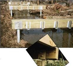
Two types of post with differing installation methods were considered for the boardwalk: steel helical piers (sometimes called screw shaft foundations) and timber piles. A third option, known by the trade name Pin Foundations, was considered but rejected because it is currently only used for light applications and would not accommodate 5-ton loading.
For the wetlands area at Dry Creek, helical piers are the recommended support method for the following reasons: First, like driven piles, helical piers require no soil excavation. Second, helical piers resist upward movement resulting from the possible buoyancy of the boardwalk structure in a flood event. Third, galvanized steel piers would be durable in the wetlands environment and, if required, are removable and reusable. Fourth, for a boardwalk lower than three feet, the required post size is only 1-1/2” square, which presents a very minor impediment to flood flows. Finally, helical piers can be installed with portable, hand held equipment (Figure 8).
The second-best option for post construction is to drive wood piles into the wetland soil until they reach a “point of refusal,” then install the beams, joists and
decking on the driven posts. York Bridge Concepts is one company that has developed a system for installing posts and constructing boardwalk ahead of the pile driving machinery, so that the installation machinery never needs to be in contact with the wetland surface.
The cost estimate (Appendix C) shows a slightly lower cost for the driven timber pile option compared with the helical piles. These costs should be reviewed in the final design phase to reflect current prices for steel and equipment. In our opinion, the reduced impact, narrower profile, and durability of the steel helical piers makes them a better choice for this location and
justifies a modest added expense.
Bridge at Tributary and Pump Station Area
South of Dry Creek, the greenway leaves the wetlands and runs along the OWASA sewer easement toward the pump station west of Providence Road, where it must cross a small incised stream. This stream appears as a “blueline” stream on USGS maps. This means that culvert across this stream would count as an “impact” for purposes of permitting by the US Army Corps of Engineers. In general, a project whose cumulative impacts to stream channels total 150 feet or more would trigger the need for an Individual permit from the USACE rather than a Nationwide permit. It is unlikely that cumulative impacts from the Dry Creek Greenway project would approach 150 feet even if a culvert were used here. However, given the stated goal of this project to reduce impacts where feasible, a 16-foot bridge with concrete abutments should be employed at this location rather than a culvert.
From this small bridge, the greenway would run past the OWASA pump station and then up to Providence Road on the existing access road alignment and an easement to the south. The trail installation would require some fill to the north of the pump station to overcome a steep side slope there. The trail gradient should be kept to 1:12 or less in this area, and would match the existing slope of the gravel access road to Providence Road.
The New Hope Corridor Open Space Master Plan (1991) and the Chapel Hill Greenways Master Plan (2007) both describe potential connections to future greenways along Dry Creek and New Hope Creek on the other side of Interstate 40. These recommendations include:
Durham/New Hope Connection at Erwin Road – This would involve extending a trail connection to the north along Erwin Road and across I-40 at the existing overpass. The trail would then run parallel to the NCDOT right-of-way of I-40 eastward to connect again with Dry Creek on the north side of I-40. From there the trail would continue into Durham County as part of the future New Hope Creek trail network. This option would require improvement of the existing bridge over I-40, possibly as part of future widening of Erwin Road. Such widening is not part of any Transportation Improvement Plan at this time. The town currently owns all of the land necessary except for one tract to the north of I-40.
Durham/New Hope Connection at New Bridge/Tunnel Location – A continuation of Dry Creek Greenway to some point south of I-40, where a bridge or tunnel would be needed to convey the trail over or under I-40, making a connection to Dry Creek on the north side of the freeway. It appears technically possible to build a tunnel beneath I-40 for this purpose at the existing Dry Creek culvert. However, the expense of such a project would be significant. A better option for a proposed crossing of I-40 might be a pedestrian bridge that takes advantage of high cut slopes further east, at the west end of the off-ramp to 15-501. Though also expensive, this option would provide a high-profile feature that could serve to “advertise” Chapel Hill’s greenways system and would be more likely to be used than a tunnel. To reach the southern landing of this bridge, the Dry Creek Greenway would follow the existing sewer easement behind the Eastowne office buildings as far as possible. The trail would then have to be “benched in” to the slope for about 200 feet before climbing the hill to the new bridge.
Connection to Future Development Site – Another possible option for a future connection is the probable future development site along 15-501 between Eastowne and I-40. The most economical way for the Dry Creek Greenway to reach this site would be for the trail to merge with Providence Road at the proposed Phase II trailhead. The road would be signed eastward toward Eastowne Drive. From that point a separate trail would run north of and parallel to Eastowne Drive. Such a connection would serve to link this future commercial area to the residential neighborhoods further west along Dry Creek.
Connection to the North Trail – The Town’s Greenways Master Plan shows a connection with the proposed North Trail. The North Trail would continue along the south side of I-40 from Erwin road to Millhouse Road. At this time natural surface trails reach a large tributary of Dry Creek west of Erwin Road, east of Silver Creek subdivision, and south of I-40. Once a bridge is installed across this stream the trail could be extended to the west.
Once the Council adopts a concept plan for this project we would then begin detailed design, which would include permitting. Upon completion of detail design we would anticipate construction of a trail from Perry Creek Drive to Erwin Road. This phase of construction would include a small parking lot. Conditioned upon review of updated costs and a review of available revenues we might be able to include design of the Erwin Crossing in Phase I.