AGENDA #9
MEMORANDUM
TO: Mayor and Town Council
FROM: Mayor’s Obey’s Creek Committee
Council Member Jim Ward, Chair
Council Member Cam Hill
Council Member Bill Strom
Council Member Edith Wiggins
SUBJECT: Report on Discussions about Proposed Development on US 15-501 South
DATE: September 7, 2004
This memorandum reports on the discussions of this Committee over the summer, and transmits comments and recommendations.
BACKGROUND
On May 10, 2004, Mr. Scott Kovens and Mr. Eric Chupp brought a petition to the Town Council, seeking discussion of a proposed Obey’s Creek development. The site is on the east side of Highway 15-501 South, across from Southern Village. A copy of the May 10 petition is attached (Attachment 1).
In response to the petition, Mayor Foy appointed a Mayor’s Committee to consider the petition, hear from the petitioners, and bring recommendations back to the Council.
The Committee met, heard a presentation from the petitioners describing plans for this property, and tonight offers suggestions to the Town Council regarding next steps.
DESCRIPTION OF PROPOSAL
The May 10 petition focuses on a site that is approximately 150 acres in size, with frontage along U.S. Highway 15-501 South. The site is south of the Town’s newest fire station, across the road from Southern Village. The petition includes maps that show the properties that would be included, but does not offer a specific development proposal.
At the request of the Committee, the petitioners brought forward preliminary details about what they envision for this property. At a July 16 meeting, the petitioners presented information about the site and the reasons they believe permitted density and permitted uses on the site should be increased. Handouts and background materials were presented to the Committee and are attached (Attachment 2).
A summary of the proposed development, as described on July 16, is as follows:
Drawings in Attachment 2 offer preliminary ideas from the petitioners about how the project might be designed.
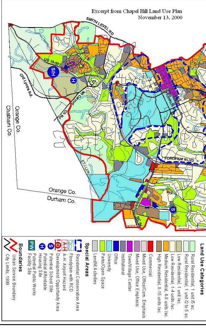
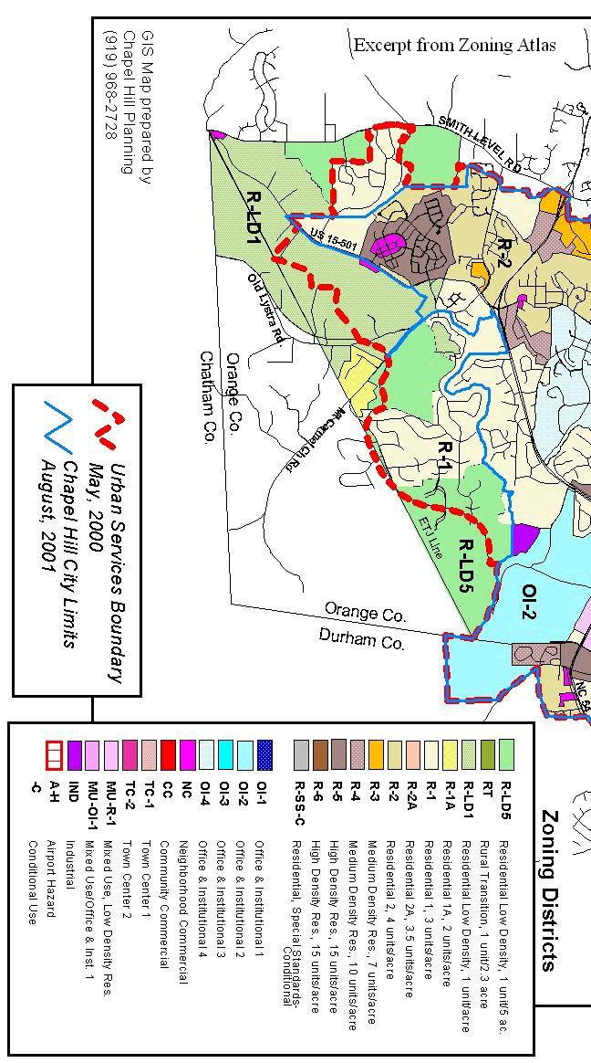
The site is currently designated as “Low Density Residential” on Chapel Hill’s Land Use Plan, along with designations indicating the location as a possible school site, and as a possibility for development of affordable housing. Current zoning of the site is R-LD1 (low density residential, with a 1-acre minimum lot size and a maximum floor area ratio of .047). The property is also in the Watershed Protection District. A copy of Chapel Hill’s Land Use Plan for this area is attached (Attachment 3), along with a copy of Chapel Hill’s zoning map for this area (Attachment 4).
COMMITTEE COMMENTS
What is permitted now?
The Committee asked Town staff for a summary of the existing regulatory environment for this site, with a description of what might be developed on the site under current policies and ordinances. The staff has offered the following scenarios based on existing regulations:
Single-family Subdivision: Maximum of 150 lots on a 150-acre site. 25% of the lots would be required to be restricted in size (37-38 lots, each with a maximum house size of 1,350 square feet of floor area for a period of 30 months). In lieu of 37 size-restricted lots, a developer would have the option of proposing (with the Council deciding whether or not to accept), 15% of the houses financed as affordable housing (22-23 houses) or a payment-in-lieu of providing 22-23 affordable houses. A cluster subdivision could be proposed, wherein individual lots might be smaller than one acre each, with the balance added to required open space.
Duplex Subdivision: Duplexes are not permitted in the R-LD1 zoning district unless they are part of a Planned Development.
Planned Development – Housing Special Use Permit: A Planned Development-Housing may be proposed in any residential zoning district, as long as the parcel size for the development is at least 5 acres in size. A Planned Development typically offers a variety of housing types including single-family and multi-family dwellings. The maximum number of units that could be developed on this property as a Planned Development would be 150 (maximum density = 1 per acre). The maximum floor area that could be developed would also be a constraint. If there were no RCD on this property, the maximum amount of floor area that could be built would be 307,000 square feet (150 acres multiplied by the floor area ratio of .047). Considering the likelihood that at least 30 acres of this site might be encumbered by RCD regulations, the maximum floor area that would be permitted drops to approximately 270,000 square feet. The Comprehensive Plan would suggest that 15% of the dwelling units that are developed be affordable to individuals/families making 80% or less of the area median income. If the average size of dwelling units were to be 2,000 square feet, then 135 dwellings could be constructed and it would be expected that 20 of those units meet the affordable definition.
Mixed-Use Planned Development: A Planned Development-Mixed Use may be proposed in any zoning district, as long as the parcel size for the development is at least 5 acres. The calculations for maximum allowable floor area are the same as described above. A mixed use development under existing regulations on this site would be limited to 270,000 square feet for all uses. For example, a proposal might be constructed with 120,000 square feet of retail and office space, and 100 units of housing averaging 1,500 square feet per dwelling. In this scenario, it would be expected that 15 of the dwelling units meet the affordable definition.
Comparison of Existing Regulations to Proposed Development
The petitioners suggest an intensity of use on this site that is approximately three to four times that which would be permitted by existing regulations. Accommodating a proposal of that nature would involve rezoning the property and/or amending regulations. Prior to consideration of action of that kind, a process to revise the existing policy framework for the Southern Area would be appropriate, including provisions for citizen involvement.
Comments on Existing Land Use Policies and Regulations
The existing policies that apply to this site and surrounding land were carefully put in place through a widely participatory process. Key policy documents are the Southern Small Area Plan, the existing Comprehensive Plan (with its component Land Use Plan), and the Land Use Management Ordinance. One reason to consider revisiting (or revising) those policies would be if a significant public objective would be advanced by making a change.
In the case of this property, one possible public objective that might be considered is the development of a significant quantity of affordable housing, beyond that which would typically be expected from all new residential development proposals.
Comments on Affordable Housing
Description of the proposal as envisioned by the petitioners has included reference to moderately-priced housing. If affordable housing were to be identified as the public policy reason to consider policy changes, it should be made clear that the Council’s definition of affordable housing is that which is affordable to individuals/families making 80% or less of the area’s median income. Recent estimates of a benchmark housing price that is affordable for purchase by such individuals/families range from $130,000 - $150,000.
It is the Council’s expectation that 15% of all new housing developments will be affordable according to this definition. One possible justification for higher intensity of use on this site could be a proposal that includes housing at currently permitted intensities, with 15% of that amount being available at affordable prices, and then allow additional intensity with all such additional units meeting the affordable definition.
Strip of Land, Bisecting the Site
There is a narrow strip of land that runs approximately in an east-west direction, bisecting this site. The land in question was deeded to the Town for Parks and Recreation purposes, as part of the recreation area requirement for an adjacent subdivision application (Zapata Lane subdivision, subsequently developed and built). A legal question emerges as to the ability of (and process for) the Town to consider making that land available for another development. If the Council wishes to pursue this possibility, the next step would likely be a request to the Town Attorney for procedural advice.
RECOMMENDATIONS FOR NEXT STEPS
The Committee’s conclusion regarding existing land use policies in the Southern Area is that the existing policies were put in place thoughtfully and with benefit of a highly participatory process, and that no policy change should be considered absent a new process that examines the full array of policies and circumstances for this area. An argument can be made that all policies can benefit from periodic review; however, there is not evidence that current conditions warrant such a policy review for the Southern Area at this time.
One reason to consider revisiting (or revising) a set of policies would be if a significant public objective would be advanced by making a change. In the case of this property, one possible public objective that might be considered is the development of a significant quantity of affordable housing beyond that which would typically be expected.
The petitioners have asked for feedback from the Council regarding how they might proceed with preparation of development plans for this site. We offer the following recommendations to the Council:
Regarding feedback to the petitioners, we suggest that the Council offer the following guidance:
Adoption of the attached resolution would offer this guidance to the petitioners.
ATTACHMENTS
A RESOLUTION OFFERING GUIDANCE TO PETITIONERS SEEKING TO PREPARE DEVELOPMENT PLANS FOR PROPERTY KNOWN AS OBEY’S CREEK (2004-09-07/R-15)
WHEREAS, on May 10, 2004, Mr. Scott Kovens and Mr. Eric Chupp brought a petition to the Town Council, seeking discussion of a proposed Obey’s Creek development. The site is on the east side of Highway 15-501 south, across from Southern Village; and
WHEREAS, a Mayor’s Committee was appointed to pursue discussions of this proposed development, and to bring suggestions back to the Town Council; and
WHEREAS, the Committee has completed and presented its work, and the Town Council has reviewed the circumstances of this site and this proposed development;
NOW, THEREFORE BE IT RESOLVED, by the Council of the Town of Chapel Hill that the Council offers the following guidance regarding potential development plans for this property:
This the 7th day of September, 2004.