AGENDA #12
MEMORANDUM
TO: Mayor and Town Council
From: W. Calvin Horton, Town Manager
Subject: Chancellor’s View Cluster Subdivision: Application for Preliminary Plat Approval (File No. 7.126.B.2)
Date: October 11, 2004
INTRODUCTION
Tonight the Council continues the Chancellor’s View Cluster Subdivision Public Hearing from September 20, 2004, regarding a Preliminary Plat application to authorize the subdivision of 32.41 acres into 25 lots. Adoption of Resolution A would approve a Preliminary Plat application with conditions. Adoption of Resolution B would deny the request.
|
This package of materials has been prepared for the Town Council’s consideration, and is organized as follows:
¨ Cover Memorandum: Provides background information on the development proposal and the Town’s review process, presents evidence in the record thus far in support of and in opposition to approval of the application, and offers recommendations for Council action.
¨ Attachments: Includes comments on issues raised during the September 20 Public Hearing, a letter from the applicant, a letter from Orange Community Housing and Land Trust, an area map, and a copy of the Public Hearing memorandum and its related attachments.
|
Background
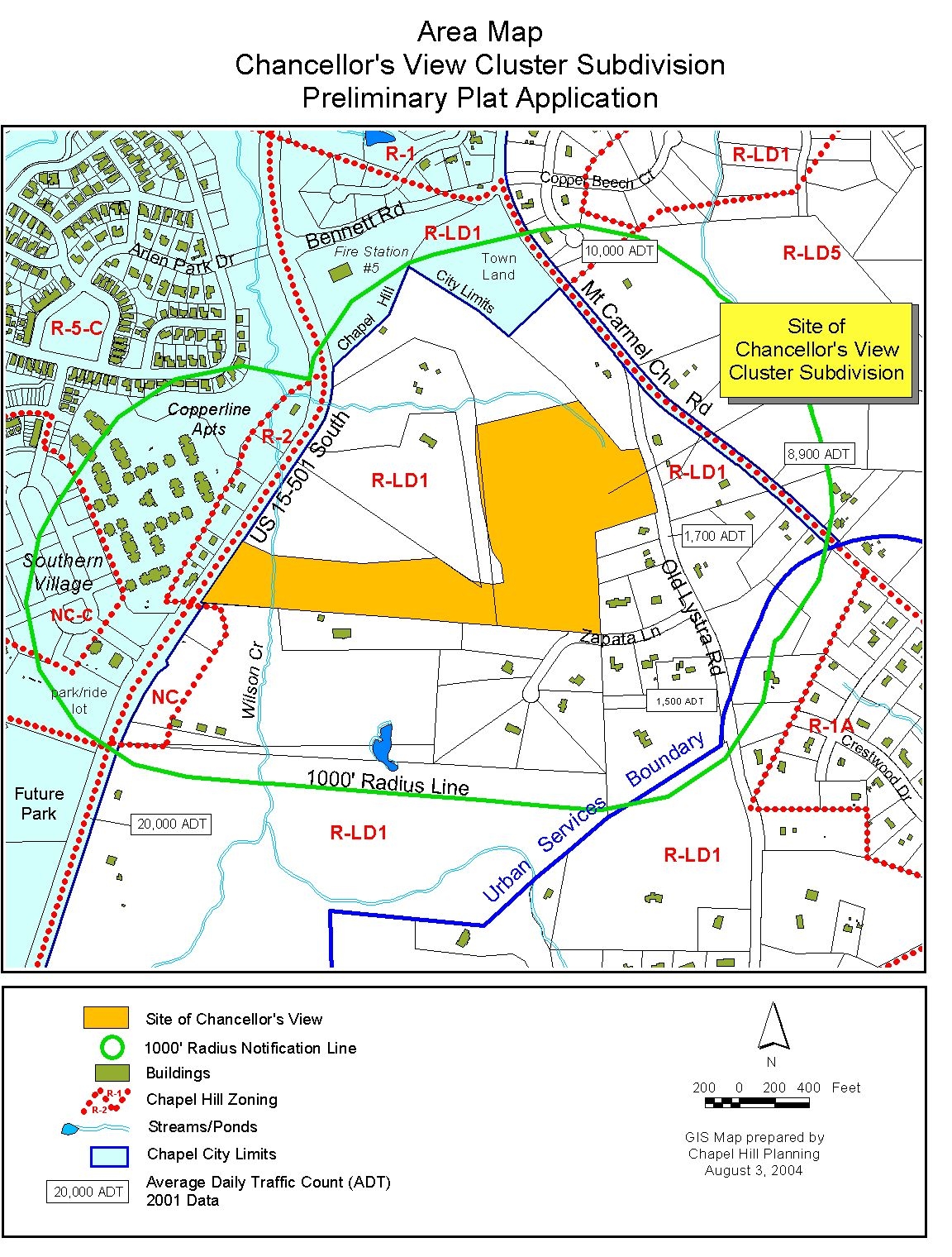
On September 20, 2004, a Public Hearing was held for consideration of a Preliminary Plat application to authorize the subdivision of 32.41 acres into 25 lots. The site is generally located northwest of the intersection of Old Lystra Road and Zapata Lane. A single point of access is proposed to the subdivision from Zapata Lane, terminating in a temporary T-turnaround and stub-out.
PROCESS
This is an application for Preliminary Plat approval. The Land Use Management Ordinance requires the Town Manager to conduct an evaluation of this Preliminary Plat application, to present a report to the Planning Board, and to present a report and recommendation to the Town Council. We have reviewed the application and evaluated it regarding its compliance with the standards and regulations of the Land Use Management Ordinance; we have presented a report to the Planning Board; and on September 20 we submitted our report and recommendation to the Council.
We note that review of subdivision proposals differs from review of Special Use Permits in that the question of compliance with regulations and standards is the basis for approval or denial, rather than the four findings of fact listed in Section 4.5.2 of the Land Use Management Ordinance. However, the Council’s review and action on a subdivision is quasi-judicial, with sworn testimony and evidence entered into the record.
The standard of review and approval of a Preliminary Plat application involves comparing the application with the regulations and standards in the Land Use Management Ordinance. The review typically focuses on vehicular and pedestrian access and circulation, traffic impact, public improvements, lot standards, and recreation area.
Information regarding this application was presented at the September 20 Public Hearing. The Land Use Management Ordinance directs that if, after consideration of the information, the Council decides that the application meets all the Land Use Management Ordinance requirements, the application must be approved. If the Council decides that the application does not meet all the Land Use Management Ordinance requirements, the application accordingly must be denied.
Furthermore, this Preliminary Plat application is for a cluster subdivision. The Council may approve a cluster subdivision in any residential district if it makes the five findings found in Section 3.8.8(b) of the Land Use Management Ordinance (see page 9 of attached Public Hearing memorandum). The Council may, if it chooses, make these five findings and approve this proposal as a cluster development.
evaluation of the application
Evaluation of this application centers on compliance with the subdivision regulations and standards in the Land Use Management Ordinance. We have attached a checklist of the Town’s subdivision regulations (see Attachment 2 of attached Public Hearing memorandum). The checklist indicates which of the Town’s regulations are satisfied by the applicant’s proposal, and recommended conditions.
The Council may find that the proposal meets the subdivision regulations and other pertinent Town regulations, or may find that the proposal does not meet the regulations.
KEY ISSUES
We believe that the key issues raised during the September 20 Public Hearing focused on affordable housing, traffic, light pollution, use of Lot 25, and greenway path signage. We offer additional information on these issues below.
Affordable Housing: Council members requested that the applicant consider alternatives to providing the proposed six lots with size-restricted dwellings, including providing three affordable homes interspersed throughout the main portion of the development.
Comment: The Land Use Management Ordinance regulations specify that at least 25% of the homes be restricted in size for a 30-month period. In lieu of providing size restrictions, the developer may offer and the Council may choose to accept 15% affordable units. If the Council authorizes the provision of 15% affordable units, at least 15% of the dwelling units of a major subdivision must be priced to be affordable to individuals and families who have incomes at or below 80% of the area median income for a family of four. For this proposal 15% of 25 lots is 3.75 units. The regulations indicate that resulting fractions are dropped. Therefore, if the developer offers and the Council approves the affordable housing option, three affordable units would be required.
The applicant has responded with a letter (see Attachment 3) addressing a number of the issues raised during the Public Hearing, including affordable housing. The applicant has offered, as an alternative to the proposed six size-restricted dwellings, to provide three affordable dwellings on Old Lystra Road in a similar configuration to that which was presented to the Council at the Concept Plan review in October, 2003. The applicant’s alternative proposes three affordable dwellings clustered on Old Lystra Road that would be separate from the main development off of Zapata Lane. The main development would have 21 market-rate dwellings. The 25th lot would be accessed from Highway 15-501.
We have attached a letter from Robert Dowling of Orange Community Housing and Land Trust addressing this issue (see Attachment 4). Mr. Dowling notes that Orange Community Housing and Land Trust would find the proposed three homes on Old Lystra Road agreeable if the applicant is willing to accept certain conditions, including: requiring Town Manager approval of siting, design, pricing, and construction quality of the affordable homes; timing of construction of the affordable homes relative to the market-rate homes; and that a marketing agreement be established between the developer and the Land Trust.
We believe that the two options presented by the applicant meet the requirements of Sections 3.8.5 and 3.8.6 of the Land Use Management Ordinance. We recommend approval of the six size-restricted dwellings, but believe that the applicant’s offer of three affordable dwellings on Old Lystra Road is also reasonable. If the Council chooses to approve the proposed subdivision with three affordable dwellings on Old Lystra Road, we recommend that Stipulation 4 of Resolution A be replaced with the following language, as recommended by Orange Community Housing and Land Trust:
Affordable Housing: That the provisions of Section 3.8.6.1 of the Land Use Management Ordinance, “Substitution of Affordable Housing for Floor Area Restrictions” shall apply to this development. That the final plans and plats shall indicate the specific lots dedicated to affordable housing, subject to Town Manager approval. That final siting, design, pricing, and construction quality of the affordable dwellings shall be subject to Town Manager approval prior to issuance of a Zoning Compliance Permit.
Traffic: A Council member expressed concern about traffic issues. Traffic issues discussed at the Public Hearing included turning movements onto Old Lystra Road from Zapata Lane, and speeding on Old Lystra Road.
Comment: As a matter of policy, the Town requires preparation of a Traffic Impact Analysis for all major subdivision applications. According to Town policy, the Town contracts with qualified engineers to perform the Traffic Impact Analysis, and the applicant pays for the cost of the study.
The Chancellor’s View subdivision application included a Town-prepared Traffic Impact Analysis, which estimated the traffic impacts of the proposed development on nearby roadways and intersections. The Traffic Impact Analysis states that the projected traffic impacts of the proposed development do not warrant roadway or signalization improvements at the studied intersections. The Traffic Impact Analysis recommended that a study be performed on Old Lystra Road in the vicinity of Zapata Lane to determine the optimum manner to either increase sight distance or reduce the speed of vehicular traffic. Any proposed measures to reduce speeds or increase sight distance would be subject to the approval of the Town and the North Carolina Department of Transportation. A stipulation to this effect is included in Resolution A.
The applicant’s letter responding to issues raised during the Public Hearing addresses the issue of traffic. The applicant notes that they agree with the conclusions of the Town-commissioned Traffic Impact Analysis, described above.
Light Pollution: In response to citizen comments related to concerns about light pollution with the proposed development, a Council member noted that the Planning Board is interested in studying the issue further for possible amendments to the existing lighting standards in the Land Use Management Ordinance.
Comment: The Planning Board has discussed forming a committee to study the existing lighting standards in the Land Use Management Ordinance and has requested additional information from the staff. For this application, the lighting standards in Section 5.11 of the Land Use Management Ordinance apply. Development of single-family homes on the lots created as part of this subdivision would be subject to the lighting standards in place at the time of development.
The applicant’s letter responding to issues raised during the Public Hearing addresses the issue of light pollution. The applicant notes their intention to comply with existing Town policies regarding lighting standards.
Use of Lot 25: In the applicant’s presentation, the applicant noted that Lot 25, designated on the site plan as “New Lot For Future Development”, is prohibited from development with this application.
Comment: We believe that adoption of Resolution A would not prohibit development of Lot 25. Lots 1-24 would be restricted to single-family dwelling unit use, but Lot 25 does not have that restriction. Lot 25 could be developed according to the uses permitted in the Residential-Low Density, 1 unit/acre (R-LD1) zoning. According to the R-LD1 zoning, a single-family dwelling or a single-family dwelling with an accessory apartment could be approved administratively on Lot 25. Other uses on Lot 25 that could be approved with either Site Plan Review or Special Use Permit approval include adult and child day care facilities, places of worship, non-profit recreational facilities, public use facilities, and schools.
Greenway Path Signage: A Council member requested that signs be placed at the entrances of the proposed greenway paths indicating that the paths are for public use.
Comment: We have included the following stipulation in Resolution A:
· Greenway Path Signage: That the applicant shall provide greenway path signage identifying the path at all points of entry. The signs shall state that the greenway paths are for public use, and shall comply with sign design standards contained in the Land Use Management Ordinance.
Council Options: There are two key points of Council discretion with this application, issues for which the Council may but is not required to accept a component of the proposal. The first of these is the fact that this is proposed as a cluster subdivision. The Land Use Management Ordinance states that the Council may approve a cluster development if it makes certain findings (Section 3.8.8). The findings are mostly dimensional in nature, and we believe that the Council can make the required findings (included in Resolution A). However, if the Council determines that a cluster design is not desirable or appropriate, the application cannot be approved.
The second point of Council discretion is the applicant’s proposal to substitute affordable units in lieu of size-restricted units. The regulations specify that at least 25% of the homes be restricted in size for a 30-month period. In this case, 25% represents six units. In lieu of providing size restrictions, the developer may offer and the Council may choose to accept 15% affordable units. If the Council authorizes the provision of 15% affordable units, at least 15% of the dwelling units of a major subdivision must be priced to be affordable to individuals and families who have incomes at or below 80% of the area median income for a family of four. For this proposal 15% is 3 units. The regulations indicate that resulting fractions are dropped. Therefore, if the Council approves the affordable housing option, three affordable housing units would be required. The Council is not required to approve the substitution.
RECOMMENDATIONS
Recommendations are summarized below. Please see the attached summaries of board actions and recommendations.
Planning Board Recommendation: The Planning Board reviewed this subdivision proposal on
August 3, 2004. The Board voted 7-0 to recommend that the Council approve the application with the adoption of Resolution A.
Transportation Board Recommendation: The Transportation Board reviewed this subdivision proposal on September 7, 2004. The Board voted 5-1 to recommend that the Council approve the application with the adoption of Resolution A.
Bicycle and Pedestrian Advisory Board Recommendation: The Bicycle and Pedestrian Advisory Board reviewed this subdivision proposal on August 24, 2004. The Board voted 5-0 to recommend that the Council approve the application with the adoption of Resolution A.
Parks and Recreation Commission Recommendation: The Parks and Recreation Commission reviewed this subdivision proposal on August 18, 2004. The Commission voted 10-0 to recommend that the Council approve the application with the adoption of Resolution A.
Greenways Commission Recommendation: The Greenways Commission reviewed this subdivision proposal on September 8, 2004. The Commission voted 6-0 to recommend that the Council approve the application with the adoption of Resolution A.
Manager’s Revised Recommendation: If the Council approves this subdivision as a cluster development, we recommend that the Council approve this Preliminary Plat application with the conditions listed in Resolution A. Furthermore, we recommend that the following new stipulation be included in Resolution A as part of the Manager’s Revised Recommendation:
· Greenway Path Signage: That the applicant shall provide greenway path signage identifying the path at all points of entry. The signs shall state that the greenway paths are for public use, and shall comply with sign design standards contained in the Land Use Management Ordinance.
We also recommend that the Stipulation #13 be revised to read:
13. Zapata Lane Maintenance: That Zapata Lane shall be accepted for maintenance by the North Carolina Department of Transportation prior to Final Plat approval by the Town Manager.
Resolution A has been revised to include a new stipulation for greenway path signage and a revised stipulation related to Zapata Lane maintenance.
Resolution B would deny the application.
RESOLUTION A
Manager’s Revised Recommendation,
Parks and Recreation Commission Recommendation,
Planning Board Recommendation,
Greenways Commission Recommendation,
Bicycle and Pedestrian Advisory Board Recommendation and
Transportation Board Recommendation
A RESOLUTION APPROVING AN APPLICATION FOR A PRELIMINARY PLAT FOR CHANCELLOR’S VIEW CLUSTER SUBDIVISION (File # 7.126.B.2) (2004-10-11/R-14a)
BE IT RESOLVED by the Council of the Town of Chapel Hill that it finds that the Chancellor’s View Cluster Subdivision, proposed by Capkov Ventures, LLC, on the property identified as Chapel Hill Township Tax Map 126, Block B, Lot 2, if developed according to the Preliminary Site Plan dated April 15, 2003, and revised May 19, 2004 and July 28, 2004, and the Existing Conditions map dated May 19, 2004, and revised July 28, 2004, and the conditions listed below, would comply with the provisions of the Town Design Manual and the Land Use Management Ordinance and specifically with the following cluster development requirements from Section 3.8.8(b) of the Land Use Management Ordinance:
1. The tract proposed for cluster development is at least two (2) acres in size;
2. Public, separate water supply and sewerage connections are available for every subdivided lot;
3. The total number of lots proposed for the tract, excluding parcels of reserved recreation area, is not greater than the number determined by multiplying the total gross land area by the maximum density established in Section 3.8 for that zoning district;
4. The recreation area within the tract shall conform to the recreation area standards of Section 5.5; and
5. The minimum amount of land reserved as recreation area shall be the sum of all reductions in minimum gross land area as a result of the cluster form of development, combined with the minimum recreation area reservation required in Section 5.5. Only the minimum recreation area reservation required in Section 5.5 may be dedicated outside the boundaries of the land being subdivided as specified in Section 5.5.2.
These findings are based on the following:
1. Expiration of Preliminary Plat: That this Preliminary Plat approval shall be valid for one year from the date of approval subject to reapproval by the Town Manager in accordance with the provisions of the Land Use Management Ordinance.
2. Number of Lots: That this approval shall authorize the creation of 25 lots on 32.41 acres.
3. Single-Family Restriction: That lots 1-24 are restricted to Single-Family Dwelling Unit use only. A note to this effect shall be placed on the final plat.
4. Floor Area Restrictions: That the provisions of Section 3.8.5 of the Land Use Management Ordinance, “Housing Floor Area Restrictions for Major Subdivision and Planned Development” shall apply to this development. That the final plans and plats shall indicate the specific lots and floor area restrictions for each lot on which size limitations are placed, subject to Town Manager approval.
Required Improvements
5. On-Site Road Improvements: That a 27-foot wide road, measured from back of curb to back of curb, with 30-inch wide curb and gutter within a 45-foot wide right-of-way shall be built to Town Standard.
6. Sidewalk Improvements: That a 5-foot wide sidewalk shall be built to Town standard on one side of the new road.
7. T-Turnaround: That the applicant shall provide a temporary T-Turnaround, large enough to accommodate service vehicles, on Lot 15. The associated easement shall be recorded on the final plat.
8. T-Turnaround Removal: That the T-Turnaround and associated easement shall be removed when the stubout is connected to future development to the west.
9. Off-Site Grading: That off-site temporary construction agreements, authorizing grading and landscaping, shall be provided for any off-site work, such as the area required for building the connection to Zapata Lane, and shall be approved by the Town Manager prior to recordation at the Orange County Register of Deeds Office. The agreements shall be recorded prior to initiation of work.
10. Stub-out: The new roadway shall be constructed to stub-out at the western property line between lots 14 and 15 and the open space area.
11. Stub-out Signage: Signage shall be located at the roadway stub-out that indicates the roadway will be extended for future development. The size, text, and color of the signs shall be subject to the Town Manager’s approval.
12. Sight Distance Improvements: That the recommendations related to sight distance improvements from the Traffic Impact Analysis, dated March 2002, shall be identified on the final plans and shall be subject to the Town Manager’s approval.
13. Zapata Lane Maintenance: That Zapata Lane shall be accepted for maintenance by the North Carolina Department of Transportation prior to Final Plat approval by the Town Manager.
14. Minimum Recreation Requirements: That a minimum of 15.54 acres of recreation area shall be provided for this development. The applicant or Homeowners’ Association shall remain responsible for the recreation area, unless and until the Town assumes responsibility.
15. Dedication of Recreation Areas: That the applicant provide for Town Manager review and approval, a deed conveying to the Homeowners’ Association the 15.54 acres identified as “Open Space.” These documents shall be reviewed and approved by the Town Manager prior to recordation at the Orange County Register of Deeds Office and cross-referenced on the final plat.
16. Town Recreation Easement: That the applicant shall grant a public access easement to the Town for the entire recreation area/open space. The easement shall provide public access to build and maintain trails and shall indicate that the following users be entitled to use the public recreation area: pedestrians, users of non-motorized vehicles, and motorized wheelchairs. The easement shall be recorded by deed at the Orange County Register of Deeds Office and shall be cross-referenced on the final plat.
17. Greenway Path Signage: That the applicant shall provide greenway path signage identifying the path at all points of entry. The signs shall state that the greenway paths are for public use, and shall comply with sign design standards contained in the Land Use Management Ordinance.
Stipulations Related to Landscaping
18. Landscape Buffers: That a 20-foot Type-C buffer shall be provided along the Old Lystra Road and Zapata Lane frontages, and that a 30-foot Type-D buffer shall be provided along the U.S. Highway 15-501 frontage.
19. Ownership of Landscape Buffers: The Old Lystra Road and Zapata Lane landscape buffers shall be on land that is deeded to the Homeowners’ Association.
20. Landscape Protection Plan: That a detailed Landscape Protection Plan, clearly indicating which rare and specimen trees will be removed and preserved, and indicating significant tree stands, and including Town standard landscaping protection notes, shall be approved by the Town Manager prior to issuance of a Zoning Compliance Permit.
21. Tree Protection Fencing: That the limits of land disturbance with tree protection fencing shall be shown on the Landscape Protection Plan, to be approved by the Town Manager prior to issuance of a Zoning Compliance Permit.
Stipulations Related to Homeowners’ Association
22. Homeowners’ Association: That a Homeowners’ Association be created that has the capacity to place a lien on the property of a member who does not pay the annual charges for maintenance of common areas, however designated. The Homeowners’ Association documents shall be approved by the Town Manager prior to recordation at the Orange County Register of Deeds Office and shall be cross-referenced on the final plat. The Homeowners’ Association documents shall comply with Section 4.6.7 of the Land Use Management Ordinance.
23. Boundaries: That the boundaries of the Resource Conservation District be indicated on the final plat and plan. A note shall be added to all final plats and plans, indicating, “Development shall be restricted within the Resource Conservation District in accordance with the Chapel Hill Land Use Management Ordinance.”
24. Variances: That all variances necessary for development within the Resource Conservation District be obtained before application for final plat or Final Plan approval for the subject phase(s) of development.
25. Buildable Lots: That no lot be created that would require a Resource Conservation District Variance in order to be built upon.
In addition, for each lot it must be demonstrated that there is sufficient buildable area outside the Resource Conservation District, slopes of 25% or greater, water quality vegetated buffers, other required landscape buffers, easements, and any applicable building setback limits.
26. Construction Standards: That for encroachment(s) into the Resource Conservation District the requirements and standards of Section 3.6.3(g) of the Land Use Management Ordinance and all other applicable Resource Conservation District regulations must be adhered to, unless the application is granted administrative exemptions from Section 3.6.3(h).
All required erosion control sediment basins and stormwater improvements, outside the public right-of-way, including associated clearing and grading be located entirely outside of the Resource Conservation District where practicable to minimize land disturbance. That all grading associated with the construction of a residence be located entirely outside of the Resource Conservation District.
27. Steep Slopes: That each submittal for Final Plan approval shall include a map showing lots and street segments on slopes of 10% or more, and indicating how the development and construction will comply with the steep slopes regulations in Section 5.3.2 of the Land Use Management Ordinance. The Town Manager shall decide if the proposed building and site engineering techniques are appropriate. These restrictions shall be referenced in the Homeowners’ Association documents.
Stipulations Related to Water, Sewer, and Other Utilities
28. Utility/Lighting Plan Approval: That the final Utility/Lighting Plan be approved by Duke Power Company, Orange Water and Sewer Authority, BellSouth, Public Service Company, Time Warner Cable, and the Town Manager prior to issuance of a Zoning Compliance Permit.
29. OWASA Easements: That easement documents as required by OWASA and the Town Manager be recorded concurrently with the final plat. That the final plat shall be approved by OWASA prior to Town Manager approval.
30. Placement of Utility Lines Underground: That all new utility lines shall be placed underground.
31. Fire Flow: That a fire flow report, shall be prepared and sealed by a registered professional engineer, and showing that flows meet the minimum requirements of the Town Design Manual, to be approved by the Town Manager prior to issuance of a Zoning Compliance Permit.
32. Fire Hydrant Spacing: That maximum spacing between fire hydrants shall not exceed 500 feet, subject to approval by the Town Manager.
33. Stormwater Management Plan: That prior to the issuance of a Zoning Compliance Permit the applicant shall submit a Stormwater Management Plan for review and approval by the Town Manager. The plan shall be based on the 1-year, 2-year, and 25-year frequency, 24-hour duration storms, where the post-development stormwater run-off rate shall not exceed the
pre-development rate. Engineered stormwater facilities shall also remove 85% total suspended solids and treat the first inch of precipitation utilizing NC Division of Water Quality design standards.
34. Best Management Practices: That the applicant shall employ Best Management Practices, such as drainage swales and level spreaders, to manage the rate and quality of runoff, based on best available information from the NC State University Cooperative Extension. Final design and locations shall be approved by the Town Manager prior to the issuance of a Zoning Compliance Permit. These stormwater management features shall not be permitted within approved landscaped bufferyard areas.
35. Storm Drainageway Easement: That all stormwater management improvements, outside public right-of-way, shall be located inside reserved storm drainageway easements, per Town guidelines, to be approved by the Town Manager prior to the issuance of a Zoning Compliance Permit.
36. Stormwater Operations and Maintenance Plan: That the applicant shall provide a Stormwater Operations and Maintenance Plan for all engineered stormwater facilities. The plan shall include the owner's financial responsibility and include the maintenance schedule of the facilities to ensure that it continues to function as originally intended and shall be approved by the Town Manager, prior to the issuance of a Zoning Compliance Permit. The Stormwater Operations and Maintenance Plan shall be referenced in the Homeowners’ Association documents.
37. State or Federal Approvals: That any required State or federal permits or any required encroachment agreements for development in areas such as wetlands must be approved by the appropriate agencies and copies of the approved permits be submitted to the Town Manager prior to the issuance of a Zoning Compliance Permit.
38. Street Names and Addresses: That the name of the development and its streets and house numbers be approved by the Town Manager prior to the issuance of a Zoning Compliance Permit.
39. Pavement Marking Plan: That the applicant submit a signage and pavement marking plan to be approved by the Town Manager prior to issuance of a Zoning Compliance Permit. The signs and pavement markings shall be installed by the applicant prior to issuance of the first Certificate of Occupancy for a structure on the new lots.
40. Construction Management Plan: That a Construction Management Plan, indicating how construction vehicle and pedestrian traffic will be managed, shall be approved by the Town Manager prior to the issuance of a Zoning Compliance Permit.
41. Solid Waste Management Plan: That a Solid Waste Management Plan, including provisions for recycling, and for managing and minimizing construction debris, shall be approved by the Town Manager prior to issuance of a Zoning Compliance Permit.
42. Open Burning: That the open burning of trees, limbs, stumps and construction debris association with this development is prohibited unless it is demonstrated to the Town Manager or his designee that no reasonable alternative means are available for removal of the materials from the subject property. The Fire Marshall may establish safety standards, which must be met in order to receive a permit under this Article.
43. Detailed Plans: That final detailed site plans, grading plans, utility/lighting plans, stormwater management plans (with hydrologic calculations), and landscape plans and landscape maintenance plans be approved by the Town Manager prior to issuance of a Zoning Compliance Permit, and that such plans conform to the plans approved by this application and demonstrate compliance with all applicable conditions and the design standards of the Land Use Management Ordinance and the Design Manual.
44. As-Built Plans: That as-built plans in DXF binary format using State plane coordinates, shall be provided for street improvements and all other existing or proposed impervious surfaces prior to issuance of the first Certificate of Occupancy.
45. Plant Rescue: That the applicant consider conducting plant rescue activities on the site prior to initiation of development activity.
46. Certificates of Occupancy: That no Certificates of Occupancy shall be issued until all required public improvements are completed; and that a note to this effect shall be placed on the final plat.
That if the Town Manager approves a phasing plan, no Certificates of Occupancy shall be issued for a phase until all required public improvements for that phase are complete; no Building Permits for any phase shall be issued until all public improvements required in previous phases are completed to a point adjacent to the new phase, and that a note to this effect shall be placed on the final plat.
47. Erosion Control: That a detailed soil erosion and sedimentation control plan, including provision for maintenance of facilities and modifications of the plan if necessary, be approved by the Orange County Erosion Control Officer and the Town Manager prior to issuance of a Zoning Compliance Permit.
That a performance guarantee be provided in accordance with Section 5-97.1 of the Town Code of Ordinances prior to issuance of any permit to begin land-disturbing activity.
48. Silt Control: That the applicant takes appropriate measures to prevent and remove the deposit of wet or dry silt on adjacent paved roadways.
49. Construction Sign: That the applicant shall post a construction sign that lists the property owner’s representative and telephone number, the contractor’s representative and telephone number, and a telephone number for regulatory information at the time of issuance of a Building Permit, prior to the commencement of any land disturbing activities. The construction sign may have a maximum of 4 square feet of display area and may not exceed 6 feet in height. The sign shall be non-illuminated, and shall consist of light letters on a dark background.
50. Schools Adequate Public Facilities Ordinance: That the applicant provide the necessary Certificate of Adequacy of Public Schools prior to recordation of the final plat.
51. Continued Validity: That continued validity and effectiveness of this approval is expressly conditioned on the continued compliance with the plans and conditions listed above.
52. Non-severability: That if any of the above conditions is held to be invalid, approval in its entirety shall be void.
BE IT FURTHER RESOLVED that the Council hereby approves the application for a Preliminary Plat for the Chancellor’s View Cluster Subdivision in accordance with the plans and conditions listed above.
This the 11th day of October, 2004.
RESOLUTION B
(Denying Application)
A RESOLUTION DENYING AN APPLICATION FOR A PRELIMINARY PLAT FOR CHANCELLOR’S VIEW CLUSTER SUBDIVISION (File No. 7.126.B.2) (2004-10-11/R-14b)
BE IT RESOLVED by the Council of the Town of Chapel Hill that it fails to finds that the Chancellor’s View Cluster Subdivision, proposed by Capkov Ventures, LLC on the property identified as Chapel Hill Township Tax Map 126, Block B, Lot 2, if developed according to the preliminary site plan dated April 15, 2003, and revised May 19, 2004 and July 28, 2004, and the Existing Conditions map dated May 19, 2004, and revised July 28, 2004, and the conditions listed below, would comply with the provisions of the Land Use Management Ordinance:
(INSERT REASONS FOR DENIAL)
BE IT FURTHER RESOLVED that the Council hereby denies the application for Preliminary Plat Approval for the Chancellor’s View Cluster Subdivision.
This the 11th day of October, 2004.