Part 7
DESIGN STANDARDS &
GUIDELINES
The Design
Standards and Guidelines section of the Master Plan provides a set of
parameters for implementing a consistent physical character for Chapel Hill
greenway system. The guidelines address the following design issues:
·
Corridor Width
Guidelines
·
Trail Classifications
·
Special Trail Needs
·
Trail Locations
·
Trail Amenities
·
Parking Areas
·
Accessibility
·
Naming Trails
·
Signage
Greenway design standards
and guidelines can help elected officials, advisory board members, and staff
make decisions involving the expenditure of public funds and the enhancement of
public safety. Decisions related to amounts of land or easements to be
purchased, the types of trails to construct, and the location of trails can be
facilitated by incorporating standards and guidelines in the greenways planning
and decision-making process.
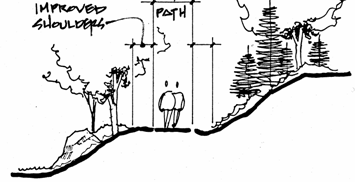
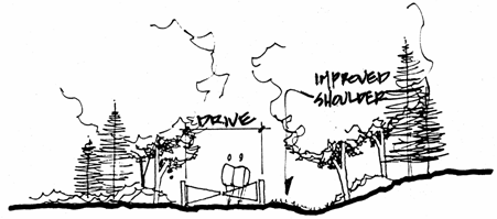
Corridor Width Guidelines
Greenway
corridors in Chapel Hill vary in width according to the topography of the area,
the amount of existing
development, the existence of significant biological areas, and patterns of
property ownership. The following guidelines are intended to balance the needs
to preserve greenway corridors and connectors, provide enough land for trails
when appropriate, and to provide privacy for existing residences.
The Town should
make reasonable attempts to protect the following greenway corridors by
restricting development, requiring greenway dedications, and purchasing land or
easements.
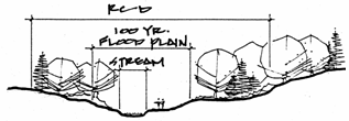
Stream
Corridors:
Stream corridors
may vary in width depending on the stream and the site specific characteristics
of the land itself. Corridor widths should generally be as wide as can be
acquired to help assure the privacy of adjacent property owners and the
environmental quality of the site. Several factors which often contribute to
increased corridor widths of stream-associated greenways include adjacent
sanitary sewer easements, 100-year floodplain land and areas within the Town’s
Resource Conservation District.
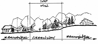
Connector
Trails:
Greenway
connectors not located along streams should be a minimum of 100 feet in width,
if possible. This width should allow for sufficient buffering between
neighborhoods, placement of trails, and adequate area for the free movement of
wildlife. Smaller corridor widths, however, may be necessary in order to
create trail connections between lots in subdivisions.
Greenways as
Parks:
Wider greenways
may be needed if the land is to be developed as a park. Parks require more
land than is typically acquired for a linear greenway. Parks and greenways can
share the same land, although the needs of the park may require additional
lands outside of the greenway corridor.

Developed
Areas:
Greenway
corridors or connectors should not be used for trails within areas that are
currently developed if placement of a greenway trail would severely impact the
privacy of existing residences. An exception would include areas where
approval of the development foresaw the construction of a trail. An example is
the Parkside II neighborhood where a connector trail corridor was preserved
relatively close to homes. In this case the planning and land acquisition was
complete prior to the construction of the first home.
Utility
Easements:
Pedestrian and non-motorized vehicle easements should be
coupled with utility easements when possible.
Trail Classifications
Trails proposed
within the Chapel Hill Greenway System can range from primitive woodland paths
designed for low intensity pedestrian travel to paved bike paths designed for
bicycle and wheelchair use.
The following
class system identifies different levels of trail development that were
assigned to greenway segments in Part 4, “Strategic Planning”. Essentially, it
is a 6-level hierarchy of trail development ranging from unimproved greenways,
to soft, natural surface trails, to paved trails of varying widths to
accommodate different trail uses and intensity of use.
Class 1 Unimproved greenways lacking trails.
No maintenance unless problems such as diseased or dying trees on Town-owned
greenways that affect neighboring properties.
Class 2 Primitive trails created by wildlife or
citizens, not maintained by the Town.
Class 3 Improved woodland trails generally with
soft surface and minimal improvements. Width is generally 1.5 - 4 feet.
Surface is typically natural, but may have gravel or boardwalk sections to
address erosion problems and wet areas. An important goal of the soft surface
trails is to safely accommodate mountain bicycles. Specific trail design
should address erosion problems likely to result from mountain bicycle use.
Maintenance typically includes removal of litter, removal of fallen tree limbs
and trees, repair of erosion damage, and bridging of wet areas.
Class 4 Unpaved access drive with gates or
bollards to prevent casual vehicle use. Suitable for pedestrians or mountain
bicycle use. This class is usually a road built for other purposes and used as
a trail.
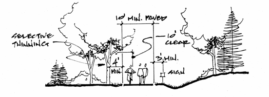
Class 5 Paved trail less than 10 feet wide.
This class of trail can be used to improve short sections of Class 3-4 trail
suffering from severe erosion problems. This class can also be used for
pedestrian or bicycle only trails which are signed against other uses
bicycle use. However, in situations of difficult terrain, this class of
trail can be employed for pedestrian and bicycle use, but only if signage is
displayed to warn users of possible conflicts.
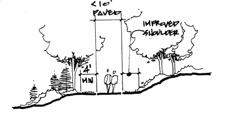
Class 6 Paved trail 10 feet in width or wider
for mixed bicycle and pedestrian traffic. Short sections may be less than 10
feet wide if difficult construction problems exist, however these should be
well signed with adequate sight-distance in order to assure the safety of trail
users.
The Town's goal
for all its paved trails is to be compliant with American Association of State
Highway and Transportation Officials (AASHTO) and Americans with Disabilities
Act (ADA) standards as much as is practicable. All Class 6 trails should be
designed and constructed to the standards for off-road bicycle trails as
published in the AASHTO “Guide for the Development of Bicycle Facilities” and
the North Carolina Department of Transportation’s, “Bicycle Facilities Planning
and Design Guidelines”. The editions of these publications which are current
at the time of trail construction should be used by the planning team. These
guidelines address design standards for trail alignment, design speeds, paving
widths and clearances, slope restrictions, bridge structures and safety
railings.
Class
6 trails should be designed to comply with ADA standards where possible. In
attempting to provide access to the greatest extent possible for the greatest
number of people, the Town’s Class 6 greenways will allow handicap, elderly and
very young users to more fully utilize the trails.
Special Trail Needs
There are some
special trail needs that may be considered by the Town for various reasons.
Some uses such as hiking and mountain bicycling may not be compatible on the
same trail. Specialty trail needs should be addressed if funds, land, and public
support are assured. Examples of special trail needs are listed below:
Mountain Bicycle Use
Class 3-4 trails
should be designed for the use of mountain bicycles whenever possible. The
extent of possible environmental damage by bicycle users should be considered
on every project. Mountain bicycle use may have to be curtailed on occasion to
allow natural regeneration of heavily eroded trails. Signs should be placed at
all Class 3 and 4 trailheads requesting mountain bicycle users to yield to
pedestrians and to refrain from using the trails in wet conditions.
Sidewalks and Public
Streets
In some cases, trail
connections will be on sidewalks and along public streets. In the event that
off-street bicycle paths merge onto streets, provide appropriate signage and
pavement markings to help safe merging. The provision of designated bicycle
lanes is desirable. Where a public street provides a link in a pedestrian path,
sidewalks should be provided where possible.
Interpretive Trails
Trails can meet
many different needs including education. Many trails can be converted to dual
recreational/educational use by placing interpretive signs and stations along
the pathway. Interpretive signage may identify or provide explanations of
special natural features, geographic, historic or other points of interest. Interpretive
trails should not be built in conjunction with trails that are anticipated to
have moderate to heavy bicycle traffic.
Fitness Trails
Fitness
trails have stations that are used for various exercises. Users often run from
station-to-station in order to work a variety of muscle groups. These features
can be incorporated into many existing trails. Fitness trails must be well
maintained with pathways that are free of obstacles. The various fitness stations
must be placed well off the actual trail. Fitness trails should not be built
in conjunction with trails that are anticipated to have moderate to heavy
bicycle traffic. It should be noted that public fitness trails, as a
recreational amenity, have decreased in popularity over the past several years.
Measured Trails
Many individuals
enjoy recreational walking and running. It is possible to measure sections of
trails and to mark them for persons wishing to monitor their mileage. This
type of activity is suitable on most trails, although, for fitness walking, the
path surface should be relatively stable and free of obstacles.
Trail Locations
The location of
trails within greenway corridors is of vital importance to greenways planners,
trail users, and the citizens who must live and work in the vicinity of these
trails. Greenway planners should consider the following trail location
guidelines:
1. Trails
should generally be located as far from residential structures as is reasonable
in order to preserve privacy of nearby residents and the experience of trail
users.
2. Trails of
Class 5 or higher should be located no closer than 25 feet from any perennial
stream bank unless absolutely necessary and no other practical location for the
trail exists. Trails should be located further than 25 feet from streams if
there is evidence that stream banks are eroding.
3. Stream
crossings should be avoided when possible.
4. Trails
should be located to ensure that minimum disruption of the trail would result
from the repair or replacement of utilities.
5. Street
crossings should be grade separated if possible. At grade, street crossings
should be planned so that trail and road users have the greatest sight distance
possible.
Trail Amenities
Certain amenities
may be planned to provide for the comfort and safety of trail users and area
residents. The Town may provide the following amenities within greenway
corridors:
Bollards
These devices
prevent automobiles from driving on greenway trails. Bollards are commonly
used on trails of Class 5 or higher. Bollards should be locked so that
emergency vehicles, police cars, and maintenance vehicles have access to the
trail.
The current
standard for a locking bollard is one with a recessed three-sided hydrant nut
that can be opened with a hydrant wrench.
Keys to
bollards should be provided to the Chapel Hill Parks & Recreation
Department, the Chapel Hill Police Department, Chapel Hill Fire Department,
South Orange Rescue Squad and the Orange Water and Sewer Authority, as
appropriate.
Observation Decks
Observation decks can be
built overlooking scenic areas. These structures should not be built within
floodplains, in places where they may compromise the privacy of nearby
residents, or in areas not readily accessible to maintenance vehicles.
Gazebos
These small
structures can be provided to allow trail users to enjoy passive recreation
activities such as resting, picnicking, or reading. These structures should
not be built within floodplains, in places where they may endanger the privacy
of nearby residents, or in areas not readily accessible to maintenance
vehicles.
Picnic Tables
Picnic tables
can be located along greenway trails, however past experience has found that
these amenities should not be placed at random. Picnic tables are more likely
to be used when placed in conjunction with some other attraction such as a play
area. These structures should not be built in places where they may compromise
the privacy of nearby residents, or in areas not readily accessible to
maintenance vehicles. Picnic tables should always be accompanied with litter
receptacles.
Benches
Many potential users of
greenway trails are elderly or physically challenged. Benches should be placed
where needed throughout the greenway trail corridor. Special care should be
taken to place benches at the top of steep sections of trail.
Parking Areas
Although one of
the primary purposes of greenways trails is that of providing non-motorized
transportation, many individuals will use the trails for purely recreational
purposes. In order to accommodate recreational users, provision of small
parking areas should be a goal and should be pursued when possible. In
many cases, existing parking lots within Town parks can be used.
Accessibility
The design of
greenway facilities and trail amenities should provide accessibility in
accordance with the American with Disabilities Act (ADA) standards to the
greatest degree practicable. Many trails, however, will not be wheelchair
accessible due to the constraints of existing terrain or due to the nature of
soft, natural surfacing. The design process for each trail should address the
priority of accessibility and provide the appropriate accommodations.
Naming Trails
Greenway corridors and
trails should be named after the most prominent natural, or in some cases,
man-made features in the immediate area of the trail. Trails located along
streams should be named after those watercourses. In the event that
non-contiguous sections of the same trail are developed it may be necessary to
adopt temporary names for trail sections. As the links are joined, the
temporary names can be abandoned. Procedures set by the Council should be
followed prior to naming or dedicating a trail or greenway corridor for an individual.
Signage
A coordinated and consistent signage program is important to the safety
and aesthetics of Chapel Hill’s greenway system. Signs serve to identify
trails, orient the greenway user and assist in way finding, but also have a
great collective impact on the overall visual quality of the greenway system.
Signage should
be used in a consistent, selective and strategic manner so as not to clutter
nor dominate the visual character of the greenway. Signs are generally to be
small and unobtrusive.
Entrance Signage
Main entrance signs marking
points of entry to each greenway should identify the name of the trail and
display the Chapel Hill greenways program logo. The main entrance sign should
be consistent in color throughout the Town system and should be constructed of
a wood relief panel, wall-mounted, or attached to wood or recycled material
posts.
Additional signs located at
the entrances should inform users of several key facts: where the trail ends,
the distance to the end of the trail, and what activities are not permitted
while using the trail. Signs marking Town greenways may not be placed on
University of North Carolina property.
Informational and Directional Signage
Signs
located along the course of the trail should inform users of the locations of
side trails, interesting features, proper direction of travel should confusing
options occur, and in the case of paved trails, directions for safe trail use.
Informational
and directional signs at pedestrian-only trails may be of wood panel
construction mounted on wood or recycled material posts. Signs should be
located at significant decision points and positioned to provide a clear
line-of-sight from the point of desired reading, free from obstructions.
Bicycle Routes
Paved
Class 6 trails designed for multiple uses will generally require more signage
than pedestrian-only trails. These signs are used in the same manner as
vehicular signage, but should be down-sized to remain in scale with the
greenway. These signs are typically constructed of metal panel and placed on
wood or recycled material posts.
Adequate
signs and markings are essential to alert pedestrians and bicyclists to
potential hazards and convey regulatory messages to vehicles at greenway
crossings. Signs and pavement markings at Class 6 multi-use trails should
follow the guidelines published in the “Manual of Uniform Traffic Control
Devices” (MUTCD).