AGENDA #5f
MEMORANDUM
TO: Mayor and Town Council
FROM: W. Calvin Horton, Town Manager
SUBJECT: Growth Management Report
DATE: June 24, 2002
This Growth Management Report is the first annual report intended to evaluate and interpret data on the demands and capacities of arterial roads, schools, and water and sewer facilities.
ABOUT THIS REPORT
The 2000 Comprehensive Plan discussed the importance of maintaining the viability of community systems and institutions that provide the services we need. The Plan called for ongoing attention to the capacities of key components of these systems, and for monitoring the impacts of growth on these capacities.
This is the first of what is to be an annual series of Growth Management Reports. The purpose of these reports is to assess capacities of key components of community infrastructure, review the effects of recent additional demands for services, and review the status of recent expansions of system capacities. The value of conducting this annual evaluation is to flag any existing or imminent situations where capacities are exceeded. This information can be useful in preparation of Capital Improvements Plans, adjustment of Land Use Plans, adjustment of development regulations, establishment of new or enhanced linkages with other institutions, and review of development applications. The intent is to provide an “early warning” of problems that may be emerging, so that corrective actions can be considered.
SUMMARY
The findings in this report related to arterial road, school, and water and sewer capacities are summarized as follows:
· Arterial Roads: Traffic volumes are exceeding the design capacity on several arterial roads in the southern and eastern regions of Chapel Hill, including segments of U.S. 15/501, Fordham Boulevard, South Columbia Street, and Estes Drive. Generally, traffic congestion in western and northern areas of Town is moderate. Franklin Street and other streets in the Town Center can handle more traffic while maintaining reasonable levels of service.
· Schools: The Chapel Hill-Carrboro City Schools are generally over capacity at the elementary level and under capacity at the middle school level at this time. The opening of a ninth elementary school in 2003 is expected to relieve capacity problems at the elementary level. The high school level is projected to be over capacity beginning with the upcoming 2002-03 school year, and no immediate plans are in place to mitigate the situation.
· Water and Sewer: The water and wastewater treatment plants operated by the Orange Water and Sewer Authority have sufficient capacity to handle existing demand as well as expected demand from approved projects. Both plants have reserve capacity to support future growth, and capital plans for expansion to both the water and wastewater treatment plants will add system capacity in the future as may be necessary to serve the community.
BACKGROUND
Comprehensive Plan
The Town’s Comprehensive Plan, adopted May 8, 2000, contains a variety of policies, strategies and actions to articulate the “vision and directions in which we want the community to move” and to “help us achieve the future we desire” (Comprehensive Plan, page i). The Comprehensive Plan contains a full description of the facilities needed by the Chapel Hill community. The Plan goes on to call for the development of a Growth Management Protocol and an annual Growth Management Report to help the community keep track of demands for services and capacities for services (Strategy 8B-1, page 71).
Growth Management Protocol
The Comprehensive Plan recommended the Council adopt a Growth Management Protocol. This Protocol would be “a framework developed to address the provision of public facilities and services to support development.” The Growth Management Protocol was adopted by the Council in October, 2000 (see Attachment 1).
TRANSPORTATION
Level of Service – Major Arterials
Road Capacities
Major arterials experiencing the worst congestion are those that serve as key commuter corridors on the periphery of the Town such as Fordham Boulevard, but also near the University, including Cameron Avenue, South Columbia Street and Raleigh Street, according to data in the Chapel Hill Mobility Report Card (2002). Downtown streets and intersections in the commercial core experienced among the highest Levels of Service in Town.
The Mobility Report Card analyzed locations based on Level of Service, which is based on a grade range of “A” to “F.” Those at Level of Service A to D, based on daily volume, are within the Town’s standards for acceptable road performance. Locations at Level of Service E or F – areas where traffic volumes utilize 90 percent or more of the road’s theoretical capacity – do not meet the Town’s standards.
The Mobility Report Card identified the locations in Table 1 as experiencing Level of Service F (volume/capacity of greater than 1) in at the AM peak hour, PM peak hour, and/or based on daily traffic volumes. Map 1 shows major arterials experiencing Levels of Service E or F based on daily traffic volumes.
Table 1. Arterials at Level of Service “F”
|
|
Volume to Capacity Ratio (and Level of Service) |
||
|
Location |
AM Peak |
PM Peak |
Daily |
|
Cameron Avenue between Columbia and Pittsboro Streets |
0.91 (E) |
1.42 (F) |
0.86 (D) |
|
Columbia Street between South Road and Cameron Avenue |
1.39 (F) |
2.14 (F) |
0.40 (A) |
|
South Columbia Street south of Mason Farm Road |
1.70 (F) |
1.77 (F) |
1.20 (F) |
|
Country Club Road north of South Road |
0.91 (E) |
1.42 (F) |
0.98 (E) |
|
Estes Drive east of Airport Road |
1.17 (F) |
1.25 (F) |
1.02 (F) |
|
Estes Drive west of Franklin Street |
0.95 (E) |
1.10 (F) |
0.93 (E) |
|
Fordham Boulevard east of U.S. 15/501 South exit |
1.46 (F) |
1.32 (F) |
1.15 (F) |
|
Fordham Boulevard south of Estes Drive |
0.94 (E) |
1.06 (F) |
1.08 (F) |
|
Fordham Boulevard south of South Road |
1.36 (F) |
1.19 (F) |
1.36 (F) |
|
Homestead Road east of Railroad |
1.03 (F) |
0.83 (D) |
0.64 (B) |
|
Manning Drive east of Ridge Road |
1.05 (F) |
1.00 (E) |
0.66 (B) |
|
N.C. 54 Bypass at Kingwood Apartments |
1.32 (F) |
1.16 (F) |
0.93 (E) |
|
N.C. 54 Bypass at Glen Lennox |
1.03 (F) |
0.87 (D) |
0.87 (D) |
|
Pittsboro Street south of McCauley Street |
1.05 (F) |
1.09 (F) |
0.53 (A) |
|
Raleigh Street south of Franklin Street |
1.06 (F) |
1.19 (F) |
1.14 (F) |
|
Raleigh Street west of 15/501 interchange |
1.10 (F) |
1.07 (F) |
0.40 (A) |
|
Ridge Road/Manning Drive |
1.04 (F) |
0.82 (D) |
0.61 (B) |
|
South Road east of Columbia Street |
0.62 (B) |
1.01 (F) |
0.76 (C) |
|
U.S. 15/501 between both Eastowne Drives |
2.37 (F) |
2.52 (F) |
1.18 (F) |
|
U.S. 15/501 South north of Culbreth Road |
2.41 (F) |
2.84 (F) |
1.77 (F) |
|
U.S. 15/501 South south of Culbreth Road |
1.53 (F) |
1.54 (F) |
1.18 (F) |
|
U.S. 15/501 west of Erwin Road |
0.97 (E) |
0.98 (E) |
1.09 (F) |
|
U.S. 15/501 west of Sage Road |
0.94 (E) |
1.07 (F) |
1.14 (F) |
Intersection Capacities
Map 2 shows the Level of Service of intersections analyzed in the Mobility Report Card. For intersections, a Level of Service of E indicates a delay of 55 to 80 seconds; Level of Service F indicates a delay of more than 80 seconds. The longest delays are on U.S. 15/501 and Fordham Boulevard.
Capital Plans
Transportation Improvement Plan Projects
Table 2 summarizes transportation projects in the State’s Draft 2004-10 Transportation Improvement Program (June 2002).
Projects in areas at Level of Service “F” include:
· U.S. 15-501 projects (U-2807 and U-4008), which would improve sections of road currently at Level of Service “F” during the peak AM and PM hours. The “Superstreet” project at U.S. 15/501 and Erwin Road is scheduled for construction in Federal Fiscal Year 2004. The improvements to U.S. 15-501 from Franklin Street to the Durham 15-501 Bypass are not scheduled to begin within the 2004-10 timeframe, with the cost estimated at $117 million.
· The Estes Drive improvement project (U-2909), which would widen Estes Drive from Greensboro Street to NC 86 currently at Level of Service “E” in the PM peak hour. This project is programmed in the Draft Transportation Improvement Program for planning and environmental study only.
· The South Columbia Street improvement project, which would provide limited improvement of South Columbia Street from Purefoy Road to Manning Drive is programmed to begin in Federal Fiscal Year 2005.
Sections of Fordham Boulevard near Manning Drive that are at Level of Service E and F in the AM and PM peak hours are not programmed for any transportation improvements.
Table 2. 2004-10 Draft Transportation Improvement Program (June 2002)
|
*FFY= Federal Fiscal Year
Source: 2004-10 Transportation Improvement Program (Draft), June 2002 (N.C. Department of Transportation)
Sidewalks and Bikeways
Plans for these Transportation Improvement Program widening projects include sidewalks and bicycle facilities (bike lanes or wide outside lanes): South Columbia Street, Homestead Road, Weaver Dairy Road, and Estes Drive. A bicycle facilities feasibility study is scheduled for Seawell School Road. The Transportation Improvement Program includes the construction of bike lanes on Old Durham-Chapel Hill Road, starting in Federal Fiscal Year 2003.
The Manager’s Recommended 2002-17 Capital Improvements Program includes $75,000 to $225,000 a year from 2003-04 to 20016-17 for sidewalk and bicycle facilities, with funding recommended in 2002-03 if utility franchise and beer and wine taxes are available.
New Sidewalk and Bicycle Facilities
Map 3 shows existing sidewalks in Town. The map shows those segments that have been built since 1996 have mostly been within subdivisions such as Southern Village and Meadowmont, though progress has been made expanding sidewalks along Airport Road. Arterials such as Weaver Dairy Road and Estes Drive and sections of Airport Road, however, lack sidewalks altogether or have gaps between existing segments.
Recently completed shared bicycle and pedestrian facilities include the Lower Booker Creek Greenway and the off-street paths built in Meadowmont by the Meadowmont developer.
Conclusion
Roads. Traffic volumes are exceeding the design capacity of several major arterials in the eastern and southern parts of Town, including U.S. 15/501, Fordham Boulevard, South Columbia Street, and Estes Drive. The next scheduled major transportation improvement is the “superstreet” project at U.S. 15/501 and Erwin Road, with construction to begin in 2004, followed by the Columbia Street and Homestead Road widening projects in 2005 and the Weaver Dairy widening in 2006.
Traffic congestion in northern Chapel Hill – north of Estes Drive and U.S. 15/501 – is moderate to light. Traffic volumes on the Town’s major north-south route, Airport Road, are the heaviest between Estes Drive and Weaver Dairy Road, a stretch where the Level of Service is at D based on daily volume; however, conditions on Airport Road during the AM and PM peak hours are actually better than that, measured in the Mobility Report Card at Levels of Service B and C.
Franklin Street and other streets in the Town Center can handle more traffic based on roadway capacity, with several stretches at Level of Service A.
Sidewalks and Bicycle Facilities. Sidewalks are mostly intact throughout the downtown area and on and near campus, with some exceptions such as areas on East and West Rosemary Street. Significant gaps exist in all other areas of Town, including along several major arterials such as South Columbia Street in between the University and Southern Village, and sections of Airport Road, Estes Drive, and Weaver Dairy Road.
SCHOOL CAPACITY
Current and Projected Membership
The Town of Chapel Hill is part of the Chapel Hill-Carrboro City School District, which includes eight elementary schools, four middle schools, two high schools, and a school based at the UNC Hospital for school-aged patients (see Map 4). A ninth elementary school is under construction in the Meadowmont development, expected to be open for the 2003-04 school year.
Table 3 compares enrollment at each of the system’s schools to each school’s capacity for the 2001-02 school year.
Of the eight elementary schools, five were over-capacity, with Seawell Elementary the most over-capacity at 136%. Currently, Glenwood Elementary has the most available space, at 83 percent of capacity in 2001-02. The school district projects that with the opening of the ninth elementary school, elementary schools system-wide will be at 96 percent capacity in 2003-04 (see Figure 1).
Table 3. Membership and Capacity, 2001-021
|
School |
Enrollment |
Capacity |
Available Space |
Enrollment as % of Capacity |
|
Carrboro Elementary |
492 |
563 |
71 |
87% |
|
Ephesus Elementary |
550 |
472 |
-78 |
117% |
|
Estes Hills Elementary |
555 |
549 |
-6 |
101% |
|
Glenwood Elementary |
371 |
445 |
74 |
83% |
|
FP Graham Elementary |
587 |
570 |
-17 |
103% |
|
McDougle Elementary |
669 |
596 |
-73 |
112% |
|
Scroggs Elementary |
572 |
609 |
37 |
94% |
|
Seawell Elementary |
676 |
498 |
-178 |
136% |
|
Sub-total: Elem. Schools |
4,472 |
4,302 |
-170 |
104% |
|
Culbreth Middle School |
644 |
670 |
26 |
96% |
|
McDougle Middle School |
634 |
732 |
98 |
87% |
|
Phillips Middle School |
749 |
706 |
-43 |
106% |
|
Smith Middle School |
521 |
732 |
211 |
71% |
|
Sub-total: Middle Schools |
2,548 |
2,840 |
292 |
90% |
|
Chapel Hill High School |
1,560 |
1,520 |
-40 |
103% |
|
East Chapel Hill High School |
1,395 |
1,515 |
120 |
92% |
|
Sub-total: High Schools |
2,955 |
3,035 |
80 |
97% |
|
Total2 |
9,975 |
10,177 |
202 |
98% |
|
Source: Chapel Hill-Carrboro City Schools |
||||
|
1Enrollment, capacity as of Oct. 2001. (Mobile units not included). 2Excluding Hospital School enrollment. |
||||
In 2001-02, middle schools system-wide were at 90 percent of capacity, due in large part to the opening of Smith Middle School at the beginning of the 2001-02 school year. Only one middle school, Phillips Middle School, is over capacity (106 percent). The school district projects the middle schools will be over capacity beginning in the 2006-07 school year (see Figure 2).
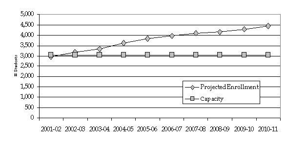
Together, the two system high schools, Chapel Hill High School and East Chapel Hill High School, were at 97 percent capacity. Chapel Hill High School is slightly over capacity (103 percent) and East Chapel Hill High School is under capacity (92 percent). The school district projects the high schools, as a whole, will be over capacity beginning with the 2002-03 school year, reaching 146 percent capacity by the 2010-11 school year (see Figure 3).
Capacity refers to the number of permanent seats available in schools, and does not represent the number of seats provided in mobile or relocatable units. Membership refers to the actual occupants of desks.
Adequate Public Facilities Ordinance for Schools
A draft Adequate Public Facilities Ordinance for Schools is currently under consideration by Orange County, Carrboro, Chapel Hill, and the two school districts in Orange County. The draft ordinance would be a development regulation tool which proposes to synchronize new residential development with the availability of school facilities, so that growth matches the availability of school facilities as noted in the school district’s Capital Improvements Plans. To date, the Chapel Hill Town Council, Carrboro Board of Aldermen, and the Chapel Hill Carrboro City School Board have adopted the Memorandum of Understanding. The ordinance is expected to be considered this fall.
Capital Plans
The ninth elementary school, located in the Meadowmont development, is currently under construction and is expected to be open for the beginning of the 2003-04 school year.
Conclusion
Overall, the Chapel Hill Carrboro City Schools are currently over capacity at the elementary level and under capacity at the middle school level. The opening of the ninth elementary school in 2003 will relieve capacity problems at the elementary level. The high school level is projected to be over capacity beginning with the upcoming 2002-03 school year.
Figure 1. Elementary, Projected Enrollment vs. Capacity, 2001-02 to 2010-11
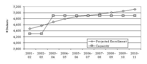
Figure 2. Middle Schools, Projected Enrollment vs. Capacity, 2001-02 to 2010-11
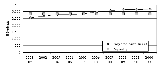
Figure 3. High Schools, Projected Enrollment vs. Capacity, 2001-02 to 2010-11
WATER AND SEWER CAPACITY
The water and wastewater treatment plants operated by the Orange Water and Sewer Authority have sufficient capacity to handle existing demand as well as demand from approved projects. Table 4 shows that both plants have reserve capacity to support future growth.
Capital Plans
OWASA recently completed improvements to the Jones Ferry Road Water Treatment Plant that have expanded its capacity to 20 million gallons per day. Capacity of the Mason Farm Wastewater Treatment Plant will be increased from 12 million gallons a day to about 14 million gallons per day by 2006.
Table 4. Water and Sewer Capacity
|
|
Jones Ferry Water Plant |
Mason Farm Wastewater Plant |
||||||
|
|
OWASA Values1 |
Permit Values2 |
OWASA Values1 |
Permit Values2 |
||||
|
Existing Facility Capacity |
Avg. Day MGD |
Max Day MGD |
Avg. Day MGD |
Max Day MGD |
Avg. Day MGD |
Avg. Day Max Month MGD |
Avg. Day MGD |
Avg. Day Max Month MGD |
|
Existing Capacity |
15.00 |
20.00 |
15.00 |
20.00 |
12.00 |
12.00 |
12.00 |
12.00 |
|
Existing Demand/Facility Service Level3 |
9.17 |
13.95 |
9.17 |
13.95 |
8.52 |
10.92 |
8.52 |
10.92 |
|
Existing Unused Capacity |
5.83 |
6.05 |
5.83 |
6.05 |
3.48 |
1.08 |
3.48 |
1.08 |
|
Projected Additional Demand from Approved Projects |
0.33 |
0.52 |
0.57 |
0.89 |
0.30 |
0.36 |
0.52 |
0.62 |
|
Available Reserve Capacity to Support Future Demand |
5.50 |
5.53 |
5.26 |
5.16 |
3.18 |
0.72 |
2.96 |
0.46 |
|
Source: Orange Water and Sewer Authority Water and Sewer Facility Capacity and Demand Tracking Report (July 2001). Note: This table does not reflect the recent completion of the expansion of the Jones Ferry Water Plant capacity to 20 MGD. 1OWASA values applied after actual connections made. 2Permit values applied after plans approved for construction. 3Average day and Average Day Max Month is a 12 month average. |
||||||||
Conclusion
The water and wastewater treatment plants operated by the Orange Water and Sewer Authority have sufficient capacity to handle existing demand as well as demand from approved projects. Both plants have reserve capacity to support future growth, and capital plans for expansion to both the water and wastewater treatment plants will add to the system’s capacity.
NEXT STEPS
This report is the first annual Growth Management Report. Future reports will be published in the spring of each year. In addition to the capacity indicators discussed in this report, future reports may be expanded to included other indicators, such as parks and open space, identified in the Comprehensive Plan that gauge how well the Comprehensive Plan is being implemented.
MAPS
1. Daily Traffic Volumes and Levels of Service (p. 12).
2. AM/PM Peak Hour Signalized Intersection LOS (p. 13).
3. Chapel Hill Sidewalks (p. 14).
4. School Locations, Chapel Hill Carrboro City Schools (p. 15).
ATTACHMENT
- October 11, 2000 Memorandum to Council (p. 16).
- Growth Management Protocol (P. 19).
- Excerpt from Oct. 11, 2000, Minutes (P. 23).