MEMORANDUM
|
TO: |
Roger L. Stancil, Town Manager |
|
|
|
|
FROM: |
J.B. Culpepper, Planning Director |
|
|
Gene Poveromo, Development Coordinator |
|
|
|
|
SUBJECT: |
Fairway Hill Subdivision: Application for Preliminary Plat Approval |
|
|
(File No. 9798-67-4341) |
|
|
|
|
DATE: |
January 8, 2007 |
PURPOSE
Tonight, the Council continues the Fairway Hill Subdivision Public Hearing from November 20, 2006, regarding a Preliminary Plat application to authorize the subdivision of 5.1 acres into four lots. During the Public Hearing, staff reported that the Transportation Board had not completed its review of the application. The applicant and the Council agreed to delay action on the item until tonight’s meeting in order to received the Transportation Board recommendation and allow staff an opportunity to respond to Council’s requests for additional information.
Adoption of Resolutions A, B, C, or D would approve a Preliminary Plat application with conditions. Adoption of Resolution E would deny the request. We recommend that the Council adopt Revised Resolution A, approving the Preliminary Plat with conditions.
This package of materials has been prepared for the Town Council’s consideration, and is organized as follows:
PROCESS
This is an application for Preliminary Plat approval. The Land Use Management Ordinance requires the Town Manager to conduct an evaluation of this Preliminary Plat application, to present a report to the Planning Board, and to present a report and recommendation to the Town Council. We have reviewed the application and evaluated it regarding its compliance with the standards and regulation of the Land Use Management Ordinance; we have presented a report to the Planning Board; and on October 18 and November 20 we submitted our report and recommendation to the Council.
We note that review of subdivision proposals differs from review of Special Use Permits in that the question of compliance with regulations and standards is the basis for approval or denial, rather than the four findings of fact listed in Section 4.5.2 of the Land Use Management Ordinance. However, the Council’s review and action on a subdivision is quasi-judicial, with sworn testimony and evidence entered into the record.
The standard of review and approval of a Preliminary Plat application involves comparing the application with the applicable regulations and standards in the Land Use Management Ordinance. The review typically focuses on vehicular and pedestrian access and circulation, traffic impact, public improvements, lot standards, and recreation area.
Information regarding this application was presented at the October 18 and November 20 Public Hearings. The Land Use Management Ordinance directs that if, after consideration of the information, the Council decides that the application meets all the applicable Land Use Management Ordinance requirements, the application must be approved. If the Council decides that the application does not meet all the applicable Land Use Management Ordinance requirements, the application accordingly must be denied.
EVALUATION OF THE APPLICATION
Evaluation of this application centers on compliance with the subdivision regulations and standards in the Land Use Management Ordinance. We have attached a checklist of the Town’s subdivision regulations (see Attachment 1). The checklist indicates which of the Town’s regulations are satisfied by the applicant’s proposal, and recommended conditions.
The Council may decide that the proposal meets the subdivision regulations and other pertinent Town regulations, or may decide that the proposal does not meet the regulations.
KEY ISSUES
We believe the key issues raised during the November 20 Public Hearing focused on the alignment of the new subdivision road, the subdivision’s compliance with the Land Use Management Ordinance, and options for alternate roadway alignments.
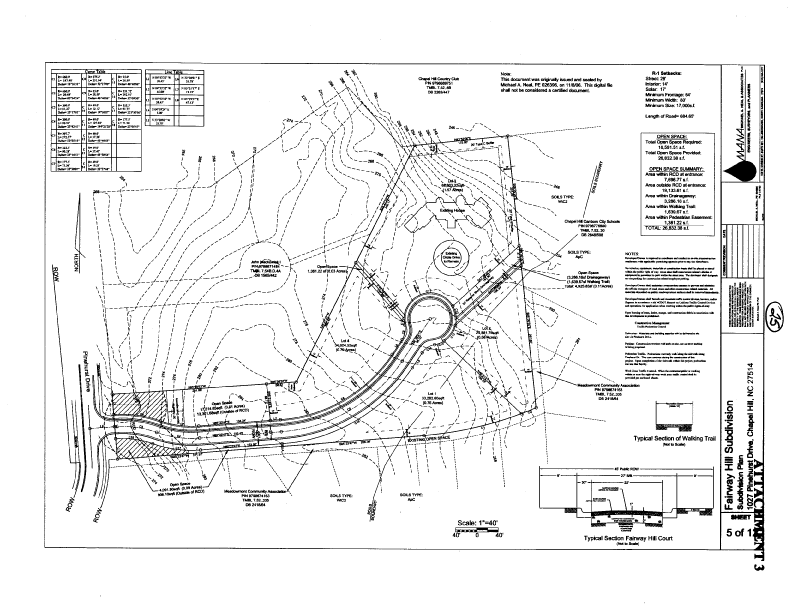
Subdivision Road Alignment: The applicant is proposing that the new subdivision road intersect Pinehurst Drive at approximately the same location as the existing driveway. The proposed alignment would enter the site in the middle and then curve to the southern portion of the site as shown by Attachment 3. This proposed roadway design provides room to accommodate stormwater management between the roadway and the adjoining properties to the north and south. The alignment also creates an open area (approximately 13,000 square feet) within the subdivision. The applicant is proposing to use this area to satisfy the Ordinance requirement for on-site recreation area.
Comment: We believe that the applicant’s proposed roadway design, provided as Attachment 3, including the intersection on Pinehurst Drive and internal roadway alignment, complies with the subdivision regulations, the standards of the Land Use Management Ordinance, and the Town’s Design Manual. For additional discussion, please refer to the section in this memorandum on roadway alignment options.
Compliance with Land Use Management Ordinance: At the Public Hearing, a citizen spoke in opposition to the application, stating the application was not in compliance with the Land Use Management Ordinance. The concerns included safety and security issues to residences on adjoining properties to the south. The citizen also expressed concern that vehicle headlights may shine onto adjacent residences in the Meadowmont development.
Comment: The standard of review and approval of a Preliminary Plat application involves comparing the application with the regulations and standards in the Land Use Management Ordinance. The review typically focuses on vehicular and pedestrian access and circulation, traffic impact, public improvements, lot standards, stormwater management, and recreation area. Chapel Hill’s regulations provide general guidance for new roadway location but do not specify road alignment as it relates to adjacent developed or undeveloped property. The regulations require that streets be provided and designed in accordance with the Design Manual. The Land Use Management Ordinance directs that if, after consideration of the information, the Council decides that the application meets all the applicable Land Use Management Ordinance requirements, the application must be approved. If the Council decides that the application does not meet all the applicable Land Use Management Ordinance requirements, the application accordingly must be denied.
We believe that the applicant’s proposed roadway design, provided as Attachment 3, including the intersection on Pinehurst Drive and internal roadway alignment, complies with the subdivision regulations, the applicable standards of the Land Use Management Ordinance, and the Town’s Design Manual.
In response to concern expressed during the Public Hearing, the applicant has offered to provide additional buffer plantings along the southern property line to reduce the impact of vehicle headlights shining into existing residences. We have included this as a stipulation in the Revised Resolution A.
ROADWAY ALIGNMENT OPTIONS
During the November 20 Public Hearing, the Council directed staff to return with a revised resolution that would approve the proposed subdivision with the street alignment through the center of the site.
We believe the two key issues central to the approval of this subdivision are the internal road location and the recreation area. The table and discussion below provide details on the road alignments and recreation area options for approval of this subdivision:
OPTIONS |
Roadway Alignment |
Recreation Area |
Buffer Along South Property Line |
|
Option 1A (Applicant’s Proposal) |
Road enters the site and curves to south |
On-site recreation area |
Yes (as proposed by applicant) |
|
Option 1B Revised Resolution A (Staff Recommendation) |
Road enters the site and curves to south (as proposed by the applicant) |
On-site recreation area and partial payment-in-lieu |
Yes (as proposed by applicant) |
|
Option 2A Planning Board and Transportation Board Recommendation) |
Road enters the site in straight line without curve to south |
On-site recreation area and partial payment-in-lieu |
Not proposed by applicant |
|
Option 2B
|
Road enters the site in straight line without curve to south |
On-site recreation area |
Not proposed by applicant |
OPTION 1 - Roadway Alignment Along South Property Line
OPTION 1A (Applicant’s Proposal): The application before the Council tonight proposes the internal subdivision road enter the site at the existing driveway location and then swing to the south as shown on Attachment 3. This alignment complies with the requirements of the Land Use Management Ordinance.
The applicant is proposing that a portion of the required 16,591 square feet of recreation area be satisfied by approximately 13,500 square feet of recreation area between the internal roadway and the north property line. The applicant is also proposing that the remainder of the required recreation area be satisfied by the area associated with the pedestrian path to the Aquabella development and the pedestrian path to the Meadowmont soccer field.
The applicant is also proposing that additional buffer plantings along the southern property line to reduce the impact of vehicle headlights shining into existing residences. With respect to the subdivision regulation, the Land Use Management Ordinance does not require a landscape buffer as proposed by the applicant.
OPTION 1B (Staff’s Recommendation): With respect to the roadway alignment, we recommend the alignment as proposed by the applicant with the road entering the site at the existing driveway location and then swinging to the south as shown on Attachment 3.
The required recreation area for this subdivision is 16,591 square feet. We believe that a portion of the recreation area can be satisfied with the two pedestrian paths. As discussed in the November 20 Public Hearing Memorandum, we continue to recommend that the remainder of the required recreation area be satisfied with a payment-in-lieu. This recommendation is included in Revised Resolution A.
We also recommend the buffer yard along the south property line, as proposed by the applicant, and have included this recommendation in Revised Resolution A.
Comment (Options 1A and 1B): We believe that the roadway alignment described in Option 1A and 1B complies with the subdivision requirements in the Land Use Management Ordinance.
With respect to recreation area requirements, we recommend that the Council require a payment-in-lieu for a portion of the required recreation area (Option 1B). Section 5.5.2 of the Land Use Management Ordinance offers the Council the ability to require an applicant to provide a payment-in-lieu for recreation area when the minimum recreation area required is less than two acres. In this case, the required recreation area is less than two acres. We believe that a portion of the recreation area (approximately 3,100 square feet) can be satisfied by recreation area associated with the two pedestrian paths. We recommend that the remainder of the required recreation area (approximately 13,500 square feet) be satisfied with a payment-in-lieu.
Alternately, the Council could make the determination that the 13,500 square feet of recreation area, as proposed by the applicant and identified as open space on Attachment 3, is appropriate and meets the suitability of land requirements of the Land Use Management Ordinance (Option 1A). If the Council desires to make such determination, the Council would replace Stipulation #12, in Revised Resolution A with the following language:
OPTION 1A – Alternate Language (if desired, replace stipulation #12)
Recreation Requirements: That the applicant shall provide on-site recreation area (a minimum of 16,591 square feet). That the proposed 13,500 square feet identified as open space between the internal roadway and the north property line, and the two pedestrian connections, located between Lots 2 and 3 and between Lots 3 and 4, shall be considered suitable recreation area. The recreation area shall be reviewed and approved by the Town Manager prior to the issuance of a Zoning Compliance Permit. The land shall be identified on the Final Plat and shall be deeded to the Homeowners’ Association concurrently with the recordation of the final plat.
Option 2 – Roadway Alignment in Center of Site
OPTION 2A (Planning Board and Transportation Board recommendation): During advisory board review of the proposed application, several citizens expressed concern with the location of the proposed subdivision roadway. Particular concern was expressed with the proposal to locate a portion of the roadway along the south property line adjacent to several existing residences. Also expressed was a concern with the amount of clearing required in order to construct the roadway in the proposed location.
In order to minimize clearing and tree removal on the site, the Planning Board and the Transportation Board recommended that the applicant relocate the proposed roadway to the center of the site and generally follow the current alignment of the existing residential driveway. This alignment was originally considered by the applicant during Concept Plan Review as indicated by Attachment 4.
With respect to the recreation area, the Planning Board and Transportation Board recommended a partial payment-in-lieu as recommended by staff.
OPTION 2B – Similar to Option 2A, this option includes a street alignment in the middle of the site. For recreation area, Option 2B includes a proposal to accept the area north and south of the internal roadway as on-site recreation area.
Comment (Option 2A and 2B): With respect to the locating the internal roadway in the center of the site (Attachment 4), we believe this alignment alternative would preserve the greatest number of trees present on the site. However, we note that the trees that would be preserved do not include any significant trees or tree stands as defined in the Land Use Management Ordinance.
Although a subdivision proposal that incorporates a roadway and recreation element as described in Option 2A and 2B, may comply with the Land Use Management Ordinance, the applicant’s proposal (Option 1) also complies with the Ordinance.
Based on discussions with the Town Attorney, if the Council desires to approve the application with the roadway alignment as shown on Attachment 4, the Council could stipulate this roadway alignment, if the applicant agrees to amend the application. As of tonight’s meeting, the applicant is not agreeable to this change. If the applicant agrees to amend the application, with respect to the roadway alignment, the Council could replace Stipulation #5 for the road location with the following stipulation if it wished to do so:
OPTION 2 – Alternate Language (if desired, replace stipulation #5)
New Road Location: That the new subdivision roadway shall intersect Pinehurst Drive approximately at the location of the existing driveway and shall be located as generally shown on the Concept Plan bisecting the portion of the site closest to Pinehurst Drive.
We also note that the Council could make the determination that area identified as open space on Attachment 4 is appropriate recreation area and meets the suitability of land requirements of the Land Use Management Ordinance. The Council could replace Stipulation #12 for a payment-in-lieu with the following stipulation if it wished to do so:
OPTION 2B – Alternate Language (if desired, replace stipulation #12)
Recreation Requirements: That the applicant shall provide on-site recreation area (a minimum of 16,591 square feet). That the proposed 13,500 square feet identified as open space along both sides of the internal roadway and the two pedestrian connections; located between Lots 2 and 3 and between Lots 3 and 4, shall be considered suitable recreation area. The recreation area shall be reviewed and approved by the Town Manager prior to the issuance of a Zoning Compliance Permit. The land shall be identified on the Final Plat and shall be deeded to the Homeowners’ Association concurrently with the recordation of the final plat.
RECOMMENDATIONS
Staff Recommendation: We recommend that the Council adopt Revised Resolution A, approving the application with conditions.
Resolution B would approve the application as recommended by the Planning Board and the Transportation Board.
Resolution C would approve the application as recommended by the Bicycle and Pedestrian Advisory Board.
Resolution D would approve the application as recommended by the Parks and Recreation Commission.
Resolution E would deny the application.
Fairway Hill Subdivision
Preliminary Plat
DIFFERENCES AMONG RESOLUTIONS
|
ISSUE |
Staff Revised Recommendation |
Planning Board and Transportation Board Recommendation |
Bicycle and Pedestrian Advisory Board Recommendation
|
Parks and Rec Commission Recommendation |
|
Pinehurst Drive Intersection
|
At the existing driveway curb cut |
At the existing driveway curb cut |
* (At the south property line)
|
* (At the south property line) |
|
Internal subdivision street alignment
|
As proposed by the applicant (Attachment 2)
|
Alignment to follow existing driveway (Attachment 1) |
* |
* |
|
Recreation Area |
Proportional payment-in lieu (credit for pedestrian paths)
|
Proportional payment-in lieu (credit for pedestrian paths) |
Proportional payment-in lieu (credit for pedestrian paths) |
Full payment-in-lieu |
Fairway Hill Subdivision
Preliminary Plat
DIFFERENCES AMONG RESOLUTIONS
|
ISSUE |
Staff Revised Recommendation |
Planning Board and Transportation Board Recommendation |
Bicycle and Pedestrian Advisory Board Recommendation
|
Parks and Rec Commission Recommendation |
|
Additional buffer plantings along southern property line |
Yes (as proposed by applicant) |
* |
* |
* |
|
Alternate Buffer at Chapel Hill Country Club
|
Yes |
Yes |
* |
* |
|
Pedestrian Path along south property line
|
No (relocate between lots 2 and 3) |
No (relocate between lots 2 and 3) |
* |
No (relocate between lots 2 and 3) |
* Item not discussed at this particular meeting and is therefore not included in the Resolution.
ATTACHMENTS