|
MEMORANDUM |
|
|
TO: |
Roger L. Stancil, Town Manager |
|
FROM: |
J.B. Culpepper, Planning Director Gene Poveromo, Development Coordinator |
|
SUBJECT: |
Bradley Ridge Preliminary Plat Cluster Subdivision (File No. 9880-96-7441) |
|
DATE: |
February 25, 2008 |
INTRODUCTION
The 37.2 acre Bradley Ridge Cluster Subdivision is located on the east side of Sunrise Road, between Sweeten Creek Road and Interstate 40. A portion of the site is located in the Resource Conservation District. The site is located in the Residential-2 (R-2) zoning district, within the Urban Service Boundary and outside Town limits, in the Town’s Joint Planning Area. The property is located in Orange County and is identified as Parcel Identifier Numbers 9880-96-7441; 9890-06-0413; 9890-06-3350; 9890-06-5926; 9890-06-6312; and 9890-16-0437.
DISCUSSION
Several questions and concerns were expressed during the January 23, 2008 Public Hearing. Each is discussed below.
1. Status of Ginger Road right-of-way: The Bradley Ridge development includes a proposal to abandon the gravel portion of Ginger Road west of Amesbury Drive. A Council member asked staff what would be the status of the remaining portion of the unimproved section of Ginger Road, east of Amesbury Drive that is not proposed to be abandoned.
Comment: Ginger Road is outside the Town’s extraterritorial planning jurisdiction, within the Joint Planning Area. Closure of this right of way would therefore be handled by Orange County under a statutory procedure (N.C. General Statute Sec. 153A-241) similar to the procedure in N.C.G.S. Sec. 160A-299 for streets within the Town’s jurisdiction. Upon closing of a public road, title to the right of way is vested in persons owning lots adjacent to the road on either side, extending to the center line of the road. If Orange County agrees to abandon the portion of Ginger Road, between Sunrise Road and Amesbury Drive, we anticipate that approximately 30 feet of the 60 foot wide right of way would be vested to adjacent property owners on each side of the roadway.
The Bradley Ridge development does not include a proposal to abandon the unimproved portion of Ginger Road east of Amesbury Drive. We believe that this unimproved portion of Ginger Road permits access to the property at the eastern end of the right-of-way. This area will remain as unimproved public right-of-way until such time that it is either abandoned or improved to provide access to the adjacent property.
2. Amesbury Drive connection: A citizen from the Chandler Green neighborhood requested that the Council amend the staff recommended stipulation to prohibit all traffic from using Amesbury Drive until such time that all infrastructure is complete and all homes are built.
Comment: We do not believe it is either reasonable or desirable to keep this roadway closed until all homes are built. We believe that once infrastructure (streets, sewer and water lines, stormwater basins) construction is complete that this connector road should allow unrestricted vehicular travel between Chandler View and the proposed development.
The attached Resolution authorizes the opening of this connector roadway once the infrastructure construction is completed. The attached Resolution also includes a stipulation prohibiting infrastructure construction traffic from Chandler Green, except for construction associated with the extension of an OWASA sewer line located within the Chandler Green neighborhood.
3. Pedestrian Path Signage: A Council member noted that the resolution did not include a stipulation addressing the Town’s involvement in the long term maintenance of pedestrian path signage installed by the Homeowners Association.
Comment: The Engineering and Planning Departments are currently preparing a map identifying the location of signs informing neighbors of future connector roads and pedestrian path-trail signs. We anticipate returning to the Council at the March 17th meeting with additional information and recommendations on this program.
4. Payment-in-lieu for solar power at bus shelter: The Chapel Hill Transportation Board recommended that the stipulated transit improvement (payment in lieu of $6,500 for a bus stop, shelter and bench) include additional provisions for solar power, not to exceed $2,000 in cost. A Council member asked staff if the solar power improvements envisioned by the Transportation Board included a “real-time” schedule board.
Comment: This location would not be expected to have the passenger volume to justify installation of real time displays. The payment-in-lieu would be used for solar power lighting. Revised Resolution A includes a revised stipulation that increases the recommended payment-in-lieu from $6,500 to $8,500 in order to provide solar power improvements.
5. Implementation of transit service and number of recommended bus stops: In light of the fact that the transit payment-in-lieu is stipulated to be spent within a prescribed time period (five years after the 31st Certificate of Occupancy), a Council member asked the staff to describe when transit service would be extended to this area of the community. The Council members also asked the staff to explain why the recommendation did not include a payment for an outbound (northbound from Weaver Dairy Road) bus shelter.
Comment: In response to the above, the Town’s Director of Transportation offers the following comment:
“The question of when service would be extended is dependent upon annexation, for which there is not timetable, and possible transit service realignments. I also think the extension of service is related to budget and service priorities. In this day of tight budgets I don’t think it is reasonable to assume that just because an area is annexed it will be receiving transit service in the immediate future. The most cost effective way to introduce service to a new area is by realigning or extending service. Although this can be cost effective it may not be efficient as it can increase travel time or cause the routes to become confusing or circuitous…thus discouraging ridership growth…Looking at new developments the issue of access and the ability to capture riders is an issue…if access does not encourage transit usage then ridership projections would be lower and the resulting priority of that service extension compared to others may fall.
So, the extension of service can be dependent on funding availability, service/budget priorities and the ability of the system to effectively serve an area.
With respect to an outbound bus shelter issue the project is located at the end of our anticipated service area along Sunrise. Looking at their site plan I think the outbound trip might be routed through Chandler Green and then into Bradley Green and out to Sunrise so the bus can turn around. There is no need for an outbound shelter/bench since no one would be waiting there.”
6. Future financial sustainability and affordable housing: A Council member expressed concern with the long term sustainability of the affordable housing component. Of particular concern was the future financial burden to the individual home owners as it relates to increased property taxes as a result of annexation, and the continued cost associated with home maintenance.
Comment: The applicant has provided a letter (attached) responding to this concern.
7. Courtesy comments on construction management plan: In light of the fact that the Chapel Hill cross country team members train along Sunrise Road, a citizen suggested that the Council stipulate a condition that permits courtesy comments from the principal of East Chapel Hill High and the school’s Director or Transportation.
Comment: Revised Resolution A includes a stipulation that offers the construction management plan to the principal of East Chapel Hill High and the school’s Director of Transportation for courtesy comments prior to the issuance of a Zoning Compliance Permit.
8. Use of recreation payment-in-lieu funds for sidewalk construction: In response to a comment by a citizen, a Council member asked the staff if a portion of the proposed $140,000 payment-in-lieu for recreation area could be used to construct a missing sidewalk segment along the east side of Sunrise Road, between Ginger Road and Sweeten Creek Road.
Comment: The Land Use Management Ordinance requires that active recreation space or a payment in lieu of active recreation space be provided. The staff can not recall any situation in which the Town considered sidewalk construction as active recreation. We believe that payment in lieu of recreation space under state law must be used for recreation purposes. Revised Resolution A does not include a recommend that a portion of the recreation payment-in-lieu funds be used for sidewalk construction.
We understand that the applicant is willing to construct this sidewalk segment along the east side of Sunrise Road, between Sweeten Creek Road and Ginger Road. Revised Resolution A includes a stipulation requiring the applicant to construct this sidewalk segment.
9. Stream Classification, Hydrology and Stormwater Management: A citizen expressed concern with the following: a) That the stream classification of an intermittent stream was incorrect; b) That home construction on some lots is unsuitable due to existing hydrological conditions; and c) That the proposed stormwater management plan will eliminate a wetlands, and negatively impact stormwater quality. The citizen recommended that the applicant conduct soil boring studies, avoid building on several of the affordable lots and incorporate the existing hydrological environment into the water quality treatment.
Comment: Responses to the issues presented, some of which were provided previously to the Planning Board and Council, are included below.
Stream Determination: Town staff made two field visits to the site for purposes of conducting a stream determination. The first inspection in 2003 classified a drainageway in the eastern portion of the site as “intermittent.” The applicant appealed the “intermittent” classification and a second inspection was made in 2004. This inspection determined that the area in question could not be classified as an intermittent stream because there was no evidence that it was hydrologically connected to the downgradient stream network. Therefore, the Resource Conservation District buffer requirements were not applicable.
The Town staff were trained and certified to conduct the stream determinations. The North Carolina Division of Water Quality’s (NC DWQ) “Identification Methods for the Origins of Intermittent and Perennial Streams” protocol was used in conjunction with the Town’s “Field Procedures for Classification of Streams,” dated October 20, 2003, and revised October 31, 2003. The Town’s supplemental procedures were adopted to protect stream segments that had been disconnected as a result of a manmade change, such as piping the stream or grading and filling the channel.
Staff found no evidence of a channel or a surface/subsurface connection between the downgradient stream and the upland, isolated drainageway. Further, there were no wrack lines, sand/silt deposits, or obligate plants.
Much has been made by the residents of the presence of flowing water, during and immediately after the December 30-31st rain event. The residents conclude that flowing water must be indicative of a connection. Water flows off residential yards but that alone does not indicate that the front yard is a stream and is subject to the RCD requirements.
As noted in the NC DWQ manual …“The rate and duration of flow in stream channels is influenced by climate and by recent weather. Recent (within 48 hours) rainfall can influence scoring; therefore it is strongly recommended that field evaluations be conducted at least 48 hours after the last known rainfall.” The Town’s procedures require a minimum of 48 hours between the end of a rain event and a stream determination field visit. (Source: NC Division of Water Quality. 2005. Identification Methods for the Origins of Intermittent and Perennial Streams, Version 3.1. North Carolina Department of Environment and Natural Resources, Division of Water Quality. Raleigh, NC.)
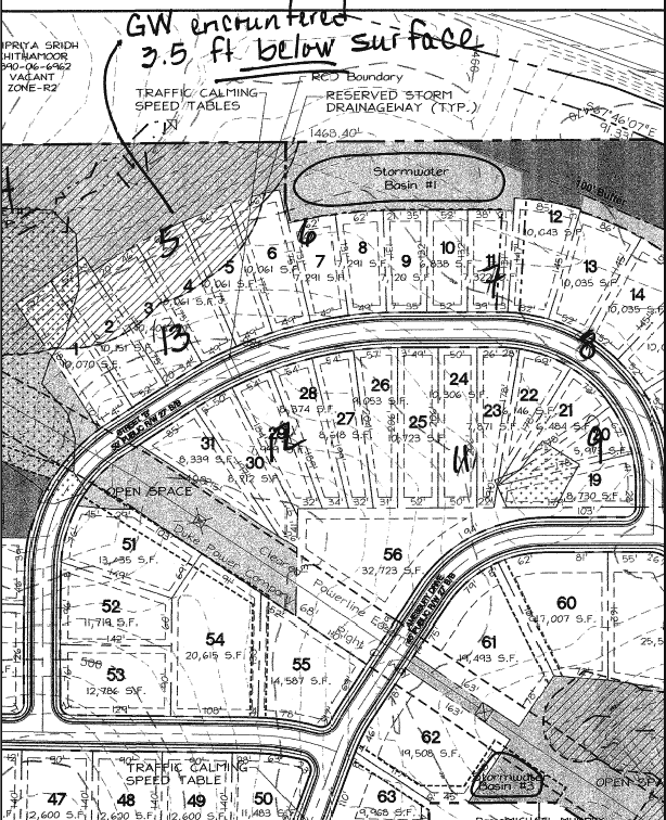
Unsuitable Lots: Based on the observation of flowing and standing water, residents have concluded that several of the lots are unsuitable for construction. Staff transferred the locations of the soil borings conducted by GeoTechnologies for Habitat from a previous site plan to the current site plan. Groundwater was encountered at only one of the boring locations (B-5), 3.5 feet below the surface. This boring is located approximately along the rear boundary of Lot 4. Groundwater was not encountered in the borings in the vicinity of the proposed Stormwater Basin 1 or Lots 12 and 13 (attached). Town staff’s comments that disturbance should be avoided or minimized was not intended to be interpreted as a prohibition against construction. There are limitations and challenges but these can be overcome through design and construction modifications.
Staff understands that the applicant is willing to delay construction on Lots 12 and 13.
Wetlands and Water Quality: The wetland area referred to is a small, isolated upland wetland. The US Army Corps of Engineers staff determined that it was not a jurisdictional wetland and was not subject to the Clean Water Act Section 404 wetland permitting requirements and the state’s accompanying 401 Water Quality Certification. By virtue of the land development activity, the water quality will be affected. However, the Town’s Land Use Management Ordinance contains requirements to address the post-development water quality.
The residents have been informed that these are not final construction plans and that detailed stormwater design calculations and plans will be required as part of the Final Plan Zoning Compliance Permit submittal. At that time, a detailed and comprehensive review of the design and supporting calculations will be conducted to ensure that they comply with the stormwater management requirements contained in the Town’s Land Use Management Ordinance, the Town Design Manual, and applicable State criteria.
Staff supports the applicant’s stipulation concerning the delayed construction on Lots 12 and 13.
10. No-Parking Signs: During the Public Hearing a citizen living in the Chandler Green neighborhood expressed a concern with how the Town will enforce the No-Parking regulations. The President of Habitat Orange County also expressed a concern about the use of No-Parking regulations in the affordable housing section of the neighborhood. He was particularly concerned that the No-Parking provision would not provide on-street parking for visitors.
Comment: The Town cannot enforce on-street parking regulations on the streets within the proposed Bradley Ridge neighborhood until it is annexed into the Town. Until such time parking regulations within this proposed development are subject to approval NCDOT. We suggest that the applicant discuss this with NCDOT staff during the final plan review. The attached resolution continues to stipulate that the applicant install no-parking sign, subject to NCDOT approval.
11. Home construction phasing plan: In order to address the concern that some affordable lots might be unsuitable home sites due to hydrological conditions, a citizen suggested that the Town Council add a stipulation that would delay the construction on these lots until a later phase of development. The citizen also suggest that prior to issuing building permits for these lots that the Town require a soil analysis or similar documentation addressing if the site is suitable for home construction.
Comment: The applicant has agreed to defer building homes on lots 12 and 13 such that they will be in the last 20% of the affordable homes that are built on lots 1-31. This has been incorporated into Revised Resolution A.
RECOMMENDATIONS
Transportation Board: The Transportation Board reviewed this subdivision proposal on January 10, 2008. The Board voted 5 to 0 to approve the application with the adoption of the Resolution attached to the Advisory Board memorandum, with the following change:
Comment: This recommendation is incorporated into Revised Resolution A. Please refer to the Discussion section of this memorandum for additional information.
Bicycle and Pedestrian Advisory Board: The Bicycle and Pedestrian Advisory Board reviewed this subdivision proposal on January 22, 2008. The Board voted 9 to 0 to approve the application with the adoption of Resolution attached to Advisory Board memorandum with the following change:
Comment: The attached resolution includes a stipulation for a payment-in-lieu for a bus stop, bench, shelter and solar power. We anticipate that this bus stop will be located on the west side of Weaver Dairy Road, south of the entrance into the Carol Wood YMCA. We recommend that the applicant provided an additional payment-in-lieu for a sidewalk, along the west side of Weaver Dairy Road, between the Carol Wood YMCA driveway and the bus stop. We recommend that the location of the bus stop and the payment-in-lieu amount be determined by the Town Manager prior to the issuance of a Zoning Compliance Permit. This recommendation has been incorporated into Revised Resolution A.
Greenways Commission: The Greenways Commission reviewed this subdivision proposal on January 23, 2008. The Board voted 5 to 0 to approve the application with the adoption of Resolution attached to Advisory Board memorandum with the following change:
Comment: We have not determined if the area between the north property line and the proposed lots includes an appropriate location for a future greenway. However, we believe it would be beneficial for the Town to obtain a blanket greenway easement over this open area prior to the approval of a Zoning Compliance Permit. At such time that the Town proceeds with the design and construction of the Interstate 40 Greenway, we can then determine if this property is suitable for the greenway. We have incorporated this recommendation into Revised Resolution A.
Our preliminary recommendation from January 23, 2008 and recommendations from other Advisory Board are discussed in the January 23, 2008 memorandum.
Revised Staff Recommendation: We recommend that the Council approve the Preliminary Plat application with the conditions listed in Revised Resolution A.
Following the January 23 Public Hearing and review by the Transportation and Bicycle and Pedestrian Advisory Boards, the below changes have been incorporated into Revised Resolution A.
Revised Resolution A would approve the application with conditions. Resolution B would deny the application
A copy of a matrix comparing the differences between the above recommendations is included at the end of this memorandum.
PROCESS
This is a Major Subdivision application requesting a Preliminary Plat approval. The Land Use Management Ordinance requires the Town Manager to conduct an evaluation of a Preliminary Plat application, to present a report to the Planning Board, and to present a report and recommendation to the Town Council. We have reviewed the application and evaluated it against Town standards. We have presented a report to the Planning Board and tonight we submit our report and recommendation to the Council.
Review of subdivision proposals differs from review of Special Use Permits in that the question of compliance with regulations and standards is the basis for approval or denial, rather than the four findings of fact listing in Section 4.5.2 of the Land Use Management Ordinance. However, the Council’s review and action on a subdivision is quasi-judicial, with sworn testimony and evidence entered into the record. Please see the attached summary of key differences between legislative and quasi-judicial zoning decisions, prepared by Mr. David Owens of the School of Government.
The standard of review and approval of a Preliminary Plat application involves comparing the application with the regulations and standards in the Land Use Management Ordinance. The review typically focuses on vehicular and pedestrian access and circulation, traffic impact, public improvements, lot standards, and recreation area.
Information regarding this application will be presented at tonight’s public hearing. The Land Use Management Ordinance directs that if, after consideration of the information, the Council decides that the application meets all the Land Use Management Ordinance requirements, the application must be approved. If the Council decides that the application does not meet all the Land Use Management Ordinance requirements, the application accordingly must be denied.
EVALUATION OF THE APPLICATION
We have evaluated the application regarding its compliance with the subdivision standards and regulations of the Town’s Land Use Management Ordinance. Based on our evaluation, our recommendation is that the application, as submitted, complies with the regulations and standards of the Land Use Management Ordinance and Design Manual, with the conditions in Resolution A.
The Council may find that the proposal meets the subdivision regulations and other pertinent Town regulations, or may find that the proposal does not meet the regulations [Resolution B]. Please refer to the Staff Report from January 23, 2008 for detail on compliance with subdivision regulations.
Tonight, the Council receives our attached evaluation, and also receives information submitted by the applicant and citizens. The applicant’s materials are included as attachments to this memorandum. All information that is submitted at the hearing will be included in the record.
SUMMARY
We have attached a revised resolution that includes standard conditions of approval as well as special conditions that we recommend. The key special conditions that we recommend are described in detail in the accompanying report. With these conditions, we believe that the Council could adopt a resolution to approve the application for a subdivision. The Manager’s recommendation incorporates input from all Town departments involved in review of the application.
BRADLEY RIDGE CLUSTER SUBDIVISION Differences Between Recommendations
|
ISSUE |
Staff Revised |
Planning Board |
Parks & Rec. |
Transportation |
Bicycle & Pedestrian |
Greenways |
|
Traffic calming on Amesbury |
Yes, before opening to development |
* |
* |
* |
* |
|
|
Sidewalk on eastside Sunrise Rd frontage |
No |
* |
* |
* |
* |
|
|
Refund bus stop/shelter payment |
Yes, within 5 yrs of 30th certificate of occupancy |
* |
* |
* |
* |
|
|
Delete pedestrian path to southeast |
Yes |
* |
* |
* |
* |
|
|
Limit disturbance in RCD |
Yes, limit to upland zone |
* |
* |
* |
* |
|
|
Prohibit construction traffic on Ginger and in Chandler Green until infrastructure complete |
Yes – except for sewer line extension within Chandler Green |
Yes |
* |
* |
* |
* |
|
Fencing around detention pond |
Yes |
* |
* |
* |
* |
|
|
No parking signs |
Yes (to be maintained by the HOA until annexation) |
* |
* |
* |
* |
|
|
Pedestrian path between rec. areas |
Yes |
* |
Yes |
* |
* |
* |
|
$2,000 payment for solar power at bus shelter |
Yes |
* |
* |
Yes |
* |
* |
|
Sidewalk to bus shelter on Sunrise Rd |
Yes (payment-in-lieu) |
* |
* |
* |
Yes (payment-in-lieu) |
* |
|
Courtesy commets from ECHH on const mang plan |
Yes |
* |
* |
* |
* |
* |
|
Grnway esmt btwn Sunnrise and east property |
Yes |
|
|
|
|
Yes |
|
Sidewalk between Ginger and Sweeten Creek |
Yes |
* |
*
|
* |
* |
* |
|
Delay Construction on lot 12 & 13 |
Yes |
* |
* |
* |
* |
* |
* Item not discussed at the meeting or included as a recommended change to the resolution
ATTACHMENTS
ADDITIONAL INFORMATION (February 25, 2008)