AGENDA #3c
to: Roger L. Stancil, Town Manager
from: J.B. Culpepper, Planning Director
Gene Poveromo, Development Manager
George Small, Engineering Director
Kumar Neppalli, Engineer Services Manager
subject: Public Hearing: Woodmont on NC 54 East Phase I Special Use Permit
date: May 12, 2008
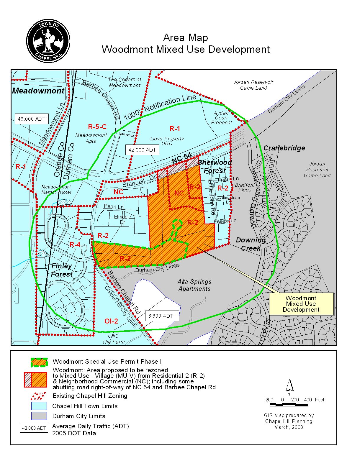
Attached for your consideration is a proposal from Capital Associates for a Special Use Permit to allow a mixed use development on 14.25 acres with 95,000 square feet of office use; 88,900 square feet of residential use; and 404 parking spaces. Accompanying this application are applications for a Master Land Use Plan and Zoning Atlas Amendment. The site is identified as Durham County Parcel Identifier Numbers 9798-04-93-2035, 9798-04-92-0930, 9798-04-82-9499, 9798-04-82-6093, 9798-04-81-1816, 9798-04-71-8729, and 9798-04-82-6534.
The Special Use Permit is Phase I of the Master Land Use Plan and its boundaries are shown on the Site Plan. The boundary shown on the Master Land Use Plan Phasing Plan is different because it shows all three proposed phases, and the Phase III boundary incorporates a portion of what would have formerly been Phase I.
During staff and advisory board review we identified three key issues related to this project:
1. Traffic Impacts on NC 54 and Barbee Chapel Road: Concerns were voiced at the Planning Board meetings regarding the capacity of Barbee Chapel Road and NC 54 to handle additional traffic.
Comment: We rely on the results of the Traffic Impact Analysis to determine our transportation recommendations for development. As described in the Master Land Use Plan memorandum, the recommended improvements from the Traffic Impact Analysis are projected to change the level of service (LOS) from existing “E” for the AM peak hour to LOS “D” for the AM peak hour, and from LOS “B” for the PM peak hour to LOS “C” for the PM peak hour.
For more information about the projected impacts on existing capacity, please refer to both the Traffic Impact Analysis and Comprehensive Traffic Analysis for Woodmont and Aydan Court attached.
2. Comprehensive Plan: During Planning Board review of the applications, a neighbor expressed concern about the Special Use Permit finding regarding compliance with the Comprehensive Plan. The neighbor specifically referenced the NC 54 East Entranceway Study. We have attached a copy of the NC 54 Entranceway Study.
Comment: In order to approve the Master Land Use Plan application, the Council must make three findings, one of which is regarding consistency with the Comprehensive Plan. The Comprehensive Plan includes a number of documents. In 1995, the NC 54 East Entranceway Study was adopted as a component of the Comprehensive Plan. We believe that arguments can be made that the application complies with the NC 54 East Entranceway Study and arguments can be made that it does not comply with the study. Please refer to the NC 54 East Entranceway Study attachment as well as April 1, 2008 memorandum from the applicant and March 18, 2008 memorandum from Sherwood Forest Residents for arguments for and against the development’s support of the Entranceway Study goals.
We believe the Woodmont development proposal could be found to achieve a number of objectives identified in the themes of the 2000 Comprehensive Plan, including:
3. Mix of Uses: At the April 1, 2008 Planning Board meeting, Planning Board members questioned the mix of uses proposed for the Phase I Special Use Permit application. Although the proposal meets the thresholds for “mixed use” established in the Mixed Use-Village section of the ordinance (at least 25% residential floor area and at least 25% office or retail floor area), members expressed concern that the development may not have an adequate mix of uses. Members expressed concern that instead of creating a vibrant and dynamic mixed use urban atmosphere, the application creates an atmosphere for residents of living in an empty suburban office park.
Comment: The “Mixed Use-Village” zoning designation requires that the mix of floor area within a proposed development shall contain at least twenty-five (25) per cent of the floor area devoted to residential uses and at least twenty-five (25) per cent of the floor area devoted to office/commercial uses. During advisory board review, the applicant proposed to introduce a greater amount of retail and restaurant type uses. In order to evaluate the Woodmont proposal we believe it is appropriate to view the proposal in the context of the larger geographic area which includes the adjacent residential developments, and potential nearby retail redevelopment. The opportunity will exist for people to walk to work and to retail and other commercial establishments.
As for the lack of retail that might serve residents after business hours (when the offices close), we understand that the applicant has proposed additional retail for Phase I and will provide that information at tonight’s meeting. We recommend the inclusion of 5,000-8,000 square feet of additional retail floor area in the Phase I Special Use Permit Resolution A.
Planning Board: The Planning Board has met several times to review the application, and we anticipate handing out their recommendation at tonight’s public hearing.
Bicycle and Pedestrian Advisory Board: The Bicycle and Pedestrian Advisory Board met on March 25, 2008 and voted 7-0 to recommend that the Council approve the Special Use Permit with the adoption of the Resolution attached to the Advisory Board memorandum with the following changes:
Comment: Resolution A includes the ordinance requirement for 52 bicycle parking spaces. The staff has not incorporated the recommended change into revised Resolution A.
Comment: We have not incorporated this change into Resolution A.
A copy of the Bicycle and Pedestrian Advisory Board Summary of Action is attached.
Greenways Commission: The Greenways Commission met on March 26, 2008 and the Commission voted (5-0) to recommend approval of the Special Use Permit with added language that would allow a payment in lieu for unmet recreation space requirements, if needed. A copy of the Greenways Commission Summary of Action is attached.
Comment: We have incorporated this change into Resolution A.
Community Design Commission: The Community Design Commission met on April 16, 2008 and voted (8-0) to recommend approval of the Special Use Permit with Resolution A, including an additional stipulation for 5,000-8,000 square feet of retail floor area (all in Phase I). A copy of the Community Design Commission Summary of Action is attached.
Comment: We have incorporated a stipulation for a minimum of 5,000 square feet of retail into Resolution A.
Parks and Recreation Commission: The Parks and Recreation Commission met on April 16, 2008 and voted (8-1) to recommend approval of the Special Use Permit with wording added to Resolution A that would allow a payment-in-lieu for recreation space in the event that conditions change and the developer elects to make a partial payment.
A copy of the Parks and Recreation Commission Summary of Action is attached.
Transportation Board: The Transportation Board met on April 24, 2008 and voted 4-1 to recommend approval of Resolution A.
Following Advisory Board review, no changes have been incorporated into Resolution A.
A copy of a matrix comparing the differences between the above recommendations is included at the end of this memorandum.
The Land Use Management Ordinance requires the Town Manager to conduct an evaluation of this Special Use Permit application, to present a report to the Planning Board, and to present a report and recommendation to the Town Council. We have reviewed the application and evaluated it against Town standards; we have presented a report to the Planning Board; and tonight we submit our report and preliminary recommendation to the Council.
The Land Use Management Ordinance states that “if a Master Land Use Plan is approved for a tract of land, and an application for a Special Use Permit is subsequently received, then the Special Use Permit application must be consistent with the Master Plan. If it is consistent with the Master Plan, a rebuttable presumption shall thereby be established that the proposed development would:
These are three of the four findings that must be made to approve an application for Special Use Permit. The fourth finding, “that the use or development complies with all required regulations and standards of this chapter, including all applicable provisions of articles 3 and 5, the applicable specific standards contained in the supplemental use regulations (article 6), and with all other applicable regulations,” is the only finding that must then be made by the Council in order to approve the Special Use Permit application with an approved Master Land Use Plan.
We have evaluated the application regarding its compliance with the Master Land Use Plan and standards and regulations of the Town’s Land Use Management Ordinance. Based on our evaluation, our preliminary conclusion is that the application as submitted complies with the Master Land Use Plan and the regulations and standards of the Land Use Management Ordinance, and Design Manual, with the conditions included in Resolution A.
Tonight the Council receives our attached evaluation and information submitted by the applicant. The applicant’s materials are included as attachments to this memorandum. All information that is submitted at the hearing will be included in the record of the hearing. Based on the evidence that is submitted, the Council will consider whether or not it can make the one finding:
|
Special Use Permit – Required Finding of Fact Finding #4: That the use or development complies with all required regulations and standards of the Land Use Management Ordinance. |
Following the Public Hearing, we will prepare an evaluation of the evidence submitted in support of and in opposition to this application.
We have attached a resolution that includes standard conditions of approval as well as special conditions that we recommend for this application. With approval of the rezoning requested, the Master Land Use Plan, and these conditions, our preliminary recommendation is that the Council could make the finding necessary in order to approve the application for the Special Use Permit. Our recommendation, Resolution A, incorporates input from all Town departments involved in review of the application.
Woodmont Special Use Permit Application
DIFFERENCES AMONG RECOMMENDATIONS
|
ISSUES |
Staff’s Preliminary |
Planning Board |
Bike/Ped Adv Bd |
Greenways Commission |
Parks/Rec Commission |
Community Design Commission |
Transportation Board |
|
Minimum Bicycle Parking Spaces |
52 (no changes to plan) |
52 (no changes to plan) |
60 |
52 (no changes to plan) |
52 (no changes to plan) |
52 (no changes to plan) |
* |
|
Angled Parking |
no |
* |
yes |
* |
* |
* |
* |
|
Recreation Space Payment-in-lieu |
yes |
* |
* |
yes |
yes |
* |
* |
|
Additional Retail (5,000-8,000 SF) |
yes |
* |
* |
* |
* |
yes |
* |
|
Park and Ride spaces |
yes |
* |
* |
* |
* |
* |
* |
* = Issues not discussed, and therefore not included in the Resolution