AGENDA #6b
MEMORANDUM
TO: Mayor and Town Council
FROM: W. Calvin Horton, Town Manager
SUBJECT: Rusch Hollow- Application for Special Use Permit
DATE: November 10, 2003
INTRODUCTION
Tonight the Council continues the Public Hearing from September 15, 2003, regarding the Special Use Permit for a multi-family development containing 12 single family dwelling units, a two unit structure and a three unit structure. The 3.2 acre site is located on the east side of Rogers Road, between Purefoy Road and Rusch Road. Proposed access to the site is from Rogers Road and from the east end of Rusch Road. The tract is located in Orange County, outside the Town Limits of Chapel Hill, and is identified as Chapel Hill Township Tax Map 23, Block D, Lots 14, 15, and 20.
Accompanying this request is an application to rezone the site from Residential-1 (R-1) to Residential-Special Standards-Conditional (R-SS-C).
On April 8, 2002, the Town Council approved a request from Habitat for Humanity for expedited processing of the proposed Rusch development.
This package of materials has been prepared for the Town Council’s consideration, and is organized as follows:
· Cover Memorandum: Provides background on the development proposal and the Town’s review process, and offers recommendations for Council action.
· Attachments: Includes resolutions of approval and denial, and a copy of the Public Hearing memorandum and its related attachments.
BACKGROUND
A Concept Plan Review of this application was conducted by the Community Design Commission on March 25, 2002. The submission of the Special Use Permit application for this proposed development preceded the requirement for Concept Plan Review by the Council and also does not meet the threshold for Council review of a Concept Plan. On April 8, 2002, the Council granted expedited process to Habitat for Humanity for this project. On September 15, 2003, a Public Hearing was held for consideration of a Special Use Permit application to authorize a multi-family development containing 12 single family dwelling units, a two unit structure and a three unit structure on a 3.2 acre site is located on the east side of Rogers Road, between Purefoy Road and Rusch Road. Questions regarding the application were raised during the Public Hearing, and the Hearing is being reopened tonight to receive applicant and staff responses to these questions.
This is an application for a Special Use Permit. The Land Use Management Ordinance requires the Town Manager to conduct an evaluation of this Special Use Permit application, to present a report to the Planning Board, and to present a report and recommendation to the Town Council. We have reviewed the application and evaluated it regarding its compliance with the standards and regulations of the Town’s Land Use Management Ordinance; we have presented a report to the Planning Board; and on September 15, we submitted our report and recommendation to the Council.
EVALUATION OF THE APPLICATION
The standard for review and approval of a Special Use Permit application involves consideration of four findings of fact that the Council must consider for granting a Special Use Permit. Based on the evidence that is accumulated during the Public Hearing, the Council will consider whether or not it can make each of the four required findings for the approval of a Special Use Permit.
If, after consideration of the evidence submitted at the Public Hearing, the Council decides that it can make each of the four findings, the Land Use Management Ordinance directs that the Special Use Permit shall then be approved. If the Council decides that the evidence does not support making one or more of the findings, then the application cannot be approved and, accordingly, should be denied by the Council.
Tonight, based on the evidence presently in the record thus far, we provide the following evaluation of this application based around the four findings of facts that the Council must consider for granting a Special Use Permit.
|
Finding #1: That the use or development is located, designed, and proposed to be operated so as to maintain or promote the public health, safety, and general welfare.
|
Staff Comment: We believe the evidence in the record to date can be summarized as follows:
Evidence in support: Evidence in support of Finding #1, as offered in the attached applicant’s Statement of Justification (provided as an attachment to the September 15, 2003 memorandum) can be summarized as follows:
“This subdivision will:
Additional arguments presented by the applicant in support of this finding are offered in the attached Statement of Justification.
Evidence in opposition: We have not identified any evidence offered in opposition to Finding #1.
|
Finding #2: That the use or development complies with all required regulations and standards of this chapter, including all applicable provisions of Articles 3 and 5, the applicable specific standards in the Supplemental Use Regulations (Article 6) and with all other applicable regulations.
|
Staff Comment: We believe the evidence in the record to date can be summarized as follows:
Evidence in support: Evidence in support of Finding #2, as offered in the attached applicant’s Statement of Justification (provided as an attachment to the September 15, 2003 memorandum) can be summarized as follows:
“The proposed subdivision will”
· “Comply with the required regulations and standards of this Chapter, including all applicable provisions of Articles 3 and 5 and the applicable specific standards contained in the Supplemental Use Regulations (Article 6), and with all other applicable regulations.” [Applicants Statement]
· “Promote the development of affordable housing.” [Applicants Statement]
Additional arguments presented by the applicant in support of this finding are offered in the attached Statement of Justification.
Evidence in opposition: Evidence in opposition of Finding #2 for this application would include the fact that, if the accompanying Zoning Atlas Amendment application is not approved, the proposed development will not meet the Land Use Management Ordinance for maximum floor area, minimum lot size, minimum lot width, minimum recreation space, maximum dwelling units, setbacks, or landscape buffers.
|
Finding #3: That the use or development is located, designed, and proposed to be operated so as to maintain or enhance the value of contiguous property, or that the use or development is a public necessity;
|
Staff Comment: We believe the evidence in the record to date can be summarized as follows:
Evidence in support: Evidence in support of Finding #3, as offered in the attached applicant’s Statement of Justification (provided as an attachment to the September 15, 2003 memorandum) can be summarized as follows:
“This development will:
Additional arguments presented by the applicant in support of this finding are offered in the attached Statement of Justification.
Evidence in opposition: We have not identified any evidence offered in opposition to Finding #3.
|
Finding #4: That the use or development conforms with the general plans for the physical development of the Town as embodied in this chapter and in the Comprehensive Plan.
|
Staff Comment: We believe the evidence in the record to date can be summarized as follows:
Evidence in support: Evidence in support of Finding #4, as offered in the attached applicant’s Statement of Justification (provided as an attachment to the September 15, 2003 memorandum) can be summarized as follows:
“This project will:
· Add 12 single-family homes and 5 rental units for disabled and/or elderly citizens. All of the units will be affordable for 99 years to households earning at or below 50% of the area median income.” [Applicant’s Statement]
· “Further extend sanitary sewer in the Rogers Road community and make sewer easily accessible to the portion of the Greene Tract (approximately 18 acres) that has been designated for affordable housing.” [Applicant’s Statement]
· Contribute to a mix of housing in the Rogers Road community, which is already comprised of a mix of mobile homes, twelve recently constructed Habitat for Humanity Orange County single-family homes, a number of modest older single-family homes, and a range of more expensive single-family homes.” [Applicant’s Statement]
· “Contribute to the revitalization of the Rogers Road community by providing attractive in-fill housing at a slightly higher density than the rest of the community.” [Applicant’s Statement]
· “Actively recruited public housing residents as applicants, and has successfully worked with public housing residents to overcome the barriers to homeownership.” [Applicant’s Statement]
Additional arguments presented by the applicant in support of this finding are offered in the attached Statement of Justification.
Evidence in opposition: We have not identified any evidence offered in opposition to Finding #4.
KEY ISSUES
At the September 15, 2003 Public Hearing, six key issues emerged: 1) Preservation of the wetlands; 2) Width of the bicycle lane on Rogers Road; 3) Process required for creation of lots; 4) Sidewalks on both sides of proposed streets; 5) Retention of proposed recreation area; and 6) Request for additional maps. These issues are discussed below:
1) Preservation of the Wetlands Area: During a Resource Conservation District determination inspection by the Town, a portion of this site was identified as containing a wetland area that is regulated by the North Carolina Division of Water Quality and possibly the US Army Corps of Engineers. This wetland area is located in the northeast corner of the site and identified on the applicant’s site analysis sheet.
The applicant is proposing to construct a stormwater infiltration basin and a segment of the internal street on portions of this wetland area. The applicant is proposing to replace some of the wetland area with an infiltration basin intended to manage stormwater rate, quality and volume for the entire development, including individual residential lots. Although retention of this wetland area may help to satisfy the Town’s water quality standard, the applicant states that the proposed stormwater infiltration basin will provide the added benefit of controlling stormwater rate and volume.
During the review of this proposal by the Planning Board, the Community Design Commission and the Parks and Recreation Commission concerns were raised about the impact of the proposed development on the wetlands areas. The Planning Board and the Community Design Commission recommended that construction of public or private improvements be prohibited on the portions of the wetlands within the proposed right-of-way in front of lots 10 and 11. The Planning Board and Community Design Commission recommendations further stated that future construction of public or private improvements within this area is to be prohibited unless authorized by Council action. These advisory boards also recommended that vehicular access to lot 10 be through a private access easement across lot 11, unless the Town Council authorizes construction across the wetland area in front of lots 10 and 11.
The Parks and Recreation Commission recommended that the preservation of the wetlands should supercede the creation of a recreation area. The Parks and Recreation Commission recommended that the 7,500 square foot recreation area may be decreased in size or eliminated, to minimize the impact of the development on the wetlands area. In-lieu of this recreation space, the portion of the proposed development identified as a 7,500 square foot recreation lot, may be use for stormwater management, as a portion of a residential lot, or for any other design element deemed appropriate by the Town Manager as a means to preserve the wetlands.
Comment: We understand that the applicant has agreed to remove the public street and utility improvements in the wetlands in front of lots 10 and 11. We also understand that the applicant can further minimize the impact on the wetlands by relocating the stormwater facility away from the wetlands and into the area currently proposed as recreation area.
Resolution A incorporates the recommendations of the Planning Board and the Community Design Commission prohibiting construction on portions of the wetlands within the right-of-way. Resolution A includes the recommendation of the Parks and Recreation Commission authorizing elimination of the 7,500 square foot recreation area in order to relocate the stormwater management pond and preserve the wetlands area.
2) Width of Bicycle Lane on Rogers Road: The Transportation Board indicated that a 14 foot wide lane on Rogers Road may not be an appropriate width for a roadway designed to accommodate both vehicles and bicycles. The Transportation Board recommended that roadway improvements along the site’s Rogers Road frontage include a 16 foot widening of the roadway in order to accommodate a bicycle lane.
Comment: The Council’s current policy concerning the width of a roadway, designed to accommodate a single travel lane and bicycle lane is 14 feet. Resolution A, the Manager’s Recommendation, does not include the recommendation of the Transportation Board. Alternately, if the Council determines that a wider cross section is appropriate in this particular case, we recommend changing the 14 foot roadway width, in Resolution A, to 16 feet.
3) Process Required for Creation of Lots: Prior to selling any of the dwellings, lots will need to be created. The process to create the individual lots will require the Planning Board to review and approved a minor subdivision application. An application for a minor subdivision may be submitted after a Zoning Compliance Permit for final plan approval has been issued. At the Public Hearing the applicant asked the Council to modify the Land Use Management Ordinance at it related to the minor subdivision process. The applicant asked that the Council modify the regulations and authorize staff to approve the minor subdivision application as part of the final plan process.
Comment: The recently adopted Land Use Management Ordinance requires that the Planning Board review and approve minor subdivision applications. Because of the breath and depth of the Special Use Permit review process, we believe the minor subdivision review process could be delegated to the staff with instruction to use the Council’s conditions of approval to determine compliance. We believe that, in this particular case, the Council could make the finding that the proposed modification of regulation to allow staff review of the minor subdivision would satisfy public purposes to an equivalent or greater degree. We have included a stipulation regarding staff approval of a minor subdivision application for this proposal in the Manager’s Revised Recommendation, Resolution A.
4) Sidewalks on Both Sides of Proposed Streets: The proposed plans include a sidewalk on one side of the internal streets. At the September Public Hearing, several Council members stated a preference for sidewalks on both sides of the proposed primary street into the development.
Comment: The applicant’s proposal provides sidewalks on one side of the street as recommended by Town staff. The applicant has offered, if the Council desires, to construct additional sidewalk in front of lots 11, 12, 13 and 14. In order to minimize disturbance in the wetlands the applicant is not proposing a sidewalk in front of lot 10. We have not included the condition requiring sidewalk on both sides of the new streets at these locations. If the Council desires, we recommend that the following language be inserted in Resolution A:
Sidewalk on Both Sides of New Street: That sidewalk shall be provided, to Town Standard, on both sides of internal streets in front of Lots 11, 12, 13 and 14.
5) Retention of Proposed Recreation Area: In order to protect most of the wetlands area, the applicant stated that it may be necessary to relocate a segment of the proposed stormwater management facility into the planned recreation area. A Council member asked the applicant to investigate retaining as much of the recreation area as possible and at the same time protect the wetlands.
Comment: The applicant is proposing to construct a stormwater basin that will also provide some recreation area on the site. The proposed basin includes an infiltration design that allows stormwater to completely drain between storm events. The slopes on the basin will be gentle and the design incorporates a dry basin bottom. The area can be mowed and maintained as a lawn. We believe that this proposal is a reasonable solution to minimizing wetland disturbance, providing required stormwater management and increasing opportunities for recreational activities. Resolution A includes a stipulation allowing this reduction in the recreation area to minimize the impact on the wetland area.
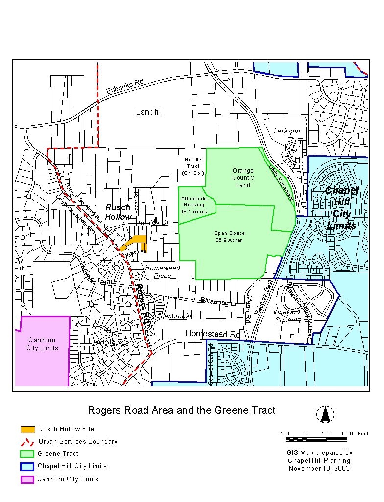
6) Request for Additional Maps: During the Public Hearing Council members requested that the staff provide the following maps: a) Copy of the Chapel Hill Zoning and Land Use Maps used during the staff’s introductory presentation; b) Copy of a Carrboro Zoning and Land Use Maps along Rogers Road; c) A regional area map that includes Homestead Road; and d) Map of the Greene Tract including the 18 acres proposed for affordable housing.
Comment: Please refer to Attachments 1, 2, and 3 of this memorandum for copies of the requested maps.
RECOMMENDATIONS
Recommendations are summarized below. Please see summaries of board actions and recommendations in the attachments.
Planning Board Recommendation: On August 5, 2003, the Planning Board voted 8-0 to recommend that the Council approved this application, including three new stipulations and the modification of a fourth stipulation, with the adoption of Resolution B.
Resolution A, the Town Manager’s Recommendation, includes all four recommendations of the Planning Board. Please see the Summary of Planning Board Action attached to the September 15, 2003 memorandum.
Transportation Board Recommendation: On August 19, 2003, the Transportation Board voted 5-0 to recommend that the Council approved this application, including one modified stipulation, with the adoption of Resolution C. Please see the attached Summary of Transportation Board Action.
Resolution C includes the recommended condition of the Transportation Board:
1. Rogers Road Improvements: That improvement along the site’s Rogers Road frontage shall include a 16 foot widening of the roadway in order to accommodate a bicycle lane.
Comment: Resolution A, the Manager’s Recommendation recommends a 14 foot widening of the roadway in order to accommodate a bicycle lane, in accordance with Council policy. For additional information, please refer to the discussion on bicycle lanes in the section above under Key Issues.
Community Design Commission Recommendation: On August 20, 2003, the Community Design Commission voted 8-2 to recommend that the Council approved this application, including three new stipulations, and modification of another stipulation, with the adoption of Resolution B.
Resolution A, the Town Manager’s Recommendation, includes all four recommendations of the Community Design Commission. Please see the Summary of Community Design Commission Action attached to the September 15, 2003 memorandum.
Parks and Recreation Commission Recommendation: On August 21, 2003, the Parks and Recreation Commission voted 9-0 to recommend that the Council approved this application, including one modified stipulation, with the adoption of Resolution D.
Resolution A, the Town Manager’s Recommendation, includes all the recommendations of the Parks and Recreation Commission. Please see the Summary of Parks and Recreation Commission Action attached to the September 15, 2003 memorandum.
Bicycle and Pedestrian Advisory Board Recommendation: On August 26, 2003, the Bicycle and Pedestrian Advisory Board voted 7-0 to recommend that the Council approved this application, including one modified stipulation, with the adoption of Resolution E.
Resolution A, the Town Manager’s Recommendation , includes the recommended condition of the Bicycle and Pedestrian Advisory Board. Please see the Summary of Bicycle and Pedestrian Advisory Board Action, attached to the September 15, 2003 memorandum.
Manager’s Revised Recommendation: Based on our evaluation of the application, our conclusion is that, with the stipulations in Resolution A, the application complies with the standards and regulations of the Land Use Management Ordinance.
If the Council makes the required findings for approval of a Special Use Permit, we recommend that the application be approved with the adoption of Resolution A. Resolution A has been revised to include a condition, and associated finding, allowing staff review and approval of the minor subdivision application necessary to create the new lots.
Resolution B would approve the application as recommended by the Planning Board and the Community Design Commission.
Resolution C would approve the application as recommended by the Transportation Board.
Resolution D would approve the application as recommended by the Parks and Recreation Commission.
Resolution E would approve the application as recommended by the Bicycle and Pedestrian Advisory Board.
Resolution F would deny the application.
Rusch Hollow - Special Use Permit
Differences Between Resolutions
|
ISSUES |
Resolution A (Approval)
Town Manager’s Revised Rec. |
Resolution B (Approval)
Planning Board, Community Design Comm. Rec. |
Resolution C (Approval)
Transportation Board Rec. |
Resolution D (Approval)
Parks & Rec. Commission Rec. |
Resolution E (Approval)
Bicycle & Ped. Advisory Brd Rec. |
|
Prohibit construction in portion of wetland area located in right-of-way |
Yes (Construction in wetlands prohibited unless approved by Council)
|
Yes (Construction in wetlands prohibited unless approved by Council)
|
* |
Yes |
* |
|
Access to lot 10 through lot 11 |
Yes |
Yes |
* |
* |
* |
|
Buffer along east property line near RCD |
Yes |
Yes |
* |
*
|
* |
|
Remove fence from recreation lot |
Yes |
Yes |
* |
* |
* |
|
Sixteen foot lane to accommodate wider bicycle lane |
No (Recommend Council policy of 14 foot lane) |
No (Recommend Council policy of 14 foot lane) |
Yes |
No (Recommend Council policy of 14 foot lane) |
No (Recommend Council policy of 14 foot lane) |
|
Recreational amenities approved by Town Manager |
Yes |
* |
*
|
Yes |
* |
|
Decrease or eliminate recreation area |
Yes (In order to preserve wetlands) |
* |
* |
Yes (In order to preserve wetlands) |
* |
|
Construct Roger Road sidewalk in right-of-way |
Yes |
* |
* |
* |
Yes |
|
Staff approval of Minor Subdivision |
Yes |
* |
* |
* |
* |
* - Issues not raised at advisory board meeting.
ATTACHMENTS
1. Chapel Hill Zoning and Land Use Maps (p. 26).
2. Carrboro Zoning Map and Land Use Maps along Rogers Road (p 28).
3. Rogers Road Area and Greene Tract Map (p. 30).
4. September 15 Memorandum and its related attachments (p. 31).
RESOLUTION A
(Manager’s Revised Recommendation)
A RESOLUTION APPROVING AN APPLICATION FOR A SPECIAL USE PERMIT FOR RUSCH HOLLOW (2003-11-10/R-8a)
BE IT RESOLVED by the Council of the Town of Chapel Hill that it finds that the Special Use Permit application proposed by Habitat for Humanity Orange County Inc. on property identified as Chapel Hill Township Tax Map 23, Block D, Lots 14, 15, and 20 (PIN’s 9870424466, 9870539615, 9870536626) if developed according to the site plan dated July 22, 2003 and conditions listed below, would:
1. That the use or development is located, designed, and proposed to be operated so as to maintain or promote the public health, safety, and general welfare;
2. That the use or development complies with all required regulations and standards of this Chapter, including all applicable provisions of Articles 3, and 5, the applicable specific standards contained in Supplemental Use Regulations (Article 6), and with all other applicable regulations;
3. That the use or development is located, designed, and proposed to be operated so as to maintain or enhance the value of contiguous property; and
4. That the use or development conforms with the general plans for the physical development of the Town as embodied in this Chapter and in the Comprehensive Plan.
BE IT FURTHER RESOLVED by the Council of the Town of Chapel Hill that it finds, in this particular case, that the following modification satisfies public purposes to an equivalent or greater degree:
1. Modification of Subsection 4.6.4 of the Land Use Management Ordinance to allow Town Manager approval, rather than Planning Board approval, of Minor Subdivision applications associated with this development.
Said public purposes being the time savings associated with a shorter review period to effect the recording of individual lots, given that the development proposal, including the subdivision of land, has been authorized with this approval by the Town Council.
BE IT FURTHER RESOLVED that this Resolution of Approval shall only be valid with the approval of a Zoning Atlas Amendment changing the zoning of the site listed above to Residential-Special Standards-Conditional, by both the Chapel Hill Town Council and the Orange County Board of Commissioners.
BE IT FURTHER RESOLVED that the Council hereby approves the application for a Special Use Permit for Rusch Hollow in accordance with the plans listed above and with the conditions listed below:
Stipulations Specific to the Development
1. That construction begin by November 10, 2005 (two years from the date of Council approval) and be completed by November 10, 2006 (three years from the date of Council approval).
2. Land Use Intensity: This Special Use Permit authorizes the creation of 14 residential lots, and land use intensity requirements and dimensional standards as specified below:
|
Land Use Intensity / Dimensional Standards |
|
|
|
|
|
No. of Residential Structures |
14 |
|
Type/Number of Dwelling Units |
Single Family Use - 12 Dwelling Units Duplex Building- 2 Dwelling Units Tri-plex Building – 3 Dwelling Units |
|
Min. Lot Size |
4,700 square feet |
|
Min. Street Frontage |
65 feet |
|
Max. Floor Area |
20,000 sq ft |
|
Min. Recreation Area |
*7,500 square feet |
|
Min. Lot Width |
65 feet |
|
Min. Street Setback |
20 |
|
Min. Interior Setback |
8 |
|
Min. Solar Setback |
8 |
|
Max. Impervious Surface |
44% |
|
Max. Floor Area |
20,000 sq ft |
* That if determined necessary by the Town Manager, the Recreation Area may be reduce in square footage in order to accommodate design revisions to the stormwater management facility and/or preserve the wetlands area.
3. Internal Streets/Sidewalks: That all internal streets be built to Town standard, constructed in a 27 foot cross section, including curb and gutter, including a 5-foot wide sidewalk and three foot utility strip on one side of the road, within a 40 foot right-of-way. The sidewalk shall be provided on at least one side of all internal streets.
4. Construction in Wetlands: Construction of public or private improvements shall be prohibited on the portions of the wetlands within the proposed right-of-way in front of lots 10 and 11. Future construction of public or private improvements within this area shall be prohibited unless authorized by Council action.
5. Access to Lot 10 and 11: Access to lot 10 shall be through a private access easement across lot 11, unless the Town Council authorizes construction across the wetland area in front of lots 10 and 11.
6. Rogers Road Improvements: That improvement along the site’s Rogers Road frontage shall include a sidewalk and widening of the north bound roadway pavement width to 14 feet in order to accommodate a bicycle lane. These improvements shall be constructed within the Rogers Road right-of-way.
7. Dedicated Right-of-Way Recordation: That all required dedicated right-of-way, including additional right-of-way necessary for improvements along Rogers Road, shall be shown on a recorded final plat, subject to approval by the Town Manager prior to the issuance of a Zoning Compliance Permit. The dedicated right-of-way shall extend to a point one-foot behind the inside edge of the proposed sidewalk.
8. Direct Access Prohibited: That direct vehicular access be prohibited from Rogers Road and Rusch Road and that the access prohibition be identified on the final plans and plat.
Stipulations Related to Affordable Housing
9. Affordable Housing: That prior to Town approval of a plat for recordation of the new lots, the applicant shall provide, for Town Manager review and approval, deed restrictions guaranteeing the affordability component of the development. The deed restrictions must, at a minimum:
a. Include 100% of the housing units in Rusch Hollow as long-term affordable housing;
b. Offer for sale twelve of the units to households earning at or below 50% of the area median income. These 12 units must remain affordable for at least ninety-nine years;
c. Deed restrictions must require that the 12 units be sold over a 99 year period only to households that earn 80% or less than the area median income;
d. Provide five rental units for households at or below 50% of area median income, ensuring that they remain affordable over a 99 year period; and
e. That these restrictions shall be recorded and cross referenced on the final plat.
10. Homeowners’ Association: That a Homeowners’ Association shall be created that has the capacity to place a lien on the property of a member who does not pay the annual charges for maintenance of common areas or easements, however designated. The Homeowners’ Association documents shall be approved by the Town Manager prior to recordation at the Orange County Register of Deeds Office and shall be cross-referenced on the final plat.
11. Dedication and Maintenance of Common Areas: That the Rogers Road landscape bufferyard area, the recreation area and stormwater facility shall be deeded to the Homeowners’ Association. The deeds shall be reviewed and approved by the Town Manager and cross referenced on the final plan. Maintenance of the common areas shall be the responsibility of the applicant or a property/homeowners association. The Homeowners’ Association documents shall include a language addressing management and continual maintenance for the common areas.
Stipulations Related to Landscaping and Architectural Issues
12. Landscape Protection Plan: That a detailed Landscape Protection Plan, clearly indicating which rare and specimen trees shall be removed and preserved and including Town standard landscaping protection notes, shall be approved by the Town Manager prior to issuance of a Zoning Compliance Permit.
13. Landscaping Plan: Bufferyard and Front Yard Tree Plan: That a detailed landscape plan including a Type “A” 20-foot wide landscape bufferyard along Rusch Road, a front yard tree planting plan, and landscape maintenance plan, be approved by the Town Manager prior to issuance of a Zoning Compliance Permit. The landscape plan shall indicate the size, type, and location of all proposed plantings.
14. Resource Conservation District Landscape Bufferyard: A minimum 6-foot wide landscape bufferyard, with trees, shall be provided on this proposed development site, between the Resource Conservation District area on the adjoining property to the east and the proposed stormwater management feature and recreation area. Existing vegetation may be used to satisfy the buffer requirement.
15. Tree Protection Fencing: That the limits of land disturbance with tree protection fencing, including off-site infrastructure construction associated with the 8-inch sewer main extension, shall be shown on the Landscape Protection Plan, to be approved by the Town Manager prior to issuance of a Zoning Compliance Permit.
Stipulations Related to Environmental Issues
16. Permanent Retention Basin Installation:
a. Compliance with the Town’s Impervious Surface Limits shall be demonstrated with the provision of a permanent stormwater retention facility in accordance with the requirements of the Land Use Management Plan and Design Manual.
b. The property owner shall post a performance bond or other surety instrument satisfactory to the Town, in an amount approved by the Town Manager, to assure maintenance, repair, or reconstruction necessary for adequate performance of the engineered stormwater controls.
c. The Owners’ or Homeowners’ Association shall be responsible for arranging for annual inspections of all facilities by an appropriately certified engineer, to determine whether the facility and associated structures are operating acceptably according to design requirements, and to report findings of said inspections to the Town Manager, with such recommendations for maintenance or repair as may be warranted. Any needed repairs shall be completed within 120 days unless otherwise approved by the Town Manager. Restrictive covenants shall be recorded which identify these responsibilities of the Owners’ or Homeowners’ Association, including maintenance.
d. Maintenance of the facility shall be the responsibility of the applicant or a property/homeowners association. A maintenance plan shall be provided, to be approved by the Town Manager. The plans shall address inspection, maintenance intervals, type of equipment required, access, and related matters.
e. As part of every application for Final Plan Approval, Zoning Compliance Permit, and residential Building Permit, the applicant shall provide an up-to-date cumulative total for impervious surfaces in the particular sub-basin.
f. All sediment deposited in the ponds during construction activity on contributing sites must be removed before “normal” pond operation begins.
17. Steep Slopes: That each submittal for Final Plan approval shall include a plan showing lots and street segments on slopes of 10% or more, and indicating how the development and construction will comply with the steep slopes regulations in the Land Use Management Ordinance:
a. For slopes of 10 - 15%, site preparation techniques shall be used which minimize grading and site disturbance;
b. for slopes of 15 - 25%, demonstrate specialized site design techniques and approaches for building and site preparation; and
c. for slopes of 25% or greater, provide a detailed site analysis of soil conditions, hydrology, bedrock conditions, and other engineering or environmental aspects of the site.
Each Final Plan application shall demonstrate compliance with the steep slopes regulations in the Land Use Management Ordinance. The Town Manager shall decide if the proposed building and site engineering techniques are appropriate. These restrictions shall be referenced in the Homeowners’ Association documents.
18. Stormwater Management Plan: That prior to the issuance of a Zoning Compliance Permit the applicant shall submit a Stormwater Management Plan for review and approval by the Town Manager. The plan shall be based on the 1-year, 2-year, and 25-year frequency, 24-hour duration storms, where the post-development stormwater run-off rate shall not exceed the pre-development rate and the post-development stormwater runoff volume shall not exceed the pre-development volume for the local 2-year frequency, 24-hour duration storm event. Engineered stormwater facilities shall also remove 85% total suspended solids and treat the first inch of precipitation utilizing NC Division of Water Quality design standards.
19. Storm Drainageway Easement: That all stormwater management improvements, outside public right-of-way, shall be located inside reserved storm drainageway easements, per Town guidelines, to be approved by the Town Manager prior to the issuance of a Zoning Compliance Permit.
20. Stormwater Operations and Maintenance Plan: That the applicant shall provide a Stormwater Operations and Maintenance Plan for all engineered stormwater facilities. We recommend that the plan include the owner's financial responsibility and include the maintenance schedule of the facilities to ensure that it continues to function as originally intended and shall be approved by the Town Manager, prior to the issuance of a Zoning Compliance Permit.
21. Wetlands Location: That the applicant submits Final Plans which show the location of State or federally regulated wetlands on the site. That any proposed disturbance of wetlands shall demonstrate compliance with applicable State and federal regulations.
22. State or Federal Approvals: That any required State or federal permits or encroachment agreements for development in the wetlands must be approved by the appropriate agencies and copies of the approved permits be submitted to the Town Manager prior to the issuance of a Zoning Compliance Permit.
23. Erosion Control: That a detailed soil erosion and sedimentation control plan, including provision for maintenance of facilities and modifications of the plan if necessary, be approved by the Orange County Erosion Control Officer and the Town Manager prior to issuance of a Zoning Compliance Permit. That a performance guarantee be provided in accordance with Section 5-97.1 of the Town Code of Ordinances prior to issuance of any permit to begin land-disturbing activity.
24. Silt Control: That the applicant takes appropriate measures to prevent and remove the deposit of wet or dry silt on adjacent paved roadways.
Stipulations Related to Utility and Service Issues
25. Off-Site Sewer Construction: That approval of this Special Use Permit shall authorize the installation of the off-site sewer infrastructure.
26. Off-Site Sewer Easement: That off-site utility easements, authorizing the installation of the 8-inch sewer line shall be provided and approved by the Town Manager and OWASA and recorded at the Orange County Register of Deeds Office prior to the issuance of a Zoning Compliance Permit.
27. Resource Conservation District Boundaries: That the boundaries of any Resource Conservation District, including that associated with the off-site sewer improvements, shall be indicated on the final plans and final plat.
28. OWASA Easements: That easement documents as required by OWASA, and the Town Manager, be recorded concurrently with the final plat. That the final plat shall be approved by OWASA prior to Town Manager approval.
29. Utility/Lighting Plan Approval: That the final Utility/Lighting Plan be approved by Duke Power Company, Orange Water and Sewer Authority, BellSouth, Public Service Company, Time Warner Cable, and the Town Manager prior to issuance of a Zoning Compliance Permit.
30. Utility Line Placement: That all new utility lines shall be placed underground. The applicant shall indicate proposed off-site utility line routing and upgrades required to service the site on Final Plans, to be approved by the Town Manager prior to issuance of a Zoning Compliance Permit.
31. Solid Waste Management Plan: That a Solid Waste Management Plan, including provisions for recycling, and for managing and minimizing construction debris and removal of existing residential debris piles, shall be approved by the Town Manager prior to issuance of a Zoning Compliance Permit.
32. Fire Flow: That a fire flow report, shall be prepared and sealed by a registered professional engineer, and showing that flows meet the minimum requirements of the Town Design Manual, to be approved by the Town Manager prior to issuance of a Zoning Compliance Permit.
33. Fire Hydrant Spacing: That maximum spacing between fire hydrants shall not exceed 500 feet, subject to approval by the Town Manager prior to issuance of a Zoning Compliance Permit.
34. Recreation Area Improvements: That the 7,500 square foot recreation area may include a picnic table and picnic shelter, or other recreational amenities deemed adequate by the Town Manager.
35. Wetlands Preservation: To minimize the impact of the development on the wetlands area, the 7,500 square foot recreation area may be decreased in size or eliminated. In-lieu of a recreation area, the area may be use for stormwater management, as a portion of a residential lot, or for any other design element deemed appropriate by the Town Manager as a means to preserve the wetlands.
36. Minor Subdivision Approval: That approval of the Minor Subdivision application creating the lots authorized with this approval shall be by the Town Manager rather than the Town Planning Board.
37. Construction Management Plan: That a Construction Management Plan, indicating how construction vehicle traffic will be managed, shall be approved by the Town Manager prior to the issuance of a Zoning Compliance Permit.
38. Open Burning: That the open burning of trees, limbs, stumps and construction debris association with this development is prohibited unless it is demonstrated to the Town Manager or his designee that no reasonable alternative means are available for removal of the materials from the subject property. The Fire Marshall may establish safety standards, which must be met in order to receive a permit.
39. Detailed Plans: That final detailed site plans, grading plans, utility/lighting plans, stormwater management plans (with hydrologic calculations), and landscape plans and landscape maintenance plans be approved by the Town Manager prior to issuance of a Zoning Compliance Permit, and that such plans conform to the plans approved by this application and demonstrate compliance with all applicable conditions and the design standards of the Land Use Management Ordinance and the Design Manual.
40. As-Built Plans: That as-built plans in DXF binary format using State plane coordinates, shall be provided for street improvements and all other existing or proposed impervious surfaces prior to issuance of the first Certificate of Occupancy.
41. Certificates of Occupancy: That no Certificates of Occupancy shall be issued until all required public improvements are completed; and that a note to this effect shall be placed on the final plat.
42. That if the Town Manager approves a phasing plan, no Certificates of Occupancy shall be issued for a phase until all required public improvements for that phase are complete; no Building Permits for any phase shall be issued until all public improvements required in previous phases are completed to a point adjacent to the new phase, and that a note to this effect shall be placed on the final plat.
43. Street Names and Addresses: That the name of the development and its streets and house numbers be approved by the Town Manager prior to the issuance of a Zoning Compliance Permit.
44. Construction Sign: That the applicant shall post a construction sign that lists the property owner’s representative and telephone number, the contractor’s representative and telephone number, and a telephone number for regulatory information at the time of issuance of a Building Permit, prior to the commencement of any land disturbing activities. The construction sign may have a maximum of 16 square feet of display area and may not exceed 6 feet in height. The sign shall be non-illuminated, and shall consist of light letters on a dark background.
45. Continued Validity: That continued validity and effectiveness of this approval is expressly conditioned on the continued compliance with the plans and conditions listed above.
46. Non-severability: That if any of the above conditions is held to be invalid, approval in its entirety shall be void.
BE IT FURTHER RESOLVED by the Council of the Town of Chapel Hill that the Council hereby approves the application for the Special Use Permit application for Rusch Hollow in accordance with the plans and conditions listed above.
This the 10th day of November, 2003.
RESOLUTION B
(Planning Board and
Community Design Commission
Recommendation)
A RESOLUTION APPROVING AN APPLICATION FOR A SPECIAL USE PERMIT FOR RUSCH HOLLOW (2003-11-10/R-8b)
BE IT RESOLVED by the Council of the Town of Chapel Hill that the Special Use Permit application proposed by Habitat for Humanity Orange County Inc. on property identified as Chapel Hill Township Tax Map 23, Block D, Lots 14, 15, and 20 (PIN’s 9870424466, 9870539615, 9870536626) if developed according to the site plan dated July 22, 2003 and conditions listed below, would:
1. That the use or development is located, designed, and proposed to be operated so as to maintain or promote the public health, safety, and general welfare;
2. That the use or development complies with all required regulations and standards of this Chapter, including all applicable provisions of Articles 3, and 5, the applicable specific standards contained in Supplemental Use Regulations (Article 6), and with all other applicable regulations;
3. That the use or development is located, designed, and proposed to be operated so as to maintain or enhance the value of contiguous property; and
4. That the use or development conforms with the general plans for the physical development of the Town as embodied in this Chapter and in the Comprehensive Plan.
BE IT FURTHER RESOLVED that the Council hereby approves the application for a Special Use Permit for Rusch Hollow in accordance with the plans listed above and with the conditions listed below:
1. Resolution A: That all of the stipulations in Resolution A shall apply to the proposed development unless modified or superseded by those stipulations below.
2. Revised Stipulations: That the stipulation related to Recreation Area Improvements deletes the reference to Town Manager approval of recreational amenities. That the stipulation related to Rogers Road Improvements delete the reference to constructing the sidewalk in side the right-of-way.
3. Deleted Stipulation: That the Wetlands Preservation stipulation shall be deleted from the resolution.
BE IT FURTHER RESOLVED that the Council hereby approves the application for the Special Use Permit application for Rusch Hollow in accordance with the plans and conditions listed above.
This the 10th day of November, 2003.
RESOLUTION C
(Transportation Board Recommendation)
A RESOLUTION APPROVING AN APPLICATION FOR A SPECIAL USE PERMIT FOR RUSCH HOLLOW (2003-11-10/R-8c)
BE IT RESOLVED by the Council of the Town of Chapel Hill that it finds that the Special Use Permit application proposed by Habitat for Humanity Orange County Inc. on property identified as Chapel Hill Township Tax Map 23, Block D, Lots 14, 15, and 20 (PIN’s 9870424466, 9870539615, 9870536626) if developed according to the site plan dated July 22, 2003, and conditions listed below, would:
1. That the use or development is located, designed, and proposed to be operated so as to maintain or promote the public health, safety, and general welfare;
2. That the use or development complies with all required regulations and standards of this Chapter, including all applicable provisions of Articles 3, and 5, the applicable specific standards contained in Supplemental Use Regulations (Article 6), and with all other applicable regulations;
3. That the use or development is located, designed, and proposed to be operated so as to maintain or enhance the value of contiguous property; and
4. That the use or development conforms with the general plans for the physical development of the Town as embodied in this Chapter and in the Comprehensive Plan.
BE IT FURTHER RESOLVED that the Council hereby approves the application for a Special Use Permit for Rusch Hollow in accordance with the plans listed above and with the conditions listed below:
1. Resolution A: That all of the stipulations in Resolution A shall apply to the proposed development unless modified or superseded by those stipulations below.
2. Revised Stipulations: That the stipulation related to Rogers Road Improvements required a northbound pavement width of 16 feet and deletes the reference to constructing the sidewalk within the right-of-way. That the stipulation related to Recreation Area Improvements shall required a 6 foot high wooden privacy fence between the recreation area and the adjoining residential lot and delete the reference to Town Manager approval of recreational amenities.
3. Deleted Stipulation: That the stipulations related to Construction in the Wetlands, Access to Lots 10 and 11, Resource Conservation District Landscape Bufferyard, and Wetlands Preservation shall be deleted from the resolution.
BE IT FURTHER RESOLVED that the Council hereby approves the application for the Special Use Permit application for Rusch Hollow in accordance with the plans and conditions listed above.
This the 10th day of November, 2003.
RESOLUTION D
(Park and Recreation Commission
Recommendation)
A RESOLUTION APPROVING AN APPLICATION FOR A SPECIAL USE PERMIT FOR RUSCH HOLLOW (2003-11-10/R-8d)
BE IT RESOLVED by the Council of the Town of Chapel Hill that it finds that the Special Use Permit application proposed by Habitat for Humanity Orange County Inc. on property identified as Chapel Hill Township Tax Map 23, Block D, Lots 14, 15, and 20 (PIN’s 9870424466, 9870539615, 9870536626) if developed according to the site plan dated July 22, 2003 and conditions listed below, would:
1. That the use or development is located, designed, and proposed to be operated so as to maintain or promote the public health, safety, and general welfare;
2. That the use or development complies with all required regulations and standards of this Chapter, including all applicable provisions of Articles 3, and 5, the applicable specific standards contained in Supplemental Use Regulations (Article 6), and with all other applicable regulations;
3. That the use or development is located, designed, and proposed to be operated so as to maintain or enhance the value of contiguous property; and
4. That the use or development conforms with the general plans for the physical development of the Town as embodied in this Chapter and in the Comprehensive Plan.
BE IT FURTHER RESOLVED that the Town Council hereby approves the application for a Special Use Permit for Rusch Hollow in accordance with the plans listed above and with the conditions listed below:
1. Resolution A: That all of the stipulations in Resolution A shall apply to the proposed development unless modified or superseded by those stipulations below.
2. Revised Stipulations: That the stipulation related to Rogers Road Improvements deletes the reference to constructing the sidewalk within the right-of-way. That the stipulation related to Recreation Area Improvements shall required a 6 foot high wooden privacy fence between the recreation area and the adjoining residential lot.
3. Deleted Stipulation: That the stipulations related to, Access to Lots 10 and 11, Resource Conservation District Landscape Bufferyard, and Wetlands Preservation shall be deleted from the resolution.
BE IT further RESOLVED that the Council hereby approves the application for the Special Use Permit application for Rusch Hollow in accordance with the plans and conditions listed above.
This the 10th day of November, 2003.
RESOLUTION E
(Bicycle and Pedestrian Advisory Board
Recommendation)
A RESOLUTION APPROVING AN APPLICATION FOR A SPECIAL USE PERMIT FOR RUSCH HOLLOW (2003-11-10/R-8e)
BE IT RESOLVED by the Council of the Town of Chapel Hill that it finds that the Special Use Permit application proposed by Habitat for Humanity Orange County Inc. on property identified as Chapel Hill Township Tax Map 23, Block D, Lots 14, 15, and 20 (PIN’s 9870424466, 9870539615, 9870536626) if developed according to the site plan dated July 22, 2003 and conditions listed below, would:
1. That the use or development is located, designed, and proposed to be operated so as to maintain or promote the public health, safety, and general welfare;
2. That the use or development complies with all required regulations and standards of this Chapter, including all applicable provisions of Articles 3, and 5, the applicable specific standards contained in Supplemental Use Regulations (Article 6), and with all other applicable regulations;
3. That the use or development is located, designed, and proposed to be operated so as to maintain or enhance the value of contiguous property; and
4. That the use or development conforms with the general plans for the physical development of the Town as embodied in this Chapter and in the Comprehensive Plan.
BE IT FURTHER RESOLVED that the Town Council hereby approves the application for a Special Use Permit for Rusch Hollow in accordance with the plans listed above and with the conditions listed below:
1. Resolution A: That all of the stipulations in Resolution A shall apply to the proposed development unless modified or superseded by those stipulations below.
2. Revised Stipulations: That the stipulation related to Recreation Area Improvements shall required a 6 foot high wooden privacy fence between the recreation area and the adjoining residential lot and delete the reference to Town Manager approval of recreational amenities.
3. Deleted Stipulation: That the stipulations related to Construction in the Wetlands, Access to Lots 10 and 11, Resource Conservation District Landscape Bufferyard, and Wetlands Preservation shall be deleted from the resolution.
BE IT FURTHER RESOLVED that the Council hereby approves the application for the Special Use Permit application for Rusch Hollow in accordance with the plans and conditions listed above.
This the 10th day of November, 2003.
RESOLUTION F
(Denying the Special Use Permit Application)
A RESOLUTION DENYING AN APPLICATION FOR A SPECIAL USE PERMIT FOR RUSCH HOLLOW (2003-11-10/R-8f)
BE IT RESOLVED by the Council of the Town of Chapel Hill that it finds that the Special Use Permit application proposed by Habitat for Humanity Orange County Inc. on property identified as Chapel Hill Township Tax Map 23, Block D, Lots 14, 15, and 20 (PIN’s 9870424466, 9870539615, 9870536626) if developed according to the site plan dated July 22, 2003 and conditions listed below, would not:
1. That the use or development is located, designed, and proposed to be operated so as to maintain or promote the public health, safety, and general welfare;
2. That the use or development complies with all required regulations and standards of this Chapter, including all applicable provisions of Articles 3, and 5, the applicable specific standards contained in Supplemental Use Regulations (Article 6), and with all other applicable regulations;
3. That the use or development is located, designed, and proposed to be operated so as to maintain or enhance the value of contiguous property; and
4. That the use or development conforms with the general plans for the physical development of the Town as embodied in this Chapter and in the Comprehensive Plan.
BE IT FURTHER RESOLVED that the Council hereby denies the application for a Special Use Permit for Rusch Hollow in accordance with the plans listed above and with the conditions listed below:
(INSERT ADDITIONAL REASONS FOR DENIAL)
BE IT FURTHER RESOLVED by the Council that the Council hereby denies the application for Rusch Hollow as proposed by Habitat for Humanity Orange County Inc.
This the 10th day of November, 2003.