TO: Mayor and Town Council
FROM: W. Calvin Horton, Town Manager
SUBJECT: Proposed Rezoning of Colonial Heights and Pinebrook Estates Areas: Zoning Atlas Amendment
DATE: October 16, 2002
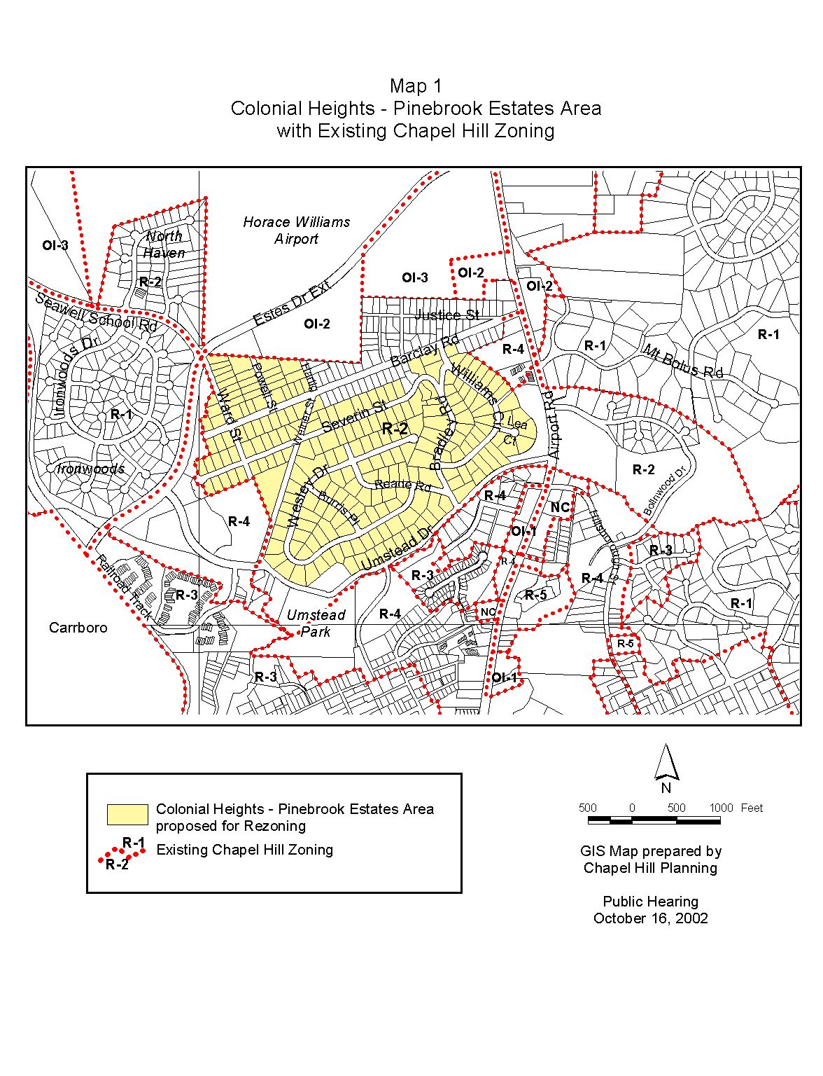
Tonight the Town Council considers the proposed rezoning of the Colonial Heights and Pinebrook Estates areas from the current Residential-2 (R-2) zoning designation to Residential-1 (R-1). An attached map shows the location and existing zoning of the proposed and surrounding areas (see Map 1).
On April 8, 2002, the Town Council called a public hearing to receive public input and consider rezoning the proposed area shown in Map 1 from Residential-2 (R-2) to Residential-1 (R-1).
On February 11, 2002, some residents of the Colonial Heights subdivision petitioned the Council concerning administrative approval of a minor subdivision in the neighborhood.
On February 25, 2002, we provided a report on the minor subdivision, and the Council adopted a resolution directing the Town Manager to study the possibilities for rezoning the Colonial Heights neighborhood to preclude future minor subdivisions in the area.
We note that one of the original points of concern that initially focused attention on larger issues for these neighborhoods was a minor subdivision that was approved for a lot on Williams Circle. In response to concerns brought to the attention of the property owner and Town staff, the property owner subsequently recorded a recombination plat, rescinding the previously approved subdivision.
On March 25, 2002, the Council received and referred to the Manager two additional petitions:
· A request from homeowners in Pinebrook Estates to consider a change in the zoning from Residential-2 to Residential-1; and to expedite a rezoning process to the maximum extent possible (see Attachment 1); and
· A request from residents and homeowners of Colonial Heights in support of rezoning Colonial Heights from Residential-2 to Residential-1; and to expedite the rezoning process (see Attachment 2).
This is a Zoning Atlas Amendment proposed by some of the property owners in the Colonial Heights and Pinebrook Estates neighborhoods. When a zoning atlas amendment is proposed, the Development Ordinance requires the Town Manager to conduct an evaluation of the proposal, to present a report to the Planning Board, and to present a report and recommendation to the Town Council. We have presented a report to the Planning Board and tonight we submit our report and preliminary recommendation to the Council.
Public Notice
Notice of this public hearing was sent to the property owner and owners of property within at least 1,000 feet of the properties proposed for rezoning (please see Attachment 3). Staff held a public information meeting on Monday, September 30, 2002. Notice was also published in the Chapel Hill Herald on Sunday October 6, 2002 and Sunday, October 13, 2002. Copies of the agenda materials on this proposal are available in the Clerk’s office and in the Public Library, and are also available on the Town’s website (www.townofchapelhill.org).
Format Tonight
The Council tonight is holding a public hearing on the proposed rezoning. The purpose of the hearing is to receive public comment on the proposed rezoning. Typically the Council refers comments made at the hearing to the Manager and Attorney for a follow-up report. We anticipate returning to the Council with this follow-up report for Council consideration on November 11, 2002.
Protest Petitions
By law, formal “Protest Petitions” may be filed against this rezoning. A formal Protest Petition meeting legal requirements would increase the votes needed to enact this rezoning. The notice mailed to property owners within 1,000 feet of the subject property included a statement that information on protest petitions was available from the Planning Department. If a protest petition is submitted and determined sufficient, a three-fourths vote by Council would be required to enact the new zoning. The deadline for filing protest petitions was 5 p.m. Friday, October 11, 2002. We will report at tonight’s Public Hearing regarding any valid protest petitions that have been submitted.
Zoning determines the type and intensity of uses and development that are allowed on a piece of land. A rezoning involves a change to the zoning of the land. In Chapel Hill, a rezoning may be requested in two ways: general use and conditional use rezoning requests. A general use rezoning request is to change the zoning to a different zoning district in which any of several kinds of developments and uses are permissible. A conditional use rezoning request is to allow development and uses only with approval of a Special Use Permit. This rezoning proposal is a general use rezoning.
The zoning designation of a property determines the range of land uses and development intensities permitted on the property. Article 20, Section 20.1 of the Development Ordinance establishes the intent of Zoning Atlas Amendments by stating:
“In order to establish and maintain sound, stable, and desirable development within the planning jurisdiction of the Town it is intended that this chapter shall not be amended except:
a) to correct a manifest error in the chapter; or
b) because of changed or changing conditions in a particular area or in the jurisdiction generally; or
c) to achieve the purposes of the Comprehensive Plan.”
Section 20.1 further indicates:
“It is further intended that, if amended, this chapter be amended only as reasonably necessary to the promotion of the public health, safety, or general welfare, and in conformance with the Comprehensive Plan.”
Proposed Rezoning of Colonial Heights Area
This rezoning proposal would change the zoning for portions of the Colonial Heights and Pinebrook Estates neighborhoods (see Map 1) from the current Residential-2 (R-2) zoning designation to Residential-1 (R-1). The Council may also consider rezoning the area to Residential 2-A (R-2-A), an intermediate zone between R-1 and R-2. As shown on the table below, R-2-A standards generally fall between the standards for R-1 and R-2.
All land in the area covered by the petitions is currently zoned Residential-2 (R-2). We have examined the area of Residential-2 zoning shown on Map 1, west of Airport Road, and north of Umstead Drive. This study area includes the Colonial Heights and Pinebrook Estates neighborhoods.
The following table illustrates the principle differences between the R-2, R-1, and R-2-A zoning districts, under the current development ordinance:
|
|
Zoning District |
||
|
Residential 2 (R-2) |
Residential 1 (R-1) |
Residential 2-A (R-2A) |
|
|
Intensity Regulations |
|||
|
Minimum lot size (square feet) |
10,000 |
17,000 |
14,500 |
|
Minimum lot width (ft) |
65 |
80 |
70 |
|
Setbacks (ft/minimum) |
|
||
|
Street |
26 |
28 |
27 |
|
Interior |
11 |
14 |
10 |
|
Solar |
13 |
17 |
12 |
|
Use Regulations |
|||
|
Single family |
Permitted |
Permitted |
Permitted |
|
Two-family, including accessory apartments |
Permitted |
Permitted |
Permitted |
|
Two-family, duplex |
Permitted |
Not permitted* |
Permitted |
* Permitted as a principal use on a lot created by a subdivision for which (a) an application for preliminary plat approval was submitted to the Town before September 5, 1983, and (b) substantial expenditures were made in good faith before December 5, 1983.
Residential-2 (R-2) zoning is a low-density zoning district, requiring 10,000 square feet of gross land area for a single-family detached house. The R-2 district requires 21,780 square feet of gross land area for a two-family dwelling (duplex or including an accessory apartment). Lots created prior to January 13, 1986 may have special status and require less land area for a two-family dwelling (15,000 square feet). Please refer to Attachment 4 for a summary of key features of the residential zoning classifications.
“Gross land area” of a lot may include calculation of one-half of the right-of-way frontage, among other factors, up to 10% of net land area.
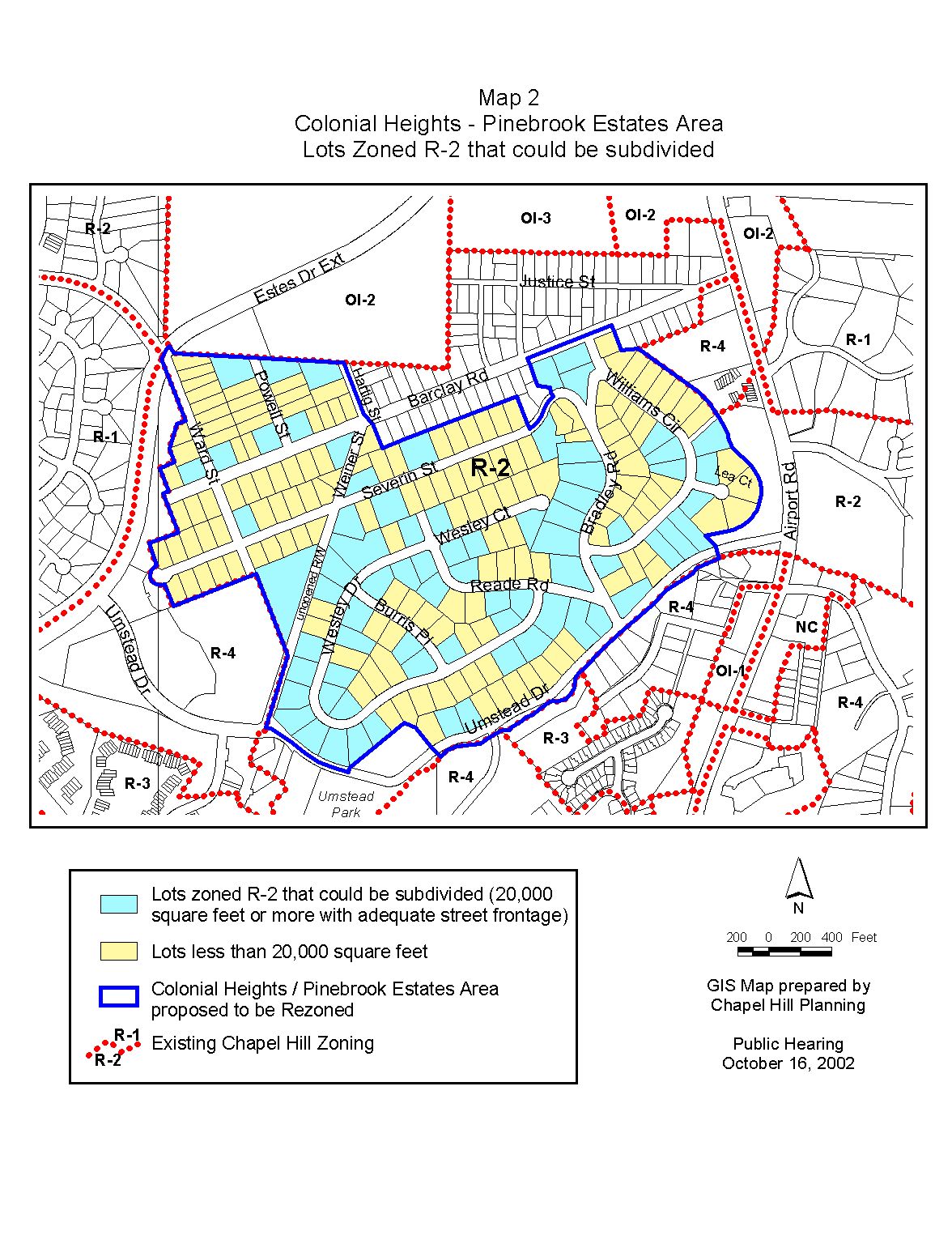
We have examined the study area and determined that a significant number of lots in the Colonial Heights/Pinebrook Estates area have a lot size that is 20,000 square feet or more and a lot width of at least 130 feet, opening the possibility of subdividing into two lots under present zoning. Please see Map 2 for an analysis.
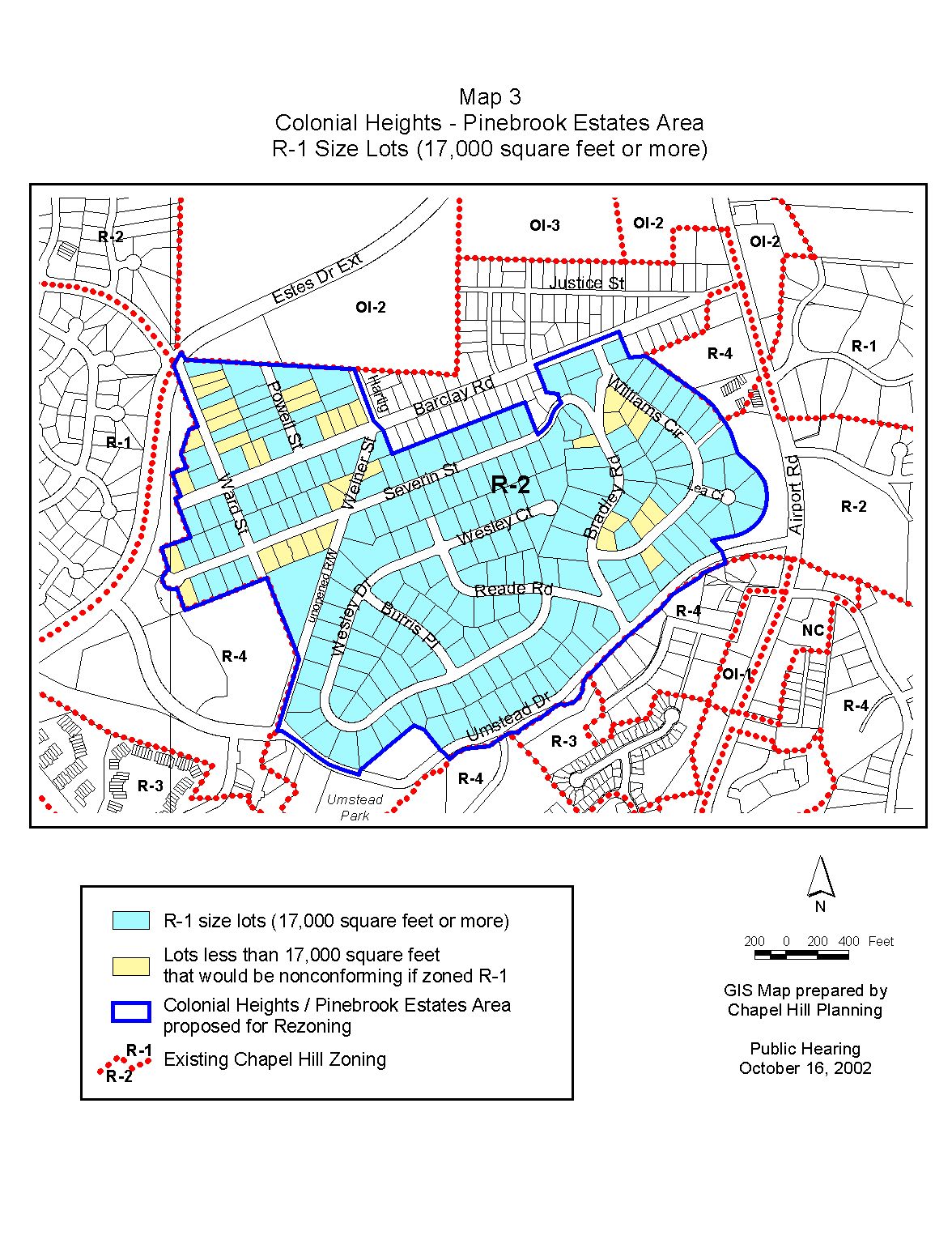
We have also mapped the lots in the study area that would conform to the minimum lot size in the requested Residential-1 (R-1) district (please see Map 3). In the R-1 district, a single family detached house requires 17,000 square feet of gross land area; a two family unit that includes an accessory apartment requires 29,040 square feet of gross land area. Lots created prior to January 13, 1986 may have special status and require less land area for a two-family unit that includes an accessory apartment (25,500 square feet). Please see Attachment 4 for an additional summary of key features of this district.
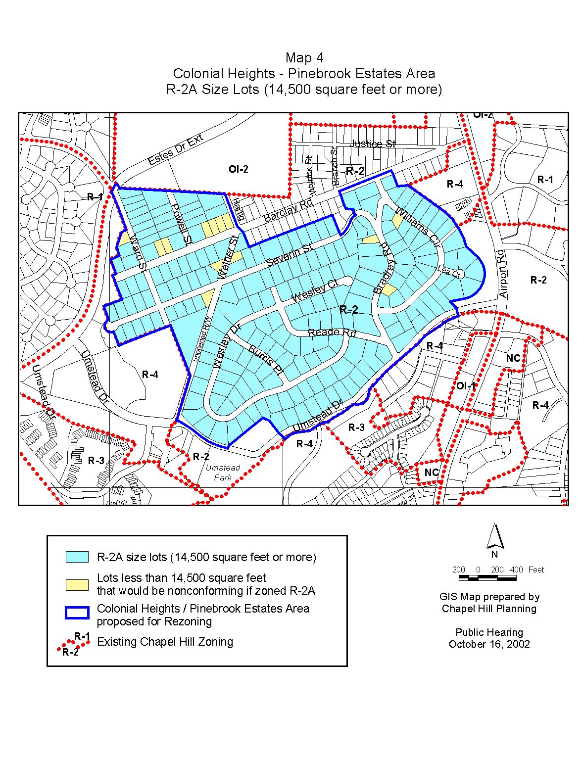
We have also examined the lots in the study area that would conform to the minimum lot size in an Residential-2A (R-2A) district (please see Map 4). In the R-2A district, a single family detached house requires 14,500 square feet of gross land area; a two family unit, whether a duplex or a two-family dwelling that includes an accessory apartment, that requires 24,891 square feet of gross land area. Please see Attachment 4 for an additional summary of key features of this district.
Comprehensive Plan
Land Use Plan
The entire area proposed for rezoning is designated as Low Residential (1-4 units/acre) on the Town of Chapel Hill Land Use Plan, adopted May 8, 2000. Residential-2, Residential-1, and Residential 2-A zoning districts are all consistent with this land use designation.
Residential Conservation Areas
The area proposed for rezoning is not designated as a “residential conservation area” on the Town’s Land Use Plan. The Land Use Plan designates certain areas surrounding the downtown and University of North Carolina campus as “residential conservation areas” because they are considered to be particularly susceptible to change. This designation means, in part, that when policy choices that affect these areas are before the Town Council, the balance should tilt in favor of protection and preservation.
The area is, however, noted as one of the “areas most susceptible to change” on Figure 1 of the Comprehensive Plan. These areas are more susceptible to change than others because of particular growth pressures or the potential availability of land for development. The Comprehensive Plan notes “close-in residential neighborhoods”, such as the area proposed for rezoning, are subject to influences such as the demand for off-campus student housing and institutional development at the edges of campus. The proposed rezoning area, in addition to being close to the downtown and main campus, is also directly south of the Horace Williams property.
Zoning Justification
As noted in the “Zoning Atlas Amendments” section of this memorandum, there are three justifications for rezonings: a) to correct a manifest error in the chapter; b) because of changed or changing conditions in a particular area or in the jurisdiction generally; or c) to achieve the purposes of the Comprehensive Plan. Only one justification needs to be met in order for the Council to approve a rezoning.
Following is a description of the evidence in the record thus far regarding the three required considerations of the Council:
A. A rezoning is necessary to correct a manifest error.
We do not believe that the current Residential-2 zoning of this site is a manifest error.
B. A rezoning is necessary because of changed or changing conditions in a particular area or in the jurisdiction generally.
We do not believe that this rezoning is necessary because of changed or changing conditions in the area or in the jurisdiction generally.
C. A rezoning is necessary to achieve the purposes of the Comprehensive Plan.
Argument in Support: As noted above, the proposed rezoning area is noted as one of the “areas most susceptible to change” in the Comprehensive Plan. Because of its proximity to the downtown and the main campus, as well as being located adjacent to the Horace Williams property, it is reasonable to believe that the Colonial Heights area will be affected by University growth and the eventual development of the Horace Williams property for University-related uses.
We believe rezoning the Colonial Heights area is consistent with the following Comprehensive Plan policies:
Ø “Conserve and enhance those elements that define Chapel Hill’s special community character and the heritage of Chapel Hill’s historic neighborhoods” (Goal, Section 3.2).
Ø “Protect the physical and social fabric of Chapel Hill’s neighborhoods” (Objective, Section 3.2).
Ø “Support preservation of existing housing stock” (Strategy 7B-1).
As noted above, the area is one of the “areas most susceptible to change” on Figure 1 of the Comprehensive Plan. Further, the Colonial Heights area consists largely of smaller and less-expensive homes than other areas of Chapel Hill. We believe that these homes are worth preserving as single-family dwellings in order to promote variety – in housing type and cost – in Chapel Hill’s housing stock. As noted above, the proposed rezoning is also consistent with the proposed area’s designation of Low Residential (1-4 units/acre) on the Town’s Land Use Plan.
Arguments in Opposition: Section 7.2 of the Comprehensive Plan contains an objective to “establish policies, regulations, incentives and programs to promote the availability of a full range of housing types, densities, costs, and tenancy options in Chapel Hill, both within new developments and existing neighborhoods.” It could be argued that by rezoning the proposed area to R-1, the potential for a variety of housing types and densities is diminished.
PENDING CHANGES TO DEVELOPMENT ORDINANCE
As part of the development ordinance revision process, the Council is considering changes to regulations related to duplexes in residential zoning districts. As noted above, currently duplexes are permitted in Residential-2 and Residential-2A districts, and permitted in the Residential-1 district only on older lots. The Third Draft of the new Land Use Management Ordinance contains provisions that would delete “duplex” as a permitted use in the Residential-1, Residential-2, and Residential-3 districts. We note that these provisions are still being considered by the Town Council, and that other provisions could be considered for the final version of the Land Use Management Ordinance.
When considering rezoning a property, or properties in this case, a consideration is the effect the rezoning may have on existing uses in the area, as well as any “nonconformities” that may result from the rezoning. Generally, the term “nonconforming” refers to lots, uses, or features that complied with regulations at the time the use or structure began, but which do not meet current regulations. Attachment 5 contains an excerpt from the development ordinance related to nonconforming lots.
In the case of the proposed rezoning of the Colonial Heights area, we have noted that several nonconforming lots would be created. Since R-1 regulations require a minimum lot size of 17,000 square feet, existing lots less than 17,000 square feet would be considered nonconforming, if the area is rezoned to R-1. Map 3 shows that 35 lots in the proposed rezoning area would become nonconforming if the neighborhood is R-1. If the Council were to rezone the area to R-2A (minimum lot size of 14,500 square feet), 13 lots would become nonconforming (see Map 4).
Planning Board Recommendation: The Planning Board is scheduled to review the proposed rezoning at its October 15, 2002 meeting. The Planning Board’s recommendation will be presented to the Council at tonight’s meeting.
Manager’s Preliminary Recommendation: We believe that the proposed rezoning is consistent with the Comprehensive Plan and the Land Use Plan, and, therefore, recommend that the Council adopt Ordinance A, approving the proposed Zoning Atlas Amendment.
1. Pinebrook Estates Petition (p. 15).
2. Colonial Heights Petition (p. 21).
3. Certification of Notice to Property Owners (p. 25).
4. Zoning Classifications – Residential Districts (p. 29).
5. Development Ordinance excerpt – Nonconforming Lots (p. 31).
MAPS
1. Existing Zoning (p. 32).
2. Lot Analysis (Subdivision Potential) (p. 33).
3. Lot Analysis (R-1 Conformity) (p. 34).
4. Lot Analysis (R-2A Conformity) (p. 35).
ORDINANCE A
(Manager’s Preliminary Recommendation)
AN ORDINANCE AMENDING THE CHAPEL HILL ZONING ATLAS FOR THE COLONIAL HEIGHTS AREA
WHEREAS, the Council of the Town of Chapel Hill has considered the petition to amend the Zoning Atlas to rezone property described below to Residential-1 zoning, and finds that the amendment is warranted due to changing conditions in the area, and in order to achieve the purposes of the Comprehensive Plan;
NOW, THEREFORE, BE IT ORDAINED by the Council of the Town of Chapel Hill that the Chapel Hill Zoning Atlas be amended as follows:
SECTION I
That the portion of the site identified as now or formerly by the following Chapel Hill Township Tax Map numbers, including intervening and abutting public right-of-way:
Chapel Hill Township, Orange County Tax Map 30, Lot 8B (portion of)
Chapel Hill Township, Orange County Tax Map 31,
Block A: All Lots within Block A; specifically Lots 1, 2, 3, 4
Block B: All Lots; specifically Lots 1, 2, 3, 4, 5, 6, 7, 8, 9, 10, 11, 12, 13, 14, 15, 16, 16A
Block C: All Lots; specifically Lots 1, 2, 3, 4, 5, 6, 7, 8, 9, 10, 11
Block D: All Lots; specifically Lots 1, 2, 3, 4, 5, 6, 7, 8, 9, 9A, 10, 11, 12, 13, 14
Block E: All Lots; specifically Lots 3, 4, 5, 6, 7, 8, 9, 10
Block F: All Lots; specifically Lots 1, 2, 3, 4, 5
Block G: All Lots; specifically Lots 1, 2, 3, 4, 5, 6
Block D: Lots 1, 2, 3, 4, 5, 6, 7, 8, 9, 10, 11, 12, 13
Chapel Hill Township, Orange County Tax Map 32,
Block D: Lots 8, 9, 10, 11, 12, 13, 14, 15, 16, 17, 18, 19
Block E: All Lots; specifically Lots 1, 2, 3, 4, 5, 6, 7, 8, 9, 10, 11, 12, 13, 14
Block F: All Lots; specifically Lots 1, 2, 3, 4, 5, 6, 7, 8, 9, 10, 10A, 11, 12, 13, 14, 15, 16
Block G: Lots 14, 15, 16, 19, 20, 21, 22, 23, 24, 25, 26, 27, 28, 28A
Chapel Hill Township, Orange County Tax Map 33,
Block A: All Lots within Block A; specifically Lots 1, 2, 3, 4, 5, 6, 7, 8, 9, 10, 11
Block B: All Lots; specifically Lots 1, 2, 3, 4, 5, 6, 7, 8, 9, 10, 11, 12
Block C: All Lots; specifically Lots 1, 2, 3, 4, 5, 6
Block D: All Lots; specifically Lots 1, 2, 3, 4, 5, 6, 7, 7A, 8, 9, 10, 11
Block F: All Lots; specifically Lots 1, 2, 2A, 3, 4, 5, 6, 7, 8, 9, 10, 11, 12, 13, 14, 15, 16, 17, 18, 19, 20
Block G: All Lots; specifically Lots 1, 2, 3, 4, 5, 6, 7, 8, 9, 10, 11, 12, 13
Block H: All Lots; specifically Lots 1, 2, 3, 4, 5, 6, 7, 8, 9, 10, 11, 12, 13, 14, 15, 16
and that are currently zoned Residential-2, shall be rezoned to Residential-1 zoning.
The description of the portions of this site to be rezoned are indicated on Map A, attached.
SECTION II
That all ordinances and portions of ordinances in conflict herewith are hereby repealed.
This the _____ day of _________, 2002.
Insert Map A
ORDINANCE B
(Rezoning to R-2-A)
AN ORDINANCE AMENDING THE CHAPEL HILL ZONING ATLAS FOR THE COLONIAL HEIGHTS AREA
WHEREAS, the Council of the Town of Chapel Hill has considered the petition to amend the Zoning Atlas to rezone property described below to Residential-2-A zoning, and finds that the amendment is warranted due to changing conditions in the area, and in order to achieve the purposes of the Comprehensive Plan;
NOW, THEREFORE, BE IT ORDAINED by the Council of the Town of Chapel Hill that the Chapel Hill Zoning Atlas be amended as follows:
SECTION I
That the portion of the site identified as now or formerly by the following Chapel Hill Township Tax Map numbers, including intervening and abutting sections of public right-of-way:
Chapel Hill Township, Orange County Tax Map 30, Lot 8B (portion of)
Chapel Hill Township, Orange County Tax Map 31,
Block A: All Lots within Block A; specifically Lots 1, 2, 3, 4
Block B: All Lots; specifically Lots 1, 2, 3, 4, 5, 6, 7, 8, 9, 10, 11, 12, 13, 14, 15, 16, 16A
Block C: All Lots; specifically Lots 1, 2, 3, 4, 5, 6, 7, 8, 9, 10, 11
Block D: All Lots; specifically Lots 1, 2, 3, 4, 5, 6, 7, 8, 9, 9A, 10, 11, 12, 13, 14
Block E: All Lots; specifically Lots 3, 4, 5, 6, 7, 8, 9, 10
Block F: All Lots; specifically Lots 1, 2, 3, 4, 5
Block G: All Lots; specifically Lots 1, 2, 3, 4, 5, 6
Block D: Lots 1, 2, 3, 4, 5, 6, 7, 8, 9, 10, 11, 12, 13
Chapel Hill Township, Orange County Tax Map 32,
Block D: Lots 8, 9, 10, 11, 12, 13, 14, 15, 16, 17, 18, 19
Block E: All Lots; specifically Lots 1, 2, 3, 4, 5, 6, 7, 8, 9, 10, 11, 12, 13, 14
Block F: All Lots; specifically Lots 1, 2, 3, 4, 5, 6, 7, 8, 9, 10, 10A, 11, 12, 13, 14, 15, 16
Block G: Lots 14, 15, 16, 19, 20, 21, 22, 23, 24, 25, 26, 27, 28, 28A
Chapel Hill Township, Orange County Tax Map 33,
Block A: All Lots within Block A; specifically Lots 1, 2, 3, 4, 5, 6, 7, 8, 9, 10, 11
Block B: All Lots; specifically Lots 1, 2, 3, 4, 5, 6, 7, 8, 9, 10, 11, 12
Block C: All Lots; specifically Lots 1, 2, 3, 4, 5, 6
Block D: All Lots; specifically Lots 1, 2, 3, 4, 5, 6, 7, 7A, 8, 9, 10, 11
Block F: All Lots; specifically Lots 1, 2, 2A, 3, 4, 5, 6, 7, 8, 9, 10, 11, 12, 13, 14, 15, 16, 17, 18, 19, 20
Block G: All Lots; specifically Lots 1, 2, 3, 4, 5, 6, 7, 8, 9, 10, 11, 12, 13
Block H: All Lots; specifically Lots 1, 2, 3, 4, 5, 6, 7, 8, 9, 10, 11, 12, 13, 14, 15, 16
and that are currently zoned Residential-2, shall be rezoned to Residential-2-A zoning.
The description of the portions of this site to be rezoned are indicated on Map B, attached.
SECTION II
That all ordinances and portions of ordinances in conflict herewith are hereby repealed.
This the _____ day of _________, 2002.
Insert Map B
(Denying R-1 Rezoning)
A RESOLUTION DENYING AN APPLICATION FOR A ZONING ATLAS AMENDMENT FOR THE COLONIAL HEIGHTS AREA
WHEREAS, the Council of the Town of Chapel Hill has considered the petition to amend the Zoning Atlas to rezone property described below to Residential-1 zoning, and fails to find that the amendment:
a) corrects a manifest error in the chapter, or
b) is justified because of changed or changing conditions in the area of the rezoning site or the community in general, or
c) achieves the purposes of the Comprehensive Plan.
For the reasons that:
(INSERT REASONS FOR DENIAL)
NOW, THEREFORE, BE IT RESOLVED by the Council of the Town of Chapel Hill that the Council hereby denies the petition to amend the Zoning Atlas for the described area to Residential-1. The description of the entire property is as indicated on Map A, attached to Ordinance A.
This the _____ day of _________, 2002.