TO: Mayor and Town Council
FROM: W. Calvin Horton, Town Manager
SUBJECT: Proposed Rezoning of Parcel at Northern Intersection of South Columbia Street and Old Pittsboro Road: Zoning Atlas Amendment
DATE: October 16, 2002
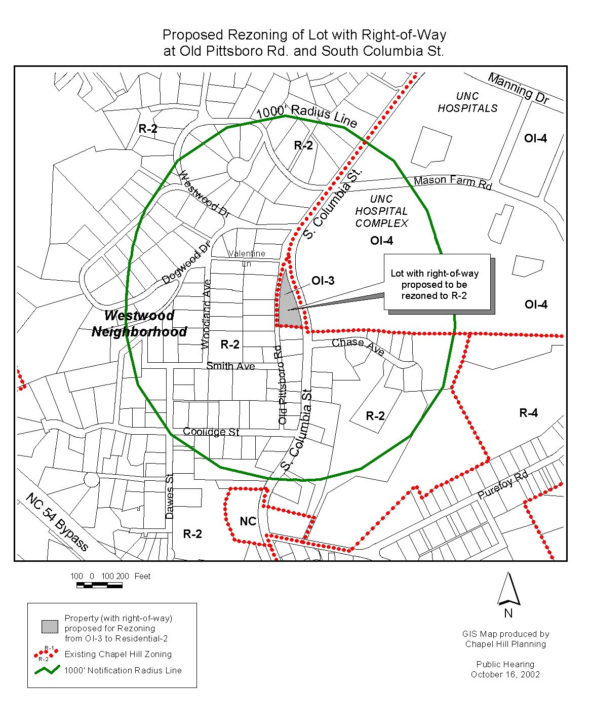
Tonight the Town Council considers the proposed rezoning of the parcel at the northern intersection of South Columbia Street and Old Pittsboro Road from its current zoning designation of Office/Institutional–3 (OI-3) to Residential-2 (R-2).
On November 26, 2001, the Town Council called a public hearing to receive public input and consider rezoning the proposed area (see Attachment 1) from Office/Institutional–3 (OI-3) to Residential-2 (R-2).
On October 22, 2001, the Council received a petition from a citizen requesting the subject parcel be rezoned (see Attachment 2).
On July 2, 2001, the Town Council adopted ordinances to create a new Office/Institutional-4 (OI-4) zoning district, and to rezone the University of North Carolina central campus area to this new zoning district. The parcel that is the subject of this current rezoning proposal was originally considered part of the central campus area that was rezoned to OI-4, but was excluded from the final rezoning action.
This is a Zoning Atlas Amendment proposed as part of a citizen petition to the Town Council. When a zoning atlas amendment is proposed, the Development Ordinance requires the Town Manager to conduct an evaluation of the proposal, to present a report to the Planning Board, and to present a report and recommendation to the Town Council. We have presented a report to the Planning Board and tonight we submit our report and preliminary recommendation to the Council.
Public Notice
Notice of this public hearing was sent to the property owner and owners of property within at least 1,000 feet of the properties proposed for rezoning (please see Attachment 3). Staff held a public information meeting on Monday, September 30, 2002. Notice was also published in the Chapel Hill Herald on Sunday October 6, 2002 and Sunday, October 13, 2002. Copies of the agenda materials on this proposal are available in the Clerk’s office and in the Public Library, and are also available on the Town’s website (www.townofchapelhill.org).
Format Tonight
The Council tonight is holding a public hearing on the proposed rezoning. The purpose of the hearing is to receive public comment on the proposed rezoning. Typically the Council refers comments made at the hearing to the Manager and Attorney for a follow-up report. We anticipate returning to the Council with a follow-up report for Council consideration on November 11, 2002.
Protest Petitions
By law, formal “Protest Petitions” may be filed against this rezoning. A formal Protest Petition meeting legal requirements would increase the votes needed to enact this rezoning. The notice mailed to property owners within 1,000 feet of the subject property included a statement that information on protest petitions was available from the Planning Department. If a protest petition is submitted and determined sufficient, a three-fourths vote by Council would be required to enact the new zoning. The deadline for filing protest petitions was 5 p.m. Friday, October 11, 2002. We will report at tonight’s Public Hearing regarding any valid protest petitions that have been submitted.
Zoning determines the type and intensity of uses and development that are allowed on a piece of land. A rezoning involves a change to the zoning of the land. In Chapel Hill, a rezoning may be requested in two ways: general use and conditional use rezoning requests. A general use rezoning request is to change the zoning to a different zoning district in which any of several kinds of developments and uses are permissible. A conditional use rezoning request is to allow development and uses only with approval of a Special Use Permit. This rezoning proposal is a general use rezoning.
The zoning designation of a property determines the range of land uses and development intensities permitted on the property. Article 20, Section 20.1 of the Development Ordinance establishes the intent of Zoning Atlas Amendments by stating:
“In order to establish and maintain sound, stable, and desirable development within the planning jurisdiction of the Town it is intended that this chapter shall not be amended except:
a) to correct a manifest error in the chapter; or
b) because of changed or changing conditions in a particular area or in the jurisdiction generally; or
c) to achieve the purposes of the Comprehensive Plan.”
Section 20.1 further indicates:
“It is further intended that, if amended, this chapter be amended only as reasonably necessary to the promotion of the public health, safety, or general welfare, and in conformance with the Comprehensive Plan.”
Proposed Rezoning
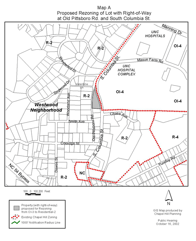
This rezoning proposal would change the zoning for the parcel at the northern intersection of South Columbia Street and Old Pittsboro Road from its current zoning designation of Office/Institutional–3 (OI-3) to Residential-2 (R-2). The lots to the west, north, and south of the lot proposed for rezoning are zoned R-2 (see map, Attachment 1). The main campus of the University, directly to the east, is zoned Office/Institutional-4 (OI-4). The lot proposed for rezoning is approximately 35,000 square feet (0.8 acres).
The lot proposed for rezoning is currently undeveloped. In 1955, with the Town’s initial zoning, the lot was zoned R-10, as was the main campus of the University. At the time, there was no zoning district specific to University uses. In the 1960s, the lot, along with the main campus, was zoned University A. The surrounding Westwood neighborhood was zoned R-15. When the Development Ordinance was revised in 1981, the lot, along with the main campus, was zoned Office/Institutional-3 (OI-3). The Westwood neighborhood was zoned R-2 at this time.
Comprehensive Plan
Land Use Plan
The parcel proposed for rezoning is designated as Low Residential (1-4 units/acre) on the Town’s Land Use Plan, adopted May 8, 2000.
Residential Conservation Areas
The parcel proposed for rezoning is part of an area designated as a “residential conservation area” on the Town’s Land Use Plan. The Land Use Plan designates certain areas surrounding the downtown and University of North Carolina campus as “residential conservation areas” because they are considered to be particularly susceptible to change. This designation means, in part, that when policy choices that affect these areas are before the Town Council, the balance should tilt in favor of protection and preservation.
Zoning Justification
As noted in the “Zoning Atlas Amendments” section of this memorandum, there are three justifications for rezonings: a) to correct a manifest error in the chapter; b) because of changed or changing conditions in a particular area or in the jurisdiction generally; or c) to achieve the purposes of the Comprehensive Plan. Only one justification needs to be met in order for the Council to approve a rezoning.
Following is a description of the evidence in the record thus far regarding the three required considerations of the Council:
A. A rezoning is necessary to correct a manifest error.
We do not believe that the current Office/Institutional-3 zoning of this site is a manifest error.
B. A rezoning is necessary because of changed or changing conditions in a particular area or in the jurisdiction generally.
We do not believe that this rezoning is necessary because of changed or changing conditions in the area or in the jurisdiction generally.
C. A rezoning is necessary to achieve the purposes of the Comprehensive Plan.
Argument in Support: The parcel proposed for rezoning is designated Low Residential (1-4 units/acre) on the Town’s Land Use Plan, adopted May 8, 2000. We believe that the proposed rezoning from the current zoning of Office/Institutional-3 to Residential-2 is consistent with the Low Residential land use designation, and more accurately reflects the intent of the Land Use Plan.
Arguments in Opposition: To date no arguments have been submitted in opposition to changing conditions in this area.
EFFECT ON EXISTING USES
The lot proposed for rezoning is currently undeveloped. The proposed rezoning is consistent with the low density residential nature of the surrounding neighborhood. We believe that no nonconformities would be created as a result of this rezoning.
NEXT STEPS
Typically the Council refers comments made at the hearing to the Manager and Attorney for a follow-up report. We anticipate returning to the Council with a follow-up report for Council consideration on November 11, 2002.
Planning Board Recommendation: The Planning Board is scheduled to review the proposed rezoning at its October 15, 2002 meeting. The Planning Board’s recommendation will be presented to the Council at tonight’s meeting.
Manager’s Preliminary Recommendation: We believe that the proposed rezoning from the current zoning of Office/Institutional-3 to Residential-2 is consistent with the Low Residential land use designation, and more accurately reflects the intent of the Land Use Plan. We recommend that the Council adopt Ordinance A, approving the proposed Zoning Atlas Amendment.
1. Map: Existing Zoning (p. 8).
2. Citizen petition (p. 9).
3. Certification of Notification to Property Owners (p. 10).
ORDINANCE A
(Manager’s Preliminary Recommendation)
AN ORDINANCE AMENDING THE CHAPEL HILL ZONING ATLAS FOR THE PARCEL AT THE NORTHERN INTERSECTION OF SOUTH COLUMBIA STREET AND OLD PITTSBORO ROAD
WHEREAS, the Council of the Town of Chapel Hill has considered the petition to amend the Zoning Atlas to rezone property described below to Residential-2 zoning, and finds that the amendment is warranted due to changing conditions in the area, and in order to achieve the purposes of the Comprehensive Plan;
NOW, THEREFORE, BE IT ORDAINED by the Council of the Town of Chapel Hill that the Chapel Hill Zoning Atlas be amended as follows:
SECTION I
That the portion of the site identified as now or formerly by Chapel Hill Township Tax Map number 7.88.H.1, and that is currently zoned Office/Institutional-3, shall be rezoned to Residential-2 zoning.
The description of the portions of this site to be rezoned are indicated on Map A, attached.
SECTION II
That all ordinances and portions of ordinances in conflict herewith are hereby repealed.
This the _____ day of _________, 2002.
(Denying R-2 Rezoning)
A RESOLUTION DENYING AN APPLICATION FOR A ZONING ATLAS AMENDMENT FOR THE PARCEL AT THE NORTHERN INTERSECTION OF SOUTH COLUMBIA STREET AND OLD PITTSBORO ROAD
WHEREAS, the Council of the Town of Chapel Hill has considered the petition to amend the Zoning Atlas to rezone property described below to Residential-2 zoning, and fails to find that the amendment:
a) corrects a manifest error in the chapter, or
b) is justified because of changed or changing conditions in the area of the rezoning site or the community in general, or
c) achieves the purposes of the Comprehensive Plan.
For the reasons that:
(INSERT REASONS FOR DENIAL)
NOW, THEREFORE, BE IT RESOLVED by the Council of the Town of Chapel Hill that the Council hereby denies the petition to amend the Zoning Atlas for the described area to Residential-2 zoning. The description of the entire property is identified as Chapel Hill Township Tax Map number 7.88.H.1.
This the _____ day of _________, 2002.