TO: Mayor and Town Council
FROM: W. Calvin Horton, Town Manager
SUBJECT: Public Hearing: Proposed Rezoning of the Mason Farm Road/Whitehead Area
DATE: March 20, 2006
PURPOSE
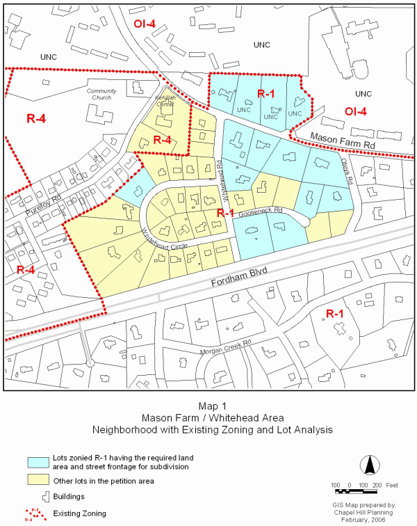
Tonight, the Council considers a proposed rezoning of the Mason Farm Road/Whitehead area from the Residential-1 zoning district to the Residential-Low Density 1 zoning district. An attached map shows the location and existing zoning of the subject area and surrounding areas (please see Map 1).
This package of material has been prepared for the Town Council’s consideration, and is organized as follows:
Cover Memorandum: Summarizes the proposed, reviews procedures for review, and offers a preliminary recommendation for Council action.
Attachments: Includes ordinances approving the rezoning (please see Attachments 1 and 2).
On October 24, 2005, representatives from the Mason Farm Neighborhood Association presented a petition to the Council requesting that it be designated as a Neighborhood Conservation District. The Neighborhood Association also requested that the following be prohibited during the period when the petition is under consideration: 1) the subdivision of lots; and 2) the construction of new units/remodeling of existing units that would create more than one dwelling unit on a single lot, including duplexes, except for accessory apartments expressly permitted by the Chapel Hill Land Use Management Ordinance.
On November 21, 2005, the Council adopted a resolution authorizing the Manager to request proposals from consultants in July 2006 to develop a Neighborhood Conservation District for the Mason Farm neighborhood. We anticipate that a Neighborhood Conservation District for this neighborhood could be in place as early as the Spring of 2007.
On January 9, 2006, we provided a report to the Council that included an analysis of the neighborhood to determine if a rezoning could address some of the concerns in the Mason Farm Road/Whitehead area. That night, the Council adopted a resolution to initiate a rezoning process for the area and scheduled tonight’s public hearing.
The Town Council has proposed a Zoning Atlas Amendment. The Land Use Management Ordinance requires the Town Manager to conduct an evaluation of the proposed rezoning, to present a report to the Planning Board, to notify property owners of the proposal, to hold a public hearing and to present a report and recommendation to the Town Council.
Public Notice
On February 9, 2006, notice of the public hearing was sent to the property owners and owners of property within 1,000 feet of the properties proposed for rezoning, and a second notice was mailed on March 3, 2006 (please see Attachment 3). Notice of the proposed rezoning was also included in the Town Week section of the Chapel Hill News on Sunday, March 5, Sunday, March 12, and Sunday, March 19. Copies of the agenda materials for the proposed rezoning are available in the Town Clerk’s office and at the Chapel Hill Public Library. Documents are also available on the Town’s website (www.townofchapelhill.org).
Format Tonight
The Council is holding a public hearing to receive citizen comment on a proposed rezoning. Typically, the Council refers comments made at the public hearing to the Manager and Town Attorney for a follow-up report. We anticipate returning to the Council with a follow up report for consideration on April 24, 2006.
Protest Petitions
By law, formal “Protest Petitions” may be filed against this rezoning. A formal Protest Petition that meets legal requirements would increase the number of votes needed to enact this rezoning. The notice mailed to property owners within 1,000 feet of the proposed boundary for rezoning included a statement that information on protest petitions was available from the Planning Department. If a protest petition is submitted and determined to be valid, a three-fourths vote by the Council would be required to enact the new zoning. The deadline for filing protest petitions with the Town Clerk was Wednesday, March 15, 2006. We will report at tonight’s Public Hearing regarding any valid protest petitions that have been submitted.
Zoning determines the type and intensity of uses and development that are allowed on a piece of land. In Chapel Hill, a rezoning may be requested in two ways: general use and conditional use rezoning requests. A general use rezoning request is to change the zoning to a different zoning district in which any of several kinds of developments and uses are permissible. A conditional use rezoning request is to allow development and uses only with approval of a Special Use Permit. The Mason Farm Road/Whitehead area rezoning proposal is a general use rezoning.
The zoning designation of a property determines the range of land uses and development intensities permitted on the property. Article 4.4 of the Land Use Management Ordinance establishes the intent of Zoning Atlas Amendments by stating:
“In order to establish and maintain sound, stable, and desirable development within the planning jurisdiction of the Town it is intended that this Chapter shall not be amended except a) to correct a manifest error in the Chapter; or b) because of changed or changing conditions in a particular area or in the jurisdiction generally; or c) to achieve the purposes of the Comprehensive Plan.
It is further intended that, if amended, this Chapter be amended only as reasonably necessary to the promotion of the public health, safety, or general welfare, and in conformance with the Comprehensive Plan.”
Proposed Rezoning Area
A total of 46 lots were identified by the Mason Farm Neighborhood Association for protection (please see the Map 1). The Council chose not to consider rezoning two properties fronting on Purefoy Road. One of these properties is developed as a place of worship and the other does not appear to be a part of the Mason Farm/Whitehead area.
On January 9, 2006, we recommended excluding the four properties north of Mason Farm Road (three owned by the University of North Carolina) from a possible rezoning. The Council scheduled tonight’s public hearing to consider an area that includes the four lots on the north side of Mason Farm Road. Three of these properties are part of the adjacent University Master Land Use Plan area and development of properties in this area as student family housing is underway. We recommend excluding these four lots from the proposed rezoning boundary.
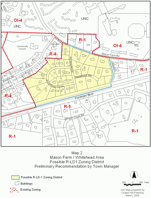
We recommend a boundary that includes 40 properties (please see Map 2).
Proposed Rezoning to Residential-Low Density 1
In response to the request by neighborhood representatives for immediate protection from subdivision of properties, the Council is considering changing the zoning in the proposed area of the Mason Farm Road/Whitehead area from the current low density Residential-1 (R-1, minimum lot size of 17,000 square feet gross land area) zoning designation to Residential-Low Density 1(R-LD1, minimum lot size of 43,560 gross land area [1 unit/acre]). “Gross land area” of a lot may include calculation of one-half of the right-of-way along the lot’s street frontage, among other factors, up to 10 percent of net land area.
We have examined a potential rezoning area, and determined that under the existing Residential-1 zoning designation, 20 of the total 44 properties have a lot size that is 34,000 square feet or more. Therefore, under the current R-1 zoning, these 20 properties could potentially be subdivided.
With the R-LD1 district, a single family house requires 43,560 square feet of gross land area. Of the total 44 lots in the proposed area, 12 meet the minimum gross land area of 43,560 square feet. There would not be any lots with enough gross land area to subdivide (minimum 87,120 square feet). Please see Map 2 for an analysis.
Rezoning the properties in the proposed area to R-LD1 would create 32 nonconforming lots. Generally, the term “nonconforming” refers to lots, uses, or features that complied with regulations at the time the use or structure began, but which do not meet current regulations. In the case of a rezoning of the Mason Farm Road/Whitehead area, nonconforming lots would be created if a property does not meet the new minimum lot size. If the neighborhood is rezoned, an existing house can be rebuilt if it is destroyed. There is nothing in the current regulations that would prevent a destroyed house from being rebuilt as it was. Additions to existing houses would have to conform to the new regulations. Some lots may currently be too small to conform to the existing regulations; adoption of a new zoning district would not change this situation.
The following table illustrates the principle differences between the R-1 and R-LD1 zoning districts, under the Land Use Management Ordinance:
|
|
Zoning District |
|
|
Residential-1 (R-1) |
Residential-Low Density 1 (R-LD1) |
|
|
Intensity Regulations |
||
|
Minimum lot size (square feet) |
17,000 |
43,560 |
|
Minimum frontage (ft) |
64 |
100 |
|
Minimum lot width (ft) |
80 |
125 |
|
Max Building Height (Primary) |
29 |
29 |
|
Max Building Height (Secondary) |
40 |
35 |
|
Setbacks (ft/minimum) |
|
|
|
Street |
28 |
30 |
|
Interior |
14 |
16 |
|
Solar |
17 |
19 |
|
Maximum Floor Area Ratio |
.076 |
0.47 |
|
Use Regulations |
||
|
Single family |
Permitted |
Permitted |
|
Single family with an accessory apartment |
Permitted (min lot size 34,000) |
Permitted (min lot size 87,120) |
|
Two-family, duplex |
Not permitted |
Not permitted |
|
Multi-family, |
Permitted * |
Permitted* |
* Requires 5 acres minimum lot size. 1 acre is equivalent to 43,560 square feet.
Please see Attachment 4 for definitions of key features of the zoning district categories.
Comprehensive Plan
Land Use Plan
The entire area proposed for rezoning is designated as Low Residential (1-4 units/acre) on the Chapel Hill Land Use Plan, adopted May 8, 2000. Residential-Low Density 1 zoning districts are consistent with this land use designation.
Residential Conservation Areas
The area proposed for rezoning is designated as a “residential conservation area” on the Town’s Land Use Plan. The Land Use Plan designates certain areas surrounding the downtown and University of North Carolina campus as “residential conservation areas” because they are considered to be particularly susceptible to change. This designation means, in part, that when policy choices that affect these areas are before the Town Council, the balance should tilt in favor of protection and preservation.
The area is also noted as one of the “areas most susceptible to change” on Figure 1 of the Comprehensive Plan. These areas are more susceptible to change than others because of particular growth pressures or the potential availability of land for development. The Comprehensive Plan notes “close-in residential neighborhoods”, such as the area proposed for rezoning, are subject to influences such as the demand for off-campus student housing and institutional development at the edges of campus.
Zoning Justification
As noted in the “Zoning Atlas Amendments” section of this memorandum, there are three justifications for rezonings: a) to correct a manifest error in the chapter; b) because of changed or changing conditions in a particular area or in the jurisdiction generally; or c) to achieve the purposes of the Comprehensive Plan. Only one justification needs to be met in order for the Council to approve a rezoning.
Following is a response to the three required considerations:
A. A rezoning is necessary to correct a manifest error.
We do not believe that the current Residential-1 zoning of this site is a manifest error.
B. A rezoning is necessary because of changed or changing conditions in a particular area or in the jurisdiction generally.
We do not believe that this rezoning is necessary because of changed or changing conditions in the area or in the jurisdiction generally. The growth of the University of North Carolina was anticipated in the Town’s Comprehensive Plan. As mentioned above, areas surrounding the University, such as the Mason Farm neighborhood, are identified as residential conservation areas.
C. A rezoning is necessary to achieve the purposes of the Comprehensive Plan.
Argument in Support: As noted above, the proposed rezoning area is designated as a “residential conservation area” and as an “area most susceptible to change” on the Town’s Land Use Plan. Because of its proximity to the downtown and the main campus, it is reasonable to believe that the physical and social fabric of the Mason Farm Road/Whitehead area will be affected by University growth, related development pressure for additional living accommodation and, the availability of land for development. The neighborhood is a cluster of modest-sized houses in a variety of styles surrounded by mature trees. The neighborhood is rich in character, which could be eroded by subdivision and incompatible infill development.
We believe rezoning the Mason Farm Road/Whitehead area is consistent with the following Comprehensive Plan policies:
“Conserve and enhance those elements that define Chapel Hill’s special community character and the heritage of Chapel Hill’s historic neighborhoods” (Goal, Section 3.2).
“Protect the physical and social fabric of Chapel Hill’s neighborhoods” (Objective, Section 3.2).
As noted above, the area is one of the “areas most susceptible to change” on Figure 1 of the Comprehensive Plan. The area is characterized by modest sized lots, and lots are dominated by woodland and tree stands. We believe that these homes and their settings have a cohesive character that is worth preserving. As noted above, the proposed rezoning is also consistent with the proposed area’s designation of Low Residential (1-4 units/acre) on the Town’s Land Use Plan.
Arguments in Opposition: Section 7.2 of the Comprehensive Plan contains an objective to “establish policies, regulations, incentives and programs to promote the availability of a full range of housing types, densities, costs, and tenancy options in Chapel Hill, both within new developments and existing neighborhoods.” It could be argued that by rezoning the proposed area to R-LD1, the potential for a variety of housing types and densities is diminished.
When considering rezoning a property or properties in this case, one factor is the effect the rezoning may have on existing uses in the area, as well as any “nonconformities” that may result from the rezoning. Generally, the term “nonconforming” refers to lots, uses, or features that complied with regulations at the time the use or structure began, but which do not meet current regulations. Attachment 5 contains an excerpt from the Land Use Management Ordinance related to nonconformities.
Nonconforming Lot:
In the case of the proposed rezoning of the Mason Farm Road/Whitehead Road area, if the Council chooses to rezone the area to the R-LD1 district (minimum lot size of 43,560 square feet), approximately 32 lots would become nonconforming (see Map 2). They would be nonconforming lots because they do not meet the minimum lot size.
For almost all circumstances, the status of a lot as a nonconforming lot poses no negative impacts for a single family residential property owner. If a nonconforming lot is vacant, the owner can still build a single family house. If a single family house already exists on a nonconforming lot, the house can be used, expanded, and rebuilt if destroyed. The impact of nonconforming lot status occurs when multiple, adjacent lots are held in common ownership and one or more is nonconforming. In keeping with State Statutes, Chapel Hill’s Land Use Management Ordinance contains the following language: “Where a nonconforming lot abuts another lot of record (whether conforming or nonconforming) held in the same ownership at or subsequent to enactment of this Chapter, such lots shall be combined or recombined as necessary to form a conforming lot or lots and shall not thereafter be subdivided except in compliance with all of the requirements of this Chapter.”
If a single family home has an accessory apartment, the minimum land area requirement would increase with a rezoning. A lot would become a nonconforming lot if it no longer had the minimum land area requirement for the two-family use. Under today’s regulations, with the R-1 zoning district, a single family dwelling with an accessory apartment would require 34,000 square feet of gross land area. If the property was rezoned to R-LD1, the minimum land area requirement for a single family dwelling with an accessory apartment would increase to 87,120 square feet of gross land area. There are no lots in the proposed boundary that would meet this minimum land area requirement.
Nonconforming Use: A nonconforming use is a land use that does not conform to the Land Use Management Ordinance regulations. All uses allowed in the R-1 zoning district are allowed in the R-LD1 zoning districts.
Nonconforming Feature: A nonconforming feature is a physical characteristic that does not conform to today’s setback, height or other intensity or design provisions of the Ordinance. A comparison of the R-1 and R-LD1 setback and height regulations is provided in the Zoning Atlas Amendments section. Nonconforming features for existing development may continue to exist and may be reconstructed if the structure was damaged or destroyed.
RECOMMENDATIONS
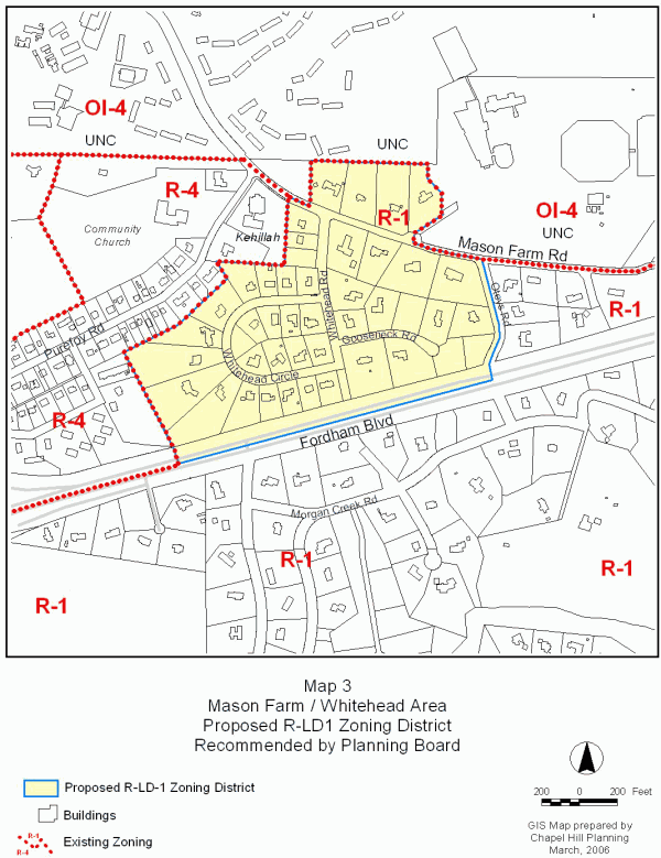
Planning Board Recommendation: On February 21, 2006, the Planning Board voted 5-2 to recommend that the Council enact the proposed Ordinance B to change the zoning designation for this neighborhood from Residential 1 (R-1) to Residential-Low Density 1 (R-LD1). Ordinance B would rezone the neighborhood to R-LD1 and would include the four lots on the north side of Mason Farm Road. Please see Attachment 6 for the Summary of Planning Board Action. Map 3 identifies the area rezoned by the Planning Board.
Ordinance B would rezone the neighborhood to R-LD1 and would include the four lots north of Mason Farm Road.
Ordinance A Approving Rezoning from Residential-1 to Residential-Low Density 1 (p. 9).
Land Use Management Ordinance excerpt – Nonconformities (p. 18).
Summary of Planning Board Action – February 21, 2006 (p. 23).
MAPS