|
TO: |
Roger L. Stancil, Town Manager |
|
FROM: |
J.B. Culpepper, Planning Director Gene Poveromo, Development Coordinator |
|
SUBJECT: |
Public Hearing: Orange County Animal Services Facility – Special Use Permit Application (File No. 9870-77-4584) |
|
DATE: |
June 18, 2007 |
Attached for your consideration is a request for a Special Use Permit to construct a public use facility for the Orange County Animal Services. The 5.96 acre site is located on the south side of Eubanks Road between the Orange County Landfill and the Norfolk Southern Railroad. The applicant has previously submitted an application for a Zoning Atlas Amendment to rezone the site from Residential-1 (R-1) to Office/Institutional-1-Conditional (OI-1-C). The site is located outside the Town of Chapel Hill’s corporate limits and in the Town’s Northern Joint Planning Transition Area (JPA).
This package of materials has been prepared for the Town Council’s consideration, and is organized as follows:
This memorandum includes an evaluation of the Special Use Permit application with the assumption that the Zoning Atlas Amendment application will be enacted.
In early 2007, the applicant submitted a Concept Plan proposal. Comments from the Community Design Commission review (February 21, 2007), including the applicant’s response are attached. Draft minutes from the Council’s March 19, 2007 review of the Concept Plan are also attached.
On March 2, 2007, the applicant submitted the Zoning Atlas Amendment application and on March 21, 2007, the applicant submitted the Special Use Permit application. On April 16 the Town Council held a Public Hearing to consider the Zoning Atlas Amendment application. Because this site is located in the Joint Planning Transition Area, a Joint Public Hearing with the Orange County Commissioners and the Town Council was held on April 26, 2007.
The Special Use Permit application proposes to construct an animal services facility (public use facility). The proposed development includes a two-story building, outdoor exercise area, service area, walking trails, and 49 parking spaces. The applicant is also proposing a bioretention facility and detention pond in the northern part of the site, for managing increased stormwater runoff associated with the proposed development. Vehicular access to the site would be provided by a new access point from Eubanks Road. The applicant is proposing to construct a left-turn lane on Eubanks Road, into the site.
The applicant is proposing to extend a water line near Millhouse Road to the frontage of this site. A well is also proposed for potable non-consumptive uses. Sanitary sewer service is proposed by extending an existing public sewer line from the east side of Millhouse Road to the north side of Eubanks Road.
The Land Use Management Ordinance requires the Town Manager to conduct an evaluation of this Special Use Permit application, to present a report to the Planning Board, and to present a report and recommendation to the Town Council. We have reviewed the application and evaluated it against Town standards; we have presented a report to the Planning Board; and tonight we submit our report and preliminary recommendation to the Council.
The standard for review and approval of a Special Use Permit application involves consideration of four findings (description of the findings follows below). Evidence will be presented tonight. If, after consideration of the evidence, the Council decides that it can make each of the four findings, the Land Use Management Ordinance directs that the Special Use Permit shall then be approved. If the Council decides that the evidence does not support making one or more of the findings, then the application cannot be approved and, accordingly, should be denied by the Council.
We have evaluated the application regarding its compliance with the standards and regulations of the Town’s Land Use Management Ordinance. Based on our evaluation, our preliminary conclusion is that, if the rezoning ordinance is adopted, the application as submitted complies with the regulations and standards of the Land Use Management Ordinance and Design Manual, with the conditions included in Resolution A.
Tonight the Council receives our attached evaluation and information submitted by the applicant and citizens. The applicant’s materials are included as attachments to this memorandum. All information that is submitted at the hearing will be included in the record of the hearing.
Based on the evidence that is submitted, the Council will consider whether or not it can make each of four required findings for the approval of a Special Use Permit.
The four findings are:
Special Use Permit – Required Findings of Fact
Following the Public Hearing, we will prepare an evaluation of the evidence submitted in support of and in opposition to this application.
We have identified several key issues concerning this application:
1. Eubanks Road improvements: The proposed project includes frontage along the south side of Eubanks Road. We recommend that the applicant improve this portion of Eubanks Road as described below:
During the review of the project, the applicant objected to the recommendation for the bike lane, curb and gutter, sidewalk and utility strip improvements along Eubanks Road. The applicant believes that these recommended improvements will not provide any near-term public benefit. The applicant also indicated that the ultimate cross-section along Eubanks Road may change in the future as the area develops. The applicant stated a preference to direct the limited project funds to energy efficiency measures rather than pavement, sidewalks and curbing.
Staff Comment: It is the Town’s practice to ensure the street frontage for all new development meets Town Standard. That standard consists of a travel lane in each direction, bike lane, curb and gutter, utility strip, and 5-foot wide sidewalk. We continue to recommend that the applicant construct these improvements along Eubanks Road. At some point in the future we anticipate there will be full width improvements, including sidewalks, along Eubanks Road. These improvements will occur as properties along Eubanks develop/re-develop or through a federal/NCDOT improvement project. In the meantime, we believe that the recommended improvements along Eubanks Road associated with this development, including the sidewalk and bike lane, are reasonable improvements associated with the proposed development. Additional discussion on the recommended Eubanks Road sidewalk follows in the next key issue.
The applicant has agreed to construct the left turn and dedicate right-of-way as recommended in Resolution A. In order to provide a left hand turn lane it will be necessary to add pavement and increase the width of Eubanks Road. We anticipate that the widening of the roadway will require an off-site construction easement from the property owner on the north side of Eubanks Road. We also anticipate that the widening project will extend westward off-site onto the landfill site to the west. Resolution A includes a stipulation requiring that the applicant provide off-site construction easements for all off-site work located on private property other than properties under the control of the applicant.
2. Eubanks Road sidewalk: The staff’s recommendation to advisory boards included a stipulation that required the applicant to construct a sidewalk along the site’s Eubanks Road frontage, including the portion of the applicant’s frontage within the railroad right-of-way. The Planning Board recommended that the development include a sidewalk along the Eubank Road frontage except for that portion of the frontage a) west of the proposed driveway; and b) within the Norfolk Southern Railroad right-of-way.
Staff Comment: We believe that sidewalk improvements along Eubanks Road are reasonable in relation to the scope of the proposed development. We recommend that the applicant construct a sidewalk along the entire Eubanks Road frontage except for that area where the sidewalk would cross the actual railroad tracks. We recommend that the construction of that portion of the sidewalk within the railroad right-of-way be subject to approval from the Norfolk Southern Railroad. If the applicant is unable to obtain approval to construct the sidewalk with the railroad right-of-way, we recommend the applicant provide a payment-in-lieu for that section of sidewalk. Resolution A includes these stipulations.
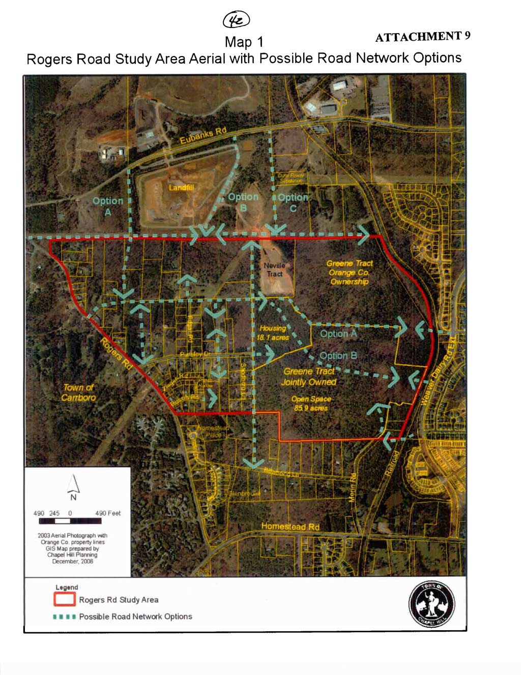
3. Access to the Greene Tract: The Town has recently formed a Task Force to study and develop a Small Area Plan for the Rogers Road area. An element of this Task Force’s work is to consider future roadway networks, with an emphasis on creating greater opportunities for access to the Rogers Road Neighborhood which includes the Greene Tract. A working draft map of some potential street corridors for this area is attached. During Concept Plan and staff reviews, the applicant was encouraged to investigate how this proposed development could incorporate a design that would accommodate a future roadway connection to the Greene Tract.
Staff Comment: We believe that any future road connection from Eubanks Road to the Rogers Road Neighborhood would ultimately be signalized. To comply with existing Town and North Carolina Department of Transportation Standards a new signalized intersection would need to be located at least 800 feet west of the existing signalized intersection at Millhouse Road. This would place such an intersection west of the subject property in the vicinity of the present landfill site. Therefore, we believe the subject property is not an appropriate location to provide an access road to serve the Rogers Road/Greene Tract neighborhood. The Task Force has requested that the Town and the County work together to identify a suitable road location(s) to serve the Rogers Road Neighborhood. We agree with the Task Force suggestion.
4. Impervious surface area: At the Planning Board meeting the applicant stated that the 74,794 square feet of impervious surface area specified with the application was an approximation of the amount of impervious surface area anticipated at final build-out. In response to a request for some flexibility, in case the final impervious surface area exceeds 74,794 square feet, the Planning Board recommended an increase to 78,000 square feet.
Staff Comment: We concur with the Planning Board. Resolution A includes a stipulation that the maximum impervious surface area be increased from 74,794 square feet to 78,000 square feet.
Subsequent to the Planning Board meeting, the applicant expressed a concern that the permitted amount of impervious surface area did not consider other existing improvements on the site. In particular, the applicant stated that the area encumbered by the proposed Special Use Permit included existing/potential ancillary impervious surface areas (railroad corridor and Genestu Drive). The applicant is concerned that these improvements would be counted towards the amount of impervious surface area available for this proposed development.
In response to the applicant’s concern, Resolution A includes a stipulation that limits that amount of impervious surface area associated with this project to 78,000 square feet. Resolution A also clarifies that existing and/or impervious surface areas associated with the railroad or Genestu Drives shall not be counted against the 78,000 square feet of permitted impervious surface area.
5. Off-site utility improvements: This proposed project requires the extension of a public sewer line. In association with this proposed development and a proposal to provide public sewer to a portion of the Orange County Landfill, we understand that a plan to extend a public sewer from the east side of Millhouse Road along the north side of Eubanks Road is in the design process.
Staff Comment: We recommend that prior to issuance of a Zoning Compliance Permit for the Orange County Animal Services Facility, that OWASA approves plans, including all required easements, and that the Town Manager approves a Zoning Compliance Permit for the extension of a public sewer line between this proposed development and the east side of Millhouse Road. We have included this as a stipulation in Resolution A.
6. On-site future utility improvements: The proposed plans identify a future 30-foot wide OWASA sewer easement, along the western boundary of the site, within the Resource Conservation District. We understand that this easement is intended to provide OWASA service to future residential development to the south. We also note that the proposed plans include a private 6-inch sewer service line between Eubanks Road and the proposed building, located east of and parallel to the proposed OWASA easement.
Staff Comment: Although we recognize the need to locate sewer infrastructure within the Resource Conservation District, we are concerned with the potential clearing and tree removal associated with the proposed 30-foot wide OWASA easement. We believe that there may be an opportunity to minimize the land disturbance associated with this public easement. During the next several weeks we intend to meet with OWASA, tonight’s applicant, and the engineer designing the sewer extension, and discuss possible options to relocate the OWASA easement away from the Resource Conservation District. We will report back to the Council when this item returns in the fall.
7. Revised Site Plans: The applicant has submitted revised site plans with the several changes. The revised plans include changes to the building footprint; service area/drive; number of parking spaces; walking trails; and accessory buildings.
Staff Comment: We believe the revised site plan reflects reasonable revisions by the applicant as the project has progressed. A copy of the most current site plan is attached to this memorandum.
As proposed, the Special Use Permit application does not comply with the land use intensity standards of the Office/Institutional-1-Conditional zoning district. The applicant is requesting modification to the following regulations:
8. Number of Parking Spaces: We understand the applicant is requesting modification to parking requirements (Section 5.9.7) of the Land Use Management Ordinance. Based on the proposed land use, a Public Use Facility, one parking space per 350 square feet of floor area, 69 spaces, is required.
Staff Comment: We recommend that the Council modify the regulations in this case. The applicant states that they need 49 spaces to meet their operational and public service objectives. The facility anticipates approximately 30 employees, plus animal control officers, volunteers, veterinarians, and general public. The site plan before the Council tonight includes 49 parking spaces. We believe the applicant’s assessment is reasonable and recommend 49 parking spaces as the maximum number of parking spaces for this site. We believe that the Council could make a finding that public purposes are satisfied to an equivalent or greater degree because of the unique nature of this application.
The Town Council has the ability to modify the regulations, according to Section 4.5.6 of the Land Use Management Ordinance. We believe that the Council could modify the proposed modifications to regulations if it makes a finding in the particular case, that public purposes are satisfied to an equivalent or greater degree. The Council may deny one or more of the proposed modifications from regulations at its discretion. If the Council chooses to deny a request for modification to regulations, the applicant’s alternatives are to comply with regulations or request a variance from regulations.
We have attached a resolution that includes standard conditions of approval as well as special conditions that we recommend for this application. With these conditions, our preliminary recommendation is that, with the requested modification to the regulations, the Council could make the four findings necessary in order to approve the application. Our recommendation, Resolution A, incorporates input from all Town departments involved in review of the application.
Planning Board: The Planning Board met on June 5, 2007 and voted 9-0 to recommend that the Council approve the Special Use Permit, with the adoption of Resolution A, as attached to the Advisory Board memorandum, with the following changes:
Staff Comment: Please refer to the Key Issues section of the memorandum for additional information.
Staff Comment: At the Planning Board meeting, a revised site plan was distributed by the applicant. This revised plan showed a reduction in the proposed parking from 55 spaces to 49 spaces. This recommendation, to reduce the number of parking spaces from 55 to 49, has been incorporated into Resolution A. Please refer to the Modification of Regulations discussion in this memorandum for additional information.
Staff Comment: Please refer to the Key Issues section of this memorandum for additional discussion on this topic.
Staff Comment: At the Planning Board meeting, the applicant noted that a portion of the required landscape bufferyard, along the east property line, was 20-feet in width and not 30-feet in width, as stated in the staff memorandum. In response the Planning Board recommended that the applicant either comply with the minimum buffer widths or obtain approval for an alternate bufferyard from the Community Design Commission.
Since the Planning Board met, we have determined that the Land Use Management Ordinance indeed requires a 30-foot Type D buffer along the railroad right-of-way and a 20-foot type C buffer adjacent to the remaining portion of the property along the eastern property line. These minimum buffer requirements have been incorporated into Resolution A. Resolution A does not recommend alternate bufferyards as an option for the buffers in this area.
Staff Comment: At the Planning Board meeting, the applicant stated that the attached resolution includes a stipulation that the existing vegetation within the landscape bufferyards remain undisturbed. Because the development proposes to include clearing and grading within the north and south bufferyards, the applicant is unable to comply with this stipulation; however the east and west bufferyards will remain generally undisturbed. Resolution A includes a stipulation that the vegetation in the east and west bufferyards shall remain generally undisturbed.
Staff Comment: At the Planning Board meeting, the applicant indicated that there may be need to install temporary erosion control features during construction in the Resource Conservation District. Resolution A includes a stipulation to this effect.
A copy of the Summary of Planning Board Action is attached to this memorandum.
Transportation Board: The Transportation Board met on June 14, 2007. We will provide the Council with a Summary of the Transportation Board Action when it is available.
Bicycle and Pedestrian Advisory Board: The Bicycle and Pedestrian Advisory Board met on June 5, 2007 and voted 7-0 to recommend that the Council approve the Special Use Permit, with the adoption of Resolution A, as attached to the Advisory Board memorandum. A copy of the Summary of Bicycle and Pedestrian Advisory Board Action is attached to this memorandum.
Community Design Commission: The Community Design Commission will meet on June 26, 2007. We will provide the Council with a Summary of the Community Design Commission Action when it is available.
Greenways Commission: The Greenways Commission will meet on June 28, 2007. We will provide the Council with a Summary of the Greenways Commission Action when it is available.
Preliminary Staff Recommendation: We recommend that the Council approve the request for a Special Use Permit with the adoption of Resolution A.
Resolution A includes the following changes from the Resolution presented to the Advisory Boards:
Following tonight’s Public Hearing, we will prepare an evaluation of the evidence submitted in support of and in opposition to this application. If the Council makes the required findings for approval of the Orange County Animal Services Facility Special Use Permit, we recommend that the application be approved with the adoption of Resolution A.
Resolution B would deny the application.
|
ISSUES |
Staff’s Preliminary |
Planning Board |
Bicycle & Pedestrian |
|
Eubanks Road sidewalk |
Entire frontage (except across the railroad tracks) |
Between west side of railroad r-o-w and east side of proposed driveway |
NA |
|
Construct sidewalk within railroad right-of-way |
Yes, or provide a payment-in-lieu |
No |
NA |
|
Maximum impervious surface |
78,000 square feet (does not include railroad or Genestu Dr) |
78,000 square feet |
NA |
|
Eastern buffer |
30-foot wide adjacent to railroad and 20-foot wide adjacent to private property |
Minimum required buffers or alternate buffer approval |
NA |
|
Undisturbed buffers |
East and west buffers |
East and west buffers |
NA |
|
Erosion control in RCD |
Yes (where necessary and with minimum land disturbance) |
Yes (where necessary and with minimum land disturbance) |
NA |