AGENDA #7c
to: Roger L. Stancil, Town Manager
from: J.B. Culpepper, Planning Director
Gene Poveromo, Development Coordinator
subject: Orange United Methodist Church Special Use Permit Modification
date: March 17, 2008
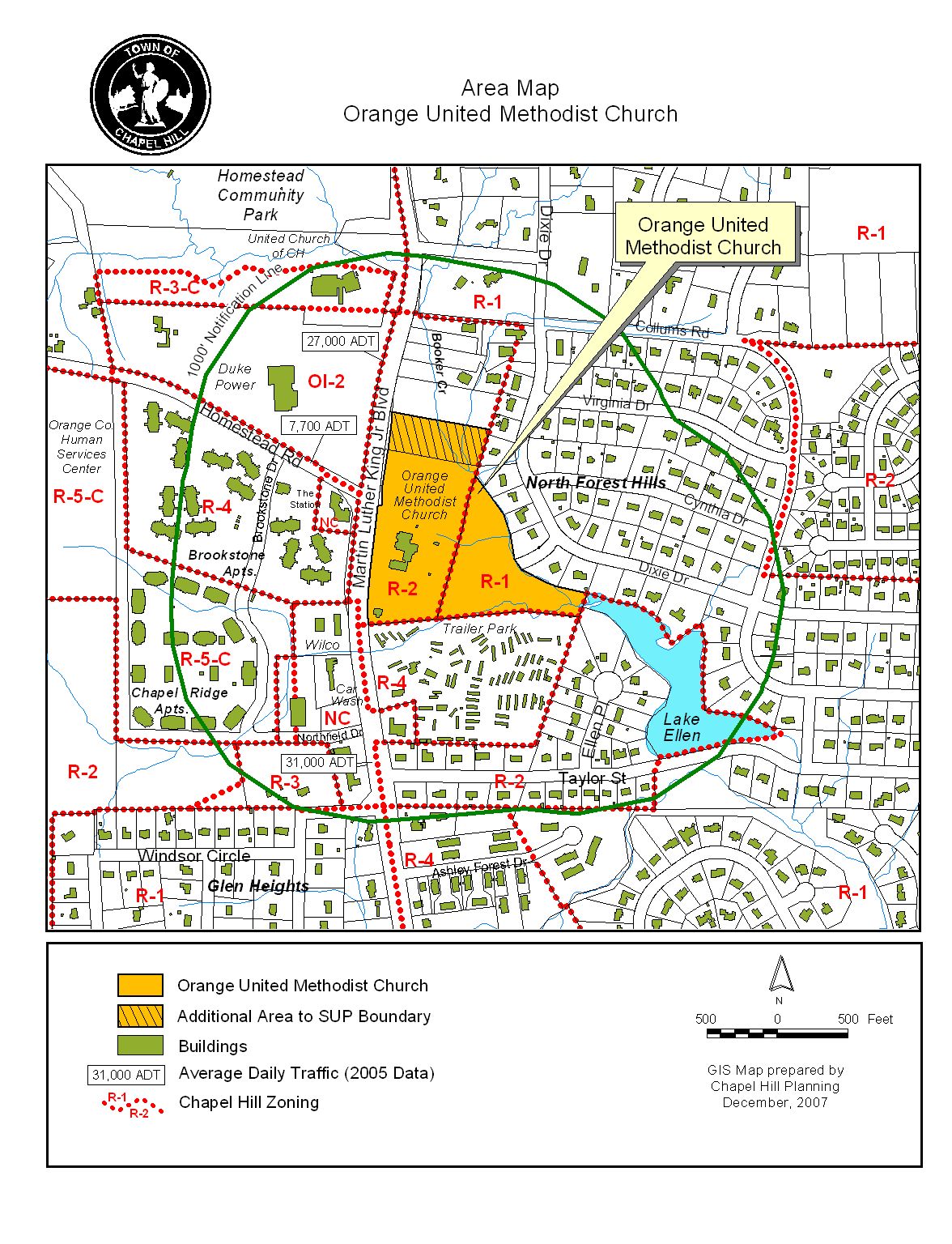
Attached for your consideration is a proposal for a Special Use Permit Modification to allow a 57,000 square-feet addition and 157 new parking spaces to the existing Orange United Methodist Church located at 1220 Martin Luther King, Jr. Blvd. Accompanying this application is an application to rezone a portion of the 16-acre site from Residential-2 (R-2) to Residential-3-C (R-3-C). The site is identified as Orange County Parcel Identifier Numbers 9880-20-9389 and 9880-30-2035.
At the public hearing, the following issues were discussed:
1. Landscape/Utility Line Conflict: In May 2007, the Council endorsed the recommendations of the NC 86/Martin Luther King, Jr. Boulevard Corridor/ Town-wide Pedestrian Safety Evaluation Study. The NC86 Corridor Study provides two potential sidewalk design options:
1) a sidewalk separated from the roadway with landscaping and street trees, or
2) landscaping and larger shade trees at the back of the sidewalk.
Although the Planning Board and Community Design Commission recommended option 1 north of the main driveway entrance, the staff did not incorporate this recommendation into Resolution A, due to concern regarding the presence of utility lines in that location. If the sidewalk were relocated behind a row of street trees, these trees would overlap the existing utility easement and would likely be heavily pruned and/or topped to reduce conflicts with these utilities.
At the public hearing, the question was raised as to whether the presence of overhead utilities was also an issue for additional plantings proposed south of the main driveway entrance.
Comment: The existing sidewalk south of the driveway is located in the right-of-way immediately adjacent to the overhead utility line and out of the buffer area (which is proposed as an alternate buffer due to the location of the parking lot), and hence there is no conflict between the sidewalk, plantings, and/or utilities.
A utility line and easement runs along the entire NC 86 frontage. South of the driveway is an existing buffer that does not comply with the minimum buffer width (resulting from overlapping parking and utility easements). The applicant is proposing an alternate 10’-wide buffer in this area. The applicant proposes to supplement this buffer with additional plantings including trees. During Final Plan review, we recommend installation of larger trees close to the edge of the parking lot to reduce future conflicts with utilities. This recommendation has been included in the Revised Resolution A.
The applicant is proposing an alternate buffer north of the driveway. North of the driveway there are no existing conflicts that prevent the applicant from providing a full width buffer, including canopy trees behind the sidewalk. Revised Resolution A stipulates that the applicant provide a 20’-wide Type “C” buffer.
2. Canopy Trees: At the public hearing, a Council member asked about the tree canopy and how long it takes a 2” caliper tree to grow to the size that would create the same shade as a 3” caliper tree. The Council member also asked about the price differential between the two different size trees.
Comment: A typical 2” caliper canopy tree, like a willow oak, will likely be the same size as a 3” caliper tree in two to three years. Once caliper size increases above about 3”, tree establishment can be more difficult so the incremental advantage of larger size is less clear. On a large project the installation cost of a typical common species at 2” caliper should be in the range of $300-$400. The staff estimates that the installation cost of the same species at 3” caliper would be approximately $200-$250 more.
We recommend a compromise between the two recommendations: for the applicant to plant 3” caliper trees for the 18 trees proposed in the Martin Luther King, Jr. Blvd. buffer and to plant 2” caliper trees on the remainder of the site. We understand that the applicant has agreed to this stipulation. Revised Resolution A includes a stipulation to this effect.
3. Specimen Tree Removal: A Council member indicated that the applicant was proposing to remove 24 trees.
Comment: Including the large number of pines and smaller hardwoods being removed behind the existing church, the estimate of total tree removal is in excess of 100. The staff would like to clarify that the 24 trees noted are the rare or specimen trees only.
4. Right-of-way on Martin Luther King, Jr. Blvd.: A Council member asked whether sufficient right-of-way exists along the Martin Luther King, Jr. Blvd. frontage to meet the recommendations of the NC 86 Corridor Study and the anticipated recommendations of the Long Range Transit Plan (particularly to allow for bus lanes). He also asked for clarification as to whether the sidewalk on the north side of the main driveway entrance is inside the NCDOT right-of-way.
Comment: We believe that sufficient right-of-way exists on the portion of Martin Luther King, Jr. Blvd along the church frontage to meet the recommendations of the NC 86 Corridor Study. Because the Long Range Transit Plan has not been approved by the Council yet, we cannot definitively say whether sufficient right-of-way exists for the alignment recommended in the Long Range Transit Plan.
Although earlier plans showed the sidewalk north of the main driveway entrance (starting approximately 180 feet north of driveway) to be on church property, the OUMC applicant has indicated that the sidewalk is actually in the NCDOT right-of-way. The plans distributed to the Council and attached to this memorandum reflect this right-of-way location. Because we are unable to verify that the entire sidewalk is located in the right-of-way, we recommend that prior to the issuance of a Zoning Compliance Permit the applicant provide documentation that the right-of-way extends to a point at least one foot behind the right-of-way.
5. Park/Ride Lot: At the public hearing, the church expressed an interest in having a park/ride facility within the proposed parking area.
Comment: We believe there may be an opportunity for this development to accommodate a limited number of park/ride spaces (between 20-50). We recommend that Resolution A include provision for a park/ride lot as an accessory use. We recommend that the park/ride lot be part of an approved Phasing Plan, and that prior to the church leasing out spaces for park/ride use, that the Town Manager review and approve the leasing agreement including the number and location of the parking spaces. Based on the information provided in the Traffic Impact Analysis, a final determination of the number of parking spaces will be made and approved by the Town Manager during Final Plan review. Revised Resolution A currently includes such a stipulation.
6. Pedestrian Crossings in Parking Lots: A Council member asked the staff to work with the applicant on a solution to the issue of access within the parking area(s).
Comment: We recommend that the applicant include a pedestrian crossing, such as stepping stones (to cross the bio-retention/planting areas) provided that the plans demonstrate that the basin is sufficiently-sized. We note that the applicant could propose a pedestrian bridge on the Final Plans, provided that they submit a design that show the bridge clearly spanning the stormwater structure and well-anchored behind the basin edges. Revised Resolution A includes stipulations to this effect.
7. Pedestrian Crossings at Main Entrance: A Council member asked about the potential to help create a clear delineation of safe passage for pedestrians across the main site entrance.
Comment: We recommend that at the Final Plan stage, the applicant provide a pedestrian crossing plan that includes means of crossing the main driveway and accessing the Worship Building from the main driveway/sidewalk area. Revised Resolution A includes a stipulation to this effect.
8. Underground Retention/Water Re-use: A Council member asked about the possibility of using water from the underground retention area for on-site irrigation.
Comment: For the planted areas, the applicant proposes to use low impact design (LID) techniques that specify plants that do not require irrigation and are planted at the right time of year.
Likewise for the playfield turf areas, the applicant proposes LID design and selection of turf seed or plugs that will not have to be irrigated. The applicant has indicated that the reuse of stormwater would require installing extra tankage and pumps, which would be cost-prohibitive, and in a drought condition might not be a reliable supply. Revised Resolution A does not include a stipulation requiring the applicant to re-use this water.
8. Erosion Control: A Council member asked about the possibility of working with NC State on Erosion Control.
Comment: The applicant has indicated an interest in working with the NC State faculty and students on implementing the latest technology in erosion control. Revised Resolution A does not include a stipulation to this effect.
PROPOSED MODIFICATIONS OF REGULATIONS
Parking Lot Landscaping: As proposed, the Special Use Permit Modification application does not comply with the parking landscaping standard (Section 5.9.6(a)) of the Land Use Management Ordinance, which requires a five-foot buffer strip between parking facilities and the exterior wall of a structure. In the rear of the proposed Worship Building, a portion of the parking lot does not meet the parking lot landscaping requirement due to a proposed small retaining wall to allow for access to the lower level of the building. The applicant proposed a landscaped courtyard between the retaining wall and the building, to provide screening.
Comment: We recommend that the Council modify the requirements of the Land Use Management Ordinance for screening between the parking and the building. For additional information, please refer to the attached request for modification from the applicant.
Council Findings and Public Purpose: The Council has the ability to modify the regulations, according to Section 4.5.6 of the Land Use Management Ordinance. We believe that the Council could modify the regulations if it makes a finding in this particular case that public purposes are satisfied to an equivalent or greater degree. If the Council chooses to deny a request for modification to regulations, the applicant’s alternatives are to comply with regulations or request a variance from regulations.
We believe that with respect to the applicant’s request to modify the regulations, the Council could make a finding that public purposes are satisfied to an equivalent or greater degree because the applicant is exceeding the parking lot screening requirement in other areas.
Planning Board: The Planning Board met on December 18, 2007 and voted 6-0 to recommend that the Council approve the Special Use Permit Modification with the adoption of the resolution attached to the Advisory Board memorandum, with the following changes:
· Revised Construction Start/Completion Date: That stipulation #1 be revised from “construction begin by two years from approval date” to “construction begin by four years from approval date” and revised from “completed 14 years from approval date” to “completed 15 years from approval date.”
Comment: This recommendation has been incorporated into Resolution A.
· Correction to Staff Error: That stipulation #2 be modified to 267 parking spaces, to correct a staff error in the Planning Board memo.
Comment: This correction has been made to Resolution A.
Community Design Commission: The Community Design Commission met on December 19, 2007 and voted 9-0 to recommend that the Council approve the Special Use Permit Modification with the adoption of the resolution attached to the Advisory Board memorandum, with the following changes:
· Martin Luther King, Jr. Blvd Landscape Buffer: That the sidewalk north of the main driveway entrance be relocated to allow trees between the sidewalk and the street.
Comment: See discussion under Discussion section.
· Revised Construction Start/Completion Date
Comment: Please see description under Planning Board Recommendation.
At the Community Design Commission meeting, a Commissioner suggested that the applicant replace the 2” caliper trees with 3” caliper trees.
Comment: Please see the Discussion section for discussion of this topic.
Transportation Board: The Transportation Board met on January 10, 2008 and voted 5-0 to recommend that the Council approve the Special Use Permit Modification with the adoption of the resolution attached to the Advisory Board memorandum, with the following changes:
· Revised Construction Start/Completion Date
Comment: Please see description under Planning Board Recommendation.
Bicycle and Pedestrian Advisory Board: The Bicycle and Pedestrian Advisory Board met on January 29, 2008 and voted 9-0 to recommend that the Council approve the Special Use Permit Modification with the adoption of the Resolution attached to the Advisory Board memorandum with the following changes:
· Additional Sidewalk Connection: That the applicant construct a sidewalk across the eastern-most parking lot planting island/bio-retention area to provide improved pedestrian circulation.
Comment: For more information, please see Discussion section.
· Martin Luther King, Jr. Blvd Landscape Buffer: That the sidewalk north of the main driveway entrance be relocated to allow trees between the sidewalk and the street.
Comment: For more information, please see Discussion section.
Staff’s Revised Recommendation: The following changes have been incorporated into Revised Resolution A:
· Revised Construction Start/Completion Date (4 years/15 years)
· Correction to Number of Parking Spaces (267 spaces)
· Type “C” 20-foot buffer north of main driveway
· Canopy Trees (3” along Martin Luther King, Jr. Blvd.)
· Park/Ride (with Phasing Plan)
· Pedestrian Crossings including bio-retention area (with Final Plans)
· Dedication of right-of-way one foot behind sidewalks
A copy of a matrix comparing the differences between the above recommendations is included at the end of this memorandum.
PROCESS
The Land Use Management Ordinance requires the Town Manager to conduct an evaluation of this Special Use Permit Modification application, to present a report to the Planning Board, and to present a report and recommendation to the Town Council. We have reviewed the application and evaluated it against Town standards; we have presented a report to the Planning Board; and tonight we submit our report and preliminary recommendation to the Council.
The standard for review and approval of a Special Use Permit Modification application involves consideration of four findings (description of the findings follows below). Evidence will be presented tonight. If, after consideration of the Evidence, the Council decides that it can make each of the four findings, and modifies the regulations as proposed by the applicant, the Land Use Management Ordinance directs that the Special Use Permit Modification shall then be approved. If the Council decides that the Evidence does not support making one or more of the findings, then the application cannot be approved and, accordingly, should be denied by the Council.
EVALUATION OF THE APPLICATION
The standard for review and approval of a Special Use Permit application involves consideration of four findings of fact that the Council must consider for granting a Special Use Permit. Based on the evidence accumulated during the Public Hearing, the Council will consider whether it can make each of the four required findings for the approval of a Special Use Permit. If, after consideration of the evidence submitted at the Public Hearing, the Council decides that it can make each of the four findings, the Land Use Management Ordinance directs that the Special Use Permit shall then be approved. If the Council decides that the evidence do not support making one or more of the findings, then the application cannot be approved and, accordingly, should be denied [Resolution B] by the Council.
Tonight, based on the evidence in the record thus far, we provide the following evaluation of this application based on the four findings of facts that the Council must consider for granting a Special Use Permit. We believe the evidence in the record to date can be summarized as follows:
Finding #1: That the use or development is located, designed, and proposed to be operated so as to maintain or promote the public health, safety, and general welfare. |
Evidence in support: Evidence in support of this finding includes the following point from the applicant’s Statement of Justification:
Evidence in opposition: We have not identified any evidence offered in opposition to Finding #1.
|
Finding #2: That the use or development complies with all required regulations and standards of the Land Use Management Ordinance, including all applicable provisions of Articles 3 and 5, the applicable specific standards in the Supplemental Use Regulations (Article 6) and with all other applicable regulations. |
Evidence in support: Evidence in support of this finding includes the following points from the applicant’s Statement of Justification:
Evidence in opposition: We have not identified any Evidence offered in opposition to Finding #2. For discussion on the applicant’s proposed modification to regulations, please refer to the Modifications to Regulations section in this memorandum.
|
Finding #3: That the use would be located, designed, and proposed to be operated so as to maintain or enhance the value of contiguous property, or that the use or development is a public necessity. |
Evidence in support: Evidence in support of this finding includes the following points from the applicant’s Statement of Justification.
· “There will be no change in the current use of the property. The proposed design to expand the church facilities has taken all aspects of the current surroundings into consideration. The character of the surrounding areas will be enhanced by the proposed improvements to the church property.” [Applicant’s Statement]
Evidence in opposition: We have not identified any Evidence offered in opposition to Finding #3.
|
Finding #4: That the use or development conforms with the general plans for the physical development of the Town as embodied in the Land Use Management Ordinance and in the Comprehensive Plan. |
Evidence in support: Evidence in support of this finding includes the following points from the applicant’s Statement of Justification.
Evidence in opposition: We have not identified any Evidence offered in opposition to Finding #4.
We anticipate that further Evidence may be presented for the Council’s consideration as part of the continued Public Hearing process. Please see the applicant’s Statement of Justification for additional Evidence in support of the four findings.
SUMMARY
We have attached a resolution that includes standard conditions of approval as well as special conditions that we recommend for this application. With these conditions, our preliminary recommendation is that, with the requested modifications to the regulations, the Council could make the four findings necessary in order to approve the application. Our recommendation, Resolution A, incorporates input from all Town departments involved in review of the application.
Orange United Methodist Church Special Use Permit Modification
DIFFERENCES AMONG RECOMMENDATIONS
|
ISSUES |
Staff’s Revised |
Planning Board |
Community Design Commission |
Transportation Board |
Bicycle/Pedestrian Advisory Board |
|
Martin Luther King, Jr. Blvd. Buffer |
No change to applicant’s plan |
* |
North of main driveway entrance - trees between sidewalk and street |
* |
Buffer as shown on NC86 Sidewalk Plan |
|
Construction Date
|
That construction begin by four years from, and completed 15 years from approval date |
That construction begin by four years from, and completed 15 years from approval date |
That construction begin by four years from, and completed 15 years from approval date
|
That construction begin by four years from, and completed 15 years from approval date
|
* |
|
Sidewalk Connection Across Bio-retention Area |
Stepping Stones |
* |
* |
* |
Construct a sidewalk across the eastern-most parking lot planting island/bio-retention area |
|
3” Caliper Trees |
3” caliper trees in front/2” trees in the rear |
* |
* |
* |
* |
|
Buffer north of main driveway |
Type “C” 20-foot buffer |
* |
* |
* |
* |
|
Park/Ride |
Yes, with Phasing Plan |
* |
* |
* |
* |
|
Pedestrian Crossings at Main Entrance |
Yes |
* |
* |
* |
* |
* = Issues not discussed, and therefore not included in the Resolution