|
to: |
Roger L. Stancil, Town Manager |
|
|
|
|
from: |
J. B. Culpepper, Planning Director |
|
|
George Small, Engineering Director |
|
|
Gene Poveromo, Development Coordinator |
|
|
|
|
subject: |
Public Hearing: Chapel Hill Bible Church Park/Ride Terminal - Application for Special Use Permit Modification |
|
|
|
|
date: |
November 13, 2006 |
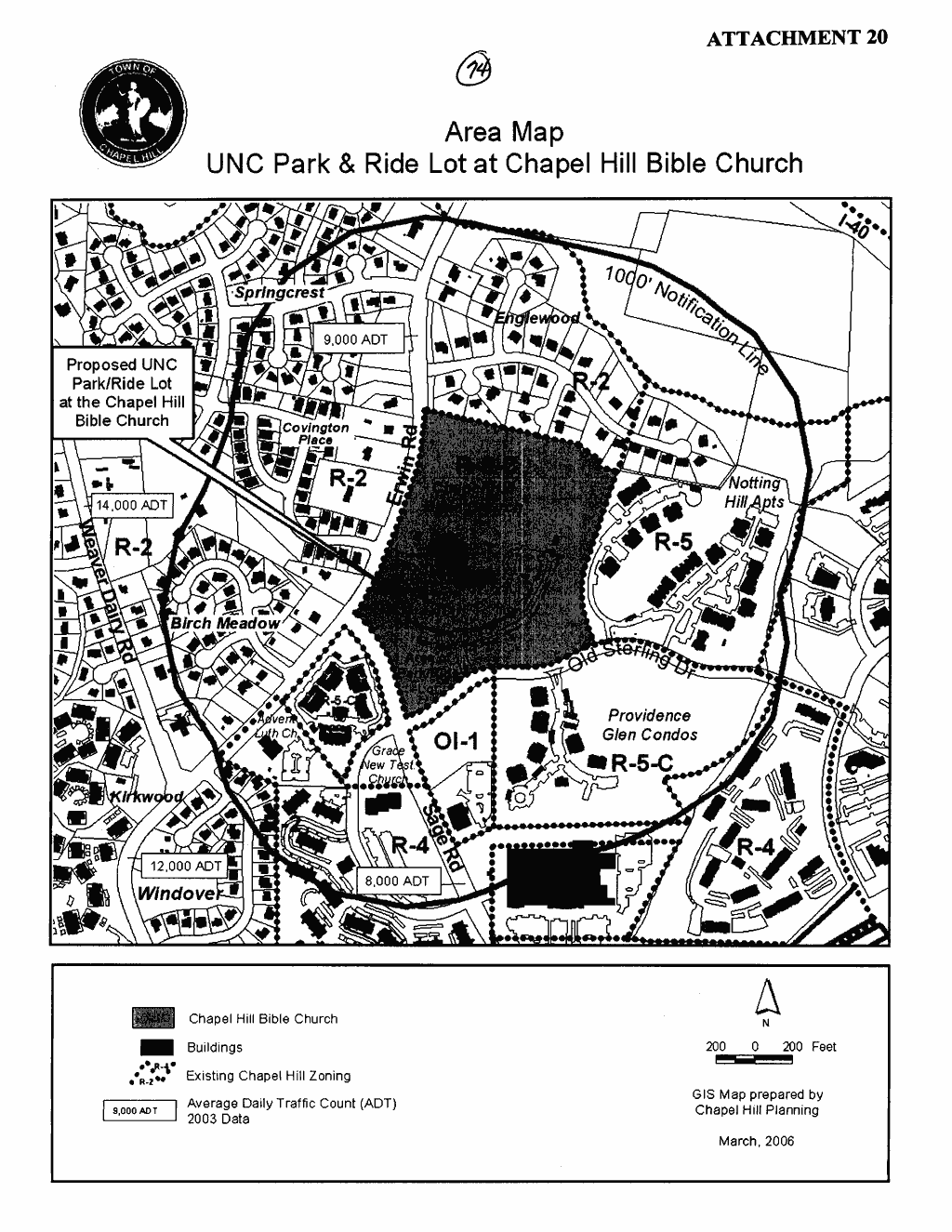
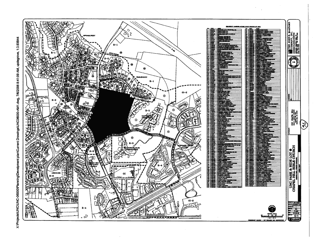
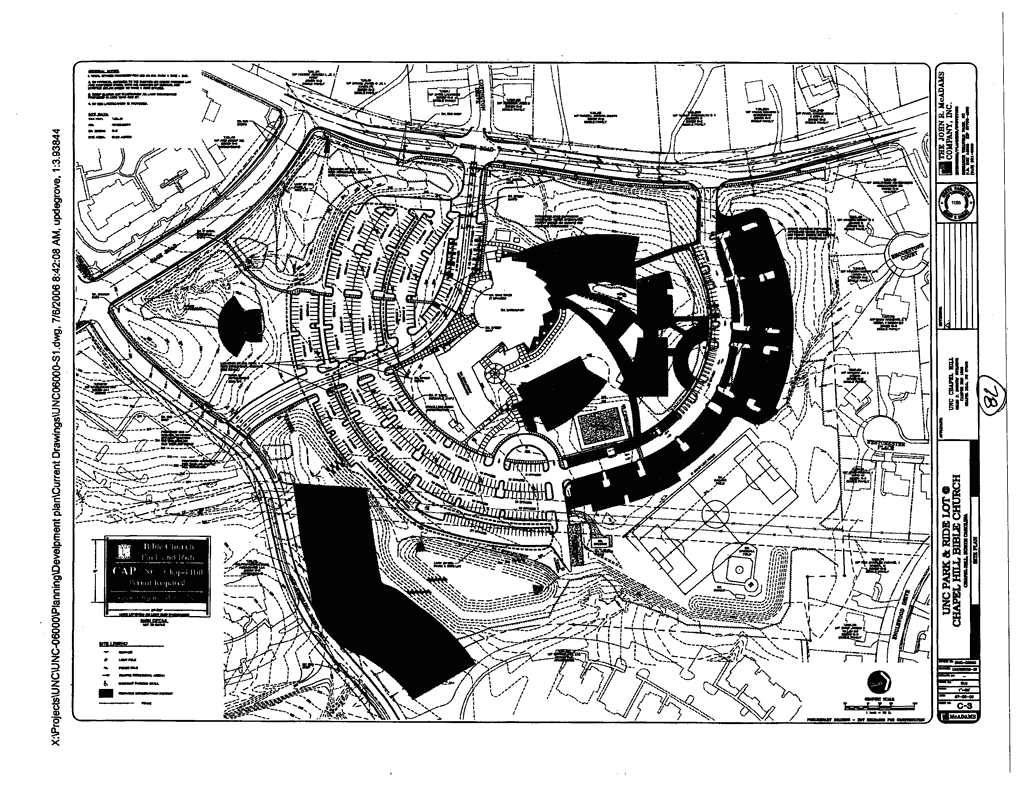
We have received a request for approval of a Special Use Permit Modification for a proposed Park/Ride Terminal at the Chapel Hill Bible Church. The 31.5-acre site is located at the northeast corner of Erwin Road and Sage Road and is identified as 260 Erwin Road. The site is located in the Residential-3-C (R-3-C) zoning district and the Resource Conservation District. A Park/Ride Terminal is allowed in a residential zoning district with the approval of a Special Use Permit. The property is identified as Orange County Parcel Identifier Number 9890-51-8534.
The applicant, the University of North Carolina at Chapel Hill, is proposing to lease 241 existing parking spaces from the Chapel Hill Bible Church for University employees. The applicant is proposing minor changes to the site, including signage, a striped crosswalk, and a new bus shelter. The applicant is proposing the new bus shelter to be located at the existing bus stop on Old Sterling Drive. If approved, this Park/Ride facility would be the fifth Park/Ride facility operated by the University.
Tonight’s Public Hearing has been scheduled to receive evidence in support of and in opposition to approval of the application, and further to receive evidence which the Council may consider as the Council determines any appropriate requirements to include as conditions of approval.
This package of materials has been prepared for the Town Council’s consideration, and is organized as follows:
The Land Use Management Ordinance requires the Manager to conduct an evaluation of this Special Use Permit Modification application, to present a report to the Planning Board, and to present a report and recommendation to the Town Council. We have reviewed the application and evaluated it against Town standards; we have presented a report to the Planning Board; and tonight we submit our report and preliminary recommendation to the Council.
The standard for review and approval of a Special Use Permit Modification application involves consideration of four findings (description of the findings follows below). Evidence will be presented tonight. If, after consideration of the evidence, the Council decides that it can make each of the four findings, the Land Use Management Ordinance directs that the Special Use Permit Modification shall then be approved. If the Council decides that the evidence does not support making one or more of the findings, then the application cannot be approved and, accordingly, should be denied by the Council.
|
October 12, 1998 |
The Town Council approved a Special Use Permit and Zoning Atlas Amendment for the Chapel Hill Bible Church. The Special Use Permit allowed construction of four buildings totaling 150,000 square feet of floor area and 500 parking spaces with additional parking spaces (303) subject to Council authorization (Attachment 12). |
|
|
|
|
March 25, 2002 |
The Town Council discussed the University of North Carolina pursuing development of a Park/Ride Terminal at the Chapel Hill Bible Church. |
|
|
|
|
May 13, 2002 |
The Town Council authorized the expansion of the Chapel Hill Bible Church parking lot to a total of 803 parking spaces (Attachment 8). |
|
|
|
|
March 27, 2006 |
The Town Council approved a request for expedited processing for a Special Use Permit Modification for the Chapel Hill Bible Church for a Park/Ride Terminal. |
|
|
|
|
March 29, 2006 |
The Community Design Commission reviewed a Concept Plan Proposal for the Chapel Hill Bible Church Park/Ride Terminal. |
|
|
|
|
April 19, 2006 |
The Town Council reviewed a Concept Plan Proposal for Chapel Hill Bible Church Park/Ride Terminal. |
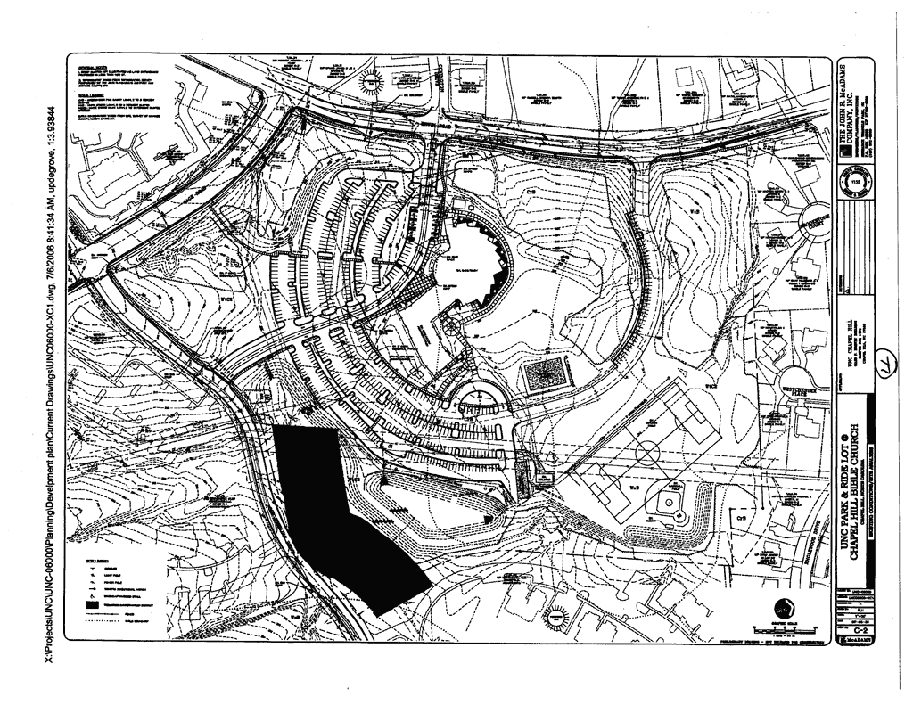
The applicant is proposing to modify the existing Special Use Permit to allow a Park/Ride Terminal as an accessory use to the place of worship. The applicant, the University of North Carolina at Chapel Hill, is proposing to lease 241 parking spaces from the Chapel Hill Bible Church for University employees. The applicant is proposing minor changes to the site, including signage, a striped crosswalk, and a new bus shelter. The applicant is proposing the new bus shelter to be located at the existing bus stop on Old Sterling Drive.
The purpose of this proposed park and ride facility is to provide alternative means of transportation for UNC employees. Employees using this location would ride an express park/ride bus from this lot to the UNC campus. No additional parking spaces will be added to the existing lot as part of this application.
The Chapel Hill Bible Church site is located in a Residential-3-C (R-3-C) zoning district. The current use of the property, a place of worship with associated on-site parking, is a permitted use. The applicant’s proposed change in use, to convert 241 of the existing parking spaces into a Park/Ride Terminal, is not a permitted use in a residential zoning district.
To establish a Park/Ride Terminal in a residential zoning district, the Land Use Management Ordinance requires:
A rezoning of the property to a non-residential zone; or
Authorization from the Council of a Special Use Permit as a Park/Ride Terminal.
In lieu of pursuing an application to rezone the property, the applicant has submitted an application for a Special Use Permit Modification for a Park/Ride Terminal.
We have evaluated the application regarding its compliance with the standards and regulations of the Town’s Land Use Management Ordinance. Based on our evaluation, our preliminary recommendation is that the application would comply with the regulations and standards of the Land Use Management Ordinance and Design Manual, with the conditions included in Resolution A.
Tonight the Council receives our attached evaluation, and also receives information submitted by the applicant and citizens. The applicant’s materials are included as attachments to this memorandum. All information that is submitted at the hearing will be placed into the record.
Based on the evidence that is submitted, the Council will consider whether or not it can make each of four required findings for the approval of a Special Use Permit Modification.
The four findings are:
Finding #1: That the use or development is located, designed, and proposed to be operated so as to maintain or promote the public health, safety, and general welfare;
Finding #2: That the use or development would comply with all required regulations and standards of the Land Use Management Ordinance;
Finding #3: That the use or development is located, designed, and proposed to be operated so as to maintain or enhance the value of contiguous property, or that the use or development is a public necessity; and
Finding #4: That the use or development conforms to the general plans for the physical development of the Town as embodied in the Land Use Management Ordinance and in the Comprehensive Plan.
Following the Public Hearing, we will prepare an evaluation of the evidence submitted in support of and in opposition to this application.
We have identified the key issues associated with this development as bus stop locations/bus shelters and lane striping on Old Sterling Drive. Each is discussed below.
Bus Stop Locations, Pull-off, and Bus Shelters: The applicant’s Special Use Permit Modification application proposed installation of a standard bus shelter at the existing bus stop on Old Sterling Drive. During Advisory Board review, the Planning Board recommended that the applicant relocates the bus stop on Old Sterling Drive to the east side of entrance drive to the Church. The Community Design Commission recommended that the bus stop on Old Sterling Drive and the bus stop on Sage Road include bus pull-off lanes. The Community Design Commission also recommended that the applicant provide larger bus shelters.
Comment: We recommend that the applicant relocate the existing bus stop to a point approximately 100 feet east of the intersection of Old Sterling Drive and the Chapel Hill Bible Church entrance drive. This new location allows park/ride users to walk from the parking lot to the bus shelter on existing sidewalks. In accordance with the Town’s Design Manual standards, we recommend that the bus stop at this location include a pull-off to provide adequate sight visibility for vehicles traveling on Old Sterling Drive and exiting from the church parking lot. If necessary, we also recommend that the Church dedicate additional public right-of-way in order to locate the bus shelter and construct the pull-off lane within the right-of-way. These recommendations have been incorporated into Resolution A.
With respect to providing a bus shelter, the Community Design Commission recommended that the applicant provide a larger than standard size bus shelter for the Old Sterling Drive bus stop. The Town generally recommends bus shelters of two different sizes and we believe the larger size bus shelter would be more appropriate for this location. We have included this recommendation in Resolution A.
Resolution A also stipulates that if the express bus route were to include the existing Sage Road bus stop, that the applicant install a large bus shelter at this location as well, within the public right-of-way.
Sage Road and Old Sterling Drive Intersection Lane Striping: The applicant is not proposing any changes to the current configuration of the intersection.
Comment: Staff is recommending that the applicant provide pavement markings on Old Sterling Drive at Sage Road to provide a left turn lane with 100 feet of storage and a combination through and right turn lane. We believe that there is adequate pavement in this area to accommodate this recommendation. We believe that the provision of the pavement markings would improve the existing level of service at the intersection. Resolution A has been revised to incorporate this stipulation.
Following is a brief outline describing the next steps in the development review process, should the Council approve the Special Use Permit Modification application for this site:
Applicant submits detailed Final Plans and documentation, complying with Council stipulations. Information is reviewed by Town departments and the following agencies (if applicable):
Advisory Board recommendations incorporated into Resolution A, the staff’s Preliminary Recommendation:
Following Advisory Boards review of the application, the following recommendations were included in Resolution A, the staff’s preliminary recommendation:
Bicycle Parking: That the development shall provide a minimum of 25 Class II bicycle parking spaces. That the bicycle parking shall be reviewed and approved by the Town Manager prior to the issuance of a Zoning Compliance Permit. This improvement shall be installed prior to use as a Park/Ride Terminal.
Comment: The Chapel Hill Bible Church currently includes six bicycle parking spaces on-site. Section 5.9.7 of the Land Use Management Ordinance requires 10 percent of the auto parking spaces for park/ride uses. With respect to the proposed 241 park/ride spaces, compliance with the Land Use Management Ordinance would require that the applicant provide a minimum of 25 bicycle parking spaces.
The Planning Board recommended that the applicant increase the number of bicycle parking spaces on-site. The Board recommended that prior to operating the site as a park/ride facility, that the applicant provide an additional 19 bicycle parking spaces. The Board also recommended the spaces comply with the Class II bicycle parking standards. We agree that additional Class II bicycle parking spaces should be provided on site. This recommendation has been incorporated in Resolution A.
Park/Ride Terminal Expiration Date: That this accessory use is approved for a time period not to exceed five years from the issuance of a Zoning Compliance Permit.
Comment: We understand that the Church and the applicant have a lease agreement that authorizes the applicant to operate the proposed park/ride facility for a period of five years. Due to the fact that the facility may be in operation for this limited time period, we recommend limiting the time frame for the proposed use to five years. This recommendation has been included in Resolution A.
Bus Stop Location on Old Sterling Drive: That the existing bus stop on Old Sterling Drive is relocated east of the Old Sterling Drive entrance drive.
Comment: Please see the Key Issues section of this memorandum for additional information regarding bus stop locations.
Bus Shelter: That proposed bus shelter on Old Sterling Drive be resized to provide a larger bus shelter than those currently existing on Old Sterling Drive and be located outside the right-of-way.
Comment: Please see the Key Issues section of this memorandum for additional information on the recommended size for the new bus shelter.
Lighting Plan: That prior to the issuance of a Zoning Compliance Permit, the applicant shall submit site plans and other required documents to satisfy the lighting requirements of Section 5.11, including the submission of a lighting plan sealed by a professional engineer.
Comment: The Community Design Commission recommended that the applicant provide a lighting plan including pedestrian lighting for the bus stops. We recommend that, as part of the Final Plan Review process, the applicant demonstrate that the existing level of lighting is adequate for pedestrian safety.
Advisory Board Recommendations not incorporated into Resolution A, the Staff’s Preliminary Recommendation
Advisory Boards recommended the following stipulations, which are not incorporated into Resolution A, the staff’s preliminary recommendation:
Electrical Extension to the Bus Shelter: That electrical extensions should be provided for the bus shelter to allow for lighting.
Comment: The Transportation Board recommended that the proposed bus shelters be provided with lighting. We believe that with the longevity of this project tied to a five-year limit, that the existing standard bus shelter is appropriate. If the project were to seek additional approval to continue the accessory use beyond the authorized five-year period, additional lighting could be incorporated into a request to modify the Special Use Permit.
Sage Road Bus Pull-off: That the Sage Road bus stop include a bus pull-off on Sage Road.
Comment: Please refer to the Key Issues section of this memorandum for additional information.
Traffic Study: That if the Council determines that an additional Traffic Study is needed, that the study include Eastowne Drive.
Comment: The Community Design Commission recommended that if additional traffic analysis is warranted, that the study should include Eastowne Drive. We believe the existing Traffic Impact Analysis adequately addresses the impact of the proposed park/ride terminal. The Analysis examined the intersections of US 15-501 and Sage Road, and Sage Road and Erwin Road.
Recommendations from Advisory Boards and Staff are summarized below:
Planning Board Recommendation: On October 3, 2006, the Planning Board voted 8-0 to recommend that the Council approve this application with the adoption of Resolution B. Please see the attached Summary of Planning Board Action.
Transportation Board Recommendation: On October 12, 2006, the Transportation Board voted 6-0 to recommend that the Council approve this application with the adoption of Resolution C. Please see the attached Summary of Transportation Board Action.
Community Design Commission Recommendation: On October 18, 2006, the Community Design Commission voted 5-2 to recommend that the Council approve this application with the adoption of Resolution D. Please see the attached Summary of Community Design Commission Action.
Bicycle and Pedestrian Advisory Board Recommendation: On October 24, 2006, the Bicycle and Pedestrian Advisory Board voted 8-0 to recommend that the Council approve this application with the adoption of Resolution E. Please see the attached Summary of Bicycle and Pedestrian Advisory Board Action.
Staff’s Preliminary Recommendation: Based on our evaluation of the application, our preliminary conclusion is that, with the stipulations in Resolution A, the application complies with the standards and regulations of the Land Use Management Ordinance.
Following tonight’s Public Hearing, we will prepare an evaluation of the evidence submitted in support of and in opposition to this application. If the Council makes the required findings for approval of a Special Use Permit Modification, we recommend that the application be approved with the adoption of Resolution A.
Resolution B would approve the application as recommended by the Planning Board.
Resolution C would approve the application as recommended by the Transportation Board.
Resolution D would approve the application as recommended by the Community Design Commission.
Resolution E would approve the application as recommended by the Bicycle and Pedestrian Advisory Board.
Resolution F would deny the application.
|
Issues |
Resolution
A Staff’s Preliminary Recommendation |
Resolution
B Planning Board Recommendation |
Resolution
C Transportation Board Recommendation |
Resolution
D Community Design Commission Recommendation |
Resolution
E Bicycle and Pedestrian Board Recommendation |
|
Bus
Stop Location on Old Sterling Drive |
east
of entrance |
east
of entrance |
* (west of entrance) |
* (west of entrance) |
* (west of entrance) |
|
Use
limited to 5 year period |
Yes |
* (no time limit) |
Yes |
* (no time limit) |
* (no time limit) |
|
Larger
Bus Shelters |
Yes Old Sterling Dr and Sage Rd |
* (standard size) |
* (standard size) |
Yes Old Sterling Dr and Sage Rd |
* (standard size) |
|
Improve
lighting to bus stop/shelter |
Yes,
if determined necessary during final plan review |
* (no) |
* (no) |
Yes |
* (no) |
|
Bus
Shelter lighting |
No |
* (no) |
Yes |
* (no) |
* (no) |
|
Bus
pull-off on Old Sterling Dr and Sage Rd |
Yes (on Old Sterling Dr only) |
* (no) |
* (no) |
Yes |
* (no) |
|
Revised
TIA (Erwin Road) |
No |
* (no) |
* (no) |
Yes |
* (no) |
|
Bicycle
Parking |
25
spaces Class II |
25
spaces Class II |
* (6 spaces) |
* (6 spaces) |
* (6 spaces) |
|
Old
Sterling Dr Improvements |
Left
turn, through and right turn lanes at Sage Rd |
* (no) |
* (no) |
* (no) |
* (no) |
* Not discussed during Advisory Board meeting.