AGENDA #2
MEMORANDUM
TO: Mayor and Town Council
FROM: W. Calvin Horton, Town Manager
SUBJECT: Public Hearing: Marriott Residence Inn Hotel: Application for Special Use Permit, Planned Development - Mixed Use (File No. 7.27.A.3)
DATE: January 22, 2003
INTRODUCTION
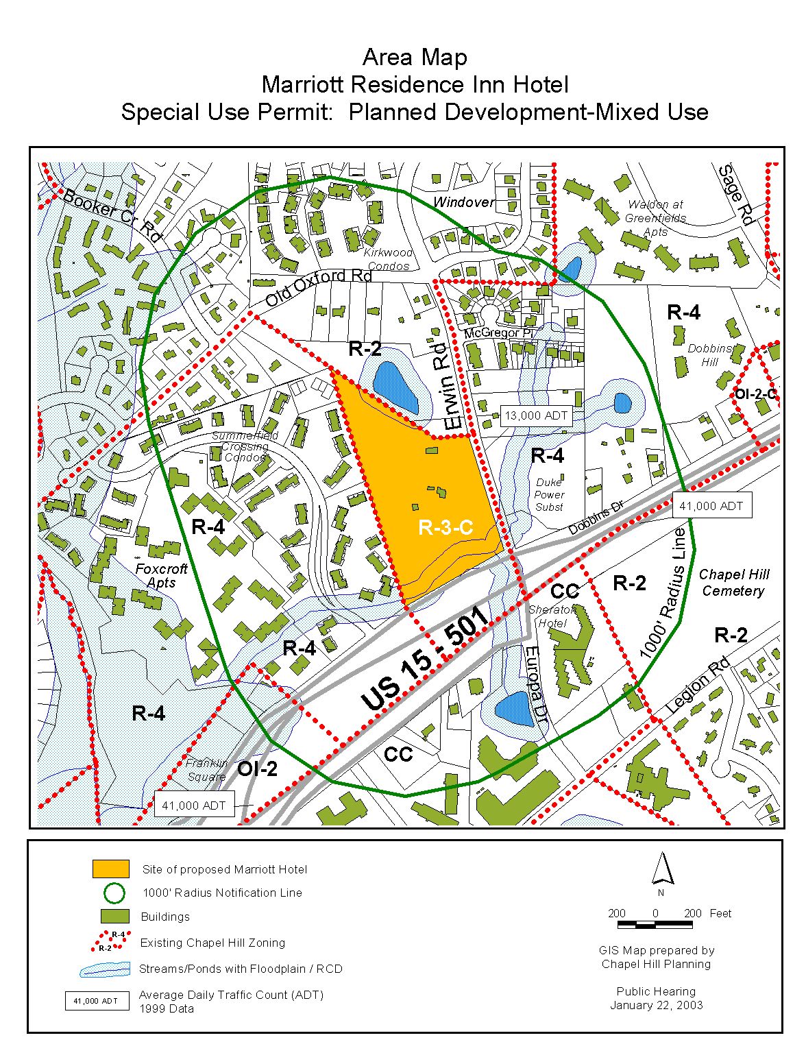
We have received and reviewed an application for a Special Use Permit for a Planned Development-Mixed Use proposal to construct a hotel, office and residential development at the northwest corner of the Erwin Road/Dobbins Drive intersection. The applicant is proposing a 73,120 square foot hotel complex with 108 lodging units. The proposal also includes a two-story, 6,000 square foot building containing 3,000 square feet of office space and 3,000 square feet of residential floor area. Overall, the application proposes 79,120 square feet of total floor area and 126 parking spaces. The property contains 13.29 acres of gross land area, and is located in the Residential-3-Conditonal (R-3-C) zoning district. The site is identified as Chapel Hill Township Tax Map 27, Block A, Lot 3.
Procedural considerations associated with this application are addressed in a box on the following page.
Tonight’s Public Hearing has been scheduled to receive evidence in support of and in opposition to approval of the application.
This package of materials has been prepared for the Town Council’s consideration, and is organized as follows:
· Cover Memorandum: Introduces application, describes process for review, summarizes staff and advisory board comments, and offers recommendations for Council action.
· Staff Report: Offers detailed description of site and proposed development.
· Attachments: Includes a checklist of requirements for this development, resolutions of approval and denial, advisory board comments, and applicant’s materials.
Procedural Note
The review of this proposal has been ongoing while discussions have continued about a new Land Use Management Ordinance to replace Chapel Hill’s existing Development Ordinance. Accordingly, there has been uncertainty about whether action on this application would take place under existing or new regulations. There has also been uncertainty about what form new regulations might take.
The applicant has made several adjustments to this proposal over the last six months, based in part on the status of discussions about new regulations. The result is that several presentations have been made to the Council and advisory boards, with variations in what is proposed.
The Planning Board originally was presented with tandem applications for rezoning and Special Use Permit. The Board recommended denial, and the applicant revised the application so as not to have to request a rezoning of the subject property. In light of possible changes to floor area ratios, the applicant further adjusted the proposal so as to comply with floor area ratios expected to be included in the new ordinance. Another key point is the pending set of decisions about the Resource Conservation District that the Council will be making.
The application that is before the Council tonight, accordingly, varies from plans reviewed by advisory boards. A “History of Board Reviews” is included in the attached Staff Report, tracking the status of this application. Some Boards reviewed plans that are very similar to the plans being presented tonight; for other boards, earlier versions were different.
Given the confluence of dates (January 22 Public Hearing, possible enactment of a new Land Use Management Ordinance on January 27), we have evaluated this application in the context of directions the Council has offered regarding what may be enacted as part of the new ordinance. We suggest that the Council, as is standard practice, hold this hearing open to allow follow-up to issues raised at the hearing. We believe that the appropriate procedure in this case is for the Council to hold the hearing open in a manner that allows final decisions on the Land Use Management Ordinance, and allows additional advisory board review of the applicant’s current proposal. We believe that all boards that typically review applications could arrange to have this current set of plans on an agenda during February.
Tonight’s application is for a Special Use Permit/Planned Development-Mixed Use on a 13.29 acre site in a Residential-3-Conditional (R-3-C) zoning district. The proposed application includes the following components:
· Hotel with 73,120 square feet of floor area, including 108 lodging units;
· Two-story 6,000 square foot building including 3,000 square feet of office space and 3,000 square feet of residential floor area; and
· 126 parking spaces.
Since the original submission of an application for a hotel on this site in April 2000, several key issues have emerged: 1) Traffic Impact Analysis; 2) Land Use Management Ordinance; and 3) Conformance with the Comprehensive Plan.
1) Traffic Impact Analysis: A Traffic Impact Analysis (TIA) for this project was prepared by the Town’s Consultant in accordance with the Town’s new Traffic Impact Analysis guidelines. The Traffic Impact Analysis was completed in September, 2002. We believe that the road improvements noted under the Access and Circulation Section in the attached Staff Report, and included in Resolution B, are consistent with the assumed improvements in the Traffic Impact Analysis.
2) Land Use Management Ordinance: The Council may enact the new Land Use Management Ordinance on January 27, 2002. We believe that the requirements enacted with the new Land Use Management Ordinance will apply to this proposed development.
3) Conformance with the Comprehensive Plan: As with previous proposals involving the development of a hotel on this site, our preliminary conclusion is that application does not conform to the Land Use Plan.
For additional discussion on these key facts, please refer to the Key Issues section in this memorandum.
BACKGROUND
March 23, 1998 Town Council approved both a Zoning Atlas Amendment that rezoned the site from Residential-2 (R-2) to Residential-3-Conditional (R-3-C), and a Special Use Permit for a Group Care Facility. The approved Special Use Permit allowed a Group Care Facility for 103 residents, and included 42,111 square feet of floor area and 58 parking spaces. The Group Care Facility was never built, and the Special Use Permit approval subsequently expired on March 24, 2000.
April, 2000 Applicant submitted a Special Use Permit application for a hotel and a Zoning Atlas Amendment application to rezone the site from Residential-3-Conditional (R-3-C) to Residential-4-Conditional (R-4-C).
May 3, 2002 Applicant requested that the Zoning Atlas Amendment application be revised to rezone the site from Residential-3-Conditional (R-3-C) to Community Commercial-Conditional (CC-C).
May 29, 2002, Town Council granted expedited processing for this application with a scheduled Public Hearing date of November 18, 2002.
October 1, 2002 Applicant presented a Special Use Permit and Conditional Zoning Atlas Amendment application to the Planning Board. The application included a three-story 85,500 square foot hotel with 120 lodging units and 120 parking spaces. Meeting continued to the Planning Board’s October 15, 2002 Meeting.
October 15, 2002 Continuation of the October 1, 2002 Planning Board Meeting.
October 25, 2002 Applicant withdraws the Zoning Atlas Amendment application.
November 6, 2002, Applicant submits an amended Special Use Permit application. Amended proposal included a smaller hotel (73,700 square foot hotel with 108 lodging units) and 120 parking spaces. New proposal also included 3,000 square feet of office and 3,000 square feet of residential floor area
November 12, 2002 Planning Board receives a Staff Report for a Special Use Permit application as proposed by the applicant on November 6, 2002. During the meeting the applicant presents a second amended application. Amended application further reduces the hotel (42,312 square feet with 80 lodging units), and provides less parking (92 spaces). Second revision continues to include 3,000 square feet of office space and 3,000 square feet of residential floor area. A summary of the November 12, 2002 Planning Board action can be found under the Recommendation section in this memorandum.
November 18, 2002 The Council held a Public Hearing on the Special Use Permit application as amended by the applicant (42,312 square foot hotel) during the November 12, 2002 Planning Board meeting. The Public Hearing was recessed until January 22, 2002.
January 8, 2002 Applicant submits a third amended application. This proposal includes a larger hotel (73,120 square feet with 108 lodging units) and 126 parking spaces and office and residential floor area (6,000 total square feet). This proposal is 580 square feet less than the hotel proposal submitted by the applicant on November 6, 2002.
PROCESS
The Development Ordinance requires the Town Manager to conduct an evaluation of this Special Use Permit/Planned Development-Mixed Use application, to present a report to the Planning Board, and to present a report and recommendation to the Town Council. We have reviewed the application and evaluated it against Town standards; we have presented a report to the Planning Board; and tonight we submit our report and preliminary recommendation to the Council.
The standard for review and approval of a Special Use Permit application involves consideration of four findings (description of the findings follows below). Evidence will be presented tonight. If, after consideration of the evidence, the Council decides that it can make each of the four findings, the Development Ordinance directs that the Special Use Permit shall then be approved. If the Council decides that the evidence does not support making one or more of the findings, then the application cannot be approved and, accordingly, should be denied by the Council.
One of the findings that the Council must make when considering a Special Use Permit application is:
That the use of development is located, designed, and proposed to be operated so as to maintain or enhance the value of contiguous property or that the use or development is a public necessity.
The Development Ordinance defines contiguous property as follows:
Contiguous Property: Property adjoining, neighboring, and nearby the outer boundary of a proposed development. For development proposals that are small in scale and similar in proposed use to existing uses in the immediate vicinity, contiguous property shall be construed to be those properties immediately adjacent. For large development proposals and/or proposed uses that are significantly different from existing uses nearby, or proposals that have significant topographic features that could impact nearby properties, contiguous property shall be construed to include those properties in a larger area, and those likely to experience negative impacts resulting from the proposed development. But in every case, for a proposal over 10 acres but less than 100 acres, at a minimum all property within 500 feet shall be considered contiguous; for development proposals that are over 100 acres, at a minimum all properties within 1,000 feet shall be considered contiguous.
The Town Attorney has advised that the Council should specify what area it considers to be contiguous property for each Special Use Permit application that comes before the Council for consideration. Since the proposed site is over 10 acres, the Development Ordinance requires that at a minimum, all property within 500 feet shall be considered contiguous. We note however, the Council may determine the contiguous property for this application extends beyond the minimum 500 feet requirement. Therefore, based on the Town Attorney’s advice to the Council, we suggest that prior to recessing the hearing this evening the Council discuss and determine by vote what should be considered contiguous property for this application. The attached Resolution E provides a format for determining the definition of contiguous property for this application.
EVALUATION OF THE APPLICATION
We have evaluated the application regarding its compliance with the expected standards and regulations of the Town’s new Land Use Management Ordinance. We have prepared a Staff Report that discusses intensity standards, access and circulation, parking, building elevations, buffers and landscaping, refuse management, utilities, and fire safety (and is included as an attachment to this memorandum). A checklist describing compliance with regulations is also provided as an attachment to this memorandum.
Based on our evaluation, our preliminary evaluation is that the application as submitted and amended, with the conditions that are recommended in the attached resolutions, would comply with the regulations and standards of the existing Development Ordinance and Design Manual.
We have also evaluated the application regarding its conformance with the Town’s Comprehensive Plan. We believe that, while the proposal may fulfill several of the goals and objectives of the adopted Comprehensive Plan, the proposal is not consistent with the adopted Land Use Plan which is a component of the Comprehensive Plan. This issue is further discussed in the upcoming “Key Issues” section of this memorandum (below) as well as the attached Staff Report.
The applicant has indicated that the application has been designed to comply with the regulations and policies of the Land Use Management Ordinance being considered by the Town Council.
Tonight the Council receives our attached evaluation, and also receives information submitted by the applicant and other citizens. The applicant’s materials are included as attachments to this memorandum. All information that is submitted at the hearing will be placed into the record.
Based on the evidence that is submitted, the Council will consider whether or not it can make each of four required findings for the approval of a Special Use Permit. The four findings are:
|
Special Use Permit – Required Findings of Fact
Finding #1: That the use or development is located, designed, and proposed to be operated so as to maintain or promote the public health, safety, and general welfare.
Finding #2: That the use or development complies with all required regulations and standards of this chapter, including all applicable provisions of Articles 12, 13, and 14 and with all other applicable regulations.
Finding #3: That the use or development is located, designed, and proposed to be operated so as to maintain or enhance the value of contiguous property, or that the use or development is a public necessity;
Finding #4: That the use or development conforms with the general plans for the physical development of the Town as embodied in this chapter and in the Comprehensive Plan. |
Following the Public Hearing, we will prepare an evaluation of the evidence submitted in support of and in opposition to this application. If, after consideration of the evidence, the Council decides that it can make each of the four findings, the Development Ordinance directs that the Special Use Permit/Planned Development-Mixed Use shall then be approved. If the Council decides that the evidence does not support making one or more of the findings, then the application cannot be approved, and accordingly, should be denied by the Council.
KEY ISSUES
Our full evaluation, with discussion of each of the required four findings, is included in the attached Staff Report. Based on the review of this development application by Town advisory boards and the Town staff, we believe that four key issues have been identified: 1) Conformance with the Comprehensive Plan; 2) Land Use Management Ordinance; 3) Traffic Impact Analysis; and 4) Dobbins Road Realignment. These issues are discussed below:
1) Conformance with the Comprehensive Plan: The May 8, 2000 Land Use Plan, which is a component of the Comprehensive Plan, identifies this property as low-density residential (1-4 units per acre). The applicant presents arguments in the accompanying Statement of Justification that the proposal fulfills statements and goals found in the overall Comprehensive Plan.
Staff Comment: We agree that the proposal addresses some of the general statements and goals in the Comprehensive Plan. We agree with several of the points made by the applicant. But a key point is that the May 8, 2000 Land Use Plan, a component of the Comprehensive Plan, identifies this property as low-density residential (1-4 units per acre). On balance, we do not believe that addressing general statements and goals in the Comprehensive Plan is sufficient to override the specific designation given to this particular property by the approved Land Use Plan. We note that this is a policy determination, and that the Town Council may reach a different conclusion.
We do not believe that the proposed use of this site for, as a hotel, is an appropriate land use. The proposed development site is located immediately to several residential neighborhoods. We are particularly concerned with the commercial nature of the proposed development and its visual intrusion into this residential area.
2) Land Use Management Ordinance: The Council has been working for almost two years on the development and enactment of a new Land Use Management Ordinance, which would replace the Town’s existing Development Ordinance. The Council is scheduled to adopt the Land Use Management Ordinance on January 27, 2003. If the Council takes action on the Land Use Management Ordinance on January 27 2003, it may choose to have the new Ordinance take effect immediately, or at some future specified effective date (to allow time for transition), and may take other actions that could determine its applicability to sending projects.
Staff Comment: It is possible that this application will be considered by the Council following the approval of the proposed Land Use Management Ordinance. We note that there are three regulatory changes in the proposed Land Use Management Ordinance, which may affect this application.
A. Floor Area Ratios: The current application proposes 79,120 square feet of floor area on the site. The existing Development Ordinance in a Residential-3 zoning district would permit a maximum of 51,424 square feet of hotel type floor area on the site. Under the existing Development Ordinance which presently governs this site, the applicant’s proposal does not conform to the required regulations and standards of the Development Ordinance.
As currently proposed the Land Use Management Ordinance will adjust floor area ratios in the Residential-3 zoning district and permit the applicant to construct a hotel on this site with 79,120 square feet of floor area.
B. Stormwater Management: The applicant is proposing to manage stormwater on the site through the use of two extended dry detention basins that would be designed to meet the Town’s current requirement that post-development stormwater runoff rate not exceed the pre development rate.
In addition to management of stormwater runoff rate, the proposed Land Use Management Ordinance would require this applicant to control stormwater runoff volumes. The applicant has agreed to meet this new stormwater standard. We recommend and Resolution A includes a stipulation that the applicant comply with the pending Land Use Management Ordinance standards with respect to quality, rate and volume of stormwater discharge.
C. Resource Conservation District: There is a perennial stream running along the site’s frontage on U.S. 15-501. The new Land Use Management Ordinance would define the RCD protected area in this location in a manner that increases the scope of coverage, compared to coverage under the current Development Ordinance. A key issue that the Council will determine, when it enacts the new ordinance, is defining the conditions under which old vs. new RCD boundaries apply to specific situations. As the Final Draft of the ordinance is written, a proposal for new development on this site (hotel) would be accompanied by the new RCD boundary. If the Council adopts the language that is in the Final Draft, the RCD boundary would expand for the context of this development proposal. In that case, the site plan would need to be adjusted, and the configuration of parking areas would need to be shifted.
3) Traffic Impact Analysis: The Traffic Impact Analysis (TIA) for this project was prepared by the Town’s Consultant in accordance with the Town’s new TIA guidelines. The Traffic Impact Analysis was completed in September, 2002.
We note that the applicant originally submitted a Traffic Impact Analysis (TIA) in August 2001 that was prepared by Kimley-Horn and Associates, Inc. This former Traffic Impact Analysis was based on project build-out in 2002. Noting that the applicant’s decision to delay the project caused the Kimley-Horn Traffic Impact Analysis to become out-of-date, the applicant chose to pay to have a new Traffic Impact Analysis (TIA) prepared for this project by the Town’s Consultant, in accordance with the Town’s new TIA guidelines.
We note that the September 2002 Traffic Impact Analysis was prepared with the assumption that the uses on the site would consist of an 85,500 square foot hotel with 120 lodging units. The applicant has since revised the proposal to reduce the hotel to 73,120 square feet with 108 lodging units, and include 3,000 square feet of office space and 3,000 square feet of residential space.
The Traffic Impact Analysis that was prepared by the Town’s Consultant in September 2002 concluded the following:
“In general, the additional traffic generated by the proposed Residence Inn is expected to have minimal impact to the surrounding roadway network with the improvements that are planned under the superstreet design, the Dobbins Drive/Erwin Road project, and the improvements that are deemed necessary regardless of whether the site is built out.”
Comment: The Traffic Impact Analysis Summary for the Proposed Residence Inn is provided as an attachment to this memorandum. We believe that the road improvements noted previously under the Access and Circulation Section, and included in Resolution B, are consistent with the assumed improvements in the Traffic Impact Analysis.
4) Dobbins Road Realignment: The applicant’s site plan identifies the dedication of public right-of-way along the Dobbins Drive service road, to correspond with the State’s preliminary plans to reconfigure this roadway (so that it lines up with the eastern intersection of Dobbins Drive and Erwin Road). We believe that this reconfiguration is a necessary improvement associated with the development of this site. Accordingly, we have included a stipulation in Resolution B that requires the developer to dedicate the necessary public right-of-way for the Dobbins Drive/Erwin Road reconfiguration project, as approved by the North Carolina Department of Transportation (NCDOT). In particular, Resolution B includes a stipulation that requires the developer to dedicate a 60-foot right-of-way along the realigned section of Dobbins Drive, including any additional right-of-way necessary to complete the reconfiguration project.
We recommend that the reconfiguration of the western Dobbins Drive/Erwin Road intersection should include a minimum of 26 feet of pavement, curb and gutter, and a 5-foot concrete sidewalk along one side of the road. We also recommend that these improvements be constructed prior to the construction and occupancy of this site. Accordingly, we have included a stipulation in Resolution B requiring the Dobbins Drive/Erwin Road reconfiguration improvements to be constructed prior to the issuance of a Certificate of Occupancy for this site.
Comment: We understand that the North Carolina Department of Transportation has funding to undertake the Dobbins Drive reconfiguration project, but that there is no funding for right-of-way acquisition. In addition, a local share cost must be provided for the project to be constructed. In May, 2002, the applicant, in coordination with Summit Hospitality Group, Ltd. and Marriott International, Inc., agreed to dedicate the right-of-way needed for the North Carolina Department of Transportation (NCDOT) to construct these roadway improvements related to the reconfiguration of the western Dobbins Drive/Erwin Road intersection. In addition, Marriott also offered to provide a payment to the Town of $82,550 to cover the local share cost for the project. On Tuesday January 8, 2003 the applicant provided the Town of Chapel Hill with a payment of $82,550. The Town is presently coordinating with NCDOT on this project.
SUMMARY
Resolution A, the Manager’s Preliminary Recommendation, recommends denial of the application. We have also attached Resolution B that includes standard conditions of approval as well as special conditions that we would recommend for this application if the Council makes the four findings necessary for approval. The key special conditions that we would recommend are described in detail in the accompanying Staff Report. The Manager’s recommendation incorporates input from all Town departments involved in review of the application.
Following is a brief outline describing the next steps in the development review process, should the Council approve the Special Use Permit/Planned Development-Mixed Use application for this site:
1. Applicant accepts and records a Special Use Permit/Planned Development-Mixed Use, which incorporates the terms of the Council-adopted resolution.
2. Applicant submits detailed Final Plans and documentation, complying with Council stipulations. Information is reviewed by Town departments and the following agencies:
3. Community Design Commission reviews and approves building elevations, site lighting and any alternate landscape bufferyard plans.
4. Upon demonstration of compliance with remaining Council stipulations, Town staff issues a Zoning Compliance Permit authorizing site work. Permit includes conditions specific to the development and requires pre-construction conferences with Town staff.
5. Engineering Department issues an Engineering Construction Permit, authorizing work within the public right-of-way; and
6. Inspections Department issues Building Permits and Certificates of Occupancy.
RECOMMENDATIONS
Recommendations are summarized below. Please see summaries of board actions and recommendations in the attachments.
Planning Board’s Recommendation: On October 1, 2002, the Planning Board reviewed a proposal for an 85,500 square foot hotel with 120 parking spaces. The Board deferred action until October 15, 2002. On October 15, 2002, the applicant requested a deferral in order to make revisions to the application.
On November 12, 2002, the Planning Board reviewed a proposal for a 43,812 square foot hotel, a 6,000 square foot building with 3,000 square feet of office and residential floor area and 92 parking spaces. The Planning Board voted 5-4 to recommend that the Council deny this application with the adoption of Resolution A. Please see the attached Summary of Planning Board Action.
Transportation Board’s Recommendation: On October 15, 2002, the Transportation Board reviewed a proposal for an 85,500 square foot hotel with 120 parking spaces. The Transportation Board deferred action pending further discussion, and intends to have this application on its agenda on January 21.
Community Design Commission’s Recommendation: On October 23, 2002, the Community Design Commission reviewed a proposal for an 85,500 square foot hotel with 120 parking spaces. The Community Design Commission voted 7-1 to recommend that the Council approve the application with the adoption of Resolution C. Please see the attached Summary of Community Design Commission Action.
Resolution C includes the following recommendation of the Community Design Commission:
1. That the site entrance on Erwin Road shall be moved as far north as possible, in order to provide greater separation for vehicles turning into this site, and those vehicles turning onto the realigned Dobbins Drive.
Comment: We note that the applicant’s proposed plans for Erwin Road improvements and a site entrance have been reviewed and endorsed by the North Carolina Department of Transportation (NCDOT). In addition, the Town Engineering Department has reviewed the plans and supports the proposed entrance driveway location as the preferred point of ingress and egress to the site from Erwin Road, given the sight distances and locations of other nearby intersections.
Bicycle and Pedestrian Advisory Board’s Recommendation: On October 22, 2002, the Community Design Commission reviewed a proposal for an 85,500 square foot hotel with 120 parking spaces. The Bicycle and Pedestrian Advisory Board voted 6-0 to not make a recommendation on this application. The Board then voted 5-1 to provide recommendations to the Council related to bicycle and pedestrian circulation and access issues. Please see the attached Summary of Bicycle and Pedestrian Board Action.
Resolution D includes the following recommendations of the Bicycle and Pedestrian Advisory Board:
1. That when Dobbins Drive is realigned, that the old section of Dobbins Drive should be converted to a bicycle/pedestrian path in order to provide bicycle and pedestrian access to the US 15-501/Erwin Road intersection.
Comment: The Dobbins Drive realignment project is being undertaken to decrease congestion and confusion at the intersections of Dobbins Drive and Erwin Road, and Erwin Road and US Highway 15-501. In particular, the proposed realignment of Dobbins Drive and Erwin Road is intended to increase safety for vehicles, bicycles and pedestrians at these both of these intersections.
Given that the Dobbins Drive realignment project will include a sidewalk along the north side of Dobbins Drive (as realigned) to Erwin Road, and the abandoned roadbed will be on the south side of Dobbins Drive, we do not recommend making this change. We believe that the best route of bicycle and pedestrian access from Dobbins Drive to US Highway 15-501 will be via the realigned roadway.
2. That improvements to Erwin Road should include wide outside lanes in both directions, instead of striped bicycle lanes on one side only.
Comment: We note that the applicant is proposing to dedicate right-of-way and provide a southbound bike lane on Erwin Road. Given the short stretch of Erwin Road on which this bike lane will exist, we do not expect that the bike lane proposed by the applicant will be striped.
Regarding the provision of an additional northbound bicycle lane (along the eastern side of Erwin Road), we do not believe that it is appropriate to ask the applicant for improvements on someone else’s street frontage. Perhaps more significantly however, we believe that it is preferable to obtain right-of-way for a northbound bicycle lane from the property owner(s) on the eastern side of the road, rather than providing the additional right-of-way on the western side of the road and thus necessitating a need to shift all of the vehicular travel lanes in such close proximity to the Erwin Road/US Highway 15-501 intersection.
Parks and Recreation Commission’s Recommendation: On November 20, 2002, the Parks and Recreation Commission reviewed a proposal and voted 8 to 0 to recommend that the Council approve the application with the adoption of Resolution E. Please see the attached Summary of Parks and Recreation Commission Action.
Resolution E includes the following recommendations of the Parks and Recreation Commission:
1. Complete the sidewalk along Dobbins Drive to the edge of the property.
2. Ensure that there is nothing to prohibit the future possibility of adding a connector trail from neighboring communities.
3. Include a loop trail within the property.
4. Ensure property owners on site unencumbered access to the recreation amenities by including this in the deed of property, this should include: no additional user fees for recreation access, suitable changing.
Manager’s Preliminary Recommendation: Based on our evaluation of the application, our preliminary conclusion is that the application does not conform with the Town’s Comprehensive Plan. Accordingly, we recommend that the Council adopt Resolution A, which would deny the Special Use Permit/Planned Development-Mixed Use application.
Following tonight’s Public Hearing, we will prepare an evaluation of the evidence submitted in support of and in opposition to this application. If the Council makes the required findings for approval of a Special Use Permit/Planned Development-Mixed Use, we recommend that the application be approved with the adoption of Resolution B.
Resolution C would deny the application as recommended by Planning Board.
Resolution D would approve the application as recommended by the Community Design Commission.
Resolution E would approve the application with the conditions recommended by the Bicycle and Pedestrian Advisory Board.
Resolution F would determine the definition of contiguous property for this application.
1. Staff Report (p. 15).
2. Project Fact Sheet Requirements (p. 28).
3. Resolution A (Denying the application) (p. 29).
4. Resolution B (Approving the application) (p. 30).
5. Resolution C (Denying the application) (p. 38).
6. Resolution D (Approving the application) (p. 39).
7. Resolution E (Approving the application) (p. 41).
8. Resolution F (Determining Contiguous Property) (p. 43).
9. Deleted.
10. Planning Board Summary of Action (p. 44).
11. Community Design Commission Summary of Action (p. 45).
12. Bicycle and Pedestrian Advisory Board Summary of Action (p. 46).
13. Parks and Recreation Summary of Action (p. 47).
14. Statement of Justification (p. 48).
15. Project Fact Sheet (p. 58).
16. Memo from Applicant, January 8, 2003 (p. 60).
17. Applicant’s Proposed Voluntary SUP Conditions, January 8, 2002 (p. 64).
18. GIS Area Map (p. 66).
19. Color Site Plan (p. 67).
20. Reduced Plans (p. 68).
21. Traffic Impact Analysis Summary (p. 74).