AGENDA #3b
to: Roger L. Stancil, Town Manager
from: J.B. Culpepper, Planning Director
Gene Poveromo, Development Manager
subject: Public Hearing: Woodmont Master Land Use Plan
date: May 12, 2008
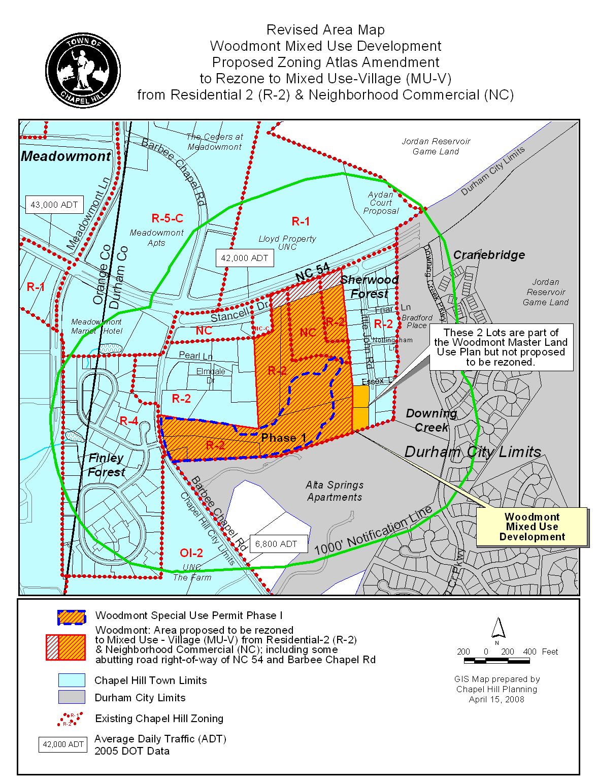
Attached for your consideration is a proposal for a Master Land Use Plan to allow 573,300 square feet of mixed use floor area (446,600 square feet of office; 148,900 square feet of residential, and 5,000 square feet of retail) at the site located on the south side of NC 54, between Barbee Chapel Road and Little John Road. Accompanying this application are applications for a Zoning Atlas Amendment and Special Use Permit. The site is identified as Durham County Parcel Identifier Numbers 9798-04-93-2035, 9798-04-92-0930, 9798-04-82-9499, 9798-04-82-6093, 9798-04-81-1816, 9798-04-71-8729, and 9798-04-82-6534.
A Master Land Use Plan is a conceptual plan (for development tracts of twenty acres or more) that conveys the general intent and system of development, by illustrating and defining land uses and circulation patterns.
Typically, the development encompassed by a Master Land Use Plan is proposed in phases, with a Special Use Permit application submitted for each phase.
Although the ordinance states that each Special Use Permit must be consistent with the Master Land Use Plan, it also allows for “minor changes” and “modifications” to the Master Land Use Plan. A minor change can be approved by the Town Manager; a modification must be approved by the Town Council, and is used for a change in boundaries, uses, landscaping, access and floor area/parking (of at least 5%).
Please refer to the section below regarding “Relationship to Special Use Permit” for a more detailed discussion.
During staff and advisory board review we identified five key issues related to this project:
1. Traffic Impacts on NC 54 and Barbee Chapel Road: Concerns were voiced at both Planning Board meetings regarding the capacity of Barbee Chapel Road and NC 54 to handle additional traffic associated with the proposed development.
Comment: We rely on the results of the Traffic Impact Analysis to determine our transportation recommendations for development. The Traffic Impact Analysis projects 5,000 trips per day generated by the proposed use. The analysis also includes delay-based level of service (LOS) comparisons for existing intersections, with and without the recommended improvements.
For the NC 54/Barbee Chapel Road intersection:
Existing LOS: “E” for the AM peak hour, “B” for the PM peak hour
Without improvements: “F” for AM peak hour, “C” for PM peak hour
With improvements: “D” for AM peak hour, “C” for PM peak hour
For the NC 54/ Office Driveway Intersection:
Existing LOS: “A” for AM and PM peak hours
Without improvements: “A” for AM peak hour, “B” for PM peak hour
With improvements: “A” for AM peak hour, “B” for PM peak hour
For more information about the projected impacts on existing capacity, please refer to the Traffic Impact Analysis and Comprehensive Traffic Analysis for Woodmont and Aydan Court (Attachments 5 and 13).
2. Mixed Use/Transit-Oriented: At the April 1, 2008 Planning Board meeting, Planning Board members questioned the mix of uses proposed for the development (particularly Phase I). Although the Long Range Transit Plan is expected to identify the site as a potential location for transit-oriented development, the Planning Board questioned whether the proposed development has the appropriate intensity and design of a mixed use or transit-oriented development.
Comment: The “Mixed Use-Village” zoning designation proposed for this property requires that the mix of floor area within a proposed development contain at least twenty-five (25) per cent of the floor area devoted to residential uses and at least twenty-five (25) per cent of the floor area devoted to office/commercial uses. The application proposes to comply with this requirement.
The advantages of this type of mixed use development include the potential for internal trip capture (for example residents shop or work nearby, without having to access retail or office by car), and associated reduced impact on the environment, potential to cluster development so as to preserve environmentally sensitive areas, as well as the creation of community and vibrancy in a destination that serves multiple needs. We believe that although the Woodmont development may not achieve the vibrant destination often associated with larger mixed-use, transit-oriented development, when viewed in the context of the larger geographic area which includes the adjacent residential developments, and potential nearby retail redevelopment, the Woodmont proposal will create an opportunity for trip capture and have the basic components to encourage transit use.
3. Stancell Drive closing: The applicant proposes to close two portions of Stancell Drive, in order to address concerns about cut-through traffic.
Comment: We do not recommend closing portions of Stancell Drive as requested by the Applicant because of the following reasons:
Also, the staff proposes an alternate roadway configuration, which would include an ‘S’ curve alignment (“jug handle”) of Stancell Drive. The realignment of the street would mitigate potential turning movement conflicts at the future intersection of Stancell Drive and the primary site access to NC 54. Resolution A includes a stipulation for the ‘S’ curve alignment (as part of Phase II improvements).
We also recommend that the portion of Stancell Drive along the Woodmont property frontage be improved to Town standard, with curb and gutter and sidewalks, and have included a stipulation to that effect in Resolution A.
4. Master Land Use Plan Modifications: Questions about modifying the Master Land Use Plan and whether the rebuttable presumption reflects the original, or modified, Master Land Use Plan arose at the Community Design Commission meeting.
Comment: According to Section 4.8.3(k) of the Land Use Management Ordinance, a modification to the Master Land Use Plan can be made for the following reasons if approved by the Council:
A. A change in the boundaries of the site;
B. A change from the use(s) approved by the Town Council;
C. A change in the floor area or number of parking spaces approved by the Town Council by at least five percent;
D. Changes in pedestrian and bicycle or vehicular access or circulation approved by the Town Council which:
1. Change trip distribution involving more than five percent of all projected trips; or
2. Reduce the level of service (LOS) of a street link or intersection within one-quarter of a mile from the boundaries of the proposed development
E. Substantial change in the amount or location of landscaped and open areas
5. Parking Spaces: The original Staff Report for the Woodmont Master Land Use Plan included a recommendation for 1,702 parking spaces.
Comment: Because the Master Land Use Plan is meant to be a conceptual plan, we do not recommend including specific parking numbers in the resolution of approval, but do recommend that Special Use Permit applications include specific parking numbers.
Planning Board: The Planning Board met on April 29, 2008 to allow the applicant to respond to concerns expressed by the Planning Board during the April 1, 2008 meeting. We anticipate handing out the recommendation from their May 6, 2008 meeting at tonight’s public hearing.
Bicycle and Pedestrian Advisory Board: The Bicycle and Pedestrian Advisory Board met on March 25, 2008 and voted 7-0 to recommend that the Council approve the Master Land Use Plan with the adoption of the Resolution attached to the Advisory Board memorandum with the following change:
· Permit angled on-street parking
Comment: We have not incorporated this change into Resolution A, because the Town’s design standards discourage angled parking. We understand that the applicant may ask for a modification to this standard at tonight’s public hearing.
A copy of the Summary of Bicycle and Pedestrian Advisory Board Action is attached.
Greenways Commission: The Greenways Commission met on March 26, 2008 and the Commission voted (5-0) to recommend approval of the Master Land Use Plan with the following added stipulation:
· That the applicant provide active recreation space to meet the Land Use Management Ordinance requirements, with the option for payment-in-lieu for unmet recreation space requirements, subject to Town Manager approval.
Comment: We have incorporated this change into Resolution A.
Parks and Recreation Commission: The Parks and Recreation Commission met on April 16, 2008 and voted (8-1) to recommend adoption of the Master Land Use Plan with wording to allow a payment-in-lieu for recreation space (see above).
A copy of the Summary of Parks and Recreation Commission Action is attached.
Comment: We have incorporated this change into Resolution A.
Community Design Commission: The Community Design Commission met on April 16, 2008 and voted (8-0) to recommend approval of the Master Land Use Plan with the following condition:
· That the total amount of square footage of retail space be increased by Phase 3; that the Phase 1 development include 5,000-8,000 square feet of retail space; and that Phase 2 also include retail space.
A copy of the Summary of Community Design Commission Action is attached.
Comment: We did not incorporate the stipulation regarding retail floor area because the recommended Resolution does not allocate floor area uses.
Transportation Board: The Transportation Board met on April 24, 2008 and voted 4-1 to recommend approval of the Master Land Use Plan.
Staff’s Preliminary Recommendation: If the property is rezoned to Mixed Use-Village, our preliminary recommendation is that the Council adopt Resolution A, approving the Master Land Use Plan with conditions.
The revised Resolution deletes authorization of 1,702 parking spaces.
A copy of a matrix comparing the differences between the above recommendations is included at the end of this memorandum.
PROCESS
The Land Use Management Ordinance requires the Town Manager to conduct an evaluation of this Master Land Use Plan application, to present a report to the Planning Board, and to present a report and recommendation to the Town Council. We have reviewed the application and evaluated it against Town standards; we have presented a report to the Planning Board; and tonight we submit our report and preliminary recommendation to the Council.
RELATIONSHIP TO SPECIAL USE PERMIT
The Land Use Management Ordinance states that “if a Master Land Use Plan is approved for a tract of land, and an application for a Special Use Permit is subsequently received, then the Special Use Permit application must be consistent with the master plan. If it is consistent with the master plan, a rebuttal presumption shall thereby be established that the proposed development would:
These are three of the four findings that must be made to approve an application for Special Use Permit. The fourth finding, “that the use or development complies with all required regulations and standards of this chapter, including all applicable provisions of articles 3 and 5, the applicable specific standards contained in the supplemental use regulations (article 6), and with all other applicable regulations,” is the only finding that must then be made by the Council in order to approve the Special Use Permit application with an approved Master Land Use Plan.
EVALUATION OF THE APPLICATION
We have evaluated the application regarding its compliance with the standards and regulations of the Town’s Land Use Management Ordinance. Based on our evaluation, our preliminary conclusion is that the application as submitted complies with the required findings, with the conditions included in Resolution A.
Tonight the Council receives our attached evaluation and information submitted by the applicant. The applicant’s materials are included as attachments to this memorandum. All information that is submitted at the hearing will be included in the record of the hearing. Based on the evidence submitted, the Council will consider whether or not it can make the three findings:
|
Master Land Use Plan – Required Findings of Fact Finding #1: Maintain the public health, safety, and general welfare; Finding #2: Maintain or enhance the value of contiguous property, or be a public necessity; and Finding #3: Conform to the comprehensive plan. |
Following the Public Hearing, we will prepare an evaluation of the evidence submitted in support of and in opposition to this application.
SUMMARY
We have attached a resolution that includes standard conditions of approval as well as special conditions that we recommend for this application. With these conditions, if the property is rezoned to the requested Mixed Use-Village zoning district, our preliminary recommendation is that the Council could make the finding necessary in order to approve the application. Our recommendation, Resolution A, incorporates input from all Town departments involved in review of the application.
Woodmont Master Land Use Plan Application
DIFFERENCES AMONG RECOMMENDATIONS
|
ISSUES |
Staff’s Preliminary |
Planning Board |
Bicycle/ Pedestrian Advisory Board |
Greenways/Parks and Recreation Commission |
Community Design Commission |
|
Angled Parking |
No angled on-street parking |
* |
Angled on-street parking permitted |
*
|
* |
|
Recreation Space Payment in Lieu |
yes |
* |
* |
yes |
* |
|
Additional Retail Floor Area |
N/A |
* |
* |
* |
yes |
|
Specific Number of Parking Spaces Approved |
no |
* |
* |
* |
* |
|
Park and Ride spaces |
yes |
* |
* |
* |
* |
* = Issues not discussed, and therefore not included in the Resolution
[11.1 Community Design Commission Summary of Action]