|
TO: |
Roger L. Stancil, Town Manager |
|
FROM: |
J.B. Culpepper, Planning Director Gene Poveromo, Development Coordinator |
|
DATE: |
January 8, 2007 |
|
SUBJECT: |
The Residences at Chapel Hill North – Request for Partial Revocation of the Chapel Hill North Phase I Special Use Permit and Application for a Phase II Special Use Permit (PIN 9880-36-1885) |
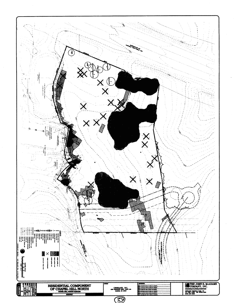
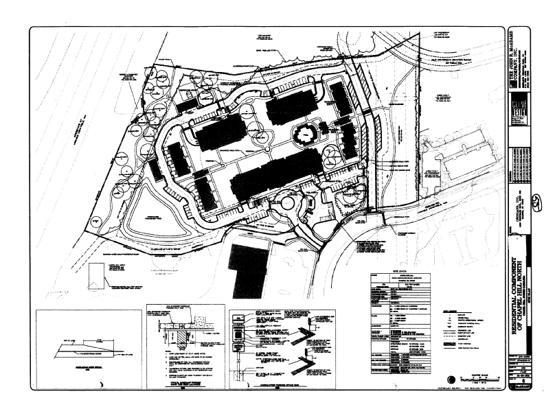
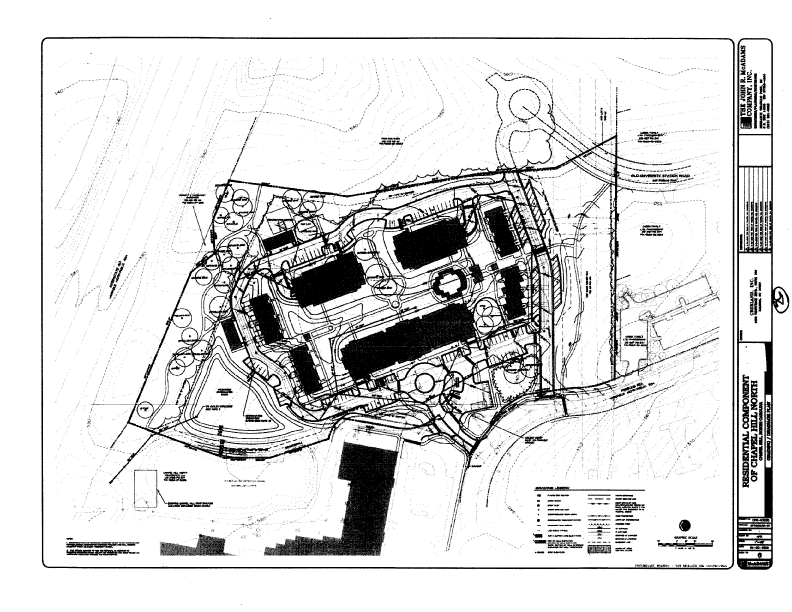
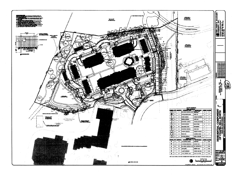
Tonight, the Council continues the Public Hearing from October 18, 2006, regarding 1) a request for a partial revocation of the Chapel Hill North Phase I Special Use Permit and 2) an application for a Phase II Special Use Permit. The proposed multi-family planned development would consist of 10 buildings containing 123 dwelling units and 238 parking spaces, including a clubhouse and garages, on an approximately 13-acre site. The site is located in the northeast portion of the Chapel Hill North Shopping Center, off of Perkins Drive. The site is located in the Mixed Use-Office/Institutional-1 (MU-OI-1) zoning district. The site is also identified as Orange County Parcel Identifier Number 9880-36-1885.
Prior to approval of the Chapel Hill North Phase II Special Use Permit application, we recommend that the Council approve the request for a Partial Revocation of the Chapel Hill North Phase I Special Use Permit with the adoption of Resolution A. This action and the enactment of the accompanying Land Use Management Ordinance Text Amendment are required prior to adoption of the application for the Chapel Hill North Phase II Special Use Permit. Please refer to the Key Issues section of the memorandum and the accompanying text amendment application for additional information on this matter.
Based on the information in the record to date, we believe that the Council could make the findings required to approve the Special Use Permit application. We recommend that the Council adopt Resolution B, approving the application.
This package of materials has been prepared for the Town Council’s consideration, and is organized as follows:
The following key issues were raised during the October 18, 2006 Public Hearing:
Comment: The applicant has provided a revised site plan with a proposed 30-foot wide right-of-way, including travel lanes and curb and gutter that connects Perkins Drive with Old University Station Road. The parking along the connecting road has been reconfigured with fewer 45 degree parking spaces. Please see revised plans, Sheet 5 (Attachment 2). We have included a stipulation in Revised Resolution B that will require the public road connection.
Comment: The applicant has made an affordable housing proposal that is attached (Attachment 3). A list of those concerns, as related to the applicant’s proposal include:
We have identified several concerns regarding the applicant’s Affordable Housing Proposal:
We have several areas of concern regarding the applicant’s proposal. We believe that the staff recommendation requiring the applicant to receive Town Manager approval of an Affordable Housing Plan, prior to issuance of a Zoning Compliance Permit, is preferable to the current applicant’s proposal. It permits staff to study an affordable housing proposal with guidance from the Town Attorney, Town staff, and local affordable housing specialists.
If the Council chooses to rely on the Town Attorney and the staff to approve the details of an Affordable Housing Plan prior to issuance of a Zoning Compliance Permit, we would incorporate the recommended changes identified above.
Comment: At their October 17, 2006 meeting, the Planning Board made a recommendation to the Town Council that the Council initiate a traffic study or the like, to determine the combined effects of proposed development in the Northwest Area of Town (Attachment 5).
Town staff is drafting an agenda item, in response to a citizen petition, which will go before the Council on January 22, detailing current planning efforts to address transportation issues, including bike and pedestrian initiatives, in the northwest portion of Chapel Hill. There are several initiatives currently underway in this area. These include the NC 86/Martin Luther King, Jr. Boulevard pedestrian safety implementation plan and the Active Living By Design Timberlyne neighborhood pedestrian mobility assessment. In addition it is anticipated that the North Carolina Department of Transportation project to provide sidewalks, bike lanes and pedestrian crossing improvements along Weaver Dairy Road will be initiated in 2011.
Comment: The applicant has provided a response to the Council inquiry regarding stormwater management on the site (Attachment 4). The applicant argues against providing one enlarged basin rather than two adjacent basins. The principal reasons given for their conclusion are that 1) the depth to bedrock in the existing basin may be inadequate to accommodate the additional volume required to properly treat the new stormwater runoff, 2) the design standards for stormwater treatment were different when the original pond was built than that required for the current development, and 3) expanding and reconstructing the existing pond onto the subject site would have significant engineering problems. An additional complicating factor that the applicant failed to note is that the adjacent basin is on a separate property thereby requiring an offsite stormwater management and construction agreement with the neighboring property owner. We agree with the applicant that in this case a single basin solution for managing stormwater would be problematic. Revised Resolution B, the staff recommended resolution, continues to allow the two adjacent basins.
Comment: A Master Land Use Plan is defined as a conceptual plan that illustrates and defines land uses for development tracts of 20 acres or more. General vehicular and pedestrian circulation patterns are identified and indicated on Master Land Use Plans. Once a Master Land Use Plan has been approved for a property, no further development approval can be granted unless it is consistent with the Master Plan or the Master Land Use Plan is modified.
With Council approval of a conceptual Master Land Use Plan, if a Special Use Permit application associated with a Master Land Use Plan is found to be consistent with the Master Plan, a “rebuttable presumption[1]” is established that three of the four findings required for approval of a Special Use Permit have already been made (#1, 3 and 4 below). The Council must only make the finding that the proposed development complies with all applicable sections of the Land Use Management Ordinance (#2 below).
The establishment of rebuttable presumption shifts the burden of evidence, concerning findings 1, 3 and 4 to those opposed to approval of the permit.
The Master Land Use Plan for Chapel Hill North was approved by Council January 23, 1990 (Part of Attachment 14). The proposed Phase II Special Use Permit must be found to be consistent with the Master Land Use Plan in order to be approved.
This application has an accompanying Land Use Management Ordinance Text Amendment that proposes to expand the mix of uses permitted in the underlying Mixed Use-Office/Institutional-1 (MU-OI-1) zoning district and therefore does not require a Modification of the Master Land Use Plan.
We believe that the residential proposal is consistent with the conceptual master plan from 1990 with the expanded mix of uses permitted in the zoning district.
Comment: The Traffic Impact Analysis was revised at the request of Town staff, because the original analysis was based on a build date of 2007. The build date in the new analysis is 2009. Please refer to the revised Executive Summary of the Traffic Impact Analysis, a staff overview, as well as North Carolina Department of Transportation recommendations (Attachments 11 and 12).
Related to the revised Traffic Impact Analysis is the issue of traffic stacking on Perkins Drive at the intersection of Martin Luther King, Jr. Boulevard. The current configuration at this intersection is three lanes, 1) one inbound lane from Martin Luther King, Jr. Boulevard, 2) one left-turn lane into Martin Luther King, Jr. Boulevard from Perkins Drive, and 3) one right-turn lane into Martin Luther King, Jr. Boulevard from Perkins Drive. There is an existing tendency for traffic to stack in the single left-turn lane on Perkins Drive back to the entrance to the Harris Teeter shopping center on the north side of Perkins Drive. The proposed development will exacerbate that problem. We are recommending that the applicant convert the existing right-turn only lane from Perkins Drive into Martin Luther King, Jr. Boulevard to a right/left turn lane with new turn arrows. We believe this will mitigate the problem somewhat but will probably not prevent the stacking problem entirely.
As regards traffic impacts, the Master Land Use Plan for the Chapel Hill North site had approved office use on the site where the Residences at Chapel Hill North is being proposed. We believe the previously approved office use, rather than the proposed residential use, would be expected to generate more traffic.
The preferable solution would be for the applicant to obtain right-of-way and an additional left turn lane from Perkins Drive into Martin Luther King, Jr. Boulevard. This solution is not possible as the property south of Perkins Drive does not belong to the applicant. We recommend that any future development to the south of Perkins Drive be required to include right-of-way dedication as part of their proposal.
Comment: We have provided a graphic that indicates the existing, proposed, and planned future sidewalks (Attachment 13).
Comment: Our revised recommendation includes stipulations that address bike sensitive traffic signals and pedestrian signal crossings, including 1) signal retiming, and 2) crosswalks, pedestrian signals, and bicycle activated signal loops at the Perkins Drive/Martin Luther King, Jr. Boulevard intersection.
Comment: The applicant has indicated that lighting for the existing development is provided by 1) public street lighting and 2) parking lot and sidewalk lighting on the private commercial lots in Chapel Hill North. Also, all public street lighting is on the west/south side of Perkins Drive. Some of the fixtures are shown on the Area Map (Sheet 3) of revised plans. The applicant has also indicated that the proposed development plan does not currently show either public street lighting or parking lot lighting. The applicant anticipates that public street lighting will be on the south side of the proposed public road crossing the site. The exact location of proposed fixtures will be established during Final Plan review and stipulations in Resolution B require that the Community Design Commission and Duke Energy approve lighting plans.
EVALUATION OF THE APPLICATION
The standard for review and approval of a Special Use Permit application involves consideration of four findings of fact that the Council must consider for granting a Special Use Permit. Based on the evidence that is accumulated during the Public Hearing, the Council will consider whether it can make each of the four required findings for the approval of a Special Use Permit. If, after consideration of the evidence submitted at the Public Hearing, the Council decides that it can make each of the four findings, the Land Use Management Ordinance directs that the Special Use Permit shall then be approved. If the Council decides that the evidence does not support making one or more of the findings, then the application cannot be approved and, accordingly, should be denied by the Council.
With Council approval of the 1990 Master Land Use Plan, if the Special Use Permit application is found to be consistent with the Master Plan, the burden regarding three of the four findings then shifts to those opposed to approval of the Permit. A “rebuttable presumption” is established that three of the four findings have already been made (#1, 3 and 4 below). The Council must only make the findings that the proposed development is consistent with the Master Land Use Plan and complies with all applicable sections of the Land Use Management Ordinance (#2 below). Please also refer to the Key Issues Section for additional information.
Tonight, based on the evidence in the record thus far, we provide the following evaluation of this application based on the two findings of facts that the Council must consider for granting a Special Use Permit.
Finding #1: Master Land Use Plan Consistency Finding.
We believe the evidence in the record to date can be summarized as follows:
Evidence in support: We believe that with the accompanying text amendments to Subsections 3.5.1(e)(2) and 3.5.1(e)(3)(A-E) of the Land Use Management Ordinance, expanding the mix of uses and ratios of uses permitted in the Mixed Use-Office/Institutional-1 (MU-OI-1) zoning district, the proposed Phase II Special Use Permit application is consistent with the Master Land Use Plan, approved January 23, 1990 (Part of Attachment 14).
Evidence in opposition: We have received several letters from neighbors concerned about traffic impacts and pedestrian connections associated with the proposed development. Please see Attachment 10.
We anticipate that further evidence may be presented for the Council’s consideration as part of the continued Public Hearing process.
Finding #2: That the use or development complies with all required regulations and standards of the Land Use Management Ordinance, including all applicable provisions of Articles 3 and 5, the applicable specific standards in the Supplemental Use Regulations (Article 6) and with all other applicable regulations.
We believe the evidence in the record to date can be summarized as follows:
Evidence in support: Evidence in support of this finding for the application has been provided by the applicant’s Statement of Justification (Part of Attachment 14).
We note the following points from the applicant’s Statement of Justification:
Please see the applicant’s Statement of Justification for additional evidence in support of the application (Part of Attachment 14).
Evidence in opposition: We have not identified any evidence offered in opposition to Finding #2.
We anticipate that further evidence may be presented for the Council’s consideration as part of the continued Public Hearing process.
We have attached a resolution that includes standard conditions of approval as well as special conditions that we recommend for this application. With these conditions, our conclusion is that the Council could make the finding necessary in order to approve the application. The staff recommendation incorporates input from all Town departments involved in review of the application.
The Planning Board, Transportation Board, Community Design Commission, Bicycle and Pedestrian Advisory Board, and Greenways Commission all voted to recommend 1) that the Council enact the ordinance amending the text to Subsections 3.5.1(e)(2) and 3.5.1(e)(3)(A-E) of the Land Use Management Ordinance, expanding the mix of uses and ratios of uses permitted in the Mixed Use-Office/Institutional-1 (MU-OI-1) zoning district, and 2) to adopt Resolution A to the Council, to partially revoke the Chapel Hill North Phase I Special Use Permit.
Planning Board: On October 17, 2006, the Planning Board voted 4-3 to recommend that the Council adopt Resolution C, with conditions, approving the Phase II Special Use Permit. Please see the Planning Board Summaries of Action (Attachment 5).
Community Design Commission: On November 15, 2006, the Community Design Commission voted 5-0 to recommend that the Council approve the Special Use Permit application with the adoption of Resolution E with conditions. Please see the attached Summary of Community Design Commission Summary of Action (Attachment 7).
Bicycle and Pedestrian Advisory Board: On November 28, 2006, the Bicycle and Pedestrian Advisory Board voted 7-0 to recommend that the Council adopt Resolution F, with conditions. Please see the attached Summary of Bicycle and Pedestrian Advisory Board Action (Attachment 8).
Greenways Commission: On October 25, 2006, the Greenways Commission voted 6-0 to recommend that the Council adopt Resolution G, with conditions. Please see the attached Greenways Commission Summary of Action (Attachment 9).
Transportation Board: On November 30, 2006, the Transportation Board voted 8-0 to recommend that the Council approve the Special Use Permit application with the adoption of Resolution D with conditions. Please see the attached Summary of Transportation Board Action (Attachment 6).
Please refer to the summary chart of the differences among resolutions.
Additional Recommendations Incorporated into the Staff Recommendation, Revised Resolution B:
Following the October 18 Public Hearing, the following recommendations have been incorporated into Resolution B, the Staff Revised Recommendation:
Comment: This new recommendation is based on information in the revised Traffic Impact Analysis. See Key Issues Section for additional detail.
Comment: The Greenways Commission has recommended that the applicant provide a pedestrian trail across the northern portion of the site. We concur.
Comment: This recommendation provides specific language for access and maintenance of the northern and southern pedestrian trails.
Comment: This recommendation is based on comments from the revised Traffic Impact Assessment and the North Carolina Department of Transportation. We concur that the recommended median on Weaver Dairy Road would be more effective than our preliminary recommendation for a pork chop at this intersection to limit traffic movements to right-in/right-out.
Comment: The intent of this recommendation is to provide improved pedestrian connections to the Timberlyne Shopping Center.
Comment: The intent of this recommendation is to provide improved pedestrian connections to the Timberlyne Shopping Center.
Comment: The intent of this recommendation is to provide improved pedestrian connections to the Timberlyne Shopping Center. We recommend the above sidewalk segment include a pedestrian refuge between the two pedestrian cross walks that will connect the north and south sides of Weaver Dairy Road to provide a pedestrian connection to the Timberlyne Shopping Center, based on the revised Traffic Impact Analysis.
Comment: This recommendation is based on the revised Traffic Impact Assessment. See Key Issues Section.
Comment: This recommendation is based on new information.
Comment: This recommendation is based on new information and will provide for more durable pavement markings.
The Following Stipulations Were Deleted From Resolution B:
•
Vehicular Stub out to East: That the applicant shall
provide a vehicular stub-out for a future connection to the property to the
east. The stub-out shall be constructed to Town standard with a 27-foot wide
cross-section, back of curb to back of curb, and a 5-foot wide sidewalk on the
southern side of the driveway. The location and design shall be subject to Town
Manager approval, prior to issuance of a Zoning Compliance Permit.
Comment: This recommendation is no longer necessary because the applicant has agreed to provide vehicular right-of-way across the southern portion of the site between Perkins Drive and Old University Station Road.
•
Old University Station Road Public
Right-Of-Way Dedication: That the applicant shall dedicate a 60-foot wide
public right-of-way to the Town on the portion of Old University Drive that
crosses the southeast corner of the applicant’s property, subject to Town
Manager approval, prior to issuance of a Zoning Compliance Permit.
Comment: This recommendation is not necessary as we have learned that public right-of-way already exists on this portion of the applicant’s site.
•
Old University Station Road and Sidewalk Extension:
That the applicant shall construct a 27-foot wide street cross-section with
30-inch curb and gutter, extending to the existing street, and a 5-foot wide
sidewalk on the west side of the street, extending to the existing sidewalk,
built to Town Standard, subject to Town Manager approval, prior to issuance of
a Zoning Compliance Permit.
Comment: This recommendation is no longer necessary because the Old University Station Road public right-of-way would not be connected until future development is proposed in this area.
Staff’s Revised Recommendation: Based on our evaluation of the application, our revised conclusion is that, with the stipulations in Revised Resolution B, the Special Use Permit application complies with the standards and regulations of the Land Use Management Ordinance.
We recommend that the Council adopt Resolution A, approving the request for a Partial Revocation of the Chapel Hill North Phase I Special Use Permit with conditions.
We recommend that the Council then adopt Revised Resolution B, approving the Phase II Special Use Permit application with conditions.
Resolution C would approve the application as recommended by the Planning Board.
Resolution D would approve the application as recommended by the Transportation Board.
Resolution E would approve the application as recommended by the Community Design Commission.
Resolution F would approve the application as recommended by the Bicycle and Pedestrian Advisory Board.
Resolution G would approve the application as recommended by the Greenways Commission.
Resolution H would deny the application.
The Residences at Chapel Hill North - Special Use Permit
Differences Among Resolutions
|
Issues |
(Approval)
Staff Revised Rec. |
Resolution C (Approval)
Planning Board Rec. |
(Approval)
Transportation Board Rec. |
Resolution E (Approval)
Community Design Commission Rec. |
Resolution F (Approval)
Bicycle and Pedestrian Advisory Board Rec. |
(Approval)
Greenways Commission Rec. |
|
Provide Bus Service Along Perkins Drive to Serve Development |
To Be Determined By Chapel Hill Transit |
* |
Yes |
* |
* |
* |
|
Provide Right-In/Right Out Drive at Perkins/WD Rd. |
Yes |
Yes |
* |
Yes |
* |
* |
|
Provide Public ROW btwn Perkins & Old University Station Rd. |
30-Foot Width |
Yes |
Yes |
45-Foot Width |
Yes |
Yes |
|
Fencing Around Play Area |
Yes |
* |
* |
* |
* |
Yes |
|
Northern Greenway Trail Connection to Westernmost Access Drive |
Yes |
* |
* |
* |
* |
Yes |
|
Greenway Trail Maintenance |
Owner of Chapel Hill North Site & Permitting Periodic Town Maint. |
* |
* |
* |
* |
Owner of Chapel Hill North Site & Permitting Periodic Town Maint |
*Issue not discussed at this particular meeting and is therefore not included in this Resolution. 12/21/06
Residences at Chapel Hill North Shopping Center |
Compliance |
Non-Compliance |
|
Use Permitted |
✓ (With approval of the corresponding Land Use Management Ordinance Text Amendment) |
|
|
Min. Gross Land Area |
✓ |
|
|
Min. Lot Size |
✓ |
|
|
Min. Lot Width |
✓ |
|
|
Max. Floor Area |
✓ (With approval of the corresponding Land Use Management Ordinance Text Amendment) |
|
|
Impervious Surface Limits |
✓ High Density Option |
|
|
Treatment of Stormwater Quality, Volume, and Rate |
✓ |
|
|
Min. Recreation Area/Space |
✓ |
|
|
Min. # Vehicular Parking Spaces |
✓ |
|
|
Min. # Bicycle Parking Spaces |
✓ (With conditions) |
|
|
Max. # Dwelling Units |
✓ |
|
|
Min. Street Setback |
✓ |
|
|
Min. Interior Setback |
✓ |
|
|
Min. Solar Setback |
✓ |
|
|
Max. Height Limit |
✓ |
|
|
Min. Landscape Buffers |
✓ (If alternate buffers approved on southern and western boundaries) |
|
|
Steep Slopes |
✓ |
|
|
Resource Conservation District |
NA |
|
|
100-Year Floodplain and Floodway |
NA |
|
|
Watershed Protection District |
NA |
|
|
Adequate Public Schools Facilities |
✓ |
|
|
Section 6.18 (Planned Developments) |
✓ |
|
NA = Not Applicable Prepared: September 27, 2006
[1] The definition of a “rebuttable presumption” is an assumption that is made that is taken to be true unless someone comes forward to contest it and prove otherwise.