|
MEMORANDUM |
|
|
TO: |
Roger L. Stancil, Town Manager |
|
FROM: |
J.B. Culpepper, Planning Director Gene Poveromo, Development Coordinator |
|
SUBJECT: |
Public Hearing: Bradley Ridge Preliminary Plat Cluster Subdivision (File No. 9880-96-7441) |
|
DATE: |
January 23, 2008 |
INTRODUCTION
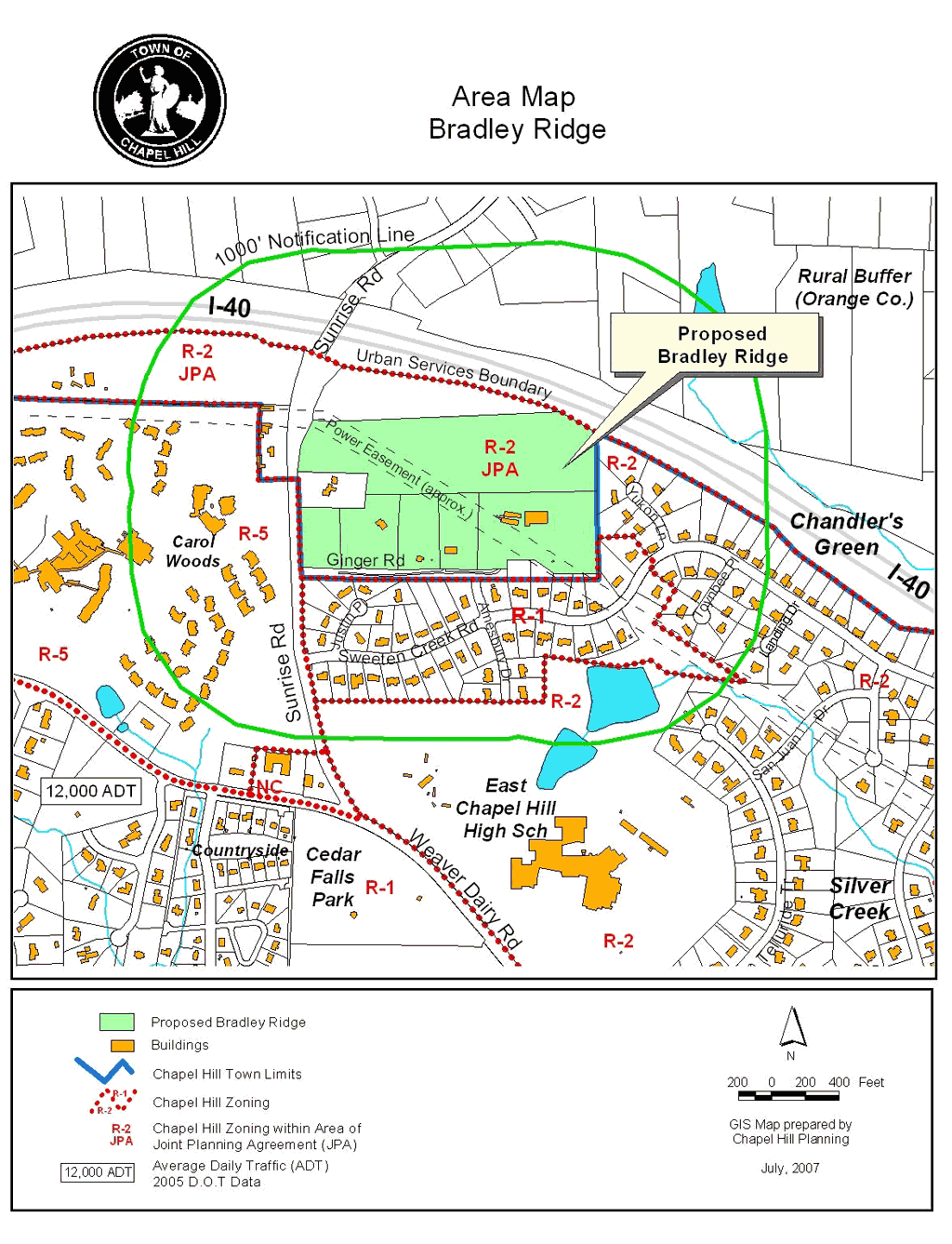
The 37.2 acre Bradley Ridge Cluster Subdivision is located on the east side of Sunrise Road, between Sweeten Creek Road and Interstate 40. A portion of the site is located in the Resource Conservation District. The site is located in the Residential-2 (R-2) zoning district, within the Urban Service Boundary and outside Town limits, in the Town’s extraterritorial planning jurisdiction. The property is located in Orange County and is identified as Parcel Identifier Numbers 9880-96-7441; 9890-06-0413; 9890-06-3350; 9890-06-5926; 9890-06-6312; and 9890-16-0437.
KEY ISSUE
Based on our evaluation and comments received from Advisory Boards, we believe at this point that the key issue concerning this proposed development is as follows:
Stormwater Management: At the December 18, 2007 Planning Board meeting, residents from Chandlers’ Green raised concerns regarding stormwater management. They believed that hydrological conditions associated with Basin I, and Lots 12 and 13, included d standing water, and therefore should not be built. The Planning Board noted that Town staff had made two field visits to the site for purposes of conducting a stream determination and had determined that the area in question could not be classified as an intermittent stream (no hydrologic connection) and therefore, the Resource Conservation District buffer requirements were not applicable. The Planning Board recommended that the staff reexamine the issues, taking into account data from the applicant and data presented by the residents, and adjust stipulations of approval if necessary.
Comment: Town staff met with the residents and the applicant on January 3, 2008 to further discuss the issues and review any additional data. Residents presented photos of the area taken after the recent rain event (December 30-31, 2007). Standing water was present. Staff does not dispute that there are wet areas on the project site; however, the area in question is isolated (not hydrologically connected) from the downstream perennial stream system.
Staff had transferred the locations of the soil borings conducted by GeoTechnologies for Habitat to the site plan and presented this information to the group. Groundwater had been encountered at only one of the boring locations (B-5), 3.5 feet below the surface. This boring is located approximately along the rear boundary of Lot 4. Groundwater was not encountered in the borings in the vicinity of the proposed Stormwater Basin 1 or Lots 12 and 13.
Staff clarified that these are not final plans and that detailed stormwater design calculations and plans are submitted as part of the Final Plan Zoning Compliance Permit. At that time, a detailed and comprehensive review of the design and supporting calculations will be conducted to ensure that they comply with the stormwater management requirements contained in the Town’s Land Use Management Ordinance, the Town Design Manual, and applicable State criteria.
We recommend no further revisions to the draft stipulations.
RECOMMENDATIONS
Planning Board: The Planning Board reviewed this proposal on December 18, 2007. The Board voted 6-0 to recommend that the Council approve the application with the adoption of the resolution attached to the December 4, 2007 Advisory Board memorandum, with the following changes:
Comment: The staff initially stipulated a payment-in-lieu for traffic calming devices. In response to a request by the Chandlers Green neighborhood, we recommend that the developer install the traffic calming device within Town limits on Amesbury Drive, before the project is connected to Amesbury Drive. This recommendation is included in Resolution A.
Comment: This project has frontage on the east side of Sunrise Road. The staff’s initial recommendation for construction of a sidewalk on the west side of Sunrise Road was in error. This has been corrected in Resolution A
Comment: The initial recommendation from the staff did not include a time limit for the use of the bus stop/shelter payment-in-lieu. Resolution A includes 5 year time limit as recommended by the Planning Board.
Comment: A proposed pedestrian path, to an open space area encumbered by a Resource Conservation District in the southeast corner of the site, was unintentionally included by the applicant on the site plan. Because this proposed open space is not required recreation area, and due to the environmentally sensitive Resource Conservation District, we recommend that the path to this area be deleted from the site plans. The stipulation associated with this path has been deleted from Resolution A. We believe the applicant will be presenting a revised site plan to the Council without this path.
Comment: Staff initially recommended prohibiting land disturbance in the RCD. The applicant believes that some disturbance in the RCD is appropriate in order to construct stomwater features. We concur and have included this recommendation in Resolution A.
Comment: The applicant noted that the proposed amount of impervious surface area did not adequately accommodate impervious surface areas on the residential lots. Resolution A includes this adjusted number.
Comment: This recommendation would prohibit all construction traffic from Chandlers Green and Ginger Road, prior to completion of all internal roadway and utility infrastructure. Although we concur with the intent of this recommendation, we believe that an exemption to this condition should be made for the sewer line construction proposed within the Chandlers Green neighborhood. A recommendation to this effect has been incorporated into Resolution A.
Comment: Resolution A includes a stipulation requiring fencing around the detention basin near the proposed tot lot.
Comment: Resolution A includes a stipulation requiring, subject to the approval of NCDOT, that the applicant install “No Parking” signs. The Resolution as required that the Homeowners Association be responsible for the maintenance of the signs until such time the area is annexed into Town limits.
The Summary of Planning Board Action is attached to this memorandum.
Parks and Recreation Commission: The Parks and Recreation Commission reviewed this subdivision proposal on December 19, 2007 and voted 10 to 0 to recommend that the Council approve the application with the adoption of the resolution attached to the December 4, 2007 Advisory Board memorandum with the following change:
Comment: Resolution A includes a stipulation requiring the construction of an informal, low impact pedestrian path between these two recreation areas.
A Summary of Parks and Recreation Commission Action is attached to this memorandum.
Transportation Board: The Transportation Board reviewed this subdivision proposal on January 10, 2008. The Summary of Transportation Board Action will be provided when available.
Bicycle and Pedestrian Advisory Board: The Bicycle and Pedestrian Advisory Board will meet on January 22, 2008. The Summary of Bicycle and Pedestrian Advisory Board will be provided when available.
Staff Preliminary Recommendation: Our preliminary recommendation is that the Council approve the Preliminary Plat application with the conditions listed in Resolution A.
Following Advisory Board review, the below changes have been incorporated into Resolution A:
Resolution A also includes the following adjusted stipulations, which were discussed in the Staff Report, but unintentionally absent from the resolution reviewed by the Advisory Boards:
Following tonight’s Public Hearing, we will prepare an evaluation of the evidence submitted in support of and in opposition to this application.
A copy of a matrix comparing the differences between the above recommendations is included at the end of this memorandum.
PROCESS
This is a Major Subdivision application requesting a Preliminary Plat approval. The Land Use Management Ordinance requires the Town Manager to conduct an evaluation of a Preliminary Plat application, to present a report to the Planning Board, and to present a report and recommendation to the Town Council. We have reviewed the application and evaluated it against Town standards. We have presented a report to the Planning Board and tonight we submit our report and preliminary recommendation to the Council.
Review of subdivision proposals differs from review of Special Use Permits in that the question of compliance with regulations and standards is the basis for approval or denial, rather than the four findings of fact listing in Section 4.5.2 of the Land Use Management Ordinance. However, the Council’s review and action on a subdivision is quasi-judicial, with sworn testimony and evidence entered into the record. Please see the attached summary of key differences between legislative and quasi-judicial zoning decisions, prepared by Mr. David Owens of the School of Government.
The standard of review and approval of a Preliminary Plat application involves comparing the application with the regulations and standards in the Land Use Management Ordinance. The review typically focuses on vehicular and pedestrian access and circulation, traffic impact, public improvements, lot standards, and recreation area.
Information regarding this application will be presented at tonight’s Public Hearing. The Land Use Management Ordinance directs that if, after consideration of the information, the Council decides that the application meets all the Land Use Management Ordinance requirements, the application must be approved. If the Council decides that the application does not meet all the Land Use Management Ordinance requirements, the application accordingly must be denied.
EVALUATION OF THE APPLICATION
We have evaluated the application regarding its compliance with the subdivision standards and regulations of the Town’s Land Use Management Ordinance. Based on our evaluation, our preliminary recommendation is that the application, as submitted, complies with the regulations and standards of the Land Use Management Ordinance and Design Manual, with the conditions in Resolution A.
The Council may find that the proposal meets the subdivision regulations and other pertinent Town regulations, or may find that the proposal does not meet the regulations. Please refer to the attached Staff Report for detail on compliance with subdivision regulations.
Tonight, the Council receives our attached evaluation, and also receives information submitted by the applicant and citizens. The applicant’s materials are included as attachments to this memorandum. All information that is submitted at the hearing will be included in the record.
SUMMARY
We have attached a resolution that includes standard conditions of approval as well as special conditions that we recommend. The key special conditions that we recommend are described in detail in the accompanying report. With these conditions, we believe that the Council could adopt a resolution to approve the application for a subdivision. The Manager’s recommendation incorporates input from all Town departments involved in review of the application.
BRADLEY RIDGE CLUSTER SUBDIVISION
Differences Between Recommendations
|
ISSUE |
Staff’s Preliminary |
Planning Board |
Parks & Rec. |
|
Traffic calming on Amesbury |
Yes, before opening to development |
* |
|
|
Sidewalk on westside Sunrise Rd |
No |
* |
|
|
Refund bus stop/shelter payment |
Yes, within 5 yrs of 30th certificate of occupancy |
* |
|
|
Delete pedestrian path to southeast |
Yes |
* |
|
|
Limit disturbance in RCD |
Yes, limit to upland zone |
* |
|
|
Prohibit construction traffic on Ginger and in Chandler Green until infrastructure complete |
Yes – except for sewer line extension within Chandlers Green |
Yes |
* |
|
Fencing around detention pond |
Yes |
* |
|
|
No parking signs |
Yes (to be maintained by the HOA until annexation) |
* |
|
|
Pedestrian path between rec. areas |
Yes |
* |
Yes |
ATTACHMENTS
ADDITIONAL INFORMATION (January 23, 2008)