TO: Mayor and Town Council
From: W. Calvin Horton, Town Manager
Subject: Public Hearing: Southern Community Park - Application for Special Use Permit
DATE: February 21, 2005
INTRODUCTION
We have received a request for approval of a Special Use Permit to construct the Town of Chapel Hill Southern Community Park, and associated improvements, located south of Southern Village on the west side of US 15-501 South. The proposal includes playing fields and courts, trails, picnic areas, a dog park, restrooms, 229 parking spaces, a recycling center and a site for a future community center. The 72-acre site is located in the Residential-1 and Residential Low Density-1 zoning districts and is identified as Chapel Hill Township Tax Map 128, Block A, Lot 31.
Tonight’s Public Hearing has been scheduled to receive evidence in support of and in opposition to approval of the application, and further to receive evidence which the Council may consider as the Council determines any appropriate requirements to include as conditions of approval.
|
This package of materials has been prepared for the Council’s consideration, and is organized as follows:
¨ Cover Memorandum: Introduces application, describes process for review, summarizes staff and advisory board comments, and offers recommendations for Council action.
¨ Staff Report: Offers a detailed description of the site and proposed development, and presents an evaluation of the application regarding its compliance with the standards and regulations of the Land Use Management Ordinance.
¨ Attachments: Includes a checklist of requirements for this development, resolutions of approval and denial, advisory board comments, and the applicant’s materials.
|
PROCESS
The Land Use Management Ordinance requires the Town Manager to conduct an evaluation of this Special Use Permit application, to present a report to the Planning Board, and to present a report and recommendation to the Town Council. We have reviewed the application and evaluated it against Town standards; we have presented a report to the Planning Board; and tonight we submit our report and preliminary recommendation to the Council.
The standard for review and approval of a Special Use Permit application involves consideration of four findings (description of the findings follows below). Evidence will be presented tonight. If, after consideration of the evidence, the Council decides that it can make each of the four findings, the Land Use Management Ordinance directs that the Special Use Permit shall then be approved. If the Council decides that the evidence does not support making one or more of the findings, then the application cannot be approved and, accordingly, should be denied by the Council.
BACKGROUND
In 1986, and 1989, Chapel Hill voters approved Parks bonds, portions of which were used to purchase the Southern Community Park property. In 1997, and 2001, Orange County voters approved Parks bonds that included funds designated for the Southern Community Park.
In July 2000, the Council appointed the Southern Community Park Conceptual Plan Committee. On March 25, 2002, the Town Council adopted the Report of the Southern Community Park Conceptual Plan Committee and directed the Town Manager to prepare an implementation plan. The Orange County Board of Commissioners adopted the park Concept Plan on March 5, 2003.
Concept Plan reviews of this application were conducted by the Community Design Commission on June 16, 2004, and by the Town Council on June 21, 2004.
DESCRIPTION OF THE APPLICATION
The applicant, the Town of Chapel Hill, is proposing to construct a community park with athletic fields and courts, a dog park, greenway trails, picnic and play areas. A recycling center is also proposed. The proposal also includes preserving a portion of the site for a future community center or recreation facility. Approximately 5,000 square feet of building area, 229 parking spaces, and approximately 10.8 acres of impervious surface are proposed.
Specific proposed park improvements include:
Athletics Fields
· 1 in-line hockey court
· 2 basketball courts
· 3 lighted full size athletic fields with bleachers
· 1 youth baseball field with bleachers
Playgrounds/Picnic Shelters/Dog Park/Meadows
· 1 playground
· 1 children’s water play area
· 2 picnic shelters
· 1 dog park with shelter with separate play areas for large and small dogs
· 1 meadow area (approximately 1 acre)
Pedestrian Paths/Bicycle Facilities
· 10’ wide asphalt greenway trail between Southern Village and Merritt Drive
· Preservation of a portion of an existing natural foot trail
· Internal pedestrian network including a walking path/gravel drive around the 3 athletic fields
· 4 bicycle racks
· 5’ sidewalk along the north side of Dogwood Acres Drive
Buildings (approximate square footage)
· 1 restroom facility (1,000 square feet)
· 1 maintenance building (3,000 square feet)
· 1 recycling center office (1,000 square feet)
Infrastructure
· 1 bus shelter
· 3 parking lots (229 spaces including 6 spaces at proposed maintenance building)
· 4 bio-retention / extended dry stormwater basins
· Refuse and recycling containers
· Off-site extension of water and sewer lines
· Deceleration and turn lanes on US 15-501 and Dogwood Acres Drive
· Traffic calming features on Dogwood Acres Drive and on the internal park road
Other
· Community recycling center (to be constructed and operated by Orange County Solid Waste)
· Reservation of a site for a future community center or other recreation facility (construction of this proposed future improvement will require the applicant to submit a separate Special Use Permit at a later date)
We have evaluated the application regarding its compliance with the standards and regulations of the Town’s Land Use Management Ordinance. Based on our evaluation, our preliminary recommendation is that the application as submitted, complies with the regulations and standards of the Land Use Management Ordinance and Design Manual with the conditions included in Resolution A.
Tonight the Council receives our attached evaluation, and also receives information submitted by the applicant and citizens. The applicant’s materials are included as attachments to this memorandum. All information that is submitted at the hearing will be placed into the record.
Based on the evidence that is submitted, the Council will consider whether or not it can make each of four required findings for the approval of a Special Use Permit.
The four findings are:
|
Special Use Permit – Required Findings of Fact
Finding #1: That the use or development is located, designed, and proposed to be operated so as to maintain or promote the public health, safety, and general welfare;
Finding #2: That the use or development would comply with all required regulations and standards of the Land Use Management Ordinance;
Finding #3: That the use or development is located, designed, and proposed to be operated so as to maintain or enhance the value of contiguous property, or that the use or development is a public necessity; and
Finding #4: That the use or development conforms with the general plans for the physical development of the Town as embodied in the Land Use Management Ordinance and in the Comprehensive Plan.
|
Following the Public Hearing, we will prepare an evaluation of the evidence submitted in support of and in opposition to this application.
KEY ISSUES
The phasing of proposed park improvements has been identified as the key issue.
Phasing of park improvement: Because of budgetary constraints, the construction of proposed park improvements will be phased over a period of time.
Comment: We are currently working on a phasing report for subsequent Council review.
SUMMARY
We have attached a resolution that includes standard conditions of approval as well as special conditions that we recommend for this application. With these conditions, our preliminary recommendation is that the Council could make the four findings necessary in order to approve the application. The Manager’s recommendation incorporates input from all Town departments involved in review of the application.
Following is a brief outline describing the next steps in the development review process, should the Council approve the Special Use Permit application for this site:
1. Applicant accepts and records a Special Use Permit, which incorporates the terms of the Council-adopted resolution.
2. Applicant submits detailed Final Plans and documentation, complying with Council stipulations. Information is reviewed by Town departments and the following agencies:
3. Community Design Commission reviews and approves building elevations and site lighting.
4. Upon demonstration of compliance with remaining Council stipulations, Town staff issues a Zoning Compliance Permit authorizing site work. Permit includes conditions specific to the development and requires pre-construction conferences with Town staff.
5. Inspections Department issues Building Permits and Certificates of Occupancy.
RECOMMENDATIONS
Recommendations are summarized below. Please see summaries of board actions and recommendations in the attachments.
Planning Board Recommendation: On February 1, 2005, the Planning Board voted 8 to 0 to recommend that the Council approve this application with the adoption of Resolution A. Please see the attached Summary of Planning Board Action.
Transportation Board Recommendation: On February 1, 2005, the Transportation Board voted 7 to 0 to approve this application with the adoption of Resolution B. Please see attached Summary of Transportation Board Action.
Resolution B includes the following stipulation:
Comment: The findings of the Traffic Impact Analysis do not support the installation of a traffic signal at the US 15-501/Dogwood Acres Drive intersection. A full warrant analysis was completed for the intersection of US 15-501 and Dogwood Acres Drive for the 2007 analysis year with site traffic added. Turning movement growth included ambient growth, background traffic growth, and site traffic impacts. No warrants were met, primarily due to the light daily approach volumes on eastbound Dogwood Acres Drive. Thus a traffic signal is not recommended at this intersection in 2007 due to the impacts of the Southern Community Park site.
Community Design Commission Recommendation: On January 20, 2005, the Community Design Commission voted 9 to 0 to recommend that the Council approve this application with the adoption of Resolution A. Please see attached Summary of Community Design Commission Action.
Bicycle and Pedestrian Advisory Board Recommendation: On January 25, 2005, the Bicycle and Pedestrian Advisory Board voted 10 to 0 to recommend that the Council approve this application with the adoption of Resolution A. Please see the attached Summary of Bicycle and Pedestrian Advisory Board Action.
Greenways Commission Recommendation: On January 26, 2005, the Greenways Commission voted 4 to 0 to approve the application with the adoption of Resolution C. Please see attached Summary of Parks and Recreation Action.
Resolution C includes the following stipulation:
Comment: The Town as applicant is proposing a minimum of 229 parking spaces. The proposal is based on our experience with other community recreation facilities and associated parking needs. We believe, based on past experience operating a public use facility and the anticipated need for additional parking associated with a future community center/recreational facility, the proposed number of parking spaces is reasonable.
This project must also comply with the parking lot shading requirements in accordance with Section 5.9.6 of the Land Use Management Ordinance. Section 5.9.6 requires vegetation within and adjacent to ground level parking areas which will, in the opinion of the Town Manager, be sufficient to achieve shading of at least 35 percent of the parking area surface.
Parks and Recreation Commission Recommendation: The Parks and Recreation Commission is scheduled to review this application on February 16, 2005. A copy of the Summary of Park and Recreation Commission Action will be provided when it is available.
Manager’s Preliminary Recommendation: Based on our evaluation of the application, our preliminary conclusion is that, with the stipulations in Resolution A, the application complies with the standards and regulations of the Land Use Management Ordinance.
Following tonight’s Public Hearing, we will prepare an evaluation of the evidence submitted in support of and in opposition to this application. If the Council makes the required findings for approval of a Special Use Permit, we recommend that the application be approved with the adoption of Resolution A.
Resolution B would approve the application as recommended by the Transportation Board.
Resolution C would approve the application as recommended by the Greenways Commission.
Resolution D would deny the application.
Southern Community Park - Special Use Permit
Differences Between Resolutions
|
ISSUES |
Resolution A (Approval) Manager’s Preliminary, Planning Board, Community Design Commission and Bicycle and Pedestrian Advisory Board Recommendations |
Resolution B (Approval)
Transportation Board Recommendation |
Resolution C (Approval)
Greenways Commission |
|
Traffic signal at Dogwood Acres Drive |
No |
Yes |
No |
|
Replace parking spaces with parking groves |
No |
No |
Yes |
ATTACHMENTS
1. Planning Staff Report (p. 9).
2. Project Fact Sheet Requirements (p. 24).
3. Resolution A (Manager’s Preliminary Recommendation Approving the Application) (p. 25).
4. Resolution B (Transportation Board Recommendation) (p. 33).
5. Resolution C (Greenway Commission Recommendation) (p. 34).
6. Resolution D (denial) (p. 35).
7. Community Design Commission Concept Plan Summary (p. 36).
8. Excerpt of Meeting Minutes, Council Concept Plan Review (p. 37).
9. Planning Board Action Summary Action (p. 39).
10. Transportation Board Action Summary Action (p. 40).
11. Community Design Commission Summary Action (p. 41).
12. Bicycle and Pedestrian Advisory Board Summary Action (p. 42).
13. Greenways Commission Summary Action (p. 43).
14. Statement of Justification (p. 44).
15. Project Fact Sheet (p. 48).
16. Traffic Impact Analysis Summary (p. 51).
17. Area Map (p. 63).
18. Reduced Plans (p. 64).
Additional Information From the Parks & Recreation Commission
STAFF REPORT
Subject: Public Hearing: Southern Community Park - Application for Special Use Permit
(File No. 128.A.31)
DATE: February 21, 2005
INTRODUCTION
We have received a request for a Special Use Permit for a public use facility (community park) and a public service facility (community recycling center) on a 70.54 acre site on the west side of US 15-501, between the Southern Village Park and Ride Lot and Merritt Drive. The applicant, the Town of Chapel Hill, is proposing to construct a community park with athletic fields and courts, a dog park, greenway trails, picnic and play areas. A recycling center is also proposed. The proposal also includes preserving a portion of the site for a future community center. Approximately 5,000 square feet of building area, 229 parking spaces, and approximately 10.8 acres of impervious surface is proposed.
Several off-site improvements, including the extension of water and sewer lines and roadway improvements along US 15-501 and Dogwood Acres Drive, are included with the proposal park.
The applicant is not requesting modifications of regulations as a part of this application.
BACKGROUND
In 1986, and 1989, Chapel Hill voters approved Parks bonds, portions of which were used to purchase the Southern Community Park property. In 1997, and 2001, Orange County voters approved Parks bonds that included funds designated for the Southern Community Park.
In July 2000, the Town Council appointed the Southern Community Park Conceptual Plan Committee. On March 25, 2002, the Town Council adopted the Report of the Southern Community Park Conceptual Plan Committee and directed the Town Manager to prepare an implementation plan. The Orange County Board of Commissioners adopted the park Concept Plan on March 5, 2003. On June 21, 2004, the Town Council reviewed a Concept Plan Proposal.
EVALUATION
The Town staff has reviewed this application for compliance with the standards of the Land Use Management Ordinance and the Design Manual and offers the following evaluation.
Existing Conditions
Location: The proposed 70.54 acre site is located approximately 1 mile south of US Highway 54, on the west side of US 15-501 South, between Scroggs Elementary School and Merritt Drive. Dogwood Acres Drive divides the 70.54 acre site into two parcels of 47.89 acres (north of Dogwood Acres Drive) and 22.65 acres (south of Dogwood Acres Drive).
The western property line of the 70 acre site (approximately 3,900 linear feet) is adjacent to 13 lots in the Dogwood Acres residential neighborhood. The northern property line (approximately 3,500 linear feet) traverses around the southern end of the Southern Village development, sharing a common property line with the Scroggs Elementary School, the school’s athletic field and the Town’s Park and Ride lot. Approximately 3,500 linear feet of the proposed site has frontage on US 15-501 South, a four-lane, median divided highway. Several residential buildings are located on the opposite side of the highway. The southern end of the property includes 230 feet of frontage on Merritt Drive, an unimproved public road. Approximately 1,000 feet of the site fronts Dogwood Acres Drive.
Except for a 2.47 acre portion of the site near the intersection of Merritt Drive and US 15-501 South, the site is located within the Chapel Hill town limits and the Urban Service Boundary. The entire site is located within the Watershed Protection District.
Existing Buildings: The site does not contain any buildings.
Vehicular Access: The property includes public street frontage along US 15-501 South, Dogwood Acres Drive and Merritt Drive. The US 15-501 South frontage includes access to an old timber road on the northern portion of the site. The site also adjoins a portion of the Southern Village Park and Ride Lot. The approved Special Use Permit for the Park and Ride lot anticipated providing vehicular access to the proposed park.
Pedestrian Access: A five-foot sidewalk exists along a portion of the site’s frontage on US 15-501 South, between Dogwood Acres Drive and Southern Village. The interior of the site also includes an informal network of pedestrian foot paths with access points onto Merritt Drive, Dogwood Acres Drive (two access points), the southern end of the Southern Village Greenway and into the Town’s Park and Ride Lot.
Utilities: An overhead 3-phase electric utility line runs along US 15-501. Another overhead single phase utility line runs across (east to west) the 22 acres portion of the site south of Dogwood Acres Drive. The site does not include water, sewer, or natural gas infrastructure. The closest water lines are located approximately 150 feet and 500 feet away respectively, in Dogwood Acres and Southern Village. The closest sewer main is approximately 100 feet away in Southern Village.
Bus Stops, Routes: The Southern Village Park and Ride Lot is located along the site’s north property line.
Topography: The site generally contains slopes between 0 and 10 percent with steeper slopes between 10 and 25 percent, along several drainage corridors. Several high points on the property exist along the US 15-501 South portion of the site. The low point occurs along the west property line where three drainage features cross the property line.
Drainage: The property generally drains from east to west and includes three major drainage basins. The three drainage basins are sub-basins to the Morgan Creek drainage basin. A portion of the northwest corner of the site drains onto the Southern Village development.
The two northern-most drainage basins include perennial and intermittent streams. A perennial stream classification has been designated for the third basin located south of Dogwood Acres Drive. This drainage basin also includes a wetland area of approximately 1,077 square feet. Approximately 12.65 acres of the 70.54 acre site is Resource Conservation District.
Vegetative Cover: The site contains two distinct forest vegetation associations (pine and hardwoods). Two major areas of the site are covered exclusively with pine. One area of pines occupies the northeast corner of the site and extends along the edge of US 15-501. The second area, located in the central west half of the site is interrupted by Dogwood Acres Drive and an overhead power line. The large stand of pines is very young with trees ranging from 4 to 5 inch caliper and 30 to 35 feet in height. A majority of the pine forest suffered extensive damage from an ice storm in December 2002.
The remainder of the northern half of the site and a portion of the area directly south of Dogwood Acres Drive is covered with a mix of deciduous and coniferous trees. Unlike the area of pines, there is a good deal of understory vegetation, especially along drainage ways.
Several cleared areas (fields) are also present and contain mainly pioneer grasses and shrubs.
The applicant, the Town of Chapel Hill, is proposing to construct a community park with athletic fields and courts, a dog park, greenway trails, picnic and play areas. A recycling center is also proposed. The proposal also includes preserving a portion of the site for a future community center or recreation facility. Approximately 5,000 square feet of building area, 229 parking spaces, and approximately 10.8 acres of impervious surface are proposed.
Specific proposed park improvements include:
Athletics Fields
· 1 in-line hockey court
· 2 basketball courts (including 10’ high vinyl coated chain link fence)
· 3 lighted full size athletic fields with bleachers (including 8-10’ high vinyl coated chain link
fence)
· 1 youth baseball field with bleachers
Playgrounds/Picnic Shelters/Dog Park/Meadows
· 1 playground
· 1 children’s water play area
· 2 picnic shelters
· 1 dog park with shelter and separate areas for large and small dogs (including 5’ high vinyl coated chain link fence)
· 1 meadow area (approximately 1 acres)
Pedestrian Paths/Bicycle Facilities
· 10’ wide asphalt greenway trail between Southern Village and Merritt Drive
· Preservation of a portion of an existing natural foot trail
· Internal pedestrian network including a walking path/gravel drive around the 3 athletic fields
· 4 bicycle racks
· 5’ sidewalk along the north side of Dogwood Acres Drive
Buildings (approximate square footage)
· 1 restroom facility (1,000 square feet)
· 1 maintenance building (3,000 square feet)
· 1 recycling center office (1,000 square feet)
Infrastructure
· 1 bus shelter
· 3 parking lots (229 spaces including 6 spaces at proposed maintenance building)
· 4 bio-retention / extended dry stormwater basins
· Refuse and recycling containers
· Off-site extension of water and sewer lines
· Deceleration and turn lanes on US 15-501 and Dogwood Acres Drive
· Traffic calming features on Dogwood Acres Drive and on the internal park road
Other
· Community recycling center (to be constructed and operated by Orange County Solid Waste)
· Reservation of a site for a future community center or other recreation facility (construction of this proposed future improvement will require the applicant to submit a separate Special Use Permit at a later date)
Concept Plan / Special Use Permit Application Comparison
The Special Use Permit being reviewed tonight includes several changes from the Concept Plan presented to the Community Design Commission on June 16, 2004 and the plan presented to the Town Council on June 21, 2004. Some of the differences include:
a) Adding parking spaces to the northern parking lot;
b) Deleting proposal to add parking spaces to the Park and Ride lot;
c) Moving athletics fields to provide greater buffer along US 15-501 South;
d) Adding parking spaces to southern parking lot (south of Dogwood Acres Drive);
e) Adding two pedestrian crossings on Dogwood Acres Drive; and
f) Adding a sidewalk segment on the south side of Dogwood Acres Drive.
A copy of Community Design Commission Summary Comments from the June 16, 2004 meeting and Council minutes from the June 21, 2004 meeting are attached to this report.
Ordinance Requirements
Zoning: This property is zoned Residential-1 (R-1) and Residential Low Density-1 (R-LD1). Adjacent properties are zoned Residential-5-Conditional (Southern Village), Residential-1 a (Dogwood Acres) and Residential Low Density-5 (R-LD5) and Residential Low Density-1 (R-DL1). Except for Southern Village, the adjoining properties are located outside the Town’s zoning jurisdiction and Urban Service Area.
Some of the permitted uses in the R-1 and R-LD1 zoning districts include a public use facility, place of worship, non-profit recreation facility and an elementary or secondary school. A public service facility is permitted with a Special Use Permit.
Dimensional Standards: The proposal is subject to the dimensional standards outlined in the Dimensional Matrix (Table 3.8-1) of the Land Use Management Ordinance for the Residential-1 and Residential Low Density-1 zoning districts.
The Town as applicant is proposing to construct approximately 5,000 square feet of floor area. The maximum floor area permitted on this 70.54 acre site is 277,573 square feet.
The proposal complies with all of the dimensional requirements for the R-1 and RLD-1 zoning districts.
Entranceway Corridor: A 250 foot wide corridor, running along the site’s US 15-501 frontage, is defined as an Entranceway Corridor in the Town’s 1989 Entranceway Design Guidelines, a component of the Town’s Comprehensive Plan. Please refer to the Buffers and Landscape Section below and the attached Statement of Justification Finding Four, for additional information regarding the Entranceway Corridor. We believe the proposal meets the spirit of the entranceway objectives, with the proposed 30 to 100 foot landscape buffers along the highway, while achieving other community recreational objectives.
Access and Circulation
Vehicular Access: Proposed vehicular access is to be accommodated through three entry/exit points. A full access connection to Main Street in Southern Village via the Town Park and Ride Lot, a full access driveway to Dogwood Acres Drive, and a right-turn in/right-turn out to US 15-501 South is proposed .
The Town as applicant is proposing to construct a southbound deceleration lane on US 15-501 at the proposed northern connection to the park. Submitted plans also include separate right-turn and left-turn lanes on Dogwood Acres Drive at the US 15-501 intersection. Traffic calming measures are also proposed along Dogwood Acres Drive.
The proposed park includes an internal street between the Park and Ride Lot and the proposed entry/exit on US 15-501. The Town is proposing to dedicate and maintain this roadway as public right-of-way. As currently proposed, this internal street includes a traffic calming device. We recommend that prior to the issuance of a Zoning Compliance Permit, the Town Manager review and approve the design and construction standards for this proposed public street, including any proposed traffic calming measures.
Vehicular Parking: The Special Use Permit application is for a public use facility (community park) and a public service facility (community recycling center). The Land Use Management Ordinance specifies minimum parking requirements for a public use facility at 1 parking space for every 350 square feet of floor area. Based on the proposed 4,000 square feet of floor area (public use facility) the minimum number of on-site parking spaces required is 13. The Land Use Management Ordinance does not specify minimum parking requirements for a public service facility (1,000 square foot recycling center building).
The proposal includes 229 parking spaces. The main on-site parking lot, located in the north portion of the site near the future recycling center, is proposed to have 158 parking spaces. A second, 65 space parking lot is proposed near the youth baseball field, on the south side of Dogwood Acres Drive. A 6 space parking area is proposed near the maintenance building.
We believe, based on the Town’s past experience in operating public use facilities and the anticipated need for additional parking associated with a future community center/recreational facility, that the proposed 229 on-site parking spaces is reasonable.
Based on field observations of the Park and Ride Lot, the Town anticipates that parking for an additional 100 vehicles can be accommodated in the Town Park and Ride Lot when it is not in use. The applicant anticipates that the 158 parking spaces in the north lot and the available overflow parking spaces in the Town Park and Ride Lot will accommodate the parking needs for the future Community Center.
Bicycle Access/Parking: The minimum number of required bicycle parking spaces is generally calculated as 10 percent of the minimum number of required parking spaces. In this particular case, as described above in the section on Vehicular Parking, the minimum number of parking spaces (13) is not adequate to serve the needs of the proposed development. Therefore the Town as applicant is proposing 229 parking spaces.
We recommend that the required minimum bicycle parking spaces be calculated as 10 percent of the applicant’s proposed 229 parking spaces (30 bicycle parking spaces). The applicant is proposing four bicycle racks including a total of 40 bicycle parking spaces. We recommend that the applicant provide a minimum of 40 bicycle parking spaces (8 Class I and 32 Class II).
Pedestrian Circulation: A five-foot sidewalk exists along a portion of the site’s frontage on US 15-501 South, between Dogwood Acres Drive and Southern Village. The interior of the site also includes an informal network of pedestrian foot paths with access points onto Merritt Drive, Dogwood Acres Drive (two access points), the southern end of the Southern Village Greenway and into the Town’s Park and Ride Lot.
Sidewalks: The Town as applicant is proposing to construct a five-foot sidewalk along the site’s frontage on the north side of Dogwood Acres Drive. The Town is also proposing to construct a five-foot sidewalk between the proposed Dogwood Acres Drive sidewalk and the southern end of the existing sidewalk on US 15-501 South.
We recommend that the Dogwood Acres Drive sidewalk be located behind the roadside ditch or constructed as a meandering sidewalk. As part of this proposal we also recommend that the Town construct a five-foot wide sidewalk between the north end of the US 15-501 South sidewalk and the existing sidewalk in Southern Village, at the intersection of Main St and US 15-501.
Greenway, paths, and trails: The proposed plan includes an internal pedestrian network connecting playing fields, parking areas, building and other park amenities. The proposed site plan includes an extension of the Southern Village greenway, and a system of pedestrian paths and natural trails thought the development.
The proposed greenway trail will connect to the southern end of the greenway trail in Southern Village and the south end of an existing trail near the Scroggs Elementary School athletic field. The proposed greenway trail will extend north and south through the entire length of the park, cross Dogwood Acres Drive and end on US 15-501 near Merritt Drive.
Where feasible, the Town as applicant intends to preserve the existing informal pedestrian foot path currently use by area residents.
We recommend that prior to the issuance of a Zoning Compliance Permit, the Town Manager approve design and detailed construction plans for the proposed greenway, pedestrian paths, and natural trails.
Bus Stop, Routes: A bus stop is proposed within the park, next to the future recycling center.
The proposed plans also include constructing an internal street between the Southern Village Park and Ride Lot and the north park entrance/exit on US 15-501 South. We believe that this proposed internal street, with direct access into the Southern Village Park and Ride Lot from US 15-501 could function as the primary bus routing entrance for the park/ride lot.
Traffic Impact Analysis: The Traffic Impact Analysis was prepared by a Town consultant in accordance with the Town’s Traffic Impact Analysis guidelines. The purpose of the analysis is to determine the impact of the proposed development to the surrounding transportation system.
Traffic flow conditions were analyzed at the following intersections:
1. US 15-501 and Main Street
2. US 15-501 and Future Site Driveway
3. US 15-501 and Dogwood Acres Drive
4. Smith Level Road and Dogwood Acres Drive
Traffic volumes from other existing and proposed developments (Southern Village and Chancellor’s View) in the immediate area were included in the analysis of future conditions.
The Traffic Impact Analysis makes the assumption that the proposed development will be completed and operational by 2007. The traffic impact analysis was based on the anticipated 2007 build out. According to the analysis, the proposed development (2007 build-out) would generate approximately 328 daily total vehicle trips.
Because of budgetary constraints, the construction of proposed park improvements may be phased over a period of time beyond the anticipated 2007 build out. We are currently working on a phasing report for subsequent Council review.
Traffic Impact Analysis Findings- Recommendation: Existing and future design capacity analyses did not indicate a need for additional improvements to maintain adequate traffic operations on study area facilities. The results of the short-term design year intersection capacity analysis show that no improvements are required to maintain adequate Level of Service and vehicular delay for any of the Peak periods.
However, there are some safety considerations and operational efficiency considerations that need to be addressed due to the development impact of the proposed park. The Traffic Impact Analysis recommends the following improvements:
1. Construct a deceleration lane for site traffic entering the park off of US 15-501 at the northern entrance.
2. Provide additional signage indicating access points to the park.
3. Prohibit on street parking along Dogwood Acres Drive within the park property.
4. Provide pedestrian crossing signs and street lighting for trails crossing Dogwood Acres Drive.
5. Provide active traffic calming measures on Dogwood Acres Drive.
6. Reduce speed limits on Dogwood Acres Drive to 25 mph within park limits.
7. Set posted speed limit on park main access driveway at 15 mph.
8. Improve internal driveway circulation.
We support the findings of the Traffic Impact Analysis and the recommended improvements. The applicant has agreed to the above recommendations.
Roadway Improvements
US 15-501: The Town as applicant is also proposing to construct dedicated right and left turn lanes on Dogwood Acres Drive at the US 15-501 South intersection. We recommend that the Town construct a right-turn deceleration lane on US 15-501 at the northern proposed park entrance. The design of the deceleration lane must be reviewed and approved by the Town Manager and the North Carolina Department of Transportation prior to the issuance of a Zoning Compliance Permit.
Dogwood Acres Drive: We recommend that the Town as applicant install separate right-turn and left-turn lanes on Dogwood Acres Drive at the US 15-501 intersection. We recommend that the Town also construct traffic calming measures along the park section of Dogwood Acres Drive. The type, number, location, design and construction of traffic calming measures must be reviewed and approved prior to the issuance of a Zoning Compliance Permit.
We recommend that the Council to prohibit on-street parking along the park’s frontage on Dogwood Acres Drive. If a parking prohibition is approved by the Council, prior to the opening of the park, we recommend that the installation of no-parking signs according to Town standards.
We recommend that prior to the issuance of a Zoning Compliance Permit the Council approve 25 miles per hour speed limit along that portion of Dogwood Acres Drive within park limits. We also recommend that the Town Manager review and approve a traffic calming plan for the portion of Dogwood Acres Drive within park limits.
At this time Dogwood Acres Drive is maintained by the North Carolina Department of Transportation. The applicant and NCDOT are currently discussing transferring maintenance of that portion of Dogwood Acres Drive adjacent to the park site to the Town of Chapel Hill. If the Town takes over maintenance of this portion of the street prior to submission of a Final Plan application, the authorization to reduce the speed limit, install no parking signs and construct other roadway improvements shall be reviewed and approved by the Town. Otherwise it will be necessary for the Town to obtain approval from NCDOT for the required improvements and speed limit, prior to the issuance of a Zoning Compliance Permit.
Other Improvements: We recommend that the driver sight distance at all street intersections and driveways meet or exceed the Town’s standards for driver sight distance. Prior to the issuance of a Zoning Compliance Permit, sight distance triangle must be approved by the Town Manager and where applicable NCDOT.
Prior to the issuance of a Zoning Compliance Permit, the Town Manager shall approve a street sign, on-street parking, and pavement marking plan. The signs and pavement markings shall be installed prior to the issuance of a Certificate of Occupancy.
Landscaping and Architectural Issues
Buffers and Landscaping: The table below outlines the minimum landscape buffer requirements for the site and the buffers proposed by the Town as applicant.
|
Landscape Buffers |
||
|
Location |
Ordinance Requirement |
Proposal |
|
US 15-501 South |
30’ wide Type D |
Variable (30’-100’ wide Type D)
Proposed buffer location is outside the US 15-501 utility easement |
|
Dogwood Acres Drive |
30’ wide Type D |
Variable (25’-100’ wide Type D)
Alternate buffer proposed for areas less than 30’ in width |
|
Merritt Drive |
30’ wide Type D |
100’ wide Type D |
|
West Property Line (Dogwood Acres) |
20’ wide Type C |
Variable
60’-100’ wide Type C
|
|
North Property Line (Southern Village & Park and Ride Lot ) |
20’ wide Type C |
Variable (10’-100 wide Type C)
Alternate buffer proposed for areas less than 30’ in width |
Alternate Buffers: The Town as applicant is proposing alternate landscape buffers in two locations. The first proposal is located where an existing pedestrian path from Scroggs Elementary School connects to the Park and Ride Lot. The second proposed alternate buffer is along the north side of Dogwood Acres Drive near the intersection of US 15-501 South. We believe these alternate buffer requests are appropriate.
We recommend that an alternate buffer plan be approved by the Community Design Commission prior to the issuance of a Zoning Compliance Permit.
We recommend that a detailed Landscape Protection Plan be approved by the Town Manager prior to issuance of a Zoning Compliance Permit. This plan must include a detail of protective fencing and construction parking and materials staging/storage areas. This plan must also indicate which labeled trees are proposed to be removed and where tree protection fencing will be installed.
In order to improve the screening potential of existing vegetation in those areas where existing vegetation is being retained, we recommend that the landscape planting plan include supplemental evergreen shrub plantings. We recommend that detailed landscape plans (including buffers), landscape maintenance plans, and parking lot shading requirements be approved by the Town Manager prior to issuance of a Zoning Compliance Permit. The landscape plan shall indicate the size, type, and location of all proposed plantings.
We recommend that prior to the issuance of a Zoning Compliance Permit, the Town Manager approve a planting plan for the bio-retention facility, proposed between the Park and Ride Lot and the future community recycling facility.
We also recommend that all parking areas be screened from view in accordance with the provisions of Section 5.6 of the Land Use Management Ordinance. The screening plans shall be approved by the Town Manager prior to the issuance of a Zoning Compliance Permit.
Building Elevation and Lighting: We recommend that detailed building elevations, including all proposed fencing, and lighting plans be approved by the Community Design Commission prior to the issuance of a Zoning Compliance Permit. The Land Use Management Ordinance includes specific regulations regarding the lighting of Sports Fields (Section 5.11.3).
Watershed Protection District The site is located inside the Watershed Protection District and is subject to impervious surface limits specified in Article 3.6.4 of the Land Use Management Ordinance. The Land Use Management Ordinance requires proposed development to comply with either a Low Density Option (24% impervious surface limit) or a High Density Option (50% impervious surface limit). The applicant is proposing to comply with the Low Density Option.
The Town as applicant has proposed 10.8 acres of impervious surface.
Floodplain: The site does not lie within the Federal Emergency Management Agency (FEMA) 100-year floodplain.
Resource Conservation District: The property includes three separate drainage basins each eventually draining into Morgan Creek. The two northern most drainage basins include perennial and intermittent streams. A perennial stream classification has been designated for the southern basin. Approximately 12.65 acres of the site is Resource Conservation District. Of the 12.65 acres, approximately 6% (0.85 acres) is proposed to be disturbed. Proposed land disturbance in the Resource Conservation District includes a portion of the sewer line/greenway construction, walking trails, and boardwalk. Disturbance within the Resource Conservation District for these uses is permitted.
We recommend that prior to the issuance of a Zoning Compliance Permit the final plans identify Resource Conservation District associated with the proposed off-site sewer line improvements on the Southern Village site.
We believe that all activity proposed in the Resource Conservation District, associated with this application, complies with Land Use Management Ordinance provisions.
Wetlands: The submitted application identifies 1,077 square feet of wetlands in the southern drainage basin. The development does not propose land disturbance in the wetlands. We recommend that prior to the issuance of a Zoning Compliance Permit the final plans identify the location of State or federally regulated wetlands on the site. We recommend that all wetlands associated with the proposed off-site improvements (sewer line in Southern Village) also be identified. We recommend that any proposed disturbance of wetlands demonstrate compliance with applicable State and federal regulations.
Significant Tree Stands: The submitted application identified significant tree stands on Site Analysis Sheet SA-2. We believe that a majority of the significant tree stands, located in the western and southern portion of the site, will be maintained.
Stormwater Management: Except for stormwater from a section of the proposed greenway at the southern section of the park, the Town is proposing that all stormwater from the site will be piped to one of four bio-retention basins on the site. The stormwater plans also proposing to treat stormwater run-off from US 15-501.
We recommend that, prior to the issuance of a Zoning Compliance Permit, a Stormwater Management Plan is submitted for review and approval by the Town Manager. We recommend that the plan be based on the 1-year, 2-year, and 25-year frequency, 24-hour duration storms, where the post-development stormwater run-off rate shall not exceed the pre-development rate and the post-development stormwater runoff volume shall not exceed the pre-development volume for the local 2-year frequency, 24-hour duration storm event. Engineered stormwater facilities must also remove 85% of total suspended solids and treat the first inch of precipitation utilizing NC Division of Water Quality design standards. We recommend that the approved Stormwater Management Plan include the stormwater features as proposed on the submitted grading and drainage plan sheets.
We recommend that the Town Manager approve all off-site construction and stormwater easements. We also recommend that recorded copies of the easement be submitted prior to the issuance of a Zoning Compliance Permit.
Erosion Control: We recommend that a soil erosion and sedimentation control plan (including provisions for maintenance of facilities and modification of the plan if necessary), be reviewed and approved by North Carolina Department of Environment and Natural Resources. We also recommend that the plan is reviewed by the Orange County Erosion Control Officer, and that a copy of comments associated with the review be provided to the Town Manager prior to the issuance of a Zoning Compliance Permit.
Utilities and Service Issues
Electric Service: An existing 3-phase overhead electric line, located within a 30-foot wide utility easement, runs along the frontage of the site on US 15-501 South. The Town as applicant intends to tie into this utility service line in order to provide electrical power to portions of the site located north of Dogwood Acres Drive. A second overhead single-phase electric line, located within a 30-foot Progress Energy utility easement, runs east-west through the south portion of the site. The applicant intends to tie into this utility service line in order to provide electrical power to the portion of the site south of Dogwood Acres Drive.
Except for the portion of the existing electric utility line, that runs along US 15-501 South, the Town as applicant intends to install the existing single-phase overheard utility line south of Dogwood Acres Drive, and all proposed utility lines underground. We recommend that where practical, installation of underground utility lines shall not be permitted within the tree protection areas as shown on the submitted site plans.
Sewer Service: Sewer service must be extended to this proposed development site. The Town as applicant is proposing to install approximately 2,000 feet of sewer line between an existing man-hole on the adjacent Southern Village site, and a proposed restroom near the three main playing fields. Most of this proposed sewer line, except for approximately 200 feet near Southern Village and 200 feet near the restrooms, will be installed adjacent to a portion of the proposed 10-foot wide greenway trail.
Approximately 800 feet of this new sewer line (8-inch public main) will be installed within an existing or proposed 30-foot wide public utility easement. The applicant is proposing to dedicate a utility easement for that portion of the 8-inch line not located in an existing easement. The Town is also proposing to dedicate a 30-foot wide utility easement, between the proposed 8-inch public line and the Dogwood Acres neighborhood, for a possible future sewer line extension.
Most of the proposed 8-inch line (660 feet) is located within the Resource Conservation District. The remaining portion of the new sewer (approximately 1,200 feet) will be a 6-inch private lateral.
We anticipate that construction associated with the off-site sewer construction, on the Southern Village site, will require clearing a utility corridor between 20 to 30 feet in width. Clearing associated with the construction of the sewer and greenway path is anticipated to be between 40 and 80 feet in width. Because neither the Town nor OWASA intends to extend a public sewer line to the Dogwood Acres neighborhood as part of this project, the proposed sewer easement to this neighborhood will not be cleared at this time.
Water Service: Water service must be extended to this proposed development site. The Town as applicant is proposing to install approximately 3,750 feet of a 12-inch water public line between an existing line at the southern entrance to Southern Village, on US 15-501 South, and an existing line on Dogwood Acres Drive. Approximately 2,500 feet of water line is proposed along US 15-501 South; 1,250 of water line is proposed along Dogwood Acres Drive between US 15-501 and Merritt Drive. This proposed public water line extension will be installed within existing, public right-of-way and will include five fire hydrants.
Proposed service water line extensions into the development, from this 12-inch public water line, include water service to the restroom facility, the maintenance building, dog park, youth baseball field (water fountain), and irrigation system for the three athletic fields.
Except for that portion of the proposed 12-inch water line along Dogwood Acres Drive, between the proposed development site and Merritt Drive, we believe that the proposed installation of the public water line and internal service water will occur in areas already cleared (public right-of-way) or in area designated as outside the proposed tree protection fencing. In order to minimize the amount of clearing required to install the proposed 12-inch water line along Dogwood Acres Drive, between the proposed development and Merritt Drive, we recommend that, prior to the submission of a Zoning Compliance Permit, the applicant submit a tree protection and clearing plan for this proposed improvement.
Other Utilities: We recommend that the Council approval of this Special Use Permit include authorization for the installation of all utilities, including the proposed off-site improvements. We recommend that prior to the issuance of a Zoning Compliance, that the final plan submission include easement documents and record a plat for the extension of the proposed 8-inch sewer line. We also recommend that the easement and plat dedication include the easement extension to the Dogwood Acres neighborhood. We recommend that the Town Manager review and approve all utility easement documents and plats prior to recordation.
We also recommend that the limits of land disturbance and tree protection fencing for all off-site improvements, including land disturbance within existing or proposed right-of-way and utility easements, be shown on a Landscape Protection Plan, to be approved by the Town Manager prior to issuance of a Zoning Compliance Permit.
We recommend that detailed utility plans be reviewed and approved by OWASA, Progress Energy Public Service Company, BellSouth, Time Warner Cable and the Town Manager prior to issuance of a Zoning Compliance Permit. We have included these standard stipulations in Resolution A. The applicant is not proposing to extend natural gas service to this proposal development.
Refuse Management: The proposed plan for refuse management includes separate refuse and recycling containers. We recommend that prior to the issuance of a Zoning Compliance Permit, the Town Manager review and approve a Solid Waste Management Plan, including provisions for refuse collection and recycling. We also recommend that the plan provide for managing and minimizing construction debris and demolition waste.
Fire Safety: We have included our standard stipulation requiring that a fire flow report sealed by a professional engineer, be submitted for review and approval by the Town Manager prior to the issuance of a Zoning Compliance Permit. We also recommend that, prior to the issuance of a Zoning Compliance Permit, the Engineering Department review and approve all parking lot turning radii to ensure that Fire Apparatus can maneuver within the parking lots in case of a vehicle fire.
Miscellaneous Issues
Construction Management Plan: We recommend that a Construction Management Plan, indicating how construction vehicle traffic will be managed, be approved by the Town Manager prior to the issuance of a Zoning Compliance Permit.
Traffic and Pedestrian Control Plan: We recommend that a Traffic Management Plan for movement of motorized and non-motorized vehicles on any public streets (maintained and operated by the Town or the NCDOT) that will be disrupted during construction, including detour information and a Pedestrian Management Plan indicating how pedestrian movements on or adjacent to public rights-of-way will be safely maintained, be reviewed and approved by the Town Manager prior to the issuance of a Zoning Compliance Permit.
Land Use Plan
The Land Use Plan, a component of the Comprehensive Plan, adopted by the Council on May 8, 2000, identifies this area as Park/Open Space and Rural Residential
Special Use Permit Findings
For approval of a Special Use Permit, the Council must make the following findings, as set forth in Section 4.5.2 of the Land Use Management Ordinance:
1. That the use or development is located, designed, and proposed to be operated so as to maintain or promote the public health, safety, and general welfare;
2. That the use or development complies with all required regulations and standards the Land Use Management Ordinance;
3. That the use or development is located, designed, and proposed to be operated so as to maintain or enhance the value of contiguous property, or that the use or development is a public necessity; and
4. That the use or development conforms with the general plans for the physical development of the Town as embodied in the Land Use Management Ordinance and in the Comprehensive Plan.
Upon review of the application and information that has been submitted to date, our preliminary recommendation is that finding 1, 2, and 4 can be made and that the Council can find that the development is a public necessity.
CONCLUSION
Based on information available at this stage of the application review process, we believe that the proposal, with the conditions and modifications in Resolution A, meets the requirements of the applicable sections of the Land Use Management Ordinance and Design Manual, and that the proposal conforms with the Comprehensive Plan.
Resolutions A would approve the application with conditions.
Resolution B would approve the application as recommended by the Transportation Board.
Resolution C would approve the application as recommended by the Greenways Commission.
Resolution D would deny the application.
Project Fact Sheet Requirements
Check List of Regulations and Standards
Southern Community Park |
Compliance |
Non-Compliance |
|
Use Permitted |
Ö |
|
|
Min. Gross Land Area |
Ö |
|
|
Min. Lot Size |
Ö |
|
|
Min. Lot Width |
Ö |
|
|
Max. Floor Area |
Ö |
|
|
Impervious Surface Limits |
Ö |
|
|
Landscape Buffer Requirements |
Ö (with alternate buffer approval from Community Design Commission |
|
|
Treatment of Stormwater Quality, Volume, and Rate |
Ö |
|
|
Min. # Parking Spaces |
Ö |
|
|
Max. # Dwelling Units |
N/A |
|
|
Min. Street Setback |
Ö |
|
|
Min. Interior Setback |
Ö |
|
|
Min. Solar Setback |
Ö |
|
|
Max. Height Limit |
Ö |
|
N/A = Not Applicable Prepared: January 13, 2005
RESOLUTION A
(Approving the Special Use Permit)
A RESOLUTION APPROVING AN APPLICATION FOR A SPECIAL USE PERMIT FOR THE TOWN OF CHAPEL HILL, SOUTHERN COMMUNITY PARK
NOW, THEREFORE, BE IT RESOLVED by the Council of the Town of Chapel Hill that the Council finds that the Special Use Permit application proposed by the Town of Chapel Hill on property identified as Chapel Hill Township Tax Maps 7.126.A.4J and 128.A.2E, 31, 31A (PIN 9777937966, 9777911333, 977937092 and 977926176), if developed according to the site plans dated January 6, 2005 and the conditions listed below:
BE IT FURTHER RESOLVED that the Council hereby approves the application for a Special Use Permit for the Town of Chapel Hill, Southern Community Park in accordance with the plans listed above and with the conditions listed below:
Stipulations Specific to the Development
1. That construction begins by (two years from approval date) and be completed (ten years from approval date).
2. Land Use Intensity: This Special Use Permit authorizes a public use facility (community park) and public service facility (community recycling center) with land use intensity requirements and dimensional standards as specified below:
|
Land Use Intensity |
|
|
Net Land Area |
70.54 acres |
|
Total # of Buildings |
3 (not including picnic shelters) |
|
Permitted Floor Area |
5,000 sq ft |
|
Impervious Surface Area |
10.8 acres (approximately) |
|
Maximum # of Parking Spaces |
229 |
|
Minimum # of Bicycle Spaces |
40 |
Stipulations Related to Access and Circulation
3. US 15-501 South Improvements: That the applicant shall construct the following roadway improvements on US 15-501 South:
a) A southbound deceleration lane at the proposed northern connection to the park.
b) A five-foot wide sidewalk along US 15-501 South between Southern Village and the north end of the US 15-501 South sidewalk.
c) A five-foot wide sidewalk along US 15-501 between Dogwood Acres Drive and the south end of the US 15-501 sidewalk.
The design and construction of the improvements must be approved by the Town Manager and the North Carolina Department of Transportation prior to the issuance of a Zoning Compliance Permit.
4. Encroachment Permit: Prior to the issuance of a Zoning Compliance Permit, the applicant shall secure and provide an encroachment agreement from the North Carolina Department of Transportation for all work within the State maintained roadway right-of-way.
5. Dogwood Acres Drive Improvements: That the applicant shall construct the following roadway improvements on Dogwood Acres Drive:
a. Separate right-turn and left turn lanes at the US 15-501 South intersection.
b. Traffic-calming measures and pedestrian crossings.
c. Five-foot wide sidewalk along the north side of the roadway frontage.
d. Five-foot wide sidewalk on the south side of the roadway frontage, between US 15-501 South and the parking lot near the youth baseball field.
The design and construction of the improvements must be approved by the Town Manager and if applicable the North Carolina Department of Transportation, prior to the issuance of a Zoning Compliance Permit.
6. Dogwood Acres Drive On-Street Parking Prohibited: That prior to the issuance of a Zoning Compliance Permit, the applicant shall request that the Town Council prohibit on-street parking along that portion of Dogwood Acres Drive within park limits. If the parking prohibition is approved by the Town Council, No Parking signs shall be installed as soon as practical.
7. Dogwood Acres Drive Speed Limit: That prior to the issuance of a Zoning Compliance Permit, that applicant shall request that the Town Council reduce speed limits to 25 miles per hour along that portion of Dogwood Acres Drive within park limits.
8. Dogwood Acres Drive Traffic Calming Plan: That prior to the issuance of a Zoning Compliance Permit, the Town Manage shall approve a traffic calming and pedestrian crossing plan for the portion of Dogwood Acres Drive within park limits.
9. Dogwood Acres Drive Sidewalk: That the sidewalk on the north side of Dogwood Acres Drive shall be located behind the roadside ditch or constructed as a meandering sidewalk. The Town’s Urban Forester/Landscape Architect shall approve the field location of the proposed sidewalk.
10. Internal Public Street: That the internal park road, between US 15-501 South and the Park and Ride Lot, may be dedicated as public right-of-way. Prior to the issuance of a Zoning Compliance Permit, the Town Manager shall approve the design and construction standards for this roadway, including traffic calming measures.
11. Sight Distance: Prior to the issuance of a Zoning Compliance Permit, sight distance triangles at all street intersections and driveways must be approved by the Town Manager.
12. Pavement Marking and Street Sign Plan: Prior to the issuance of a Zoning Compliance Permit, the applicant shall submit a pavement marking and street sign plan for approval by the Town Manager. Street signs shall be installed for the opening of the park.
13. Greenway, Paths, Trails: That prior to the issuance of a Zoning Compliance Permit, the Town Manager shall approve design and construction plans for the greenway, pedestrian paths and trails.
14. Parking Lot Standards: That all parking lots, drive aisles and parking spaces shall be constructed to Town standards.
15. Bicycle Parking: That the development shall comply with the Town’s Design Manual for bicycle parking design. Minimum number of bicycle parking spaces shall be provided as:
|
Minimum Number of Spaces |
40 |
|
Number of Class I Spaces |
8 |
|
Number of Class II Spaces |
32 |
Stipulations Related to Landscaping and Architectural Issues
16. Required Buffers: That the following landscape buffers be provided and if any existing vegetation is to be used to satisfy the buffer requirements, the vegetation shall be protected by fencing from adjacent construction:
|
Landscape Buffers |
|
|
Location |
Required Buffers |
|
US 15-501 South |
Variable (30’-100’ wide Type D) |
|
Dogwood Acres Drive |
Variable (25’-100’ wide Type D) Alternate buffer for areas less than 30’ in width |
|
Merritt Drive |
100’ wide Type D |
|
West Property Line (Dogwood Acres) |
Variable (60’-100’ wide Type C) |
|
North Property Line (Southern Village & Park and Ride Lot ) |
Variable (10’-100 wide Type C) Alternate buffer for areas less than 30’ in width |
17. Alternate Buffers: That the Community Design Commission approve all proposed alternate buffers prior to issuance of a Zoning Compliance Permit.
18. Landscape Protection Plan: That a detailed Landscape Protection Plan, indicating which rare and specimen trees shall be removed and preserved, and all significant tree stands, and including Town standard landscaping protection notes, shall be approved by the Town Manager prior to issuance of a Zoning Compliance Permit. The plan shall also identify construction parking and materials staging/storage areas. This plan shall include rare and specimen trees and associated root zones within the land disturbance area associated with off-site utility infrastructure construction.
19. Landscaping Plan: That a detailed landscape plan, including a parking lot shading plan in accordance with provisions of Section 5.9.6 of the Land Use Management Ordinance, and a landscape maintenance plan, shall be approved by the Town Manager prior to issuance of a Zoning Compliance Permit. The landscape plan shall indicate the size, type, and location of all proposed plantings. In areas where existing vegetation is being retained, the landscaping plan shall include supplemental evergreen shrub plantings, where deemed necessary by the Town Manager.
20. Bio-Retention Facility Planting Plan: That prior to the issuance of a Zoning Compliance Permit, the Town Manager shall approve a planting plan for the bio-retention facility located between the Park and Ride Lot and the recycling facility.
21. Tree Protection Fencing: That tree protection fencing be installed along the limits of all land disturbance, including that associated with off-site utility infrastructure construction, and that the location of this fencing be shown on the Landscape Protection Plan, to be approved by the Town Manager prior to issuance of a Zoning Compliance Permit.
22. Parking Lot Screening: That all parking areas shall be screened from view in accordance with the provisions of Section 5.6 of the Land Use Management Ordinance. The screening plans shall be approval by the Town Manager.
23. Building Elevations: That the Community Design Commission approve building elevations, including fencings around fields, the dog park and the recycling center, prior to issuance of a Zoning Compliance Permit.
24. Lighting Plan: That the Community Design Commission approve a lighting plan for this project prior to issuance of a Zoning Compliance Permit.
Stipulations Related to Environmental Issues
25. Land Disturbance in the Resource Conservation District: That land disturbance in the Resource Conservation District is authorized in accordance with Section 3.6.3 of the Land Use Management Ordinance.
26. Resource Conservation District Location: That the applicant submit Final Plans which show the location of the Resource Conservation District for the off-site construction associated with the sewer line extension into Southern Village.
27. Wetlands Location: That the applicant submit Final Plans which show the location of State or federally regulated wetlands on the site or in off-site locations associated with required infrastructure and roadway improvements. That any proposed disturbance of wetlands shall demonstrate compliance with applicable State and federal regulations.
28. Impervious Surface Limits: That the site shall comply with Section 3.8 of the Land Use Management Ordinance.
29. Stormwater Management Plan: That prior to the issuance of a Zoning Compliance Permit the applicant shall submit a Stormwater Management Plan for review and approval by the Town Manager. The plan shall be based on the 1-year, 2-year, and 25-year frequency, 24-hour duration storms, where the post-development stormwater run-off rate shall not exceed the pre-development rate and the post-development stormwater runoff volume shall not exceed the pre-development volume for the local 2-year frequency, 24-hour duration storm event. Engineered stormwater facilities shall also remove 85% of total suspended solids and treat the first inch of precipitation utilizing NC Division of Water Quality design standards.
30. Storm Drainageway Easement: That all stormwater management improvements, outside public right-of-way, shall be located inside reserved storm drainageway easements, in accordance with Town guidelines, to be approved by the Town Manager prior to the issuance of a Zoning Compliance Permit.
31. Off-Site Storm Drainage/Construction Easements: That the Town Manager approve all off-site construction and stormwater easements and recorded copies of the easements be submitted prior to the issuance of a Zoning Compliance Permit.
32. Stormwater Operations and Maintenance Plan: That the applicant shall provide a Stormwater Operations and Maintenance Plan for all engineered stormwater facilities.
33. State or Federal Approvals: That any required State or federal permits or encroachment agreements must be approved by the appropriate agencies and copies of the approved permits be submitted to the Town Manager prior to the issuance of a Zoning Compliance Permit.
34. Erosion Control: That a soil erosion and sedimentation control plan (including provisions for maintenance of facilities and modification of the plan if necessary), be reviewed and approved by North Carolina Department of Environmental and Natural Resources. That the plan is reviewed by the Orange County Erosion Control Officer and that a copy of comments associated with the review be provided to the Town Manager prior to the issuance of a Zoning Compliance Permit.
35. Silt Control: That the applicant take appropriate measures to prevent and remove the deposit of wet or dry silt on adjacent paved roadways.
36. Lighting Plan Certification: That the final plan application comply with the lighting standards in the Land Use Management Ordinance.
Stipulations Related to Utility and Service Issues
37. Off-Site Utility Improvements: That the applicant shall construct the following utility improvements:
· Water Line: 12-inch water line and five fire hydrants between Southern Village and Merritt Drive, within the US 15-501 South and Dogwood Acres Drive right-of-way.
· Sewer Line: 8-inch public sewer main, between Southern Village and the proposed 6-inch private lateral.
38. Sewer Easement: That prior to the issuance of a Zoning Compliance Permit, the applicant shall dedicate a public sewer easement for the 8-inch public sewer main and a 30-foot sewer easement for a future public sewer line extension to the Dogwood Acres neighborhood.
39. Off-Site Utility Construction: That approval of this Special Use Permit shall authorize the installation of off-site utilities.
40. Off-Site Utility Easement: That all required off-site utility easements, authorizing the installation of the required sewer and water line improvements shall be provided and approved by the Town Manager and OWASA and recorded at the Orange County Register of Deeds Office prior to the issuance of a Zoning Compliance Permit.
41. Solid Waste Management Plan: That a Solid Waste Management Plan, including provisions for recycling, and for managing and minimizing construction debris shall be approved by the Town Manager prior to issuance of a Zoning Compliance Permit.
42. Overhead Obstruction/Utility Lines: That the final plans included details verifying that no overhead obstruction or utility wires will interfere with service vehicle access or operation.
43. Utility/Lighting Plan Approval: That the final Utility/Lighting Plan be approved by Progress Energy, Orange Water and Sewer Authority, BellSouth, Public Service Company, Time Warner Cable, and the Town Manager prior to issuance of a Zoning Compliance Permit.
44. Utility Line Placement: That prior to the issuance of a Zoning Compliance Permit, all new utility lines, including the existing utility line within the Progress Energy easement south of Dogwood Acres Drive, shall be placed underground. Where practical, installation of underground utilities shall be located outside tree protection areas as shown on the submitted site plans. The proposed underground line routing, shall be approved by the Town Manager prior to issuance of a Zoning Compliance Permit.
45. Fire Flow: That a fire flow report shall be prepared and sealed by a registered professional engineer, which certifies that flows meet the minimum requirements of the Town Design Manual, to be approved by the Town Manager prior to issuance of a Zoning Compliance Permit.
46. Fire Apparatus Turning Radii: Prior to the issuance of a Zoning Compliance Permit, the Town Manager shall approve all parking lot turning radii to ensure that fire apparatus can maneuver within the parking lots.
Stipulations Related to Miscellaneous Issues
47. Construction Management Plan: That a Construction Management Plan, indicating how construction vehicle traffic will be managed, shall be approved by the Town Manager prior to the issuance of a Zoning Compliance Permit.
48. Traffic and Pedestrian Control Plan: That a Traffic Management Plan for movement of motorized and non-motorized vehicles on any public street that will be disrupted during construction, including detour information and a pedestrian management plan indicating how pedestrian movements will be safely maintained, shall be approved by the Town Manager prior to the issuance of a Zoning Compliance Permit.
49. Open Burning: That the open burning of trees, limbs, stumps and construction debris association with this development is prohibited unless it is demonstrated to the Town Manager or his designee that no reasonable alternative means are available for removal of the materials from the subject property. The Fire Marshall may establish safety standards, which must be met in order to receive a permit.
50. Detailed Plans: That final detailed site plans, grading plans, utility/lighting plans, stormwater management plans (with hydrologic calculations), and landscape plans and landscape maintenance plans shall be approved by the Town Manager prior to issuance of a Zoning Compliance Permit, and that such plans conform to the plans approved by this application and demonstrate compliance with all applicable conditions and the design standards of the Land Use Management Ordinance and the Design Manual.
51. As-Built Plans: That prior to issuance of a Certificate of Occupancy, as-built plans in DXF binary format using State plane coordinates, shall be provided for improvements and all other existing or proposed impervious surfaces.
52. Certificates of Occupancy: That no Certificates of Occupancy shall be issued until all required public improvements are completed; and that a note to this effect shall be placed on the final plat.
That if the Town Manager approves a phasing plan, no Certificates of Occupancy shall be issued for a phase until all required public improvements for that phase are complete; no Building Permits for any phase shall be issued until all public improvements required in previous phases are completed to a point adjacent to the new phase, and if applicable a note to this effect shall be placed on the final plan and/or plat.
53. Construction Sign: That the applicant shall post a construction sign that lists the property owner’s representative and telephone number, the contractor’s representative and telephone number, and a telephone number for regulatory information at the time of issuance of a Building Permit, prior to the commencement of any land disturbing activities. The construction sign may have a maximum of 16 square feet of display area and may not exceed 6 feet in height. The sign shall be non-illuminated, and shall consist of light letters on a dark background.
54. Continued Validity: That continued validity and effectiveness of this approval is expressly conditioned on the continued compliance with the plans and conditions listed above.
55. Non-severability: That if any of the above conditions are held to be invalid, approval in its entirety shall be void.
BE IT FURTHER RESOLVED that the Council hereby approves the application for the Special Use Permit application for the Town of Chapel Hill, Southern Community Park in accordance with the plans and conditions listed above.
This the day of , 2005.
RESOLUTION B
(Transportation Board Recommendation)
A RESOLUTION APPROVING AN APPLICATION FOR A SPECIAL USE PERMIT FOR THE TOWN OF CHAPEL HILL, SOUTHERN COMMUNITY PARK
NOW, THEREFORE, BE IT RESOLVED by the Council of the Town of Chapel Hill that the Council finds that the Special Use Permit application proposed by the Town of Chapel Hill on property identified as Chapel Hill Township Tax Maps 7.126.A.4J and 128.A.2E, 31, 31A (PIN 9777937966, 9777911333, 977937092 and 977926176), if developed according to the site plans dated January 6, 2005:
BE IT FURTHER RESOLVED that the Town Council hereby approves the application for a Special Use Permit for the Town of Chapel Hill, Southern Community Park in accordance with the plans listed above and with the conditions listed below:
1. Resolution A: That all of the stipulations in Resolution A shall apply to the proposed development unless modified or superseded by those stipulations below.
2. Dogwood Acres Drive Traffic Signal: If a phased implementation of the park is pursued, which would eliminate the northern parking and access driveway, the applicant shall set aside an appropriate amount of money to install a traffic signal at US 15-501 and Dogwood Acres Drive, at such time as it meets signal warrants.
BE IT FURTHER RESOLVED that the Council hereby approves the application for the Special Use Permit application for the Town of Chapel Hill, Southern Community Park in accordance with the plans and conditions listed above.
This the day of , 2005.
RESOLUTION C
(Greenways Commission Recommendation)
A RESOLUTION APPROVING AN APPLICATION FOR A SPECIAL USE PERMIT FOR THE TOWN OF CHAPEL HILL, SOUTHERN COMMUNITY PARK
NOW, THEREFORE, BE IT RESOLVED by the Council of the Town of Chapel Hill that the Council finds that the Special Use Permit application proposed by the Town of Chapel Hill on property identified as Chapel Hill Township Tax Maps 7.126.A.4J and 128.A.2E, 31, 31A (PIN 9777937966, 9777911333, 977937092 and 977926176), if developed according to the site plans dated January 6, 2005:
1. Would be located, designed, and proposed to be operated so as to maintain or promote the public health, safety, and general welfare;
2. Would comply with all required regulations and standards of the Land Use Management Ordinance;
3. Is a use and development that constitutes a public necessity; and
4. Would conform with the general plans for the physical development of the Town as embodied in the Land Use Management Ordinance and in the Comprehensive Plan.
BE IT FURTHER RESOLVED that the Town Council hereby approves the application for a Special Use Permit for the Town of Chapel Hill, Southern Community Park in accordance with the plans listed above and with the conditions listed below:
1. Resolution A: That all of the stipulations in Resolution A shall apply to the proposed development unless modified or superseded by those stipulations below.
2. Parking Lot Shading: That if deemed practical by the Town Manager, the final plans for the parking areas should allow a possible conversion of the park’s standard parking lots to “parking groves”. In order to achieve greater shading of parking lots, the Town Manage may approve a reduction in the number of parking spaces.
BE IT FURTHER RESOLVED that the Council hereby approves the application for the Special Use Permit application for the Town of Chapel Hill, Southern Community Park in accordance with the plans and conditions listed above.
This the day of , 2005.
RESOLUTION D
(Denying the Special Use Permit)
A RESOLUTION DENYING AN APPLICATION FOR A SPECIAL USE PERMIT FOR THE TOWN OF CHAPEL HILL, SOUTHERN COMMUNITY PARK
NOW, THEREFORE, BE IT RESOLVED by the Council of the Town of Chapel Hill that the Council finds that the Special Use Permit application proposed by the Town of Chapel Hill on property identified as Chapel Hill Township Tax Maps 7.126.A.4J and 128.A.2E, 31, 31A (PIN 9777937966, 9777911333, 977937092 and 977926176), if developed according to the site plans dated January 6, 2005:
BE IT FURTHER RESOLVED that the Town Council hereby denies the application for a Special Use Permit for the Southern Community Park in accordance with the plans listed above and the reasons listed below:
(INSERT ADDITIONAL REASONS FOR DENIAL)
This the day of , 2005.
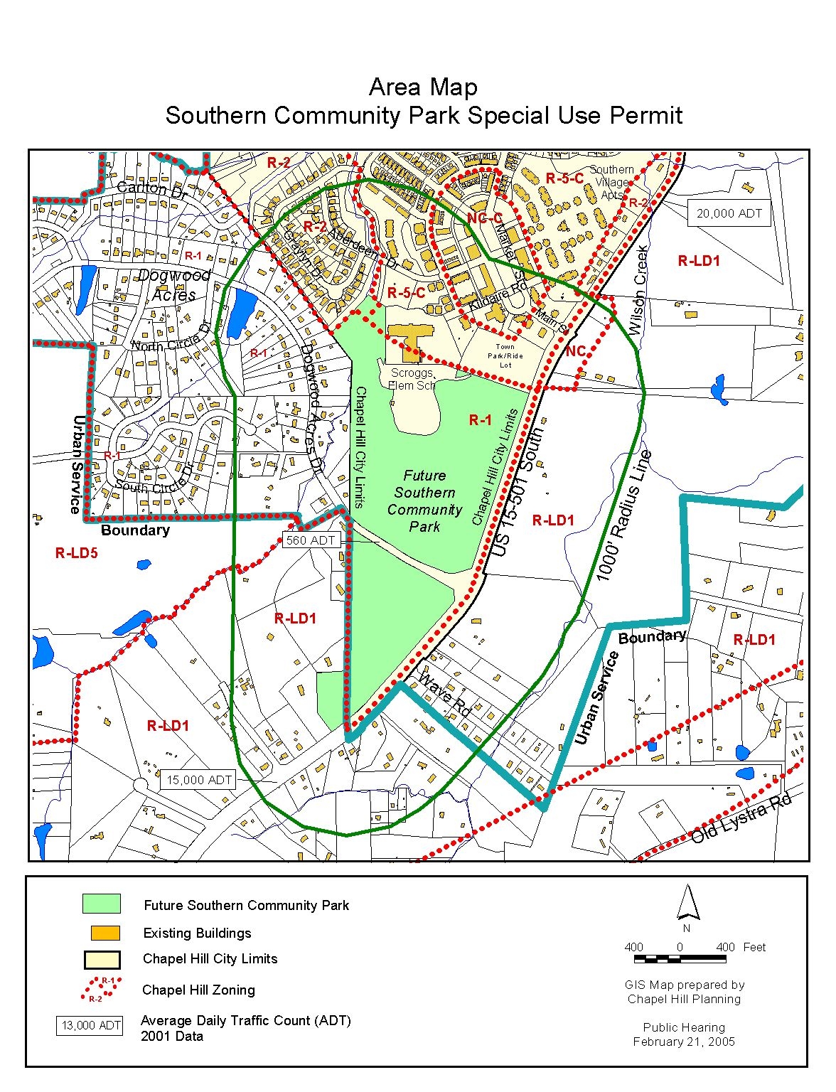