AGENDA #3b
to: Roger L. Stancil, Town Manager
from: J.B. Culpepper, Planning Director
Gene Poveromo, Development Manager
subject: Public Hearing: Residences at Grove Park at 425 Hillsborough Street, Special Use Permit (File No. 9788-39-4841)
date: April 21, 2008
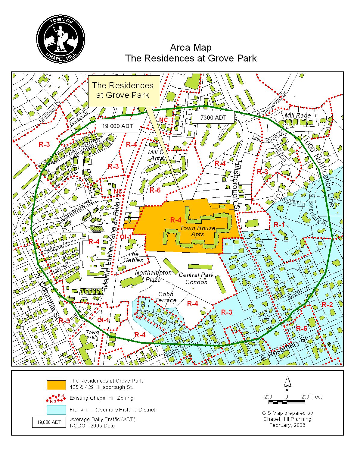
Attached for your consideration is an application from Ram Development Company for a Special Use Permit to allow a multi-family development with 492,634 square feet of floor area, including 346 dwelling units and 580 parking spaces on a 12.9-acre site. The site is located between Hillsborough Street and Martin Luther King Jr. Blvd. and is adjacent to North Hampton Terrace. The property is identified as Orange County Parcel Identifier Numbers 9788-39-4841, 9788-39-4857, 9788-49-1706, and 9788-49-4924.
This item was introduced at the March 10, 2008 Public Hearing. At the meeting, the Council referred the item to the staff pending additional recommendations from Town advisory boards. We have received those advisory board recommendations and our staff responses are included in this memorandum. The advisory boards’ Summaries of Action are included as attachments.
This development is not allowable under the current regulations. In order to create a regulatory environment in which it is allowable, the developer has proposed a new zoning district and rezoning. Approval of this proposal will require approval of the request to create a new zoning district and approval of the rezoning application. The proposal to create a new zoning district will be before the Council on May 5, 2008 following a March 10 Public Hearing. The rezoning request is described in the accompanying memorandum.
During staff and advisory board review, we identified twelve key issues related to this project:
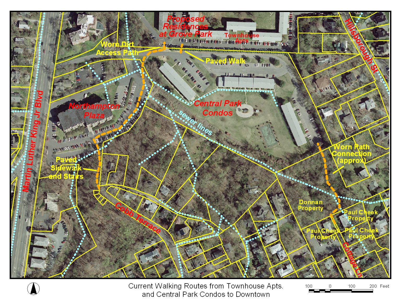
1. Cross-access Pedestrian Path: The staff has recommended that a pedestrian connection be provided to the adjacent properties on the north and south. At the Community Design Commission and Planning Board meetings, the adjoining property owner (Central Park Condominiums) and neighbors along Hillsborough Street voiced concerns that the proposed pedestrian connection to the south could increase trespassing and vandalism.
Comment: Some residents from Town House Apartments and the immediate neighborhood walk across the Central Park Condominium property to access stairs to Cobb Terrace. Residents also walk within an OWASA easement to access E. Rosemary Street and downtown. At the Planning Board meeting, residents from Cobb Terrace and Hillsborough Street complained of trespassing and vandalism, caused by individuals using these informal paths. Attached to this memorandum is an aerial photo identifying these informal pedestrian paths.
The owner of Central Park Condominiums also voiced concern that denser development could increase trespassing and vandalism and asked the applicant to construct a new brick wall on the Residence at Grove Park property to prohibit passage. A chain link fence currently exists on Central Park Condominium property along the shared property line. For additional comment on the request for a fence, please refer to the discussion topic number 2 below.
Town Staff has discussed possible future locations for pedestrian access between this site and Cobb Terrace/Rosemary Street. The Parks and Recreation Department have added this project to a list of future modifications to the Town’s Greenway Master Plan. In addition, we will continue to request greenway easements as surrounding properties are re-developed. To address pedestrian movement, the applicant is proposing a greenway easement for north/south pedestrian cross-access through the Resource Conservation District. Resolution A includes a stipulation for a greenway easement.
2. Fence along Southern property: The adjacent neighbor on the south (Central Park Condominiums) requested that the applicant construct a fence on the applicant’s property along the shared property line. We understand that the existing chain link fence on the Central Park Condominiums property has been damaged and replaced several times. Comments were presented to the advisory boards indicating that trespassing and vandalism are a problem for neighbors south of Central Park Condominiums and along Hillsborough Street. At the Planning Board and Community Design Commission meetings it was recommended that the applicant construct a 6-foot fence along their southern property line in response to the adjacent neighbor. The Planning Board recommended that the Residences at Grove Park Homeowners’ Association also assume responsibility in perpetuity for maintenance of the new fence.
Comment: We do not recommend a stipulation requiring this developer to construct a fence on their property along the southern property line. We do not believe that a fence is the best long-term solution to pedestrian movement and trespassing and vandalism concerns. Although vehicular and pedestrian connectivity is encouraged with new development, the adjacent neighbor does not want pedestrian traffic that is not from his development. We believe that the best solution may be both a pedestrian easement through the Resource Conservation District, as noted earlier, and a longer term goal of working with neighbors to identify location(s) for pedestrian connections to downtown and campus. We have not included a stipulation in Resolution A, our preliminary recommendation, requiring the construction of a fence.
3. Pedestrian Trails and Adjacent Property: At the Parks and Recreation Commission meeting, the Commission recommended that with this application there be no impact on neighboring properties from pedestrian circulation patterns and that existing and new public pedestrian trails be designed for future access to downtown and the campus.
Comment: The Commission’s recommendation for the development to have no impact on neighboring properties relating to pedestrian circulation patterns followed a presentation by the owners of the adjacent southern property. We believe the Commission’s discussion included an idea for the applicant to construct a fence along the southern property line. Our preliminary recommendation does not require a fence along the southern property line. The applicant is proposing a greenway easement to properties north and south of the development for a future pedestrian connection to downtown, campus, and a link to Bolin Creek Greenway. We believe that pedestrian impacts relating to this development will be minimized with the development’s proposed landscape buffer and new driveway construction requiring a retaining wall along the southern property line. Resolution A does not require a fence along the southern property line.
4. Affordable Housing: The Council has adopted a resolution stating an expectation that rezoning applications be accompanied with a Special Use Permit application that will provide 15 percent of the units at prices affordable to low and moderate income households. The applicant has proposed to satisfy the 15 percent affordable units by providing 52 affordable bedrooms with a mix of one and two bedroom units.
The proposed redevelopment of this site includes demolition of the existing Town House Apartments, removing the availability of 111 rental housing units.
Comment: Rather than provide 52 affordable dwelling units (15% of the 346 units), the applicant’s proposal would provide 52 affordable bedrooms with a mix of one and two bedroom units. On February 21, 2008, the applicant met with Town staff and staff from Orange Community Housing and Land Trust to discuss an affordable housing plan that includes a mix of one and two bedroom units. Recent Council approvals have incorporated affordable housing stipulations that addressed various options including the number of bedrooms as a measure of affordable housing. The Town staff and the Land Trust recommend the applicant’s plan to create a mix of one and two bedroom units. We recommend that these affordable units be disbursed throughout the condominium buildings. In addition, we recommend that the applicant implement a transfer fee policy for market rate homes. We believe that the transfer fee will help to ensure the continued affordability for the bedroom units. The Land Trust is working with the applicant to develop the specific terms of a Transfer Fee Fund for this project that would be used to subsidize the affordable units. The staff and the Land Trust recommend that the applicant enter into a Memorandum of Understanding with the Land Trust and the Town to govern the use of such a fund. Resolution A includes a stipulation to this affect.
5. Water Meters on Individual Dwelling Units: The Community Design Commission recommended that a stipulation be included in Resolution A requiring that each dwelling unit have its own water meter to monitor water usage.
Comment: OWASA does not recommend individual water meters for each dwelling unit. OWASA noted that special plumbing needs make the system infeasible. Alternatively, OWASA recommended a sub-metering system that allows individual dwelling unit responsibility for paying their water bill separately and thus provides some incentive for a user/customer to conserve. We have included our standard stipulation which requires OWASA approval of the proposal. Resolution A also includes a stipulation requiring a sub-metering system.
6. Construction Start Date and Completion Deadline: The applicant has requested an extension to the construction start date from two to three years and completion date from four to seven years.
Comment: The Town’s Traffic Engineer has indicated that a 7-year construction completion deadline, as requested by the applicant, would require the applicant to update the Traffic Impact Analysis.
Our standard recommendation to the Advisory Boards included a stipulation that construction begin within two years from the Council approval and be completed within four years of Council approval. Recently the Town Council has amended the construction completion deadline for a similar project from four years to five years. Resolution A includes a stipulation for a construction deadline of five years.
7. Sidewalk constructed on east side of roadway in front of Buildings 1 and 2: The Bicycle and Pedestrian Advisory Board recommended that a stipulation be included in Resolution A requiring that sidewalks be provided on the east side of the roadway in front of Buildings 1 and 2 and along one side of the pavement leading into the parking garage located between Buildings 1 and 2. The Board believed that this would improve pedestrian circulation within the site.
Comment: The east side of the roadway in front of Buildings 1 and 2 is in the Upland Zone of the Resource Conservation District. An additional sidewalk segment in front of Building 1 would add approximately 600 square feet of impervious surface and twice that amount of land disturbance inside the Resource Conservation District. Additional sidewalk in front of Building 2 would add approximately 1,400 square feet of impervious surface and twice that amount of land disturbance inside the Resource Conservation District. As we consider the benefits of sidewalks at these locations and the ordinance objectives to minimize impervious surface and land disturbance in the Resource Conservation District, we do not believe that the additional land disturbance/impervious surface inside the Resource Conservation District for additional sidewalks is merited. The Council may decide otherwise. Resolution A does not include a stipulation for sidewalks as recommended by the Bicycle and Pedestrian Advisory Board.
8. No Construction Traffic on Hillsborough Street: At the Community Design Commission meeting several residences of Hillsborough Street and the Franklin-Rosemary Historic District spoke of concerns of safety and noise associated with construction traffic on Hillsborough Street during development of the site.
Comment: We agree that construction traffic should be minimized on Hillsborough Street. The street is steep, narrow, and not conducive to large trucks. We believe that the Martin Luther King Jr. Blvd. entrance should be designated as the main construction entrance to the site. We have included a stipulation in Resolution A for construction traffic to be restricted on Hillsborough Street except: 1) when activity associated with work in the Hillsborough Street right-of-way is occurring; and 2) during improvements to the Martin Luther King Jr. Blvd driveway when such work results in the closing of this main driveway.
9. Reduce Vehicular Parking: At the Planning Board and Transportation Board meetings, reduced parking amounts were recommended, reasoning that the development is within easy walking distance to downtown and campus. The applicant proposes 580 vehicular parking spaces. The Planning Board recommended a maximum of 520 parking spaces and the Transportation Board recommended 524 maximum parking spaces.
Comment: Parking requirements for this development require a minimum of 467 parking spaces and a maximum of 586 parking spaces. The Planning Board and Transportation Board proposed to de-emphasize automobile usage by further limiting the number of vehicular parking spaces. The Planning Board recommended 520 parking spaces. The Transportation Board recommended 524 parking spaces. The applicant’s parking space proposal is within the maximum and minimum limits of the Land Use Management Ordinance. We have not revised the stipulation in Resolution A regarding the number of vehicular parking spaces.
10. Re-evaluate Traffic Impacts: At the Planning Board meeting, the Board recommended including a stipulation to re-evaluate traffic impacts of the development. The Board was concerned that the Traffic Impact Analysis did not properly reflect traffic impact projections.
Comment: The applicant submitted an updated Traffic Impact Analysis to the Town’s Traffic Engineer on March 26, 2008. The Town’s Traffic Engineer is working with NCDOT to review this intersection for signal phasing and geometric conditions. We will provide the updated executive summary of the Traffic Impact Analysis information at the April 21, 2008 Public Hearing.
11. Increase Bicycle Spaces: The Transportation Board recommended that the applicant increase the minimum bicycle parking numbers from 110 to 173 spaces. One space per six dwelling units is currently required. The applicant is proposing one space per three dwelling units. The Board is interested in changing the bicycle parking minimum requirements to one space per two dwelling units for multi-family developments. The Board has provided this recommendation for increased bicycle parking in order to encourage alternative modes of transportation.
Comment: The Land Use Management Ordinance requires that this proposed development provide at least 58 bicycle parking spaces: 52 Class I and 6 Class II. The applicant is proposing 110 parking spaces for bicycles: 60 in under-building parking lots, 40 spaces in the town house unit garages, and 10 surface spaces. The proposal for 110 parking spaces meets the Ordinance requirements. We have not revised our recommendation in Resolution A.
12. Modifications to the Regulations: The applicant is requesting that the Council approve modifications to Section 3.6.3(f)(1)) of the Land Use Management Ordinance: 1) additional impervious surface in the Upland Zone of the Resource Conservation District, and 2) additional land disturbance in the Upland Zone of the Resource Conservation District.
Comment: For discussion on this issue, please refer to the section on Modifications to the Regulations.
PROPOSED MODIFICATIONS OF REGULATIONS
Council Findings and Public Purpose: The Council has the ability to modify regulations in particular circumstances, according to Section 4.5.6 of the Land Use Management Ordinance if they make a finding in a particular case that public purposes are satisfied to an equivalent or lesser degree. We believe that the Council could modify the regulations if it makes a finding in this particular case that public purposes are satisfied to an equivalent or greater degree. The Council may deny one or more of the proposed modifications from regulations at its discretion. If the Council chooses to deny a request for modification to regulations, the applicant’s alternative is to comply with regulations or request a variance.
Impervious Surface in the Upland Zone of the Resource Conservation District: As proposed, the Special Use Permit application does not comply with the impervious surface area allowed in the Upland Zone of the Land Use Management Ordinance. Table 3.6.3(f)(1) of the Land Use Management Ordinance specifies a Disturbance Area Ratio for the Upland Zone of the Resource Conservation District of .20. This proposal contains 46,335 square feet of land area inside the Upland Zone. Using the .20 Impervious Surface Ratio, a maximum of 9,267 square feet of impervious surface is allowed. The applicant proposes 23,676 square feet of impervious surface area for driveway improvements. The applicant proposes to remove an existing driveway from the more environmentally critical Managed Use Zone of the Resource Conservation District and relocate it further from Mill Race Branch within the Upland Zone of the Resource Conservation District.
Land Disturbance in the Upland Zone of the Resource Conservation District: As proposed, the Special Use Permit application does not comply with the land disturbance limitations inside the Upland Zone of the Resource Conservation District of the Land Use Management Ordinance. Table 3.6.3(f)(1) of the Land Use Management Ordinance specifies a Disturbed Area Ratio of .40 for the Upland Zone of the Resource Conservation District. This proposal contains 46,335 square feet of land area inside the Upland Zone of the Resource Conservation District. Using the .40 Disturbance Area Ratio, a maximum disturbed area of 18,534 square feet of land area is allowed. The applicant proposes 37,955 square feet of land disturbance for improvements to the driveway and sidewalk. The applicant proposes to relocate the driveway further from Mill Race Branch within the Upland Zone of the Resource Conservation District. The application proposes dual egress to Martin Luther King Jr. Blvd., increased sight visibility, and a separate sidewalk to improve safety for pedestrians.
Comment: We recommend both modifications of the regulations. We believe the applicant’s request to increase the impervious surface and land disturbance beyond what the Land Use Management Ordinance permits will allow construction of a wider driveway with sidewalk for increased pedestrian and vehicular safety, improve emergency access with wider turning radii, and protect and enhance the sensitive environmental area within the Resource Conservation District by replacing existing impervious surface with earth and relocating the driveway further from the environmentally critical area of Mill Race Branch. We believe that the Council could modify the regulations in this case by making the finding that public purposes would be served, because pedestrian, vehicular, and emergency improvements are proposed and because a sensitive environmental area would be enhanced by removing asphalt and replacing it with earth.
RECOMMENDATIONS
Planning Board: The Planning Board met on March 18, 2008 and voted 6-1 to recommend that Council approve the Special Use Permit with the adoption of Resolution A with the following three changes:
Comment: We have not included a stipulation in Resolution A restricting parking to 520 vehicular parking spaces. For additional information, please refer to the Discussion section in this memorandum.
Comment: We have not included a stipulation in Resolution A to construct a fence along the southern property line. For additional information, please refer to the Discussion section in the memorandum.
Comment: The Town’s Traffic Engineer is currently reviewing a revised Traffic Impact Analysis. For additional information, please refer to the Discussion section in the memorandum.
A copy of the Summary of Planning Board Action is attached.
Community Design Commission: The Community Design Commission met on February 20, 2008 and voted 8-0 to recommend that Council approve the Special Use Permit with the adoption of the Resolution A with the following changes:
Comment: We have not included a stipulation in Resolution A for a fence along the south property line. For additional information, please refer to the Discussion section in this memorandum.
Comment: Resolution A includes a stipulation requiring sub-metering for each dwelling unit. For additional information on this stipulation please refer to the Discussion section in this memorandum.
Comment: Resolution A includes a stipulation restricting construction traffic on Hillsborough Street. For additional information please refer to the Discussion section in this memorandum.
A copy of the Summary of Community Design Commission Action is attached.
Bicycle and Pedestrian Advisory Board: The Bicycle and Pedestrian Advisory Board met on February 26 and voted 8-0 to recommend that Council approve the Special Use Permit with the adoption of the Resolution A with the stipulation:
Comment: We have not included a stipulation in Resolution A for sidewalks on the east side of the roadway in front of Buildings 1 and 2 and to the parking garage. For additional information, please refer to the Discussion section in this memorandum.
A copy of the Summary of Bicycle and Pedestrian Advisory Board Action is attached.
Greenways Commission: The Greenways Commission met on February 27, 2008 and voted 6-0 to recommend that Council approve the Special Use Permit with adoption of Resolution A. A copy of the Summary of Greenways Commission Action is attached.
Parks and Recreation Commission: The Parks and Recreation Commission met on March 19, 2008 and voted 8-0 to recommend that Council approve the Special Use Permit with adoption of Resolution A with the following recommendation:
· That the applicant be required to provide a safe and orderly system of public pedestrian paths and sidewalks that would have no negative impacts on adjacent neighbors.
Comment: We have not included this stipulation in Resolution A. For additional information, please refer to the Discussion section in this memorandum.
A copy of the Parks and Recreation Commission Summary is attached.
Transportation Board: The Transportation Board met on March 13, 2008 and voted 5-0 to recommend that Council approve the Special Use Permit with the adoption of Resolution A with the following changes:
Comment: Resolution A stipulates a minimum of 580 vehicle parking spaces. For additional information, please refer to the Discussion section in this memorandum.
Comment: We have not revised the stipulation in Resolution A requiring 110 bicycle parking spaces. For additional information, please refer to the Discussion section in this memorandum.
Staff’s Preliminary Recommendation: If the new zoning district is established and the property is rezoned, our preliminary recommendation is for Resolution A, approving the Special Use Permit application. Following advisory board review of the Special Use Permit application, the following items are included in Resolution A:
· The affordable housing stipulation recommends 52 affordable bedrooms rather than 52 affordable dwelling units.
· That the applicant installs a sub-metering system for water metering.
· Construction traffic is prohibited on Hillsborough Street, except for: 1) construction associated with work in the Hillsborough Street right-of-way; and 2 during construction associated with improvements to the Martin Luther King Jr. Blvd driveway.
· Construction completion deadline of 5 years.
A copy of a matrix comparing the differences between the above recommendations is included at the end of this memorandum.
Resolution B would deny the application.
PROCESS
The Land Use Management Ordinance requires the Town Manager to conduct an evaluation of this Special Use Permit application, to present a report to the Planning Board, and to present a report and recommendation to the Town Council. We have reviewed the application and evaluated it against Town standards; we have presented a report to the Planning Board; and tonight we submit our report and preliminary recommendation to the Council.
The standard for review and approval of a Special Use Permit application involves consideration of four findings (description of the findings follows below). Evidence will be presented tonight. If, after consideration of the evidence, the Council decides that it can make each of the four findings, and modifies the regulations as proposed by the applicant, the Land Use Management Ordinance directs that the Special Use Permit shall then be approved. If the Council decides that the evidence does not support making one or more of the findings, then the application cannot be approved and, accordingly, should be denied by the Council.
EVALUATION OF THE APPLICATION
We have evaluated the application regarding its compliance with the standards and regulations of the Town’s Land Use Management Ordinance. Based on our evaluation, our preliminary conclusion is that the application as submitted, including the proposed modification to the regulations with the conditions included in Resolution A complies with the regulations and standards of the Land Use Management Ordinance, and Design Manual, if the new zoning district is created and if the property is rezoned to the new district.
Tonight the Council receives our attached evaluation and information submitted by the applicant. The applicant’s materials are included as attachments to this memorandum. All information that is submitted at the hearing will be included in the record of the hearing. Based on the evidence that is submitted, the Council will consider whether or not it can make each of four required findings for the approval of a Special Use Permit. The four findings are:
|
Special Use Permit – Required Findings of Fact Finding #1: That the use or development is located, designed, and proposed to be operated so as to maintain or promote the public health, safety, and general welfare; Finding #2: That the use or development would comply with all required regulations and standards of the Land Use Management Ordinance; Finding #3: That the use or development is located, designed, and proposed to be operated so as to maintain or enhance the value of contiguous property, or that the use or development is a public necessity; and Finding #4: That the use or development conforms to the general plans for the physical development of the Town as embodied in the Land Use Management Ordinance and in the Comprehensive Plan. |
Following the Public Hearing, we will prepare an evaluation of the evidence submitted in support of and in opposition to this application.
SUMMARY
We have attached a resolution that includes standard conditions of approval as well as special conditions that we recommend for this application. With these conditions, our preliminary recommendation is that, with the rezoning of the property and the requested modifications to the regulations, the Council could make the four findings necessary in order to approve the application. Our recommendation, Resolution A, incorporates input from all Town departments involved in review of the application.
Residences at Grove Park Special Use Permit
DIFFERENCES AMONG RECOMMENDATIONS
|
Issues |
Staff’s Preliminary |
Planning Board |
Community Design Commission |
Transportation Board |
Bicycle/Ped. Adv. Board |
Greenways Commission |
Parks and Recreation Commission |
|
Sidewalk constructed at Bldg. 1 and 2 |
No |
* |
* |
* |
Yes |
* |
* |
|
Restrict construction traffic on Hillsborough St. |
Yes except for work in the Hillsborough St. right-of-way and MLKB driveway |
* |
Yes |
* |
* |
* |
* |
|
Construct Fence on S. property line |
No |
Yes |
Yes |
* |
* |
* |
* |
|
Indiv. Water Meters for condo. units |
No (sub-metering) |
* |
Yes |
* |
* |
* |
* |
|
Reduce Vehicular Parking beyond regulatory restrictions |
No, 580 spaces allowed |
Yes, 520 spaces allowed |
* |
Yes, 524 spaces allowed |
* |
* |
* |
|
Re-evaluate Traffic Study |
Yes |
Yes |
* |
* |
* |
* |
* |
|
Increase Bicycle Spaces |
No, 110 exceeds minimum requirement |
* |
* |
Yes, require 173 |
* |
* |
* |
|
No impact on adjacent properties from Ped. Paths |
Stipulation not included |
* |
* |
* |
* |
* |
Yes |
|
Construction Deadline |
5 Years |
* |
* |
* |
* |
* |
* |
*Issues not recommended, and therefore not included in the Recommended Resolution
ATTACHMENTS